Friday, August 7, 2015

Great White Shark Spotted Off Duxbury Beach


Do nothing at all seal-like this weekend, as an apex predator put in an appearance off of Duxbury Beach this morning.

Not only was he spotted, he was pinged. This was one of the sharks that Dr. Gregory Skomal tagged, and he was the first test of Duxbury's detect-a-tagged-shark beach protection plan. It passed, with flying colors, a test where a dead Duxburian may have been a failing grade.

The same pinger (there's probably a better term for that, I don't know, sorry) which told us that the shark was in the area is also telling us that he hasn't left the area yet. Yes, we have a new Duxbury celebrity, he's as large as a Grand Cherokee, and he eats human-shaped meals.

(Editor's notes: 1) A tagged GWS set off the Duxbury alarm on 7/11 and 7/17 of this year... 2) I spoke with the Atlantic White Shark Conservancy, and they said that the shark was spotted by a fisherman... 3) They didn't mention which tagged shark it was.)

Since he's sporting a pingy-thingy, we know that he is one of Dr. Skomal's sharks. That means that he migrated to Duxbury from Monomoy, almost certainly by hooking around Provincetown. That means that the Outer Cape's nightmare may be diffusing over to Duxbury.

Duxbury is usually spared the Cape traffic, too. Odd...

Again, his favorite food is seal. Do nothing at all seal like. Don't even listen to Seal.

We're sort of far back on the list of places that shark experts study (for now), so we don't really know why the shark is here, if he plans to summer here, if he leaves in the winter, if he's the one who tried that kayak out last summer... to be honest, we don't know all sorts of stuff about this shark. We know that he likes People Food.

Swimming was restricted today, at least on Duxbury's town beach. I doubt that people were lining up to dive in off Gurnet Road, either. A shark can rip you up smooth, and not many people win fights with sharks (note the Mick Fanning reference on Duxbury's town beach bulletin board). Be careful out there.


(Cheryl Manning on the pic, merci....)


Wednesday, August 5, 2015

Mattapoisett Hurricane Primer: Inundation And Evacuation

Note the "Mattepoisett" spelling...

Hurricane season is upon us, and we are nearing the peak of it.

Now, we're in Massachusetts, and we haven't been hit dead-on by a hurricane since the 1990s. That means that we don't get them often, and it means that we are long overdue.

They aren't a frequent enough event that you should walk around wringing your hands or anything. However, there are certain things that a wise person might do which can actually eliminate a lot of the hand-wringing.

Ironically, the first step to a peaceful mind is to view some Disaster Porn!

We have two maps for you to look at, and they are specific to your town. One is for Inundation, and the other is for Evacuation. They pertain to a direct-hit hurricane hitting your town at mean high tide.

"Inundation" means "covered in water," although you can call it a Deathflood or a Sea Plague if that gets your people motivated. It refers to which areas in town will be covered with seawater (important distinction, these maps do NOT project freshwater flooding) if you play host to a hurricane.

The map for Inundation (the top one) is color-coded, with light green, dark green, yellow and red. Those colors equate to which areas will get wet in what kind of storm, i.e. Category 1, 2, 3 and 4. Where you see colors changing on the map, that's where the experts think it will require a greater storm to flood that area in seawater.

The map for Evacuation (right) is less complicated. If you look at the Inundation map for a moment and then look at the Evacuation map, the logic will eventually make sense. The red areas of the map essentially say "Those People Have To Leave," and the yellow areas say "You Have To Leave, Too."

See how you compare to your neighboring towns with the complete list of Inundation maps and Evacuation maps.

Remember, storm surge is not the only threat from a hurricane. Things like falling branches, freshwater flooding, lightning, flying debris, slick roads, tornadoes, downed power lines, looters and a thousand other variables can mess you up plenty when the barometer drops heavy.

Mattapoisett's status as a hurricane target depends on a battle between the barrier effect provided by Falmouth and The Islands and the funnel effect that Buzzards Bay has on storm surge being pushed ahead of a big hurricane.

As we say in all of these storm articles we write, Buzzards Bay provides a similar effect on cyclones to what you see happen in Bangladesh. Water goes into the big end and the narrowing of the bay leaves the water with nowhere to go but Forward and Higher.

There is a saying that civilization stops at the waterline, and that we all enter the food chain after that... but not always at the top. Mattapoisett has taken shots from the sea on several occasions, be it shark attack (1930s) or monster storms in 1938, 1944, 1954 and 1991. You can see the post-Bob ruins of Master P in one of these fine videos collected by my main man at West Island Weather.

Aside from the torn-apart-coastline shots you see with every storm, Matty P also offers a unique chance for the ocean to shut down not one but two major highways. Estimates vary, but even a Category 3 storm (granted, which would be among the worst in the state's White Guy history) would run a strong chance of making both Route 6 and Route 195 impassable in the Mattapoisett River area. Aucoot Cove flooding of a high order could also send ocean water across Route 6.

Aside from coves and river mouths, Matta P also gets flooding along her immediate coastline. It's not the place you want to be if a storm hits. As you might imagine, Matty has an extensive area which would merit evacuation in even a moderate hurricane. Places along the Mattapoisett River would be evacuated up to 195 in a minimal hurricane, and a slobberknocker of a storm woud push evacuations due to ocean water flooding miles past 195.

A hurricane in Mattapoisett ain't to be played with. Anyone who lives there, or even anyone who plans to visit, should be aware of which areas are prone to flooding and which areas will need to be evacuated.

We want you alive for monetary reasons, as we live off your site visits. We want you alive for professional pride reasons, i.e. "If they listened to me, they lived." We also want you alive for regular, nice-people reasons. Like the Boy Scouts say, "Be prepared."


Eastwick Meets The East Wind: A Cohasset Hurricane Primer


Hurricane season is upon us, and we are nearing the peak of it.

Now, we're in Massachusetts, and we haven't been hit dead-on by a hurricane since the 1990s. That means that we don't get them often, and it means that we are long overdue.

They aren't a frequent enough event that you should walk around wringing your hands or anything. However, there are certain things that a wise person might do which can eliminate a lot of the hand-wringing.

Ironically, the first step to a peaceful mind is to view some Disaster Porn!


We have two maps for you to look at, and they are specific to your town. One is for Inundation, and the other is for Evacuation. They pertain to a direct-hit hurricane hitting your town at mean high tide.

"Inundation" means "covered in water," although you can call it a Deathflood or a Sea Plague if that gets your people motivated. It refers to which areas in town will be covered with seawater (important distinction, these maps do NOT project freshwater flooding) if you play host to a hurricane. 

The map for Inundation (the top one) is color-coded, with light green, dark green, yellow and red. Those colors equate to which areas will get wet in what kind of storm, i.e. Category 1, 2, 3 and 4. Where you see colors changing on the map, that's where the experts think it will require a greater storm to flood that area in seawater.

The maps for Evacuation (right and below) are less complicated. If you look at the Inundation map for a moment and then look at the Evacuation map, the logic will eventually make sense. The red areas of the map essentially say "Those People Have To Leave," and the yellow areas say "You Have To Leave, Too."

See how you compare to your neighboring towns with the complete list of Inundation maps and Evacuation maps!

Remember, storm surge is not the only threat from a hurricane. Things like falling branches, freshwater flooding, lightning, flying debris, slick roads, tornadoes, downed power lines, looters and a thousand other variables can mess you up plenty when the barometer drops heavy.

Cohasset doesn't get the storm-love that Scituate gets. Part of this is from the more northern tilt to her beaches. Part of it is the armor of a rocky coastline, as those offshore rocks and ledges can knock the oomph out of a storm wave. A great part of it is Scituate sticking her Scituate Neck out to block Cohasset from the full effects of the east wind. 

In the end, Cohasset slides a bit. If you see a rich person's beach house getting washed away, it's more likely to be from Duxbury than Cohasset.

We sort of butchered the part where we cleanly upload the Cohasset evacuation map, but enough of the Scituate and Hull maps will bleed into C City that you can get the general idea. With evacuation, the general rule is When In Doubt, Get Out.

Most of Cohasset's housing is in the east side of town, and rightfully so. This will put many people in the Inundation area, and, shortly before or after, in the Evacuation area. Beach Street and Atlantic Avenue will live up to their names. Joy Place almost certainly will not.

No elitist, Mother Nature will also have herself a few swings at Jerusalem Road. One of the great differences between hurricanes and tornadoes is that the rich suffer disproportionately in coastal storms due to their habit of buying up shoreline property, while tornadoes- using logic which only they understand- prefer trailer parks.

The worst omission from my evacuation maps was the area of Cohasset along the Scituate border, which has a coastal river as the dominant feature. Ocean water loves to surge up coastal rivers during hurricanes, and Cohasset will see this first hand if a major storm arrives. Anything west of Scituate Neck, and anyone along a river, should be evacuated.

You can view Cohasset's evacuation map right here.

As always, know that hurricanes are rare in these parts. They have to plow through either the South Coast or Cape Cod (and then fight through the South Shore) before they even think about Cohassle. By the time they arrive, they will be considerably weakened.

Still, you want to be careful if the weather gets nasty. There are plenty of ways to die in Cohasset during a hurricane, and most people only need one.

Remember, as we say on Duxbury Beach, the other 364 days of the year look sort of like this!


Tuesday, August 4, 2015

Truro Hurricane Primer: Inundation And Evacuation


Hurricane season is upon us, and we are nearing the peak of it.

Now, we're in Massachusetts, and we haven't been hit dead-on by a hurricane since the 1990s. That means that we don't get them often, and it means that we are long overdue.

They aren't a frequent enough event that you should walk around wringing your hands or anything. However, there are certain things that a wise person might do which can actually eliminate a lot of the hand-wringing.

Ironically, the first step to a peaceful mind is to view some Disaster Porn!

We have two maps for you to look at, and they are specific to your town. One is for Inundation, and the other is for Evacuation. They pertain to a direct-hit hurricane hitting your town at mean high tide.

"Inundation" means "covered in water," although you can call it a Deathflood or a Sea Plague if that gets your people motivated. It refers to which areas in town will be covered with seawater (important distinction, these maps do NOT project freshwater flooding) if you play host to a hurricane. 

The map for Inundation (the top one) is color-coded, with light green, dark green, yellow and red. Those colors equate to which areas will get wet in what kind of storm, i.e. Category 1, 2, 3 and 4. Where you see colors changing on the map, that's where the experts think it will require a greater storm to flood that area in seawater.

The map for Evacuation (right) is less complicated. If you look at the Inundation map for a moment and then look at the Evacuation map, the logic will eventually make sense. The red areas of the map essentially say "Those People Have To Leave," and the yellow areas say "You Have To Leave, Too."

See how you compare to your neighboring towns with the complete list of Inundation maps and Evacuation maps.

Remember, storm surge is not the only threat from a hurricane. Things like falling branches, freshwater flooding, lightning, flying debris, slick roads, tornadoes, downed power lines, looters and a thousand other variables can mess you up plenty when the barometer drops heavy.

Truro is very exposed to the sea, but also has a few advantages that limit the damage of hurricanes somewhat. Most people in Truro live on the bay side of town, rather than the open ocean part. Truro's east-facing beaches have an impressive wall of dunes that swat down ocean waves like they were goaltending.

Truro is also well-positioned in that hurricanes that hit them will be somewhat blunted by contact with the South Coast or the more western/southern parts of Cape Cod. Cape Cod Bay is colder than the Gulf Stream Atlantic or even Buzzards Bay, and cold water is the deathblow for a hurricane.

This doesn't mean that you should schedule 18 holes or anything. Truro will be a very dangerous place to be in a hurricane. Pamet Harbor becomes the Pamet Marsh and then becomes the Pamet River and flows into Pamet Hollow. All of them will be a fine way for ocean water to move ashore.

Pamet Harbor is going to be the first place that the water starts coming ashore, and some other parts of town (including the beaches east of East Harbor) will also flood during minimal hurricanes. The land east of East Harbor around Pilgrim Lake would also be a threat to flood, although it require a next level-type of storm. Corn Hill Beach and Fisher Beach could go submarine if the storm is bad enough.

Truro is in the mix as far as worrying about hurricanes goes, and any resident (or even visitor) should have an idea of where they score on these maps. 

Hey, we'll throw in the Provincetown map, because we're good like that!
"Truro" is one of the very few words that people with Boston accents pronounce both Rs in...


Kingston Hurricane Primer: Inundation And Evacuation


Hurricane season is upon us, and we are nearing the peak of it.

Now, we're in Massachusetts, and we haven't been hit dead-on by a hurricane since the 1990s. That means that we don't get them often, and it means that we are long overdue.

They aren't a frequent enough event that you should walk around wringing your hands or anything. However, there are certain things that a wise person might do which can eliminate a lot of the hand-wringing.

Ironically, the first step to a peaceful mind is to view some Disaster Porn!

We have two maps for you to look at, and they are specific to your town. One is for Inundation, and the other is for Evacuation. They pertain to a direct-hit hurricane hitting your town at mean high tide.

"Inundation" means "covered in water," although you can call it a Deathflood or a Sea Plague if that gets your people motivated. It refers to which areas in town will be covered with seawater (important distinction, these maps do NOT project freshwater flooding) if you play host to a hurricane. 

The map for Inundation (the top one) is color-coded, with light green, dark green, yellow and red. Those colors equate to which areas will get wet in what kind of storm, i.e. Category 1, 2, 3 and 4. Where you see colors changing on the map, that's where the experts think it will require a greater storm to flood that area in seawater.

The map for Evacuation (right) is less complicated. If you look at the Inundation map for a moment and then look at the Evacuation map, the logic will eventually make sense. The red areas of the map essentially say "Those People Have To Leave," and the yellow areas say "You Have To Leave, Too."

See how you compare to your neighboring towns with the complete list of Inundation maps and Evacuation maps.

Remember, storm surge is not the only threat from a hurricane. Things like falling branches, freshwater flooding, lightning, flying debris, slick roads, tornadoes, downed power lines, looters and a thousand other variables can mess you up plenty when the barometer drops heavy.

Kingston is somewhat shielded from the worst effects of a hurricane by several factors.

1) Any hurricane that hits Kingston is going to have made landfall somewhat south of Kingston, either on the South Coast or on Cape Cod. That will weaken it, and The Town Of Kings wont get any of that Hurricane Bob damage unless the storm is a true behemoth.

2) Another benefit that Kingston enjoys is the double wall of barrier beaches provided by Duxbury Beach and Long Beach in Plymouth. Throw in the even larger barrier beaches for Kingston that are the South Coast, the Upper Cape and the Outer Cape, and Kingston is (relatively) catching softballs.

3) Kingston Bay is shallow, which is sort of offset by the fact that some coastal areas of Kingston are low-lying.

4) Other than the head of the bay (which is also where a river empties, no small consideration in a storm where 6-12 inches of rain could be falling), a lot of the Kingston coast is in no great danger other than directly at the coast.

5) A lot of the area in Kingston that will flood is undeveloped.

6) Water is only predicted to make it deeper ashore (Jones River flooded with ocean water out to Route 106) in a Category 4 hurricane, which hasn't hit New England since the Paleface Man arrived.

This doesn't get K off the hook, though. Kingston has suffered storm damage in the past, and the future promises even more.

The jackpot areas seem to be Jones River Beach, the direct shores of Rocky Nook, Gray's Beach and especially Bay Farm. Bay Farm will take the most flooding, but it also has the least development. 

In short, Kingston probably won't be Ground Zero for some Katrina-style event. You might be in the news story, but you'll be in the small print unless a school gets leveled. Still, you want to memorize this information and base a plan around it. We need you alive to provide site visits for us.

Cover Your Assonet: A Freetown Hurricane Primer


Hurricane season is upon us, and we are nearing the peak of it.

Now, we're in Massachusetts, and we haven't been hit dead-on by a hurricane since the 1990s. That means both that we don't get them often, and it means that we are long overdue.

They aren't a frequent enough event that you should walk around wringing your hands or anything. However, there are certain things that a wise person might do which can eliminate a lot of the hand-wringing.

Ironically, the first step to a peaceful mind is to view some Disaster Porn!

We have two maps for you to look at, and they are specific to your town. One is for Inundation, and the other is for Evacuation. They pertain to a direct-hit hurricane hitting your town at mean high tide.

"Inundation" means "covered in water," although you can call it a Deathflood or a Sea Plague if that gets your people motivated. It refers to which areas in town will be covered with seawater (important distinction, these maps do NOT project freshwater flooding) if you play host to  hurricane. 

The map for Inundation (the top one) is color-coded, with light green, dark green, yellow and red. Those colors equate to which areas will get wet in what kind of storm, i.e. Category 1, 2, 3 and 4. Where you see colors changing on the map, that's where the experts think it will require a greater storm to flood that area in seawater.

The map for Evacuation (right) is less complicated. If you look at the Inundation map for a moment and then look at the Evacuation map, the logic will eventually make sense. The red areas of the map essentially say "Those People Have To Leave," and the yellow areas say "You Have To Leave, Too."

You'd think that saltwater flooding would be something Freetown people wouldn't have to worry about, but No.

Freetown has the ominously-named Three Mile River (never name a river or an island "Three Mile" or even "Eight Mile," for that matter) flowing up in her guts from Mount Hope Bay. The Taunton River also gets in on the saltwater redistribution action.

Those rivers are fine conductors of ocean water, should a large surge push ashore. This makes the village of Assonet very vulnerable. Assonet Bay Shores, which is already out in the water some, could become Atlantean in a bad enough storm.

It could also be tough to get to the Stop 'n' Shop Redistribution Center, so get that bread and milk early.

I kind of hung the + and - zoom thingy over Assonet in the shot at the bottom, my bad, folks.

The Commonwealth was good enough to supply us with a pile of maps for coastal communities. Here are the Inundation Maps for each town, and here are the Evacuation Maps. See how good you have it compared to your neighbors.

Freetown is a small town, although it covers a good sized area. Most of that area, and I mean like 98% of it, won't have to worry about ocean water. However, like the Mexican politician said when an American told him that the US "didn't take that much of Mexico,' a hurricane will take "the part with the roads."

Ocean water is only one small part of the danger associated with hurricanes. You don't ever have to see salt water to get high winds, flying debris, downed wires, freshwater flooding, lightning strikes, sewer overflow, tornadoes, looters, falling tree limbs... you know, the whole nine.

However small a town Freetown may be, you can be sure that it will cost more than 20 coats, some cookware, some cloth, some iron tools (supporters of a Wampanoag casino will be pleased to know that the purchase price of Freetown included "a dozen hoes") and a hatchet to rebuild Freetown.

Knowledge is power, so get a good look at these maps, see what the score looks like for your house, and have the bones of a plan in place by the time hurricane season gets on... which, unfortunately, is Now.


Monday, August 3, 2015

Wareham Hurricane Primer: Inundation And Evacuation


Wareham has a long and lengthy history with ol' Mister Hurricane. Just looking at that map above without knowing what it means, you can see that trouble would be afoot for ?ham if the barometer drops too much.

Wareham has taken beatings from Hurricane Bob, the Long Island Express, and a dozen other storms, and that's just in White Guy history. If you work in the native population, the numbers become countless after an eon or ten.

The 'Ham ( I really want to write a cop show for TV, base it in Onset, and call it "The 'Ham") suffers from the same problem which places like Bangladesh have.... it exists at the tip of a funnel. The funnel is formed by Buzzards Bay. That's the body-of-water Buzzards Bay, not the village part of Bourne... those people share the same Bangladeshian funnel problem that ?ham has.

Hurricanes, with both the wind and storm surge, push water ahead of them. That's actually what the storm surge is. It's not a problem in the middle of the Atlantic, but that water has to come ashore somewhere, and that somewhere is often at what they call the head of the bay. That's Wareham.

In fact, the "where" sound in Wareham may actually refer to "where the water goes." Water cares very little about washing over roads, cars, houses, people....  once it gets off the beach, we have a natural disaster on our hands.

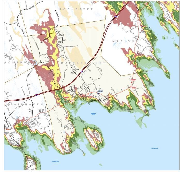
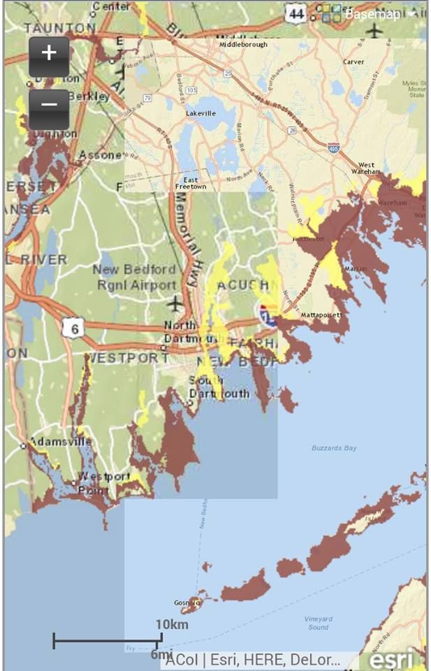
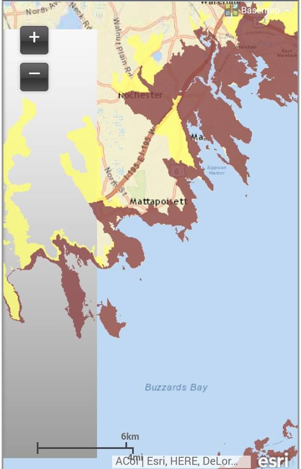
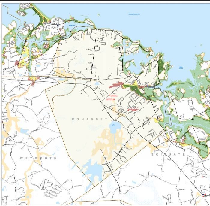
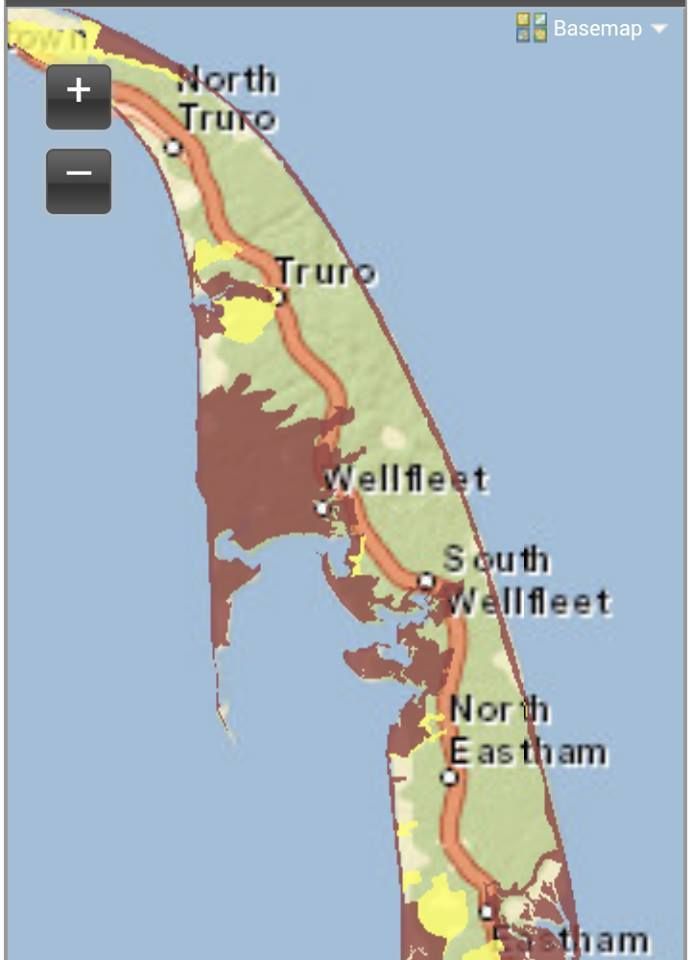
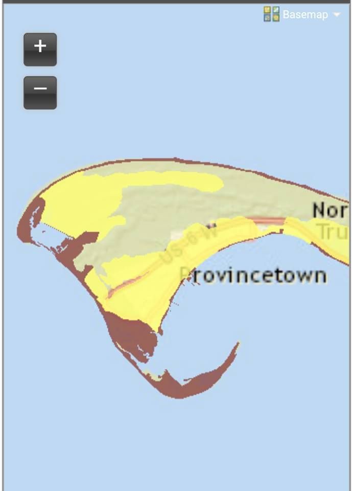
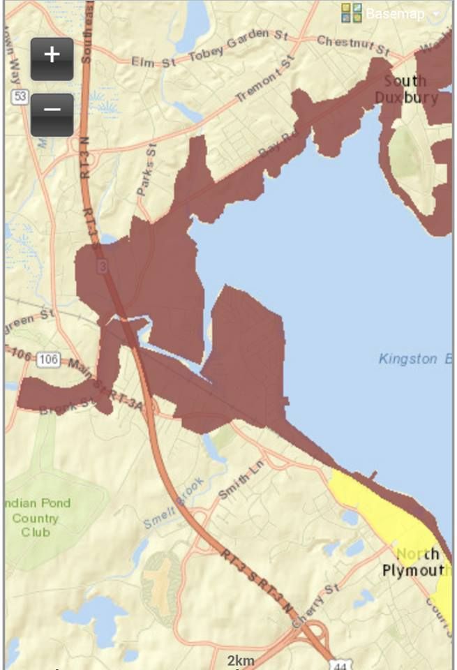
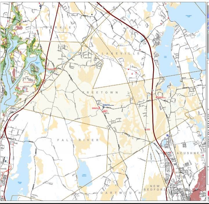
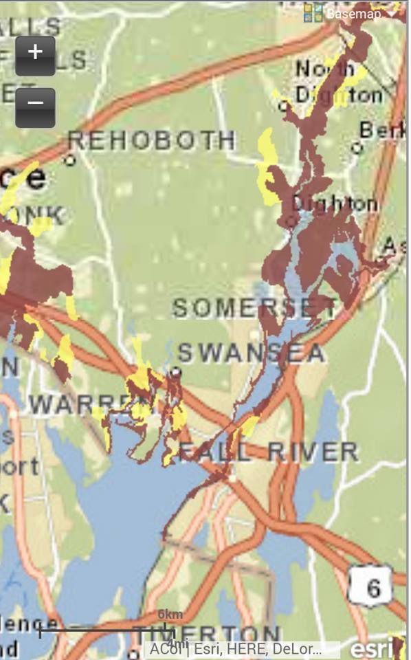
You have two maps here, folks... the upper one shows Inundation, and the lower one shows Evacuation Zones. The maps are from June of 2014, and- to my knowledge- are the plan du jour.

"Inundation" is a nice, painless term that means "covered in water," but you can change it to "Deathflood" or "Sea Plague" if it gets the troops moving quicker.

They (these maps are produced by the National Hurricane Center) assume that Wareham gets a direct hit at high tide, and follow the (groan) SLOSH model of seawater redistribution that MEMA and others use. They are assuming worst case everything insofar as wind direction, phase of moon (check that, they use Mean High Tide), forward speed of the storm and everything else goes.

Those pretty colors are actually differing levels of devastation. I had a map/legend thingy in the Photobucket somewhere, but I'll just say that light green is a Category 1 storm, dark green is a Category 2, yellow is a Category 3, and red is a Category 4.

For a basis of comparison, what Wareham got from Hurricane Gloria may have been a weak Category 1 storm (she came ashore in Connecticut), the Blizzard of '78 was about a strong Category 1/weak Category 2, Hurricane Bob was  moderate Category 2 ("moderate" and "Category 2 hurricane" are kind of odd words to string together), old timers may have witnessed Hurricane Carol at Category 3, and The Great New England Hurricane of 1938 was a strong Category 3 made worse (Blue Hills got a 186 mph wind gust) by her forward speed.

The colors show which sort of storm will inundate which areas. Light green means you are hurting in even a weak hurricane. Any shift in colors after light green means that the storm will have to kick it up a notch to reach that area. Red areas are places that will only suffer- but suffer they will- in a Category 4 storm, the likes of which hasn't been seen by White Men in these parts. Hurricane Bob was our 11th deadliest storm ever in Massachusetts, in case you were wondering where your memories rank all-time.

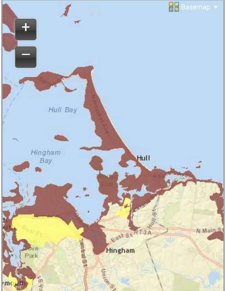
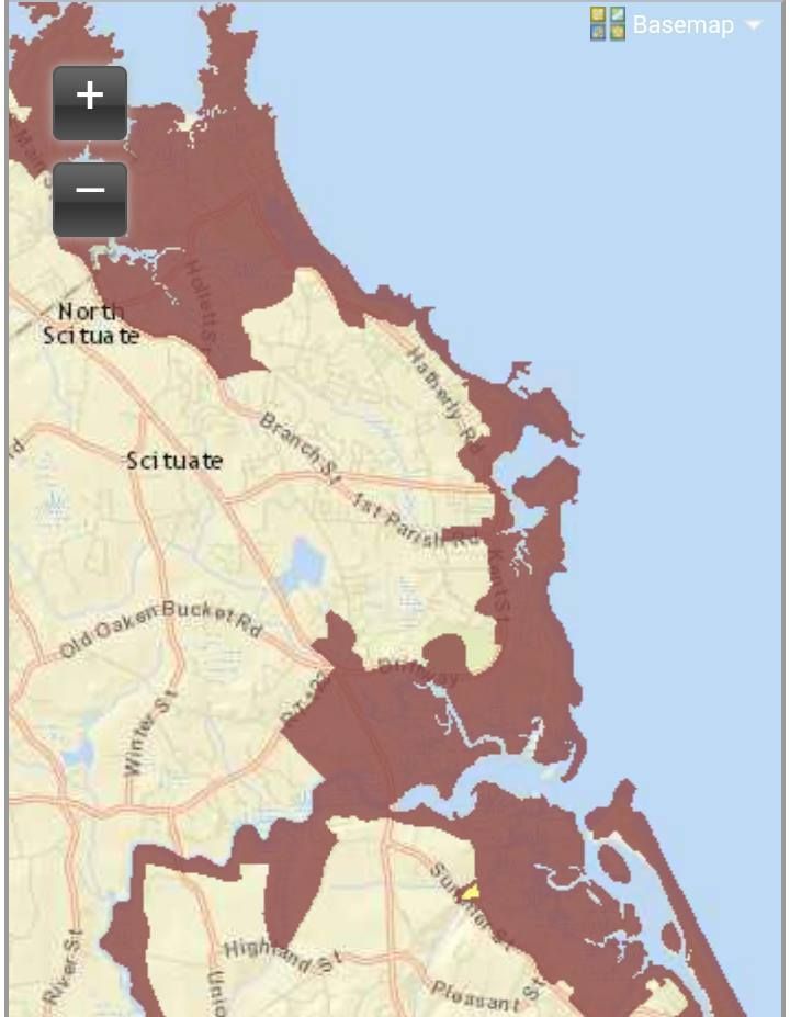
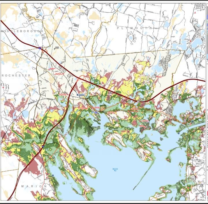
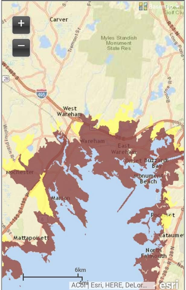
The lower map, Evacuation Zones, is a bit easier to follow. They have three zones of evacuation. The third zone is reserved for storms we don't get, because I never saw the third color, and I looked at 30 town maps. The other colors break down as red = They Have To Leave and yellow = You Have To Leave, Too.

If you stare at the top map a bit an then stare at the bottom map, you'll get the basic idea of the Hows and Whys.

This is a frightening amount of Inundation territory. Wareham is home to 21,000 people. Almost all of them would be underwater in this scenario. To make it worse, these maps only show part of the problem. There will be high winds, downed wires, falling tree limbs, river flooding, sewer overflow, road washouts... you know, the whole nine.

I can leave the worrying to you. It's my job to provide the maps and some insight. My work is done here. Godspeed.


Hurricane Inundation Maps

Evacuation Zone Maps