Ladies and gentleman, friends, Romans, countrymen, and children of all ages.... we proudly present to you the Fairhaven Hurricane Primer!
We're here today to tell you what parts of town will flood, how bad of a storm would be required to flood them out, and where the authorities will be evacuating people. This article will make you expert in all that stuff.
To be 100% cool, you want to either A) draw upon your knowledge, gained from you being in Fairhaven for a signature storm like Hurricane Bob, Hurricane Donna or even- if you're 0ld/old- the Great New England Hurricane of 1938, or B) talk to an old-timer who lives near you and has all that Bob/Carol knowledge down in his memory.
Local knowledge is immeasurably important. I study weather, I grew up on a Massachusetts beach, I live on a beach off Buzzards Bay now, I date a Fairhaven girl and visit her home beach once a season or so... and I still don't know Fairhaven in my bones. I have just this morning found out that I can't say the word "Fairhaven" properly. I say "Fair-haven," which audibly makes two words of it. My girlfriend, who grew up on West Island, says "Fa'haven," which is somehow less than one word.
I have a lot of scientific knowledge, and I have some informative maps to share... but in the end, you don't want to finalize your plans before you talk to a wise old local.
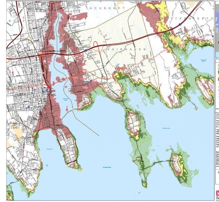
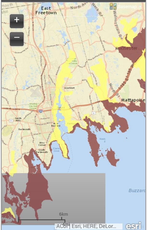
This map is what they (FEMA, MEMA, NOAA and NHC) call a Hurricane Inundation Map. It projects where the storm surge will go, and what intensity of storm would be needed to reach certain areas. They are based on the aptly-titled SLOSH model of inundation forecasting.
Storm surge, as you know, is the water pushed ashore as a big storm hits. It is the big killer in hurricanes, and even in history. The worst disaster related to lives lost in US history wasn't terrorists with planes or an earthquake, it was the storm surge associated with the 1900 Galveston hurricane.
OK, I think Antietam has it beat, but I digress...
Storm surge can also be called a Deathflood or Liquid Misery if that gets your people moving quicker. Either way, it's what those colors on the map above are showing. The differences in color depict where a more powerful storm (power = Saffir-Simpson hurricane intensity scale) would be required to inundate an area.
The maps depict a direct hit from a hurricane at mean high tide. They do not and I repeat NOT account for freshwater flooding, river swelling, sewers overflowing, and 7 inches of rain.
Your colors:
Light green = Category 1 storm. Hurricane Gloria would be a good example of a Cat 1. If you worked your way over to Fairhaven from the South Shore, the Halloween Gale would be a good example of a strong Category 1.
Darker green = Category 2. Hurricane Bob was a moderate Category 2 hurricane ("moderate" and "Category 2 hurricane" are tough words to string together, but that's how they roll at the NWS) upon landfall in Rhode Island.
Yellow = Category 3. Only 5 storms of this intensity have struck New England since the Other Man arrived in the 1600s. The most recent was Hurricane Carol in 1954.
Red = Category 4. We've had one storm of that intensity, the Great Colonial Hurricane of 1635.
Flesh = 100 year FEMA estimates. I presume this is the "100 year storm" that you hear about, and we haven't had one in modern (read: "white guy") history. "Flesh" is my non-artist word for that color, and is drawn from my Crayola days, before Crayola realized that black kids liked to color, too. It may be "apricot" or "off-whitey" these days, I'm not 100% sure.
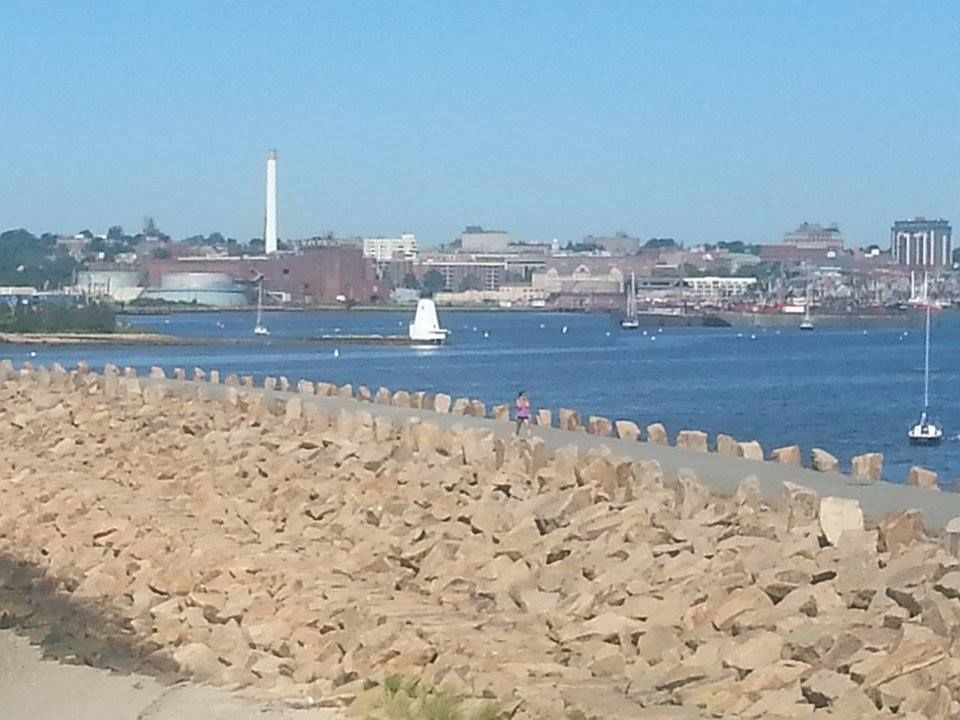
Inundation-wise, Fairhaven is indeed A Tale Of Two Cities (and a few island/peninsula things). You have the area by the Acushnet River. This would normally be a death zone, but they built a hurricane barrier (seen, from what I hope you notice is the Fairhaven side, in the picture at the beginning of the article) at the river's mouth. That protects everything behind it from anything other than a biblical, build-an-ark style flood. We may be wrong, but SLOSH says that only a Cat. 4 storm can get past it.
A storm in the Cat. 4 range wouldn't flood a large % of Fairhaven, but it would flood the area where most everyone in Fairhaven lives. That means we're evacuating about 15,000 souls. We'll get to that in a minute.
The other part of Fairhaven, which is a nice way of saying "the part without the 20 foot stone wall built in front of it," doesn't have it so good. They'll be hurtin' for certain in smaller storms. You can check your own neighborhood (or laugh at the suckers in other neighborhoods) by viewing the links I'll plop down somewhere in this article.
A pretty bad place to be in a storm would be West Island and/or anything off Sconticut Neck Road. The swampy parts go under right away, and an intense storm would start taking houses. A storm of Bob size floods almost 75-90% of these land masses.
If you live on West Island, you want to do this:
- Go find a topographical map, or zoom in really close on the FEMA map.
- Figure out who lives on the highest ground.
- Befriend that person, and butter them up like a biscuit. You want him saying "Come on in" when you show up at his house in a tempest.
- Have an evacuation plan that not only includes "get to the town-designated shelter," but also "get to High Ground Guy's house." If the only road out gets cut off, he may be your best bet.
A few other things stand out when you look at this map.
For starters, a storm of Bob's strength would cross over Route 6 right about where the Stop 'n' Shop is. A storm of Katrina strength would put most of Route 195 by the Acushnet River underwater. Weaker storms would flood Route 6 and Route 195 in Mattapoisett, in case if you decided to think outside of the box and flee East.
West Island is actually East of everything. I'd ask Jessica about this, but she's at work. Keep in mind, I thought that Fairhaven was where Popeye lived until I opened the Wikipedia. Either way, be off of West Island if a storm comes... even a small one.
If you live in the White section of town (hurricane maps are egalitarian, and I have discovered that "white" sections of town are often poorer, while "colored" sections of the map are usually inhabited by wealthier, less swarthy waterfront home-having people), you might think you're off the hook. Remember that these maps only show storm surge, not freshwater or river flooding... and also remember that trees tend to blow over during storms.
In an Andrew-style storm, every single road leading out of Fairhaven would be compromised to some extent. Even the side streets will be under. That means you can't get out, and it means that help can't get in.
You want to be Ghost before then, which leads to our next map:
This is an Evacuation Map. It is what the authorities will use to decide who has to stay and who has to go. You don't HAVE to go, but you also don't want to rely on the cop you were just reading the Constitution to risking his neck to pull you out of the maelstrom.
The map is easier to read than the Inundation map. On this map, Red means "they have to leave," and yellow means "you have to leave, too."
This is the cell phone version of the map, you can zoom in for much better detail using the map on MEMA's page.
Route 240 looks like a good evacuation route, even though you'd eventually get pinned in a bad enough storm.
If you live in Fairhaven or if you plan to vacation there, you should have at least the bones of an evacuation plan in place. Fairhaven, unlike other towns we cover, stands in line for a possible direct hit from a hurricane that approaches New England.
We want you alive. We want you alive for selfish reasons, as- if you are reading this and may return- you are our source of revenue. We want you alive for professional reasons, i.e. "If they listened to us, they'd be alive." We also want you alive for homeboy reasons, as one of the founders of this website is a Fairhaven girl, and we consider Fairhaven to be our spiritual South Coast road office. We also want you alive for regular, kind person reasons.
We've had sort of a slow summer for hurricanes. It's not like New England gets them very often, and we certainly are not a hotspot... but we at least get Threatened with one now and then. This summer? Nada.
There are good, valid, known reasons for this as-it-stands-now lack of tropical action. For one, we have seen tons of Sahara Desert dust being blown offshore. They've had a dry summer over there, and the Sahara dust interferes with water heating and surface-to-air evaporation... both of which are crucial to hurricane formation
We've also had a gorgeous summer. We get these summers because a big area of high pressure sets up near us. High pressure circulates clockwise. Low pressure circulates counter-clockwise. When they meet, the low pressure system gets sheared. When that happens, it's pretty much all she wrote for Tropical Storm Whoever.
So, to summarize, you've had a dry summer in Africa, and any tropical waves which come off the Dark Continent that aren't smothered by dust are then stopped by shear. Hence, the lack of hurricane reporting going on in these parts.
Conditions do not look favorable for development in the eastern Atlantic in the upcoming week, but things could yet pick up. However, we are not here today to talk about the future... we're here to talk about the past.
New England, despite not being Florida or Louisiana, does have an impressive hurricane history. We've been hit by some doozies. Cape Cod, which is sort of the chin of New England, usually bears the brunt of our hurricanes, although the body shot that is a Connecticut landfall also has an impressive history.
Since we're a Cape Cod news site, we'll use Cape impact as the deal-breaker when assembling this list of storms. We'll use impact on population as well, so many pre-Columbian monster storms will miss the list despite their power still being apparent 1000 years after the fact.
This history is also mis-calibrated into post-1620 bias due to the writes-down-their-history style of the Paleface. I'm sure that the Eastern Woodlands people had seen plenty of Biggies by the time that the Mayflower arrived. Either way, everything before 1635 gets to share one paragraph.
Conversely, many storms which are merely overgrown nor'easters will appear on this list solely because Cape Cod had more people living there when ranked Tropical Storm Irene hit in 2011 than when the similar but unranked 1683 tropical storm arrived and disturbed 1200 Pilgrims.
So, let's review some history, and set a benchmark for historic storms. If I have to re-write this list soon, you'll most likely have lost your roof.
We'll go by date, rather than ranking. If I skip your favorite storm, I guess it just wasn't a True Player.
Pre-Pilgrim
Recent innovations allow researchers to guess when big storms hit before recorded history.
I've seen them doing it at the Great Salt Marsh in Duxbury. They drill for soil samples, get a ten foot tube full of soil, then analyze layers of mud to see when some sand unexpectedly appears over marsh mud. This sand could only be put there by a storm big enough to wash beach sand over the dunes and into the marsh. Once they find sand, they do some Science/Math stuff (it is unbecoming to the sportswriter, all this Book Learning that you speak of...), and can determine when big hurricanes struck the area.
Therefore, we know that major storms hit the region in roughly 1100 AD, 1300 AD, and 1450 AD. Given the fact that recorded history shows dozens of hurricanes each century, we can assume that these storms really stood out, and were probably Katrina-style events.
I'm not sure if the soil method is valid for pre-Ice Age storms, but it is handy for any time post-Jesus... and, to be fair, if your hurricane research really needs to pre-date the Big Man, this column is probably several PhD's beneath you. I'm generally the Sports Editor here.
The Great Colonial Hurricane
1635 was a good year to be a Pilgrim, but August 25th of 1635 was a very bad day to be one. On this day, with absolutely no warning at all, what scientists say was a Category 3 hurricane dropped out of the skies onto the early Pilgrims and their Wampanoag friends.
Scientists and historians can actually piece together a pretty good idea of what this storm was like by primary source documents and computer storm surge models. These things speak of a 15 foot storm surge, a mile-wide swath of trees blown down, dozens of drowned Wampanoags, 125 mph winds and a reading of 27.7 inches on John Alden's barometer.
It was "the most intense hurricane in New England history" and would have done "a bazillion" dollars damage in 2013 dollars on 2013 Massachusetts. The first quote is from Brian Jarvenin, a National Hurricane Center expert and a noted authority in the field, and the latter one is from Stephen Bowden, about whom such things are not said.
A few funny things to ponder with this storm...
- The Pilgrims left Europe- where storms like this don't happen- in 1620. It is fairly safe to say that they saw a few nor'easters before 1635, but nothing like the GCH. I grew up in northern France, with a similar climate to the Dutch/English one they were used to... this storm must have seemed like the wrath of God.
One of my neighbors on Duxbury Beach had a nanny from the Gold Coast of Australia, where they also don't get things like hurricanes and blizzards. She was home alone when the April Fool's blizzard struck Massachusetts, and she was in a panic when I spoke to her on the phone.
It was a very English sort of panic, though... "When do the send the Army for us? And who makes all of this snow go away?"
- Duxbury was founded in 1637, by Myles Standish. Where he settled would be very much uphill from the Plymouth colony. Duxbury also has a very effective barrier beach. I never really put together the 1637 founding date with the 1635 hurricane. Myles probably lost his house in the GCH, and rebuilt on higher ground.
It's a shame that I found this out, because I liked the previous idea I held on Duxbury's founding... that Duxbury, which- depending on how you view Weymouth and Bourne- was America's first suburb, was founded by a guy for whom 1637 Plymouth had gotten just a little bit too crowded.... to the point where he decided to hack his own town out of the forest.
- If the Pilgrims had a National Hurricane Center and named each hurricane, this would have been named something like "Mercy" or "Prudence" or "Goody." "Headeth for yonder hills, 'ere cometh Hurricane Faith."
1778 Hurricane Season
Two storms of note struck Cape Cod during this Summer Of War.
The first storm hit in August as a weakening hurricane, and is notable only for cancelling a Revolutionary War naval battle between France and England off Rhode Island. Had the British won that battle, it would have only been a short march and a bit of shooting before they conquered Cape Cod.
Since, before the Canal, there was only one way to Boston from the southern colonies, British possession of Cape Cod would have essentially taken Boston out of the war effort. With the British holding both New York and Canada as well, it would have taken New England out of the war... and we'd probably be Old England still.
Another storm- possibly a nor'easter, possibly not- struck on November 1st. This direct-hit Cape Cod, and killed 70 people. 23 of those dead were British sailors from the HMS Somerset III, which ran aground off Cape Cod. This is generally known as the 1778 New England Hurricane.
October 17th, 1782
This mild one is listed only because it was a rare Snow Hurricane, although it probably rained on Cape Cod. We'd have been too close to the warm creamy center for any snow.
"Snow hurricane" makes me think "nor'easter," as a hurricane is more of a heat engine. Hurricanes draw their energy from warm ocean waters, while nor'easters draw theirs from areas of contrasting temperatures.
New England isn't that big, and if it's cold enough to snow in one part while warm enough for a hurricane-strength ocean storm not too far away, that sounds like contrasting temperatures.
Either way... Snow Hurricanes make the list, even if they were nor'easters.
The Storm of October 1804
This monster was/is also known as The New England Hurricane of 1804.
This was the second Snow Hurricane on the list, but it was definitely not a nor'easter. It left a path of destruction from Virginia (descrbed in one ship's log as "a dreadful squall") up to here. Experts estimate it as a Category 3, which is Bob-sized. Top winds were 115 mph. It dropped 3 feet of snow on Massachusetts, and was the first Snow Hurricane to gain national attention.
Cape Cod most definitely got rain from this. Salem, much further than the Cape from the storm's warm center, is recorded as getting 7 inches of rain.
If you knew that a storm blew the steeple off the Old North Church in Boston, now you know which one did it.... the New England Hurricane of 1804.
The Great September Gale of 1815
This storm was the worst to hit New England since that Pilgrim Hurricane 180 years before.
This is considered to be one of the 5 worst hurricanes to hit New England. Winds reached 135 mph, and Providence had a 17 foot storm surge.
The October Gale of 1841
This one, which actually passed off-Cape enough that it snowed in Connecticut, exacted a high cost on the coast.
81 fishermen were lost, as the storm wrecked the Georges Bank fishing fleet. It is also notable for destroying salt works on Cape Cod... an event which led to a profound economic slump for the region. Cape Cod was highly dependent on salt, and, when the British attacked Wareham during the War of 1812, the first thing they set on fire was Wareham's salt works.
Note that the word "hurricane" had not entered into common American English at the time (it's either a Carib word Juaracan, who is their storm god... or it's the Mayan creator god, Huracan), hence the use of the word "Gale" so often.
October, 1849
A late season storm hits Massachusetts, killing 143 people. It is the second deadliest hurricane to ever hit New England.
The Saxby Gale
This storm hit in October 1869, and was the last notable storm for some time. It even got a folk song written about it.
It was a category 2 storm, and- amazingly- wasn't even the biggest storm of the year. The eerie name actually comes from a naval instructor who weather-geeked an accurate storm forecast of some sort, years ahead of radar.
A category 3 storm struck SE Massachusetts in September 1869. This, and the cooler-named Saxby Gale, would have killed more people if SE Massachusetts at the time wasn't a series of small, far-apart farms.
After those hit, we enter into a down period. We still get storms, and some even come ashore as hurricanes (several in 1870s, 80s, and 90s) but nothing really makes big news for 50 years.
Even then, we only get a pair of storms that hammer Buzzards Bay in 1904 and 1916. Then, things get hectic.
August 1924
This was a category 2 or 3 storm, and the worst thing to hit Massachusetts since the Saxby Gale. It cut a line from New Bedford to Plymouth, through sparsely-populated areas.
The old-timers will tell you that damage from this storm to the Cape and Islands was worse than the damage inflicted in 1938. It was followed by another hurricane which killed an impressive 84 Vermonters in 1927.
Storms really do need names, because if this were Hurricane Vito or something, you'd have heard of it.
The Long Island Express
This is the biggest of them all. The 1635 hurricane was more intense, but it struck probably 400 people. This storm struck during September of 1938.
It started near the Cape Verde Islands, gained strength, and slammed into Long Island with 125 mph winds. SE Massachusetts, on the deadly northeast side of the storm, suffered terrific damage. If you ever hear about Blue Hills getting a hurricane-record 186 mph wind gust (and probably worse, as a different, stronger gust broke their anemometer), that was from this storm.
This storm owns the deaths record, at 600-800. The storm hit Cape Cod with 18-25 foot tides. Falmouth and Bourne were under 8 feet of water. New Bedford lost about 70% of their fishing fleet. The fire station in Buzzards Bay was under 5 feet of water, and that's inland a fair bit. One old-timer I know said that he saw a house wash down the Canal and finally get caught up on the Bourne Bridge. When they got out to it, it was full of water. Inside, they found a mother and her two daughters... dead. They also found the body of a guy who swam out to try to rescue them. All of them perished while trying to claw through the roof of the rapidly-flooding house with their bare hands.
Between the Saxby Gale and this storm, the USA had gained many immigrants from Europe. These people, like the Pilgrims who I mentioned earlier, had no idea how storms get. Only the oldest of old-timers remembered the Saxby Gale, and the 1924 storm wasn't all over the Internet or anything, seeing as Al Gore hadn't invented it yet.
Throw in some piddle-poor forecasting (a rookie at the National Weather Forecast center actually called the storm and the New England landfall, but was overruled by his superiors, who issued gale warnings and mentioned nothing at all of a killer hurricane flying up at New England), and people died by the bushel-friggin'-basket.
Damages were around $5 billion in 2013 money. 35% of New England's trees died. 25000 cars, 50000 homes, and 25000 telephone/electric poles were destroyed by the storm. Power was out for 2 weeks after the storm, and it was out for months in isolated places.
Things stayed active after this storm, which was also known as the Great New England Hurricane.
The Great Atlantic Hurricane
1944 was a bad year to be at sea. If some U-Boat didn't kill you, the Great Atlantic Hurricane would.
This storm was a monster, in both size and intensity. As such, it was given that name in the title by the NHC (then the Miami Hurricane Warning Office). Thusly, it was the first storm to get a name.
Peaking at 145 mph, it came ashore in Long Island and Rhode Island as a category 2 storm. It is famous in these parts for sinking the lightship LV Vineyard Sound, killing all 12 men on board.
Hurricane Carol
This is the 1954 Carol, not the 1953 Carol. If a named storm wasn't too bad, they kept the old name in circulation, so you'd get 2 or 3 Carols in a row if they all stayed out at sea. This one didn't.
Carol made landfall in Saybrook, CT as a category 3 storm. This makes Carol one of the Big 5... storms which were Category 3 or greater upon their New England landfall. The others were 1635, 1815, 1938, and and either, depending on which stats you believe, 1869 or Hurricane Bob.
Carol was the first storm where Cape Cod was evacuated, with 20,000 people bugging out. 1500 Wareham residents were left homeless, and a 20 foot storm tide inundated New Bedford. 65 people died, and about 1000 were injured. 1/3 of all New England lost power. 2 weeks later, Hurricane Edna arrived, doing even more damage. Edna passed right over Cape Cod as a Category 2, and killed 28 people.
After the 1938 storm and the Great Atlantic Hurricane, you started seeing seawalls go up along the Massachusetts shoreline. The seawall in front of my house in Duxbury has "Tony, 7/54" carved into it. They got the wall up just in time, although I don't know how much good it did.
This was also the storm which made them try dumping silver iodide into hurricanes to cool and kill them, something called Project Stormfury.
Carol was the first Atlantic hurricane name to be retired.
Hurricane Donna
This 1960 storm put a 140 mph wind gust onto Blue Hills, a 135 mph gust on Block Island, and a partially shaded 110 mph gust at New Bedford airport. Donna, a Cape Verdean storm, reached a peak of 160 mph while moving across the Atlantic towards us.
This was sort of the Storm before the Calm, as about 25-30 years passed before another major hurricane hammered Cape Cod. Gloria skimmed us in the 1980s, Belle drew a lot of attention in 1976, and Carrie put 90 mph winds on Plymouth in 1972, but Cape Cod was essentially off the hook until 1990.
Hurricane Bob
This gale is the benchmark that modern Cape Codders use when referencing storms. Bob whupped up on Cape Cod like we owed him money and were talking about his mother concurrently. Bob came in August, 1991.
The head of Buzzards Bay (Onset, Buzzards Bay, Cataumet, etc...) bore the brunt of this storm. Most of these areas were under 5-10 feet of water. The Massachusetts Maritime Academyy in Buzzards Bay recorded a 120 mph wind gust. Private anemometers in Falmouth recorded unofficial 150 mph gusts, and a fishing boat off Cuttyhunk reported a 162 mph gust.
Cape Cod evacuated, and an 11 mile backup gridlocked the Sagamoe Bridge. It was even worse in Maine, where an evacuating President Bush closed Route 95 so he could have direct access to the Air Force base he was bugging out of Kennebunkport to. Thousands of evacuees were delayed.
The storm hit during the height of Tourist Season, during yet another Bush-led recession. Cape Cod essentially shut down until the summer of 1992, and they were still resolving issues from it when I moved here in 2005.
500,000 people were left without power, including all of Cape Cod. Many places on Cape Cod were just getting it back by October, just in time to watch Perfect Storm highlights.
The Halloween Gale
I lived in Duxbury in 1991, and nothing happened to us at all during Bob... the water didn't even reach the seawall.
We paid for it in October, though.
A fading hurricane merged with a low pressure system to form a new hurricane. The fading one was Grace, the new one was eventually named Henri.
Henri actually wasn't named at first, and has only gained a title after the fact. The NHC felt that naming Henri would create a panic. Henri later inspired a novel and a George Clooney/Marky Mark film about some doomed fishermen.
Where Bob hammered south-facing beaches, Henri (aka the Halloween Gale, the No Name Storm, or/and the Perfect Storm, although locals use "Halloween Gale" or "No Name Storm" among each other, and only use "Perfect Storm" when talking to tourists) gave it to the eastern ones. My house in Duxbury was destroyed by this storm, which hung around for 6-8 tides.
This, and the more nor'easterish Blizzard of '78, were the ones where Boston TV weathermen acquired their reputation for uselessness. I can recall watching Dick Albert say "Hurricane Grace, way offshore, not an issue for us, may get windy at the coast for a while," about 16 hours before I was trapped in my house on some Andrea Gail sh*t.
After this series of beatings, we again entered another dormant stage where the best we could do were nor'easters and remnant storms from other states. We're still sort of in that dormant state, although the fringe storms are hitting us more frequently now.
Hurricane Earl
New England was fearing the worst in 2010 as Hurricane Earl made his way towards us. All indications pointed to another Bob. I think I wrote 20 articles chronicling Earl's approach. When I went to bed, Earl was heading straight towards us. By the time I woke up, he had veered out to sea. You could golf that day.
Earl did kick up tropical storm winds, and much of Cape Cod lost power to a not-that-bad storm. Due to inefficient asset allocation by NSTAR, power was out for more than a week in some spots.
Hurricane Irene
Much like Earl, 2011's Irene was a wimp that staggered no one but NSTAR. Power was out for almost 2 weeks for some people.
Hurricane Sandy
2012's heavy hitter whaled on Noo Yawk, but it wasn't that bad up here. More damage was done by a Wareham microburst a week later than was done during Sandy, and a series of blizzards and nor'easters also did greater damage than Sandy. Some Cape Codders lost power, but it was nothing like the power loss during the 2013 blizzard.
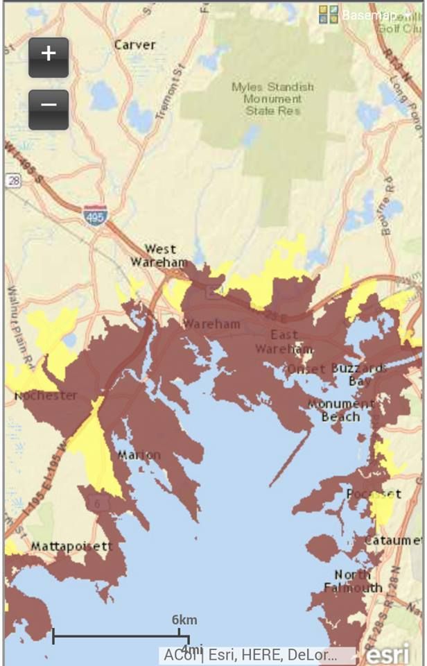
Wareham has a long and lengthy history with ol' Mister Hurricane. Just looking at that map above without knowing what it means, you can see that trouble would be afoot for ?ham if the barometer drops too much.
Wareham has taken beatings from Hurricane Bob, the Long Island Express, and a dozen other storms, and that's just in White Guy history. If you work in the native population, the numbers become countless after an eon or ten.
The 'Ham ( I really want to write a cop show for TV, base it in Onset, and call it "The 'Ham") suffers from the same problem which places like Bangladesh have.... it exists at the tip of a funnel. The funnel is formed by Buzzards Bay. That's the body-of-water Buzzards Bay, not the village part of Bourne... those people share the same Bangladeshian funnel problem that ?ham has.
Hurricanes, with both the wind and storm surge, push water ahead of them. That's actually what the storm surge is. It's not a problem in the middle of the Atlantic, but that water has to come ashore somewhere, and that somewhere is often at what they call the head of the bay. That's Wareham.
In fact, the "where" sound in Wareham may actually refer to "where the water goes." Water cares very little about washing over roads, cars, houses, people.... once it gets off the beach, we have a natural disaster on our hands.
You have two maps here, folks... the upper one shows Inundation, and the lower one shows Evacuation Zones. The maps are from June of 2014, and- to my knowledge- are the plan du jour.
"Inundation" is a nice, painless term that means "covered in water," but you can change it to "Deathflood" or "Sea Plague" if it gets the troops moving quicker.
They (these maps are produced by the National Hurricane Center) assume that Wareham gets a direct hit at high tide, and follow the (groan) SLOSH model of seawater redistribution that MEMA and others use. They are assuming worst case everything insofar as wind direction, phase of moon (check that, they use Mean High Tide), forward speed of the storm and everything else goes.
Those pretty colors are actually differing levels of devastation. I had a map/legend thingy in the Photobucket somewhere, but I'll just say that light green is a Category 1 storm, dark green is a Category 2, yellow is a Category 3, and red is a Category 4.
For a basis of comparison, what Wareham got from Hurricane Gloria may have been a weak Category 1 storm (she came ashore in Connecticut), the Blizzard of '78 was about a strong Category 1/weak Category 2, Hurricane Bob was moderate Category 2 ("moderate" and "Category 2 hurricane" are kind of odd words to string together), old timers may have witnessed Hurricane Carol at Category 3, and The Great New England Hurricane of 1938 was a strong Category 3 made worse (Blue Hills got a 186 mph wind gust) by her forward speed.
The colors show which sort of storm will inundate which areas. Light green means you are hurting in even a weak hurricane. Any shift in colors after light green means that the storm will have to kick it up a notch to reach that area. Red areas are places that will only suffer- but suffer they will- in a Category 4 storm, the likes of which hasn't been seen by White Men in these parts. Hurricane Bob was our 11th deadliest storm ever in Massachusetts, in case you were wondering where your memories rank all-time.
The lower map, Evacuation Zones, is a bit easier to follow. They have three zones of evacuation. The third zone is reserved for storms we don't get, because I never saw the third color, and I looked at 30 town maps. The other colors break down as red = They Have To Leave and yellow = You Have To Leave, Too.
If you stare at the top map a bit an then stare at the bottom map, you'll get the basic idea of the Hows and Whys.
This is a frightening amount of Inundation territory. Wareham is home to 21,000 people. Almost all of them would be underwater in this scenario. To make it worse, these maps only show part of the problem. There will be high winds, downed wires, falling tree limbs, river flooding, sewer overflow, road washouts... you know, the whole nine.
I can leave the worrying to you. It's my job to provide the maps and some insight. My work is done here. Godspeed.