Plymouth floods, no doubt. If you've ever been in Bert's, and wondered why the big boulder was displayed inside.... the Blizzard of '78 put it there. A trip to Cedarville will show you several houses which are one storm away from a straw/camel's back scenario involving the seaside cliffs they rest on. Plymouth was also Ground Zero for the worst hurricane seen in New England by the palefaces, but we'll get to that in a moment.
Plymouth gets mad hurricane Disrespeck for several reasons. One, it is blocked by several barrier beaches, which range from as small as Long Beach to as large as Cape Cod. E/NE winds that push storm unimpeded waves across the mid-Atlantic towards towns like Scituate and Duxbury find a Cape Cod-sized roadblock when aiming at Plymouth.
The Cape, an dat ol' sketchy South Coast, also protect Plymouth from direct hit hurricane shots. Any storm that hits Plymouth has hit New Bedford or Wareham first, and those towns absorb a lot of the initial shock. I watched Hurricane Bob- which tore Cape Cod to shreds- from nearby Duxbury Beach, and the waves didn't even hit the seawall.
Plymouth has a wide variety of coastline designs, or whatever God calls it when He makes Ellisville different from Cedarville. You can park 100 feet from the shore at Bert's and have a wave break over your car. You're a few feet higher off the beach over by Issac's, and you're 8 stories above the waves at the same 33 yard distance if you are working the 18th hole at White Cliffs Country Club.
Plymouth also elevates rather quickly from the shoreline, so the ocean is unable to push that far inland, even with Katrina-style winds blowing behind it. That means very little to you if you live on Water Street, but it is why you don't see flooding miles inland like you do with Duxbury and Marshfield. This is also influenced by the heavily-wooded nature of Plymouth, as opposed to the just-add-ocean marshes in the Floodier towns to the north.
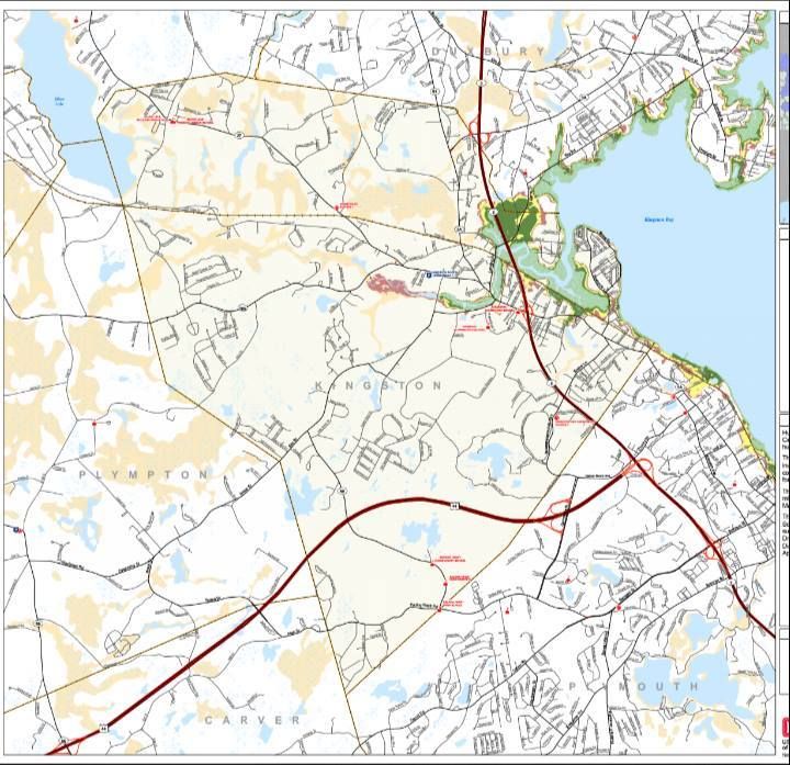
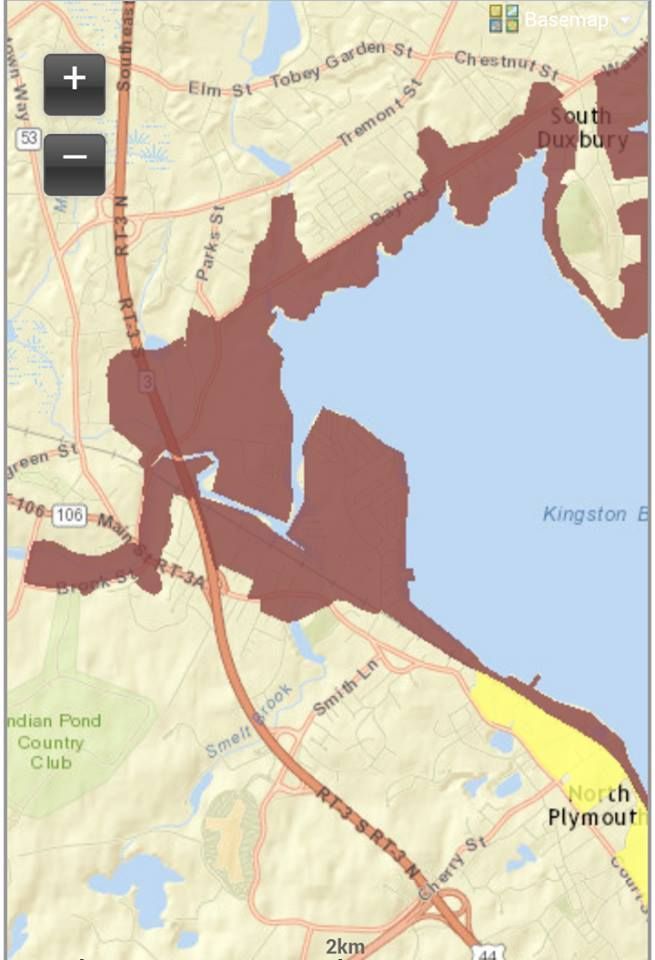
We have two maps for you to look over. The one at the top of the page is a Hurricane Inundation Map. That shows you what parts of Plymouth would flood in what intensity of hurricane. The people who make these maps (a group effort by FEMA, MEMA, NOAA and the NHC) are assuming a worst case, direct-hit scenario with full hurricane conditions striking at mean high tide.
The map DOES NOT account for freshwater, inland flooding. You're on your own there, homie... although you'd want to know how far you are from any river, and the relative elevation of your house. Shoot, 7 inches of rain will sweep some roads away, so be prepared.
The colors of the Inundation map work like this.... light green = Category 1, darker green = Category 2, yellow = Category 3 and red = Category 4. Plymouth has not had direct Category 4 hurricane conditions since the Pilgrims showed up. FEMA even takes a 100 Year Flood estimate for extreme scenarios, which is represented by the color Crayola used to call "flesh" until they realized that minority kids also like to color. I think it's called "Off Whitey" now.
Due to Plymouth's large size, it can be hard to distinguish some of the colors with the picture I have for you. You can solve that by going here. You can zoom in all you want from there.
The hardcore areas in town seem to be a Kingston border-to-Long Beach run. It's not so bad after that, as the hills of the coastline begin to assert themselves. You get some flat coastline- and a river mouth- right where the nuclear power station is. Pilgrim is in the Inundation zone, even for a moderate hurricane. It's odd using terms like "moderate" to describe something as ghastly as a hurricane, but this is how we do at the NWS.
If your street is any color but the white of the map background, you might want to start making plans on escaping. You might have to wait 50 years before you need to get Ghost, but it is better to have a plan and not need it than it is to need a plan and not have it.
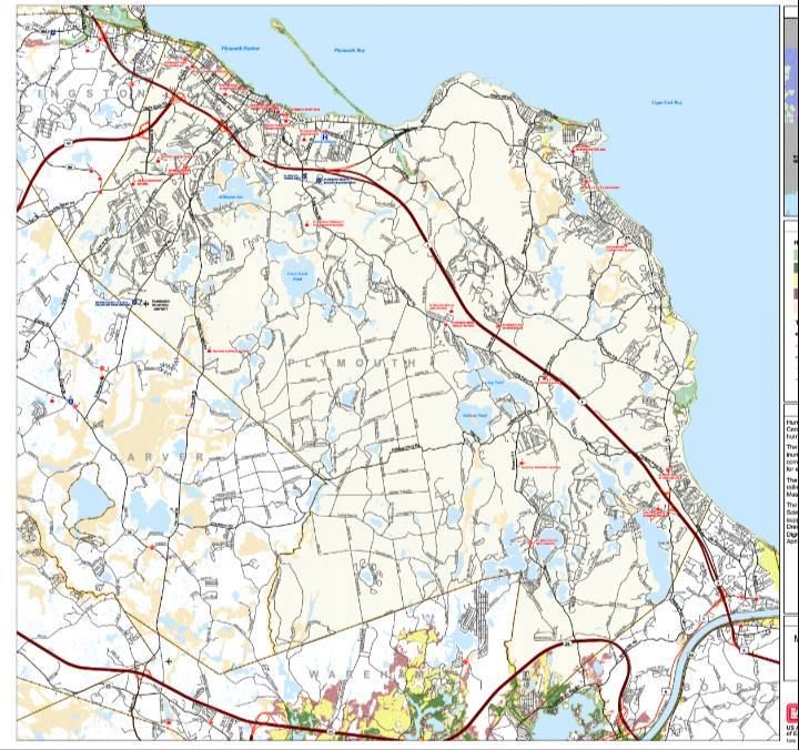
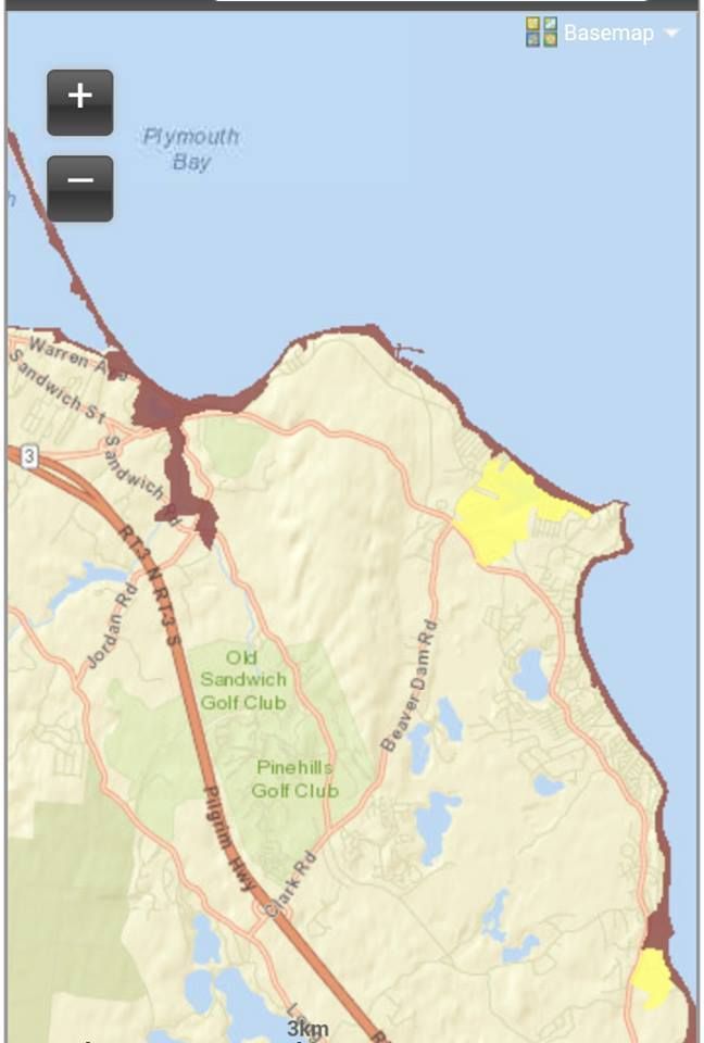
Your plan would be influenced by the second map we have for you today, the Evacuation. Sounds biblical, no?
The proffered Evacution map is easier to follow. Red means "those people have to evacuate," and yellow means "so do you."
Plymouth takes her storm threats very seriously, and the police will be following this map as a guide for which streets and even which houses would be asked to leave when Mr. Hurricane comes knocking.
The immediate shoreline will be evacuated all through the town, even the cliffs areas. This is in effect even for a minimal huuricne. You don't have to leave if you don't want to, but you also don't want to be relying on the cop you told to f*ck off earlier to pull you out of the maelstrom. Irony and Karma both bite for the ass.
The bonus areas in Plymouth that might require inland evacuation are the Eel River area and Ellisville. You have to earn them with a higher-intensity storm, but the threat is real. Larger storms look to be a good bet to evacuate people out to 3A in White Horse Beach and all around the Eel River.
That's the cell phone version of the map, you can view the Evacuation map in more detail by clicking here.
Plymouth folk may have the tendency to disregard hurricane preparations, as they have large land masses taking the heavy shots for them. However, history paints such people as fools, because Harry Cane can f*ck you up smooth in Pilgrim Town. He has before.
Remember, we're only about 380 years removed from the Great Colonial Hurricane.That powerful 1635 storm dropped in unannounced on the Pilgrims, and blew down everything in sight. Experts say that it may have been the worst East Coast hurricane since European colonization, and hit Plymouth (after coming ashore along the CT/RI border) as a Category 3 monster. It may have been Category 5 further south of us.
A storm like that would be bad, bad news for Plymouth, and that would be BEFORE we factored in the inundated nuclear power plant.
Keep your head up, people. This magazine relies heavily on your site visits, and my lifestyle can not afford to have Plymouth residents dying en masse. We've got nothing but love for you.
Saquish, pictured in the background below, would be an island in a hurricane. Rotten last paragraph, I know, but I like to end articles with nature shots.