Showing posts with label hull. Show all posts

Wednesday, May 4, 2016

Examining Wave Attenuation Devices


We're talking Wave Attenuation Devices with Fred Dorr today.

Remember, I'm a sportswriter by trade. My entire expertise on the matter we're discussing today boils down to:

1) I grew up on a beach

2) The house was on a seawall

3) I therefore have a base knowledge of waves-crashing-off-walls

4) Even with no scientific/academic training, I have more experience watching waves hit walls than many people who are authorities on the matter.

It's all downhill from there. My science is awful. I taught Science one year, and the highlight there was when I let the kids handle liquid mercury. I had to throw out and then acquire new versions of 10 school desks.

I mention all this because I'm interviewing someone who works in a field that may spark some interest among coastal residents. This is why I am, from this point on, stealing text wholesale from his website.

Also, I conducted the interview via email. It saves me from taping phone calls like a divorcing couple, and it lets Mr. Dorr speak directly to you, in a sense.

This is also why I am not challenging any of his answers. I'm just showing you some new technology, and you can decide if it will work on Duxbury/Humarock/First Cliff/Horse Neck/Scusset Beach for yourselves.

What is a WAD?

A WAD (Wave Attenuation Device) is a three sided, hollow, concrete pyramid with holes on all three sides and one on the flat top.

WADs do not come in any one size. They are designed according to the conditions at a shoreline site. If, as in the case of Scituate, "they " wanted to deploy WADs at Minot beach, Peggotty, and Humarock, then quite likely there would be three different designs and perhaps three different sizes.

The design and size depend on the conditions at the deployment site. These conditions include ocean bottom, tide heights, astronomical tide heights, storm surges, weather direction, wind speed, storm intensities/frequencies and other factors.
Scituate

The Science of a WAD:

WADs do two things.

First they knock a high wave down to virtually smooth water.

The second thing they do is to remove energy from an ocean swell. They do this much the same way that the aerator on your sink faucet does. If you didn't have that aerator on the faucet the water would come out in a big blast. The aerator only allows the water in the pipe to get to your sink via very small holes. Therefore each of the water streams contains very little energy.

On the ocean side of a WAD array, the turbulent oceanic swells have picked up some sand and carry it in suspension through the WADs.

However, because the WADs reduce the energy of the wave, the sand falls out of suspension and settles on an eroded beach. If there is sand available in the near ocean, if we have a few nor'easter and if we had an array of WADs, we could over a short period of time (1-3 years) have a new dry high tide beach.


Seafood Farming?

In the background are fish havens they resemble WADs except they do not have a flat top or a hole in it.

They are mass produced in three sizes.

They are deployed in small arrays; circles, squares, triangles, etc. They attract fish and promote organic marine growth.

From what I have read they are very effective in increasing a fisherman's catch.


Q)  What makes the WADs better than a conventional Massachusetts seawall (like the Duxbury Beach one in the picture above)?

That's a short question that has a long answer.
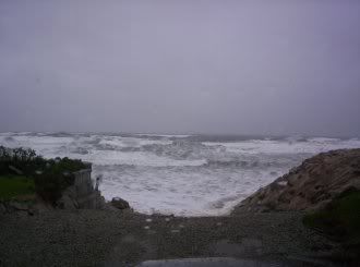
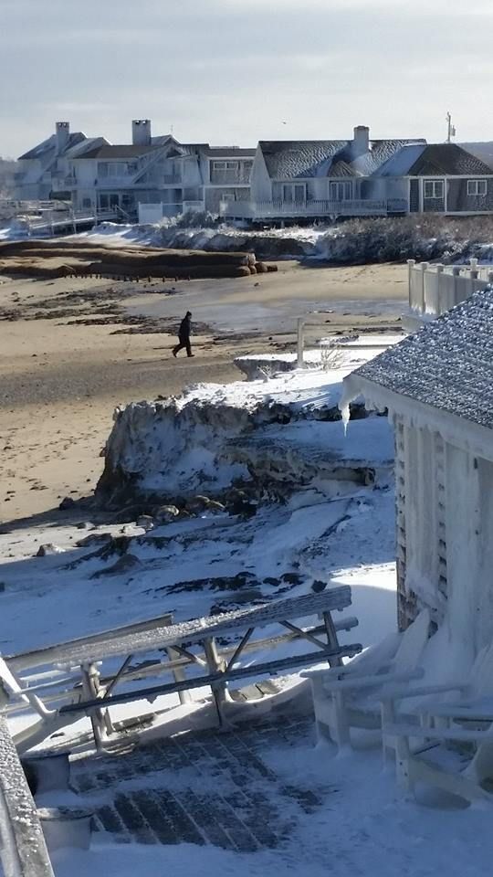
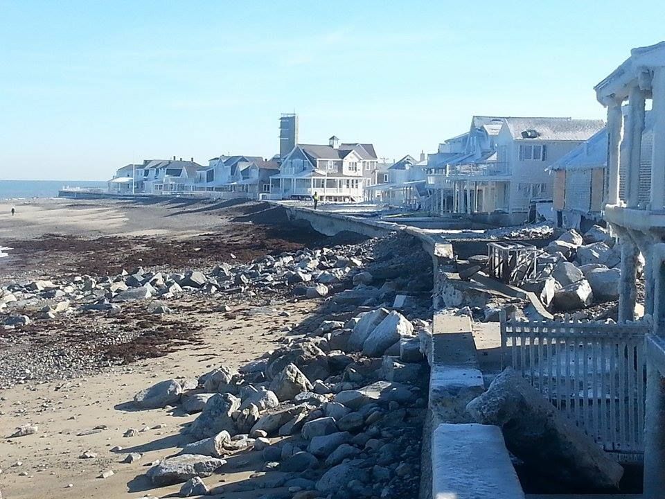
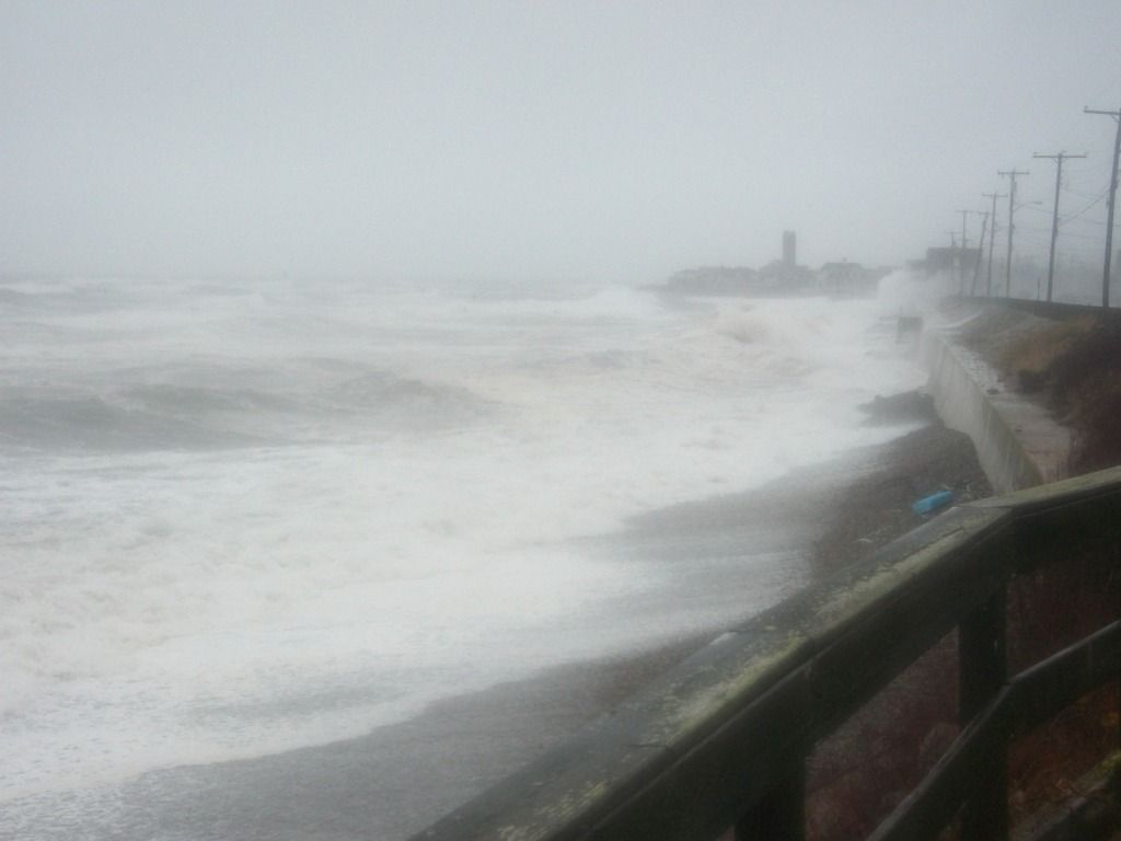
1.  Waves under cut the sandy edge  (TOE) of a seawall
2.  WADs knock down high/tall waves to calm water.  When I asked Scott Bartkowski if WADs could knock down a 20 foot wave his reply was we have killed 29 foot waves.
3.  If there is sand available in the near shore up to 300-500 feet then during storms that sand, with the help of WADs, will migrate to the eroded beach and replenish it.
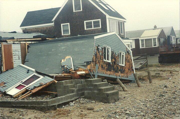
4.  When a beach gets fully replenished, the waves will not reach the seawall.  If a wave cannot reach a seawall there can be no damage to shoreline structures.
Sandwich, MA


Q) How do the WADs not get filled up with sand and stone? Would they be more, less or equally effective when filled or partially-filled with sand and stone?

In the course of doing their work the WADs do not get filled up instead they break the wave energy down into little pieces so to speak and the sand actually moves through the WADs.  If one snap shot were taken of the entire process then you would say that the WADs were filled up with sand.  Go to WADs Work 4 Beaches on face book and look at the video I have posted you will see what I mean.
When a beach is fully replenished then the municipality should get a barge and a crane go out into the sea and move the WADs farther out  and make a larger beach.


What sort of impact-force testing did you do on the WADs, i.e. waves picking up Ottoman-sized boulders (see "Bert's, Plymouth") and throwing them off WADs?

1. When Living Shoreline Solutions does their scientific investigation, they look at what's on the ocean floor, ferocity of storms. storm surge, astronomical tide effect, beach slope and a myriad of other parameters. They design four applicable WADs for a specific beach that will do the job of attenuating "its" waves.   If there are rocks on the ocean floor then the thickness of the wall of the hollow WAD is increased.  Understand that the concrete used is marine grade and reinforced with fiberglass shreds.  As regards to the event at Bert's   I guess my only answer to that is Poo happens.

Ocean Bluff/Brant Rock
Would fish swim into the holes during high tides, get trapped there when the tide went out, and then stink like stank on a hot summer day?  Can you put fish-filters over the holes and not diminish the effectiveness of the WAD?   

There is no need for keep the fish out of the WADs.  The WADS are hollow.  Fish can swim in and out of WADs.  In the gulf coast  LSS makes a series of Fish Havens for commercial fishermen.  They have reported significant increase in their harvest due to the effectiveness of WADS.  WADs are also used to promote oyster growth.


Do you put these WADs where conventional seawalls stand in relation to the high tides, or do they go offshore some?

Duxbury Beach
Generally the WADs are put in the water perhaps fifty to 100 feet beyond the low tide line.  Exactly where depends on a number of factors that are determined by LSS's scientific investigation and the needs of the client.


Is it possible to perform patchwork repairs on WADs somehow?

I am not sure I know what you mean by patchwork repairs.  If you mean to repair a WAD that has been damaged.  I do not know the answer because there have not been any cases of WAD failure in seventeen years.  Caution must be used because the primary market for WADs is in the south and the Caribbean, where there are no rocks.  If you mean can short (25-100 feet) arrays of WADs be put in place.  The answer is yes but the  overall project must contain several arrays because of a cost/profit problem.


This might be silliest question you've ever been asked in this field, but could a town order WADs in different colors if they so desired?

No it is not the silliest but it comes close.  There have been WADs built with rocks imbedded on the top to simulate a nearby breakwater.  I suppose if someone wanted a puse colored WAD array that could be done--at a price of course.

Green Harbor
Do you take any barnacle-prevention measures?  

WADs have three purposes--Attenuate waves, replenish beaches, and provide marine habitat.  I guess that means that if barnacles are going to grow on a WAD the people will have to deal with it.


Do WADs work if the water level gets higher than them?

Extraordinary question.  A swell is essentially rotating water much like a basket ball rolling across a gym floor.  If the bottom of a swell collides with the ocean bottom the swell turns into a breaker.  When a wave breaks it begins to lose its kinetic energy.   Wave height is measured from the bottom of the trough to the top of the swell

Kingston
If an array of WADs is in 12 feet of water and a swell of 13 feet comes by, the bottom of the swell will hit the top of the WAD causing the swell to begin to break.  If the ocean bottom on the beach side of the WAD is less than 13 feet then the swell will really break and lose all its energy.

In the process of losing its energy any sand that was in suspension will be deposited on the beach.  That is like trying to stir a glass of iced tea with five teaspoons of sugar in it.   As long as the tea is being stirred the sugar will stay in suspension.  But, when the stirring is stopped the excess sugar will settle to the bottom of the glass.   That is how a beach is replenished.


What sort of aquaculture can someone perform with a WAD? 

 I know that oysters grow very well on WADs,  I have seen pictures of fish in and around WADs.  In fact two hours after a WAD array was deployed at Negril Jamaica on a barren ocean bottom there were fish "sniffing" around looking for a good place to stay for the night!  I suspect that WADs would make a good hidey place for lobsters


How large of a wave would be required to move a WAD?

The actual answer is no body knows.  In the seventeen years that WADs have been deployed all over the world not one has ever been moved from the place it was deployed.  That is because of its design.  Hollow: water goes through a WAD.  A WAD has slanted sides.  A WAD is a three sided pyramid.  So the water goes up, and through WAD, and can't push it around.
Nantasket Beach
How tall do you make the tallest of your WADs?

All WADs are site specific.  For instance in Scituate, my town.  If the town were to WAD North Scituate Beach, Peggotty and Humarock there would likely be three different designs.  So far WADs have been as short as four feet and as tall as 12 feet.  They have weighed as little as 450 lbs to as much as 21,000 lbs.  I asked Ping Wang PHD University of South Florida who has done some Attenuation testing for Living Shorelines, the following question, "Could a WAD be designed to replenish a beach and at the same time prevent any shoreline damage regardless of the height of the waves.  His very short answer was "YES".


Is one mile of conventional Massachusetts seawall more or less expensive than the same distance of WADs?
Brant Rock/Ocean Bluff


Another fabulous question.  Scituate is or will be building a seawall 700 feet long.  It is expected to cost about $4,000,000 That works out to about $5700 per linear foot.  I have to stop for a moment here.  A seawall is necessary to keep calm high water from flooding the local area.  The concerns of sea level rise can be accommodated with a seawall.  But an array of WADS attenuate the waves.  On the ocean side there might be 12 foot waves.  On the shore side of the WAD deployment the waves might be 6 inches high  The current cost of a double row deployment of WADs is approximately $1,000 per linear foot.  I think that equates to an 80% saving.


Is it possible to buy WADs for personal use like forming a semi-circle in front of your house?

s soon as you said the word "possible" the answer is yes.  BUT you would have to ship them from Florida.  You would not have a choice in shape, because they do not manufacture them in a factory and then ship them from a stock pile.  Living Shoreline Solutions designs a site specific WAD, fabricates the concrete molds in Florida then ships the forms to the site.  Once here local labor assembles the forms and a local concrete company provides the concrete.  Then someone either has to hire a barge with a crane or a very big front end loader to deploy the finished product..  In addition the state owns the water, you would have to get their permission.  From what I understand that takes at least a year.


 I have enclosed two files, which are pictures that I plan to use in the article. One picture is of a seawall in Duxbury, which is what I have in mind when I say "conventional Massachusetts seawall." The other is of the White Cliffs Country Club in the Cedarville section of Plymouth. What could WADs do to stop erosion of those sand cliffs?

I have not yet seen your pix but I know that when it comes to cliff erosion, although WADS have not been used in that particular situation.  I have to add here that no WADs have ever been deployed in the waters of Massachusetts.  I have about 20 years left on this good earth and I intend to use every one of them to get WADs into Massachusetts waters.

Back to your query.  Put WADS in the water the scientifically prescribed distance from the toe of the cliff and if there is sand in the near shore then that sand will be transported to the space between the WADs and the toe of the cliff over some reasonable short period of time.  Perhaps 1-3 years.  In that time the beach level will rise above the height of the WADs and the waves will not reach the toe of the cliff.  If the waves cannot reach the shoreline there can be no further erosion except by the rain.

Again go to WADs Work 4 Beaches in face book look at the five videos for proof that they work.


Saturday, April 9, 2016

April Storm Tide, Final Snow Of Season?


Fans of the stormy weather will enjoy this weekend's entertainment, if they are situated well enough and don't mind staying up all night.

A storm will slide south of New England tonight, and her northern fringe may give the South Coast and Cape Cod a bit of snow. An inch would be the high end figure, and the snow would be more notable for being a strong candidate for the last snow of the year.

April snow isn't that crazy. We've had a blizzard on April Fool's Day, I saw nearly two feet in Worcester on April 28th once, and the Boston record is May 10th.

However, April snow falls at a time when we are tired of winter and looking forward to spring. The last thing a New Englander who doesn't write about weather for a living wants in April is snow.

Again, this storm will mostly precipitate on the fishes, with only the Cape and the extreme South Coast getting any Siberian Marching Powder. Nantucket and the Outer Cape look like the best bet to get enough to make a snowball with.


The South Shore may get left out of the snowfall, but they'll have a shot at some coastal flooding overnight. The storm will produce heavy winds (gusts well over tropical storm force), and they will be coming N/NE at the time of high tide.

Those tides will be very high. Seriously, look:

Duxbury Beach, 1:43 AM, 12.2 feet

Scituate Harbor, 1:52 AM, 11.5 feet

Brant Rock, 1:56 AM, 11.7 feet

Hull Bay, 1:55 AM, 12.2 feet

Manomet Point, 1:40 AM, 12.2 feet

Scusset Beach, 1:44 M, 12.2 feet

Sandwich Town Beach, 1:43 AM, 12.2 feet

Cold Storage Beach (Dennis), 1:46 AM, 12.2 feet

Provincetown, 1:56 AM, 11.8 feet

The storm won't be on us long enough or hard enough (some winds will be more N than the more feared NE) to really tear up the coastline, but splashover tides are bad news in low-lying coastal neighborhoods. When I lived on Duxbury Beach, we used to run the sump pumps 24 hours in a row for a few days during the April high tides, and that was without a storm piling up water onto the shore.

 A 12.2 foot high tide means that, if you stood stock still with your toes at the edge of the water exactly at low tide, you'd be under 12.2 feet of water in the same spot at high tide. The average tide is about 8 or 9 feet, and this waning new moon tide of 12.2 is trouble.

The winds will make a 1-2 foot storm surge on top of all that moon tide stuff, and the worst of it will be along a Hull-to-Bourne-to Orleans run. Let's guess at a Scituate-to-Duxbury epicenter.

Again, never clean up coastal yards until late April at the earliest, Landlubber.

If you live on the coast and are up at that hour, feel free to send us a pic at our Facebook page, we'll maybe do an article Sunday morning if I get out at that wicked time of the night.


We'll also be getting what is presently believed to be the last freezing weather in SE Massachusetts.

This little cold snap has been the result of a polar vortex sending Canada air down to us. As that vortex breaks down, we start getting Oregon air... which doesn't sound that great until you recall the Santa stuff we've been getting every time it snows in April.

From what I see on the Accuweather month-long forecast for Buzzards Bay, there will be no more days where the temperature falls below freezing. When that skim coating of snow on your lawn melts, winter will be over by every conceivable measure.

Look a this way... Opening Day at Fenway is Monday. The Boston Marathon is a week after that. Memorial Day is six weeks after that. Summer is about 3 weeks after that.

You can handle this.


Thursday, March 17, 2016

Check Your Irish


A few notes on the reach of the Irish Riviera....

- Before doing any demographic research, I went to various Facebook pages on the Cape and South Coast, seeing if the people there felt that they should be included in the Irish Riviera.

The Cape people feel that they are a whole other entity. They are correct, IMHO. Cape Cod is actually the New England Riviera. They draw people from all over, where the visitors on the South Shore have a bit more Paddy to them.

No one from the South Coast even replied, to my knowledge.

- As you can see, the heart of the Riviera runs from Hull to Duxbury, with a sizable inland area running to the Bridgewaters. Brockton is a lighter green, but still Irish enough to represent hard.

- You could make an argument about running the Irish Riviera from Plymouth through Bourne down to Falmouth, and maybe hooking it through parts of Sandwich, Barnstable and Mashpee.

- Other than those lonely white dots, you can pretty much roll from the tip of Cape Cod to Worcester on a sea of green.

- Sharon,  a big lonely dot of white in a sea of green in the middle, only has 12% Irish. 14% of their population, and their biggest group by ancestry, is Russian.

- The North Shore has a bit of an inland Riviera going, but it's a B- to the South Shore's 4.0. Her anchorman is North Reading.

- It gets very Latino when you get north and east of Boston. East Boston is 54% Latino.

- The more Irish parts of Cape Cod are about as Irish as the less Irish parts of the South Shore.

- Fairhaven (27% Portuguese), Westport (30% Portagee, 14% French), Dartmouth (37% Portagee), Fall River (44% Portagee) and New Bedford (37% Portuguese, and they have more Sub-Saharan Africans at 8% than Irish at 7%) establish a firm roadblock in front of the Irish Riviera's reach onto the South Coast.

- Onset and East Wareham have the most Micks on the South Coast. while the Popponessett section of the Cape bleeds the greenest. A run from Pop through Hyannis sometimes gets Irish Riviera votes, mostly because of the Kennedys.

- Wellfleet on the Cape and the whole South Coast west of Mattaspoisett need to import some Irish, pronto.

- Even a first grader can look at this map and tell you where everyone fled Southie and JP for when busing started.

- A girl I worked with at AOL is from eastern Massachusetts, and has 4 sisters. Each of them has dated someone named "Murph." Not the same Murph, either.

- You kind of have to squint at it to see it on that map, but Southie is still pretty friggin' Irish. You won't have trouble finding some Irish Spring in Charlestown, either.

- Butter-soft Duxbury is more Irish than any bad-ass part of Boston where Whitey Bulger ever stalked, or at least since busing hit. I don't see any mob movies coming our way, however... although we did have a rapper get shot in town, so there's progress being made.

- Rhode Island is 19% Irish. They are America's most Portuguese state, and also have a pile of Eye-tal-ians.

Happy St. Patrick's Day!!


Sunday, March 13, 2016

The Irish Riviera

Duxbury Beach, courtesy of the Duxbury Beach Residents Association

I grew up on Duxbury Beach, an isolated neighborhood on a peninsula stretching out into Cape Cod Bay.

Duxbury Beach, a cottage neighborhood in the 1970s, was very much unlike Duxbury Proper. As is the case with any isolated kids (during the height of the Baby Boom, my neighborhood had 3 other kids in an area of about a square mile), I was different than the kids in town.

Many people who I went to high school with thought that I was from Marshfield. Others thought that I was "spiritually" from Marshfield, as Vegas villages like Green Harbor and Brant Rock were effectively closer to my home than any Duxbury neighborhood.

People closer to the truth (myself included, for a while) thought instead of a run of "Beach People" stretching from about Quincy to the end of the Cape.

In reality, I was just a citizen of Duxbury's very small chunk of the Irish Riviera.
Hull, courtesy of Nathan McKelvey


We'll be talking Irish Riviera today, to get your mind all proper-like as St. Patrick's Day draws near. We shall explore what a Riviera is, why we have so many Irish, how so many of them ended up on the South Shore and whatever else comes into my head as I bang away at Ol' Momma Keyboard here.

Let's start by discussing what a Riviera is. The famous one is the French Riviera/Cote d'Azur, which is France's coastline on the Mediterranean Sea.

The Cote d'Azur is a resort area. You know how they say that the French all take August off? This is where they go. British, continental and even Russian tourists also started arriving in droves. A 1763 British author wrote of the benefits of oceanfront vacations, and by the end of the 19th century, it was the thing to do.

Originally an aristocracy thing, this newfound (coastal people were generally thought of as a sort of salty hillbilly for much of history) love of seaside resort life soon spread down to the proles.

In the United Kingdom, factories would often close for a week or two in the summer to service and repair the machines. This would loose the workers upon whatever resort areas they could afford to get to. They frequently chose the seaside... maybe get a cottage on the Isle of Wight, if it's not too dear.

This love of seaside resorts definitely bled down to the Irish. Pale and hard-drinking, they were the perfect candidates for the brief two-month-summers of Massachusetts beach life. They just didn't figure it out until they got to America.

Marshfield, thanks to Annaliese Sviokla!
The Irish love America, and the 33 million of them here today equal about 10.5% of the US population. There are more Irish in America than there are Irish in Ireland.

As you probably guessed, most of America's Irish live in California, followed by places like Texas, Florida and Ohio. However, those are just population numbers. When you get to the leaders by % of Population as Irish, your leaders are New York, Pennsylvania and Massachusetts.

Massachusetts takes the title via a robust 21.2% hit of Irish in their population. That's about double the US average. Six of the top ten Irish towns in America are in Massachusetts, and we dominate the top 20, top 30 and top 100 as well.

Milton, MA 38%
Pearl River, NY 38%
Braintree, MA 36%
Collingdale, PA 35%
Marshfield, MA 35%
Scituate, MA 35%
Gloucester City, NJ 34%
Drexel Hill, PA 34%
Pembroke, MA 34%
Weymouth, MA 33%

The numbers are sometimes in dispute, and it depends on who you ask and what your terms are.

47.5 Scituate
46.5 Braintree
45.8 Hull
45.6 Marshfield
44.9 Avon
44.9 Pembroke
44.6 Milton
44.5 Abington
44.3 Whitman
44.2 Hanover
43.4 Weymouth
43.0 Walpole
42.2 Holbrook
41.4 Duxbury
41.2 Norwell
40.8 Hanson
17.4 Boston
23.7 Massachusetts

I'm pretty sure that she's English, but she's posed well
Fieldston (Marshfield) and Squantum (Quincy) sort of trade the title back and forth for Most Irish Neighborhood. Squantum is about 65% Irish, but the difference between Squantum and Fieldston is small enough that the birth of a set of twins or a multiple casualty incident on a road outside of a pub may tip the balance one way or the other.

Most of these Irish started off in Boston. Catholicism was prohibited by the Puritans in Massachusetts, so the Irish were either not coming or pretending to be Scots for a lot of our history.

In the 1820s, various projects like canals, roads and railroads needed cheap labor. Irish immigration skyrocketed. The Great Hunger, where a blight killed off the potatoes which the Irish had come to depend on disproportionately, scattered the Irish like a sort of Mick Pinata.

Two million Irish arrived between 1820 and the US Civil War. They were attracted to cities, where Irish communities were springing up. They were also popular (at least as labor) in any town with a mill. The influx was only slowed by the Great Depression.

More Irish numbers:

Period
Number of immigrants from Ireland

1820-1830 54,338 1911-1920 146,181
1831-1840 207,381 1921-1930 211,234
1841-1850 780,719 1931-1940 10,973
1851-1860 914,119 1941-1950 19,789
1861-1870 435,778 1951-1960 48,362
1871-1880 436,871 1961-1970 32,996
1881-1890 655,482 1971-1980 11,940
1891-1900 388,416 1981-1990 31,969
1901-1910 399,065 1991-2004 62,447

My favorite anti-Irish quote, used completely out of context here... "You will scarcely ever find an Irishman dabbling in counterfeit money, or breaking into houses, or swindling; but if there is any fighting to be done, he is very apt to have a hand in it."

Boston had 35,000 Irish (about 25% of her total population) by 1850. They have banged out 3-7 kids per family ever since. They also got scattered around, as the Irish tend to do.


S'up, girls?
How did the South Shore get so Irish? Were there mills all over Marshfield and Pembroke? When did the Eyes start arriving?

Yes, we did have some mills. There were even fringe industries that attracted Irish, like Irish Mossing in Scituate. Those features brought a lot of Green to SE Massachusetts. You'd also have Irish workers who had earned enough to get out of the city, looking for a more pastoral lifestyle. This was especially true of retiring Boston cops.

After WWII, and with the prosperity following it, many Irish returning from war took the opportunity to head for the sticks. The highway system (especially Route 3, which should probably have an Irish nickname like Mick Street or Paddy Road) provided access to what was already being called the Irish Riviera.

There was yet another Irish Diaspora that grew from the busing era. Any moneyed Mick got the heck out of Dodge when the city started getting ugly. Every town on the South Shore saw their population just about double.

Think I'm lying? Here are the population figures for both 1960 and 1980 for a few South Shore towns, and I could have drawn names from a hat in this region without screwing up my statistical model that much:

Plymouth, 14K to 35K

Duxbury, 4K to 11 K

Marshfield, 6K to 21K

Scituate, 11K to 17K (Scituate reached their Paddy allotment earlier, with the Irish Moss industry)

I'm not saying that the onus of busing involved poor Irish neighborhoods, but you didn't see a lot of people fleeing Wellesley. The South Shore filled with Irish-Am families from Dorchester, South Boston, Charlestown, Hyde Park and so forth. I spent at least one summer as a Dorchester kid living on Duxbury Beach, dating a Boston Latin girl from West Roxbury who summered in Green Harbor. That's straight-up Irish Riviera living, player.

With many South Shore immigrants from Boston, it was just a case where buying and building up a South Shore cottage was cheaper than sending your Irish brood (save the venom, your author is as Irish as a puddle of Guinness vomit outside of Triple O's pub) of 5 kids to private schools from K-12.

Throw in a cycle or two of reproduction, and we are where we stand today.


There is some dispute as to the borders of the Irish Riviera.

New York (Rockaway Beach), Indiana, Michigan and New Jersey all have areas known as the Irish Riviera. However, once you start counting Paddys, Massachusetts can tell all of the other states to start thinking of a new nickname.

The Irish Riviera is generally considered to be the coastal South Shore. Many use a sort of river/tributary system based on Route 3 or especially Route 3A.

Some people include the whole South Shore, as interior towns like Whitman and Pembroke also sport large Mick populations.

Some go the other way, using a Scituate/Marshfield definition. Other people stretch it on to the Cape, to the Kennedy Compound. You still have heavy Irish numbers on Cape Cod, but you should also notice that those % of Irish in a town charts I put up earlier don't have Sandwich, Orleans or Hyannis in them.

I'd personally run the Irish Riviera from Quincy to Sagamore, after which the Cape starts importing tourists and summer people of every stripe to f*ck up the numericals. Bourne is the first town in a long run of coastal Massachusetts towns that doesn't make it onto those % of Irish in population charts, although they are most likely in the 25-35% (Editor's Note: 27%) range.

Besides, the Cape Cod Canal makes for an excellent natural border.


Will the Irish Riviera ever lose her unique, Irish domination of the population base?

There is some gentrification going on. Those cottages that were owned by Irish families for so long get sold now and then. Many of these people are Yuppies, looking to flip a cottage into a coastal McMansion. The Irish make for poor Yuppies.

Many of the Branns and Egans and Carrolls (and even the also-Catholic Italian families like the Leones and Palmieris) from my old neighborhood are still holding out, although the veteran Brann that I spoke to tells me that the neighborhood just ain't the same. The Kerrigans scattered across the world, from Plymouth to Florida to Arizona to San Diego to Australia. Even that Bowden kid is shacked up with a French girl on Cape Cod.

However, it would take some Third World birth rates from other nationalities to knock, say, Scituate down from 35-45% Irish. Since the Catholics frown on birth control, they may even crank out 5 kid families for generations to come. People will still flee Boston. Irish families that grew up summering on the Riviera will move there full-time.

Other Irish families buy up neighboring Riviera houses as the kids marry off, and build little compounds. There is one corner of my old Duxbury Beach neighborhood where you could knock on 3 different doors and still get a Deehan, and tiny Ocean Road North once, in 1999, had 6 houses owned by descendants of the same branch of the Flaherty family.

In the end, we'll end up with a thinned-out-but-still-vital Irish Riviera. You won't beat the Mick out of this area for several generations, if ever.


Thursday, February 25, 2016

Hunting For Sea Glass In Massachusetts


Who doesn't love Sea Glass?

Sea Glass is made when regular glass gets into the ocean. While finding a whole bottle may be preferable, one generally works with shards of broken glass. They wash into the sea, bang around for a few decades, and gradually 1) get the edges rounded off, and 2) acquire a frosted appearance.

Voila! Sea Glass!

The hunter/gatherer of Sea Glass is someone who finds use for a Cape Cod beach in February. Other than aesthetics, beaches aren't really good for much between October and May. You can surf, but that requires the acquisition of a skill, a wetsuit and a car big enough to carry a surfboard. Even then, you have to wait for days where the waves are large, and- even more then- a shark might eat you. Funk that.

You can still saddle up a surfboard, but you can also walk along the shore for free and keep your eyes looking down. You'll eventually gather up a nice pile of colored, frosted glass, which can be used for various artistic projects.

Don't be intimidated by Artistry. I'm pretty much a complete moron with Art (when I was starting out as a teacher, the inescapable chalkboard artwork which I had to perform was of such a low level that one of my students- her name was something like Hillary Aronson, in case you know her- came up to me after a class and said "Mr. B, next time, just tell me what you want drawn on the board and I'll get up and do it for you. Art isn't your strong point."), but even I can buy a jar and put Sea Glass in it. Leave the jar on a windowsill where it can catch some sunlight... boom, Art.

The hunt can be as nice as the meal with Sea Glass, as- even if you strike out- you still get in a nice beach walk. Other than a greatly-increased risk of toe-stubbing, there's really no downside to Sea Glass Collecting.

This is stuff that you probably knew before reading this article, so what I need to do is some lengthy thinkin' on how sea glass is made, and where someone would be best sent to gather some.

As we noted before, the short answer to the How Is Sea Glass Made question is "glass falls in the ocean, et cetera." However, there are a few things that you should know beyond that.

One, there is some snobbery in the game. "Beach Glass" sounds just like sea glass, but it is not the same, and people will clown on you if you think that it is. Beach Glass is either made in rivers or- for the love of Mary- factories. This stuff is the Fat Girl/Poor Man of the artsy glass movement, and a resident of (or a resident with access to) coastal Massachusetts need not worry about it.

Two, sea glass takes 20-30 years to round into shape. You can't smash a bottle today, walk down the beach a few hundred yards tomorrow, and find a frosted version of the bottle you broke. Nope. You have to wait, for decades in some cases. Certain kinds of sea glass (I'm not sure what kinds, I'm assuming thick glass or something) take up to 50 years before they're display-worthy.

In the 1980s or so, they passed numerous Bottle Bill laws, and those empties are worth a nickel each now... nothing to sneeze at when you drink to the degree that I drink, player. People started returning bottles rather than chucking them, and poor folks would eventually gather up any leftover cold-soldiers to make a nickel per. Right around the same time, those tree-huggin' liberals forced many industries to move away from glass bottles towards the non-sea-glass-makin' plastic bottling. While the beer companies held out, even the drinkers picked up some love-thy-planet stuff from the more conscientious people, and are presently less likely to smash bottles when drinking outdoors.

All of the stuff in the previous two paragraphs means that there is less glass being dumped in the ocean, which means that the sea glass talent pool has thinned out substantially. Population growth cancels it out somewhat, but not nearly enough. The person saying "There was more and better seaglass when I was a kid," is correct, not fooled by nostalgia.

Three, the motion of the ocean is important not only for making the glass, but for moving it about. If glass stayed where you broke it, my local pharmacy would have no Noxema, and I'd have a lamp full of cool blue sea glass culled from my just-offshore stash spot. If you're serious about collecting sea glass- and your author is, at least this morning- you have to research where the currents run, where the rivers empty, where the population centers are, seabed sediment redistribution... and numerous other factors, trust me.

Fourth, know that one piece of glass is not of the same value as others. Typical colors include white, brown and green, the colors of the beer and soda bottles. Lesser-known colors include yellow and blue. Experts can look at a piece of glass and tell you what kind of bottle it came from, and from which era.

Basically, clear = beer, faint green = Coca-Cola, darker green = Sprite, and blue means that not only did someone drink Milk Of Magnesia at a beach, but that they enjoyed it so much that they smashed the bottle in celebration when they finished, like Gronk.

Fifth, you need a combination of timing and luck. Sea glass doesn't weigh much, but it weighs a lot more than sand does. Sand washes around more, and eventually will cover up sea glass. There are some tricks you can do to up your odds, but "needle in a haystack" is actually too conservative a measure for what a glass hunter is doing.

If you can go hunting after a storm, do so. Everything gets turned over, and new stuff is cast forth from the sea.

Finally, much like a mating leopard, you have to pick your spots. Location is everything. You need to identify and exploit certain natural features which are distinct to the local geography. That's where we're headed now.

I was just kidding about Gronk smashing Vap-O-Rub bottles at the beach. Most of our sea glass comes from inland flooding. Rivers rise up, find bottles, wash them downstream, smash them up a bit, and send them out of their mouth into open ocean. The lucky pieces make it back to the beach. The coastal people smash bottles too, but their numbers don't match up with everyone inland.

So, your search should start with a river mouth that empties into Cape Cod Bay or the open Atlantic. The North River, the Taunton River, the the Charles River, the Mystic River, the Green Harbor River, and even the Hudson River will spit out glass that you can eventually collect. Glass can wash a long way from where it started.

Once you have that part done, you have to look at currents. Currents wash the glass to wherever it is going to end up... well, currents and waves, of course. You need to imagine the glass washing into the sea and being directed somewhere by the local currents... currents which, thanks to this handy map, you are now familiar with.

So, you have a glass source, the general direction from the source where the glass went, and now you need to guess where it ended up. This is where I have to invent a geographical term. A "basin beach" is something that sticks out into the sea a bit and collects whatever floatsam and jetsam the sea has to offer. Think of the basin beach as being a big first baseman's mitt, working the current.

Once you're on that beach, look for the area where everything washes up. If a beach has a sandy part and a rocky part, go to the rocky part. Work the fringes of the pile, or go All In and start digging in the rockpile itself.

I actually suck at the collecting, myself. I'm a tall man, and I have terrible eyesight. That's a bad combo to call in on a job where you are looking for tiny bits of glass on a beach, and that's before you factor in the ADHD and the often copious drug usage. What I am good for is helping you skip some of those steps I listed by pointing out local beaches which fit the criteria for a sea glass hot-spot.

Horse Neck Beach, Westport

The Gulf Stream current pushes right up into the body of water known as Buzzards Bay. America's east coast most certainly coughs up a lot of sea glass. Most of it goes out to sea, some of it ends up on Lon-Guy-Land, Rhodey takes her share, but that still leaves a lot of Niceness washing into Bee Bay.

Horse Neck Beach (do not buy into rumors that it was named that because a harlot was lynched there) is well-positioned to get a cut of that action. I suppose that a lot of New York glass washes over here, which should help your numbers out some with ol' Lady Luck.

HNB is also close enough and yet far enough to/from the Taunton River to guarantee a nice flow of glass.

More glass probably goes to the Elizabeth Islands, but mining that involves you getting a boat and stuff. Remember, you're putting broken glass in a jar... let's not ring up any silly expenses.

Speaking of which, the two best spots to capitalize on the Gulf Stream current- Nantucket and Martha's Vineyard- are also eliminated for needs-a-boat reasons.


Old Silver Beach, Falmouth MA


On the other side of Buzzards Bay, we have the town of Falmouth. In the town of Falmouth, we have Old Silver Beach.

I like more rocks on a beach when I hunt, but OSB is very well positioned to get washashore sea glass. If you can get up by Crow Point, do so. It's rockier there.

You may end up in someone's front yard, so be careful. I grew up on a beach and live on one now, so I tend to be a bit unaware of beach restrictions in other towns.

If you find some silver there, even better. Just don't be, like, taking it out of people's beach houses or anything, friends.


Craigville Beach, Centerville MA

Cape Cod, which is a barrier beach for Massachusetts, is also protected by a pair of barrier islands known as Martha's Vineyard and Nantucket, as well as the Elizabeth Islands. These islands, and the multitude of jetties and groynes along the coast (Dennis Port has so many groynes and jetties along the shoreline, it looks like a zipper when viewed from space) interfere with the glass gathering process.

The islands, at a sharp corner of the Gulf Stream, also have odd currents. They sink ships, which is why they dug the Cape Cod Canal. It also messes with the sea glass distribution.

Even if they don't stop the flow of sea glass entirely, the process becomes somewhat unpredictable. We'll give you a southern Cape location to check, but don't say that we didn't warn you.

Craigville sits in a gap between Martha and ACK, and is a nice base from which to operate. She is also basin-shaped, which should act like a catcher's mitt and trap seaglass.

Remember, since you aren't too far from the Kennedy Compound, you might get some high-pedigree glass. I know a guy who lives near Chappaquidick who claims to have red sea glass from Ted Kennedy's brake lights.

Friggin' sweet stopper!

Coast Guard Beach, Eastham, MA

Cape Cod is several different beasts as far as sea glass collecting goes. Buzzards Bay is well-positioned, while the south-facing Cape isn't. Once you turn the corner at Chatham, however, it's a whole new ball game.

I like east-facing Atlantic beaches. A very determined piece of European or African sea glass may have fought her way to America against the Gulf Stream. Who knows? It may have once been Queen Isabella's compact, or Napoleon's Courvoisier bottle, or John Bonham's headlights, or Idi Amin's coke mirror. You never know, stuff like that gets tossed around all the time.

Park and walk north (left) once you hit the beach, to get yourself past the sandbars.


Race Point, Provincetown, MA

RP is one of those gold mine spots. She's also the first beach on our list that isn't getting Gulf Stream in her mix. Most of her sea glass is coming from the north.

People who study currents are already saying "By George! The West Maine Coastal Current aims right at Race Point!" You can't sneak anything up on those people. RP gets stuff from Maine and New Hampshire all the time, including sea glass.Throw in whatever Boston glass washes out that far, and you have a hot spot.

Stellwagen Bank also channels stuff towards Race Point. Note that the Bank, and Cape Cod to a greater extent, slow down waves. This slows down sea glass migration.


Skaket Beach, Orleans, MA

I knew that my kung-fu was superb when my research on which beaches to hit led to a list which matched up with the Sea Glass Ninja Lady from Cape Cast. She admitted that she had no idea why one beach or another yielded better results, but our conclusions match up well.

Inner Cape Cod Bay is a tremendous place to go. It acts as a catch basin for the runoff from the Western Maine Coastal Current. This current is the engine that drives Cape Cod Bay's sea glass movement. Water is pushed along the shore from Maine, past Boston, and into Cape Cod Bay. The fish-hook shape of Cape Cod helps catch the glass as it moves down the line.


Sandy Neck Beach, Barnstable MA

Sandy Neck Beach is a rather long beach, so if you strike out here, you might want to look for easier-spotted things as your next hobby. I'd recommend Lighthouses, it's tough to miss those.

Sandy Neck Beach is a 4700 acre barrier beach, and she is what everything that washes down from Boston eventually bumps into.

You can double up on Sandy Neck Beach. It's where the sand that washes down from Sandwich ends up. Added bonus... when they dredge the Canal, they dump the fill on a beach just west of SNB, and it washes East during storms. Go to Sandy Neck after a full-moon storm, you'll get a lot of Sandwich's sea glass as well.


Scusset Beach, Sandwich MA

The South Shore ends with a THUD as you hit the Scusset Beach jetty. They made the jetty to protect the Canal, but they may as well have made it to catch sea glass.

If Sandwich is being robbed of sea glass, that means someone else is getting extra! Ironically as Hell, I think that this was Mr. Glass' motivation in Unbreakable.

If you want to throw some sand over the jetty towards Sandwich, they'd appreciate it.


Manomet Point, Plymouth MA

P-Diddy is somewhat sheltered by Duxbury Beach, and Manomet Point is the part of Plymouth that sticks out the most into the sea. If you follow the current down the South Shore, MP is what you'll eventually run into.

You're not too far downstream from an oceanfront nuclear reactor here, which in theory would make it possible to look for glowing, irradiated sea glass at night.

If you want to be up the river from the plutonium, try the perfect-for-the-job Long Beach part of town.


Duxbury Beach, Duxbury MA

Duxbury Beach is pretty much the exact shape of the Western Maine Coastal Current, and the current repays the favor by giving Duxbury 5 miles of sea glass hunting territory. Nothing on the South Shore sticks further out into the current than Duxbury Beach does.

You get another 5 miles on the bayside, but the big scores are on the oceanside.

Once you commit, you may as well walk down to the uninhabited part. Less people have worked the territory, upping your chances of scoring big.

If you feel really ambitious, dig into one of the huge rockpiles around the crossovers The good stuff is under the rockpile.

Since I am a former Mayor of Duxbury Beach, you have to give me 10% of your haul, or half of any blue glass.


Egypt Beach, Scituate MA

You'll feel like King Tut after you pillage Egypt Beach, wocka wocka wocka...

Scituate has several beach styles, including rocky, sandy, and marshy. Egypt Beach is what Goldilocks would settle on after dissing the other beaches in town for one sea glass-huntin' reason or another.

You can dig in the rockpiles, or you can walk along the perimeter and pick off the strays. It's Scituariffic!


Nantasket Beach, Hull MA

We saved the best for last!

Nantasket represents two things here. She is the end of the South Shore gold mine, and she is where the WMCC loses her power. That's the bad news. Everything else is good news.

Nanny may hold the title for the region, as she is perfectly positioned to get Boston's glass. She also gets the inland glass, when the Charles and Mystic Rivers spit their bounty out into the sea.

Point Allerton is probably a better spot, but Nantasket is more accessible. The area around the high school is productive, as well.


Much love to Julie Nightingale for the sea glass pics. Sara Flynn gave us the Duxbury Beach shot with the stairs. Jessica Allen was nice enough to shoot Hull for us.

Thursday, February 18, 2016

Marsh Madness: The South Shore Coastal Flooding Championship


Our aim today is to rank the beaches of Southeastern Massachusetts for Coastal Flooding Vulnerability.

There are several things that you should know before you dive into this pool. For starters, this is the second time that I have written this article. The first time I wrote it, just explaining the rubric I'll be using took about 15000 words, and that was before I even started ranking the towns. Jessica had the fine idea of working the rubric into the town descriptions as I rank them, and that seems like a pretty good space-saver.

Secondlyish, remember that our major flood risk on the South Shore comes from nor'easters. If you add hurricanes to the list, it suddenly becomes Cape Cod and South Coast-dominated.

Also, know that there is no clear winner for this. Duxbury, Scituate and Marshfield can all make a legitimate claim on the top spot. Duxbury Beach, parts of which are severed from the rest of Massachusetts now and then, has the worst conditions (we'll explain in a minute), but the other two towns have heavily populated shorelines.

Because of that, we're going to sort of group towns of varying threat levels. More on that in a sec...

We're not claiming the title for the state. The North Shore is also a stormy place. We're just gonna leave those beaches for some North Shore blogger. While we plan to annex Bourne and Sandwich for this discussion, they'll go back to the Cape for the Barnstable County version of this article.

Finally, know that we are using town-by-town rankings. There are many good reasons to break things up neighborhood-by-neighborhood. Great and potentially dangerous differences exist between how Duxbury Beach suffers in a storm and how Duxbury's Powder Point neighborhood fares.

However, going by neighborhood would give us a boring Top 10 of Duxbury Beach, 4 Marshfield neighborhoods and 5 Scituate ones. Also, if you think this article is long, imagine one where I have to differentiate between maybe 35 different beaches in a dozen towns.

Ranking-by-town takes the onus off of your author, who grew up on one beach and is an expert on that one beach, and instead will let residents of various neighborhoods fight it out in the comments section about whether Peggotty Beach gets it worse than Minot does.


RANKINGS

Again, the rubric I use would take all day to explain.

Highlights include beach length/width, population, past damage, loss of life, barrier beaches, behind-the-beach wetlands, orientation, development, wind direction, storm strength, latitude, longitude, offshore rock formations, jetties, groynes, currents, dual frontage, property values, media coverage, breaching, erosion, sand dunes... you know, the whole nine.

I've put as much thought into this as anyone has, and it seems like you can break the beaches up along three threat levels. Major, Moderate and Minor.

They go a little something like this:

- If your waterfront house doesn't need a seawall, you're Minor.

- If your waterfront house has some flooding issues, you're Moderate.

- If you stand a chance of being killed in your waterfront house (during a storm, of course)... Major.

I'm resisting the urge to try some Foxworthian "If a live fish has ever washed into your house, you might be in a Major coastal flooding community" jokes. You're welcome.

We realize that Minor, Moderate and Major are boring, so feel free to use some other more amusing trinity if it pleases you. Parish/Bird/McHale, Original/Extra Crispy/Grilled, Stink/Stank/Stunk... whatever you're into, people.

MINOR

KINGSTON

Kingston enjoys a cushy spot on the South Shore, tucked into a cove and sheltered by three barrier beaches. Two of these barrier beaches- Duxbury Beach and Long Beach- are small. The other one- Cape Cod- is not.

Kingston can suffer storm damage, but it will always be exponentially smaller than damage suffered by her barrier beaches.

Kingston is by far the southernmost town on the Mild list. Almost all of the other Mild towns are sheltered by Hull. Kingston stands alone here.

To be fair to Kingston, part of the decision to have her be last in the rankings is that she is the Mild town for which I have the coolest picture.


WEYMOUTH

Weymouth has an itty-bitty shoreline, hidden behind the blind side protector that is Hull.

She may even hold the very bottom ranking, except that she has the Fore River,and that can amplify flooding a bit.

One wonders if the Fore River was named by a golfer. If the Blues Brothers movie was set in Massachusetts, Elwood would have almost certainly jumped the Fore River drawbridge while Jake was throwing the cigarette lighter out the window.

Via the Fore River, she exemplifies the vibe you'll see several times on the Mild list... she doesn't have much trouble, but when she has trouble, it's Big trouble.


HINGHAM

Weymouth stands behind Hull. Hingham, on the other hand, is literally hiding in Hull's skirt. Aliens viewing Massachusetts from space would think that Hull was built to protect Hingham.

Hingham is on a bay, so there is some flood risk, but it is minor when compared to what would happen to a Brant Rock or Town Neck Beach during the same storm. She's far enough north that some storms miss her entirely.

Hingham looks very much like a t-shirt when viewed on a roughly-drawn political map. I just wanted that on the Internet somewhere.

Hingham's flood risk is low enough that, as you can tell, I shot my Hingham photograph while zipping through Hingham at 45 MPH on my way to Nantasket or somethin'.

QUINCY
Not Quincy (it's Green Harbor), but Quincy has shoreline, trust me)

Quincy is a unique fish, in that if you draw straight line X from Weymouth's coastal border with Quincy to Boston's coastal border with Quincy, you'd use about one third of the ink that you'd need to use to draw the actual X-times-three twisted shoreline that Quincy claims between Boston and Weymouth

Quincy has a pincer-shaped coastline that funnels water towards the middle, a much milder version of Bangladesh. The pincers are made of heavily-populated areas.

Why aren't they in the Moderate group?

Quincy is a sheltered bay town. She has Hull and, to a lesser extent, Winthrop blocking for her. She also has Boston Harbor islands which break up the surf somewhat. She's the northernmost town on this list, which means that storms which clip the South Shore with their northern fringe may not touch Quincy.

Quincy also came up on the losing end of the "Should densely-populated Quincy be scored more for moderate storm damage than southern Duxbury Beach (population: zero) is for worse damage?" argument that the authors had while constructing our rubric.


COHASSET

Cohasset is the least likely town to be on the Mild list when you're looking at a map. She has plenty of shoreline, has no barrier beach in front of it, and claims coastal-flooding heavyweight Scituate as her next-door neighbor.

Cohasset "loses" on intangibles. She has a rocky shoreline ("Cohasset" is bad Algonquian for "long rocky place"), Ledges and rocks/rockpiles lay offshore, breaking up waves. Although she's considered South Shore, her northern border lays about on the same longitude as Boston. That keeps her off the fringes of a lot of storms.

Cohasset even sits higher than her neighbors do, usually on a bunch of rocks. She has a more Northerly bearing than Scituate does, which means that she is most vulnerable to the lesser storm winds.

Cohasset comes up with the short straw when arguing about "Should a town where some 5th generation slacker who is barely holding on to his damaged Humarock cottage be scored worse than a wealthier town where homeowners who suffer damage just go to one of their other houses?"

MODERATE

BOURNE

Bourne and Sandwich are being borrowed from Cape Cod for this article, because they each have unique coastal flooding characteristics that will come in handy when describing Massachusetts coastal flooding scenarios.

For starters, Bourne is the only town which has Canal Flooding as a factor in her own personal rubric. Canal flooding seems silly, until you talk to people who were alive in 1938 and recall houses washing down the Cape Cod Canal with families inside trying to claw their way out of the attic ceiling.

Bourne, which doesn't suffer major nor'easter damage when compared to a place like Duxbury Beach, does have the unique distinction of being the only town in Massachusetts which touches both Cape Cod Bay and (the body of water) Buzzards Bay. That exposes them to both nor'easter damage and hurricane damage.

Remember, a two-front war is what did Hitler in. Bourne has been Poseidon's punching bag many times before. Heavyweights on this list like Duxbury and Scituate were barely touched by Hurricane Bob, while Bourne was torn to shreds.

When we start mixing hurricane damage vulnerability into the rubric, Bourne jumps up from Moderate to Major and shoves aside Duxbury and Scituate to claim the top ranking. In that regard, they may even be in a class by themselves.

However, the mojo of these rankings is more Nor'easter, and this drops Bourne down a weight class.

SANDWICH


Sammich also has a problem with coastal flooding that could, eventually, push her into the top part of the rankings.

The Cape Cod Canal, which helps everyone out, requires a huge jetty at the Cape Cod Bay end to keep sand from washing into the Canal and beaching ships. The idea works so well that Sandwich beaches are suffering Sand Depletion. This occurs when sand that would normally wash down the South Shore and replenish Sandwich beaches instead fails to get around the jetty and subsequently makes Scusset Beach very nice.

The problem is compounded when ol' Mr. Storm comes along and washes the Sand out of Sandwich. I don't even know where it ends up, but it's never good when your Sandwich gets smaller every high tide.

The process works in such a manner that even simple logic- use the sand that you dig out of the Canal when you dredge it to replenish Sandwich beaches- is foiled when the storms wash all of the new (to them, anyhow) sand away.

The Scusset jetty also takes away the ability to build jetties in Sandwich... you can't trap sand that isn't coming, even if you have Sand in your name. I'm told that this is why the Sandman lives inland.

This is a Major list sort of problem, but Sandwich is also has Cape Cod blocking her NE wind waves. She does get pounded by nor'easters, but generally it is the latter, north-wind sections of them. Much like Bourne, this knocks them down a letter grade.

To be fair to Sammich, note that they fit my listed condition (no seawall) for Minor status, but their unique problem with shifting sands moves them up a tax bracket. It is tough to keep them out of Major, but Moderate is where they stand.


HULL

H-U-Double-Hockeysticks has it all on paper. They are the barrier beach for Hingham, Weymouth, Quincy and even Boston. They are thrust out into the sea like some strange and sandy phallus. They take big hits from the ocean, and are close enough to Boston to possibly enjoy a bigger storm reputation.

I give them extra points for having one road out of town, and even more points for the ability of that road out to be flooded over in spots.

Hull appears very much like God wanted this section of the Massachusetts coast to have bookends, as Hull looks sort of like an inverted version of coastal flooding heavyweight Duxbury Beach.

Hull has three factors keeping them in Moderate status.

First, they are very rocky.

Second, they enjoy relatively high elevation above sea level in some of the more vulnerable spots.

Third, they are far enough north that they miss some of the fringe coastal storm action.

They do have, to my knowledge, the best football field in Massachusetts (and, therefore, probably the world) to watch a game at during a nor'easter.


PLYMOUTH

America's Hometown is huge, and has a shipload of coastline. It was large enough in 1620 that the Pilgrims managed to hit it sailing from Europe.

They have Cape Cod blocking for it, and that saves them a lot of storm damage. That's why they're in the Moderate category, player. If you want to know how much wind and wave damage you gain or lose by having Cape Cod between you and an ocean storm, the difference is about Scituate vs. Plymouth.

A good section of town (and a major business district) is protected by a lengthy barrier beach and an intricately designed jetty. The rest of the town is guarded by more jetties, groynes and so forth.

They do have some problems.  I spent most of my Physics class in high school looking at legs, but I did face the chalkboard enough to pick up that Potential vs Kinetic energy stuff. Cedarville has a few dozen houses perched on sand cliffs 100 feet above the ocean. The ocean, even with a Hawaii 5-0-style tsunami wave that would kill 100000 Indonesians, can't touch these houses... yet.

Storms only damage sand and beach grass right now on Cedarville, but I would be very, very remiss if I failed to gauge the "sand cliffs slowly erode, and houses set on them will some day plunge 100 feet straight down into the ocean" factor into my judgement.

Plymouth is also the only town in the region with a "I wonder if the coastal flooding will reach our oceanfront nuclear reactor?" problem.

Note that Gurnet Point/Saquish are part of Plymouth politically, but they are geographically part of Duxbury Beach. This classification by the editor (Hi!) lowers Plymouth's rating while not raising Duxbury's.

MAJOR

MARSHFIELD

Marsh Vegas, Deluxbury and Skitchate are sort of 1A 1B and 1C in our rankings. You can make an argument about top rank for any of them, and against any of them. If you demand a numerical ranking, I'd give Marshfield #3. The gap between #3 and #4 is substantial, however. The gap between #3 and #1? Not so huge.

You may have seen Marshfield in action on the TV set during last year's blizzard(s), which tore through the seawall and wrecked a few houses. That's the kind of action that breaks apart the Moderates and the Majors.

Marshfield has 5 miles of coastline, some of which (Rexhame) serves as a barrier beach for other parts of the town. Sexy Rexy is also one of two Moraines (glacial deposits of sand and stone laid out in a straight line or something) on the East Coast that serve as a barrier beach. Marshfield, which deserves it, has the most Jetty action on the South Shore, to my knowledge... although I think that Plymouth has the biggest individual jetty down by Issac's.

Marshfield has it all, a perfect town with which to lead off the Major part of the rankings. Direct northeast frontage? Check. Far enough north that Cape Cod doesn't block for it, but far enough south that storms hit it? Check. Heavily populated immediate shoreline? Marsh Vegas is jammed along the coast.

Every beach in town (Rexhame, Fieldston, Sunrise, Ocean Bluff, Brant Rock, Blackman's Point, Blue Fish Cove, Burke's and Green Harbor... if Wikipedia missed one, let me know in the comments) has been smashed by surf. They are even drawing TV news crews away from Scituate, which is important because Media Swagger matters to me when I do the rankings.

What keeps them from owning the top spot outright? For one, the worst flooding you see in Vegas (the Esplanade area, home to the former Arthur & Pat's) is splashover. Up until last winter, I had 40+ years of living in that area where seeing a house get wrecked was a rare event.

The shifting of the sands (Marshfield beaches are fed by the erosion of Scituate's sand cliffs, and replenishment has been blocked somewhat by the storm-breaking jetty system Marsh Vegas employs) has left Marshfield with higher-than-average seawalls. This helps, in that it takes larger waves to get over it, and hurts, in that the base of the seawall can be exposed. This leads to- as we saw last winter- catastrophic seawall failure.

Still, Vegas is nothing but Major. Don't you worry... anyone who says otherwise has to fight me first. Unfortunately, the "don't you worry" part also is intended for whoever has to fight me. I'm a big softy.


SCITUATE

"Scituate" would be almost everyone's immediate answer for the "Who gets the worst coastal flooding conditions?" question.

Scituate owns the news coverage for nor'easters. I bet that Shelby Scott still has nightmares based in Scituate. The sea screams out of every picture you take along the coastline. The town name even looks nautical, dog. To the seasoned observer, however, this coverage is why the Scitty By The Sea doesn't have the top spot... the news crews can get to Scituate in a storm.

More than one person (or maybe it was just me doing it more than once) has noted that only the Irish and Italians have the Catholic tendency for self-punishment necessary to build their Irish Riviera right smack in the middle of Nor'easter Alley. I'm as Mick as a Sinn Fein holiday party, and I actually look forward to these storms.

Scituate (and Marshfield to a lesser extent) was never even considered for anything but Major status. People have- allow me the use of the double adverb relatively recently- died in Scituate during coastal storms. If you buy a house in Scituate, and if a storm wrecks it, people will look at you like you're a damned fool if you complain about it. "Seriously, guy... what did you think was gonna happen?"

I actually went to Scituate's Facebook page to try to get the residents fighting each other over which beach in town gets beaten up the worst in storms, but I posted at a bad news time and got little action on the matter.

Scituate has a lot of coastline, and much of it precarious. Humarock, which  lot of people think is part of Marshfield, is actually a part of Scituate that was split off from Scin Scity by the Portland Gale of 1898, a storm which actually shifted the mouth of the North River.

Other parts of town (Minot, Peggotty Beach, etc...) may ring a bell with you, mostly from local news nor'easter coverage. They all get punished during even minor nor'easters like they were kids from an Adrian Peterson/Joan Crawford tryst.

Either way, if you make your own list and have Scituate at the top, I really wouldn't argue that much with you. She has earned every one of her stripes.


DUXBURY
Photo from the girl who used to own The Fairview, I forget her name...
Duxbury owns the #1 spot. The short answer as to "Why?" would be "Look at it on Google Maps."

However, if a Scituate or even Marshfield supporter came to me and said "I think that the rankings should be more biased towards towns with heavily populated shorelines," I'd tell them that "You would then need to put Scituate or Marshfield at #1 and maybe drop Duxbury down to Moderate."

Duxbury has several factors that otherwise make her the worst spot in Massachusetts for coastal flooding.

- Duxbury Beach gets torn from the mainland a lot. She is presently attached to the mainland only because a convoy of about 100 trucks a day for 6 months dumped sand to fill in the beach breach that went down during the Halloween Gale.

- Duxbury has a 6 mile barrier beach which suffers ridiculous damage, but much of the remainder of the town is also exposed to coastal flooding... albeit of a far lesser ferocity. Duxbury's coastline after/inside of the barrier beach suffers Hingham-style storm damage. Shes the only town on the South Shore to get interior coastal flooding a mile or more back from the barrier beach.

- There is about one (1) patch of trees on Duxbury Beach with which to moderate storm winds.

- Duxbury has a very short seawall when compared to Marshfield. Duxbury gets all the sand that washes out from under Green Harbor's seawall. You can step off of Duxbury's seawall without breaking stride now and then, and even the highest height that the seawall gets from the beach is about half of the lowest height that you'll see in Marsh Vegas.

- Duxbury Beach has a giant marsh behind it. Since many storms hit during a full or new moon tide, this means that Duxbury Beach lays between a mile of flooded marsh and the fury of the angry Atlantic. Duxbury Beach neighborhoods often flood during full moon tides even without storms.

- Because of that marsh, Duxbury Beach becomes an island with a height of about 3-5 feet above sea level before the storms hit it during full moon tides. Water pushes in on the narrow beach from both front and back. This island, again because of the marsh flooding, is about a mile out to sea.

- The roads in and out of Duxbury Beach wash over from the marsh well before high tide, with or without storms. If you're not out of Duxbury Beach by an hour before high tide, you're pretty much there for the day.

- Waves break on houses during storms, something you don't see (those shots of Scituate on the news are spray) a lot in non-hurricane communities.

- Duxbury is the first town on the South Shore (as well as the first town of the Big Three) to not enjoy protection from Cape Cod as a barrier beach. The wind seems to both sense and resent this status, and it hits Duxbury with monster truck force. This status is such that, if the wind is more southeast than east, the title shifts to Marshfield.

- Duxbury Beach has 6 miles of shoreline (plus, since she's a peninsula, 6 more of almost open-ocean bayside coast). About a third of a mile of that oceanfront has any sort of seawall in front of it. As we said, that seawall is about as low as they get on the South Shore, at least of the Army Corps Of Engineers variety. Even the section of the beach with the seawall gets catastrophic damage during storms. When you go beyond the seawall, it gets worse.

- Because of this tendency towards damage, they stopped trying to build any sort of cottages out there a long time ago. Duxbury Beach is prone to Galveston-style overwash in strong storms. Only a fool would build beyond the seawall.

- Because of that, Duxbury Beach has a limbo-under-a-schnauzer low population. I was one of four (4) kids in a 5 mile stretch of land when I was growing up there.

- That Peggotty Beach cottage (the one on stilts) picture I used for the Scituate section of this article? That house wouldn't be standing on Duxbury Beach. Duxbury lost their last no-seawall-in-front-of-them cottages in the Blizzard of '78, and they were already husks for decades by that point. Scituate, if you drive through it, is full of that 1950s cottage style that has long since been destroyed and rebuilt differently in Duxbury.

- This author puts Gurnet Point and Saquish into the Duxbury category, even though they are part of Plymouth. If you ever get a chance to view Gurnet Point, know that this terribly exposed area is actually the high ground on Duxbury Beach... and by a large margin. Saquish was most likely an island when the Pilgrims arrived.

- The reason you don't see Duxbury on the news during storms is because it is impossible to get a news van in and out of Duxbury Beach for a half dozen hours or so during a storm events. You almost have to wait for low tide to leave in some instances. A morning news crew sent to Duxbury Beach for a storm wouldn't get back to Boston until the evening news broadcast was happening.

- My brother used to manage Avalon, and we had a piece of Avalon's old dance floor in my Ocean Road North cellar prior to the Halloween Gale. It actually washed out of the house during the Gale, and we later found it 5 miles across Duxbury Bay, by Sweetser's.

- No one less than the National Guard will prevent you from entering Duxbury Beach during bad storms. They will also intercept, buy and eat any pizzas you try to get delivered into Duxbury Beach during a storm, as we found out during the Halloween Gale.


Anyhow, those are the rankings. Questions? Appreciation? Hate? Differing opinions? That's what the Comments feature is for. Use it.