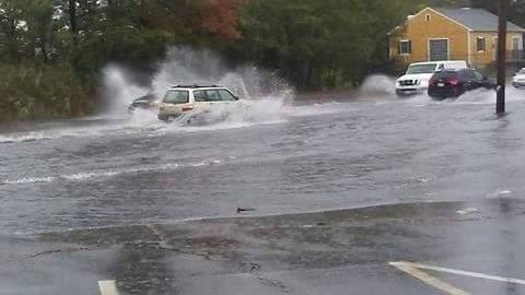
Route 6/28 through Wareham, aka The Cranberry Highway, is impassable for all but the highest-profile of vehicles.
Drenching rains are pouring down on the 'Ham, and the area in front of the old 99 is an urban river.
This is the second time this week that the Cran has been too flooded to drive through. Any good rain does it these days.
Note that this is a major evacuation route for Buzzards Bay and Wareham, especially Onset, in the event of a hurricane. You'll want to get ghost early if your evacuation plans include East Wareham,
We'll be back if an update is necessary.
Click the "East Wareham" link at the bottom of the article for the map location of the flooded road.
Not a lot of people know this, but we saw the Fake News trend coming back in 2011. OK, maybe "we" is stretching it, as the true answer is "Walter Brooks of Cape Cod TODAY saw it coming and decided to try out a Murdoch-style News of the World website applied to Cape Cod." He then handed the idea off to his star blogger, who- sadly- also wasn't me. "We," meaning "Stacey Monponsett by herself," thought up the idea of having a sea monster attack the 2011 Cape Verdean Festival. Me? My job was to produce a picture of the sea monster. My efforts get dismissed pretty quickly in the article, and rightfully so. I get the last laugh, though. The site never gained momentum, and was abandoned. I am the first of us to even think of it since, and I'll see if I can make a few bucks off of the story in this new post-truth era of media. I should add here that I have been in media before, during and since 2011, and my ability to alter a picture of something normal into a convincing sea monster has not improved one iota. So, without any further ado... Listen, children, and you'll never forget... Manny, the Beast of Onset.
SEA MONSTER DEVOURS 70 IN ONSET
The very foundation of Science was rocked today as a thirty meter sea monster emerged from Onset Bay and attacked the Cape Verdean Festival.
The monster was described by witnesses as looking "like a moron photoshopped a swan," while others said it looked like the famous sea serpent which attacked Cape Ann in 1639. It struck without warning and went straight for the Cape Verdean Festival, where thousands of revelers were enjoying an afternoon of heritage. It was described as over 30 meters long, with a generally Nessie-like appearance. It's head- at the end of a snakelike neck- was higher than the 40 foot high tower on the Inn At Onset Bay.
Ambling ashore, the creature immediately ate a family of 7 European tourists who were playing in the surf. It then attacked and sank an Onset Bay tour boat, which was hosting a fundraiser for the local Tea Party chapter. Tax reform advocates were gobbled like Pez as they swam for the perceived safety of the shore.
Not satisfied, the creature attacked the festival. Heading straight for the linguica stands, it paused only to snatch a few dozen of the slower people as the crowd ran for their lives. The people in the audience with concealed weapons began to fire upon the monster, with little effect.
The arrival of heavier armed police did little to slow the monster's rampage. Even the SWAT team was powerless against the beast. Swallowing a last resident, it jumped back into Onset Bay and swam towards New Bedford.
Experts are at a loss to explain the monster. It is unlike anything known to modern science, and would fit better in a Saint George legend. The Coast Guard and the US Navy were both eluded by the swift-swimming beast. The USS Kardashian had a sonar reading off Falmouth, but it turned out to be a rotund Connecticut tourist who was floating on a raft.
The possibility of a man-eating plesiosaur living off Cape Cod isn't expected to harm the region's tourist industry much. Onset is jammed with sightseers, and locals are selling them numerous t-shirts, bumper stickers, and trinkets modeled on the beast. Charter boats from Bourne to Brewster are booked for years in advance.
Locals have taken to calling the beast "Manny," in honor of Manny Monteiro, a linguica cart owner who tried to defend his business with a machete. He was bisected by the beast, who he swore to fry and consume. Wareham has named the high school sports teams the "Mannies" in his honor. Mark Anthony's Pizza now features a "Mannywich," which is a linguica/peppers/onion sub coated with Monster Blood (tomato sauce). Ben Affleck is rumored to be playing the valiant cartpusher in the movie.
Buzzards Bay has plenty of fish/whales/tourists to support a large colony of Mannysauruses. A Manny may very well be what attacked Provincetown in a 1719 legend, as well as the source of "globsters" like the one in Nantucket. It also explains a lot of whale beachings, and solves the questions associated with a right whale who washed up on Duxbury Beach with a 10 foot bite taken out of it. "The Beast of Onset could easily rape a blue whale if it wanted to," said one eyewitness.
A state of emergency was declared by Massachusetts governor Deval Patrick, and armed units of National Guardsmen are lining the shores of Massachusetts beaches. Machine guns, rocket launchers, and main battle tanks prowl the coastline. All of Cape Cod wonders where- and when- the Beast will strike again.
This picture was taken from where the old 99 Restaurant was on the Cranberry Highway in Wareham.
The town may have a bit of a problem here. This is the main road in East Wareham.
Granted, we had furious rainfall yesterday. However, this has been a long-running problem in the area.
I was driving in this area during Hurricane Irene, when 7 inches of rain fell. The flooding, which only covered a hundred yards of Cranberry Highway in yesterday's event. spilled into the Wal-Mart parking lot. I saw a people who were nearly washed away by it.
The road was impassable, and flooding was bad enough that a car was stranded and abandoned by the 7-11. I saw one guy stall out in the mess yesterday, and he had to shove his car out of the water.
I'm guessing at this, but Dick's Pond and Sand Pond may also be prone to sending their overflow into the Cranberry Highway, as the road flooding I have seen along this road over the years went down near each them.
This could be a major problem if a hurricane strikes us full-bore. This road, which is pretty far back from the sea and was flooded yesterday by rainwater, is the only way to evacuate Onset.
I have no idea how to fix stuff like this, but someone must. It seems to be a pretty major problem.
...BARNSTABLE COUNTY...
BUZZARDS BAY 2.7 930 AM 3/21 SPOTTER
EAST SANDWICH 1.8 500 AM 3/21 NWS EMPLOYEE
EAST FALMOUTH 1.5 703 AM 3/21 NONE
HYANNIS 1.5 730 AM 3/21 MEDIA
WOODS HOLE 1.0 600 AM 3/21 CO OP OBSERVER
CHATHAM 1.0 800 AM 3/21 CO OP OBSERVER
CENTERVILLE 1.0 600 AM 3/21 NONE
SOUTH SAGAMORE 1.0 619 AM 3/21 HAM RADIO
FALMOUTH 0.5 725 AM 3/21 HAM RADIO
Aimed At Sandwich
...BRISTOL COUNTY...
REHOBOTH 3.9 905 AM 3/21 NWS EMPLOYEE
NORTON 3.6 700 AM 3/21 CO OP OBSERVER
DIGHTON 3.5 928 AM 3/21 NWS EMPLOYEE
TAUNTON 3.5 700 AM 3/21 NWS OFFICE
SWANSEA 3.2 950 AM 3/21 SPOTTER
FALL RIVER 3.0 915 AM 3/21 NONE
MANSFIELD 2.5 738 AM 3/21 TRAINED SPOTTER
NEW BEDFORD 2.0 511 AM 3/21 AMATEUR RADIO
ACUSHNET 1.8 620 AM 3/21 NONE
NORTH ATLEBORO 1.7 840 AM 3/21 NONE
FAIRHAVEN 1.5 625 AM 3/21 NONE
WEST ACUSHNET 1.5 642 AM 3/21 HAM RADIO
Plymouth, The White Cliffs... lol
...DUKES COUNTY...
WEST TISBURY 1.3 629 AM 3/21 NONE
EDGARTOWN 1.0 900 AM 3/21 CO OP OBSERVER
Bournedale
...NORFOLK COUNTY...
MILLIS 4.5 900 AM 3/21 SPOTTER
DOVER 4.0 815 AM 3/21 NONE
BRAINTREE 4.0 522 AM 3/21 AMATEUR RADIO
FOXBORO 3.2 815 AM 3/21 NWS EMPLOYEE
MILTON 3.2 830 AM 3/21 BLUE HILL OBSERVATORY
SHARON 3.0 839 AM 3/21 HAM RADIO
FRANKLIN 3.0 700 AM 3/21 CO OP OBSERVER
NORWOOD 2.7 736 AM 3/21 NWS EMPLOYEE
WALPOLE 2.6 737 AM 3/21 HAM RADIO
NORTH WEYMOUTH 2.5 638 AM 3/21 TRAINED SPOTTER
FOXBOROUGH 2.5 716 AM 3/21 HAM RADIO
RANDOLPH 2.5 545 AM 3/21 TRAINED SPOTTER
BROOKLINE 2.4 845 AM 3/21 HAM RADIO
WRENTHAM 2.2 811 AM 3/21 NONE
Sagamore Heights
...PLYMOUTH COUNTY...
WHITMAN 5.3 957 AM 3/21 TRAINED SPOTTER
HANOVER 5.0 534 AM 3/21 GENERAL PUBLIC
N. SCITUATE 4.8 657 AM 3/21 MEDIA
BRIDGEWATER 4.0 700 AM 3/21 CO OP OBSERVER
ROCKLAND 4.0 720 AM 3/21 SPOTTER
WAREHAM 4.0 933 AM 3/21 NONE
HINGHAM 3.6 928 AM 3/21 NONE
MIDDLEBORO 3.0 700 AM 3/21 CO OP OBSERVER
KINGSTON 2.5 731 AM 3/21 TRAINED SPOTTER
CATERVILLE 2.5 908 AM 3/21 NONE
PLYMOUTH 2.0 524 AM 3/21 AMATEUR RADIO
DUXBURY 2.0 721 AM 3/21 HAM RADIO
WEST WAREHAM 2.0 745 AM 3/21 TRAINED SPOTTER
ROCHESTER 0.7 800 AM 3/21 CO OP OBSERVER
Cape Cod Canal
I'm hardcore enough that I got in 18 holes today at White Cliffs. I also golfed.
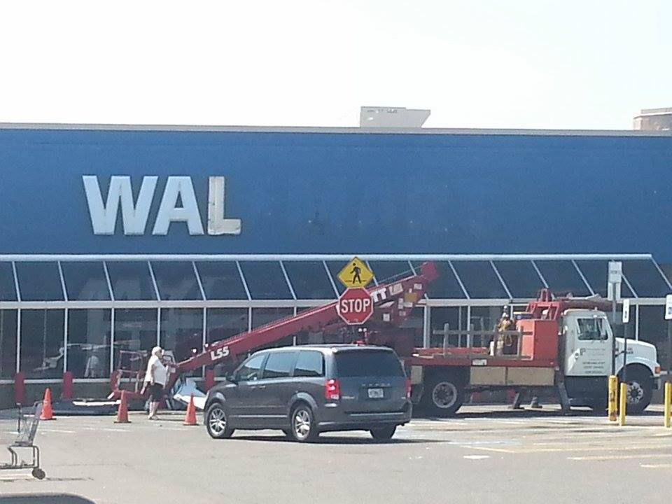
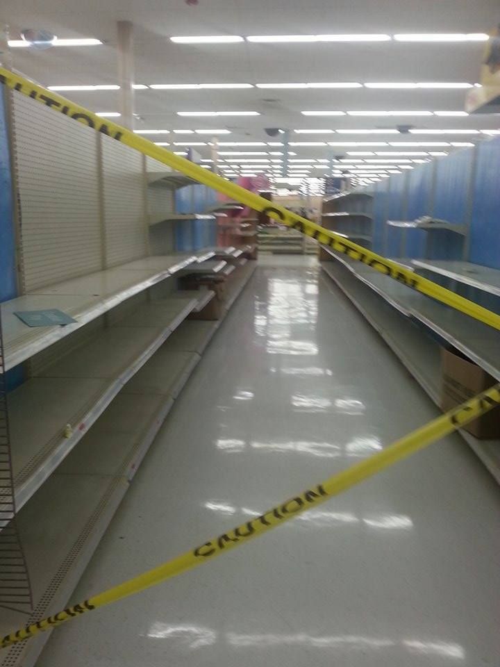
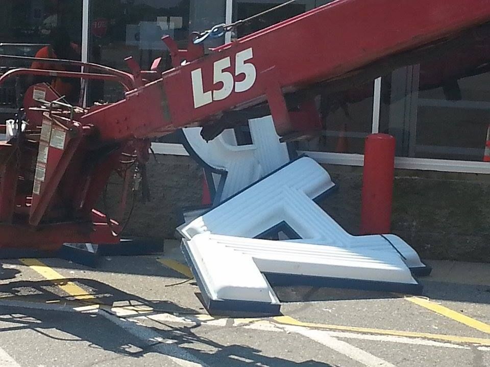
Things looked bad for the east side of the 'Ham when Wal-Mart left the Cranberry Plaza. Coming on the heels of Staples hauling up stakes a few years ago, it looked like a deathblow for a whole section of town. Wally was the engine that drove the local economy.
More than one local who I chatted with mentioned how leisurely it was to drive on the Cranberry Highway since Wally moved along. It used to be awful, and you were taking your life in your hands any time you tried to cross it... especially on foot.
It's tough to replace Wally. You don't do it with just one store it seems, as two stores have rushed in to fill the void created by the Drang nach Westen of Walter Mart. Cardi's (of Wareham) is coming soon, and the Ocean State Job Lot just opened.
Coming soon... Cardi's!
So, with Wally just down the road a bit, and two new stores setting up shop in Wally former nest, what's not to like?
I do worry some about the Buzzards Bay version of the Ocean State Job Lot, as I can't imagine that the demand for OSJL's particular inventory can support two stores within a mile or two of each other... but I also do this for a living, so what the Hell do I know?
Locals recall that Buzzards Bay once had a Burger King, but that it moved down into Wareham. Dunkin' filled the void, and would be the leading candidate to shift into the OSJL's Buzzards Bay location if they decided to just host one store in the area. I can see Dunkin' wanting very badly to be posted up on the Belmont Circle rotary.
But that's putting the cart in front of the horse. For now, we picked up some new jobs, we filled an ugly gap in a crucial local marketplace, and we'll see how things shake out from there.
This sort of kills my plans to write about the abandoned Wal-Mart being used to house and supply UN troops (Chinese and North Korean), who are being based here for when the one-world government comes to confiscate our guns.
I was going to get my friend Tristan to pose outside the abandoned Wal-Mart in a homemade UN jacket as a sneaky-looking North Korean occupier. He's of Japanese descent, but he'd pass in a pinch.
Now, I'll never get on Infowars.com. Maybe I can get a Jew or a Freemason poisoning a well.
I want the ship clock up there for a blank spot on my office wall....
... as well as this thing to pick cookie sheets up with that looks like Cookie Monster somehow got a baby up in Kermit T. Frog.
In this town, on this day, the Wal Mart has giveth, and taketh away....
A seismic shift in Warehm's economic existence is going down today, as the Wal-Mart on the Cranberry Highway closes her doors for good. They are moving their operations into West Wareham.
Their lease in East Wareham wouldn't let them sell groceries, and the new store will be right where 28/25/6/495/195 converge. People like to beat up Wally, myself included, but you can understand their motivation here.
This is a massive change to the face of the town. East Wareham loses her Boss business, and the effects will reach far beyond the 4 walls of the store.
West Wareham, which as a backwater until recently, got Wareham Crossng in 2007. That, and this Wal-Mart, killed off 350 acres of forest. It turned a rural area into a traffic destination. There are those who say that one of the Walton heirs personally came to Wareham and stomped all of the Eastern Box Turtles on the property to death.
The Weweantic River, which feeds off the streams near Wally, is said to be less than pleased with the Walton's arrival. She may be a new channel to dump more nitrogen into Buzzards Bay, and doom what is left of our shellfishing.
The Crossing radically changed West Wareham, and the Wally will change it more.
Wally will also change East Wareham, his former home. Wally is leaving a plaza that has already lost Staples, TJ Maxx, and Friendly's... each of whom (I'm not 100% sure about the Friendly's, and Jessica is over there doing the pics as I write this) moved to the more-happening West Wareham area.
Not many businesses of any power are now on the Cranberry Highway in East Wareham. The biggest business there which isn't serving food or pouring gasoline is either Benny's or Sullivan Tire. Ooops, I almost forgot Home Depot... although I wonder how long they plan to stay there?
Can you really anchor a business district around what is left in East Wareham these days? I do wonder if the region will be able to support the Fast Food Fab Five (McDonald's, Burger King, KFC/Taco Bell, Wendy's and Subway) without both the WalMart customers and her employees. I'll be less than pleased if I have to go to Exit 6 in Plymouth to get Papa Gino's pizza, I'll tell you that much.
Fortunately, because there's a Dunkin' Donuts every 200 yards, the coffee people will be OK.
When the foodies leave, that's when you can start digging the grave. That chops the low-level jobs from the region by the dozens, Those businesses tend to anchor themselves around the big business in the area, and they won't survive picking off the few people who need to go to Benny's.
Stop n Shop now anchors the plaza that Wally used to own, with help from Radio Shack, Delken's Laundry, the Dollar Store, ProCuts and a nail joint. Throw in a few banks and some squalid motels, and that's the backbone of the business district.
This section of town is doomed... and it has been in the spiral since 1987. That was when Route 25 was expanded to the Bourne Bridge, which took all of the tourist money away. That killed the dog, although the tail was wagging until Wally hauled up stakes for the other side of the tracks. Expect no help from the government. Our fair Gateway has been the neglected stepchild of Cape Cod for decades.
The bad part is that, on the surface, this looks like a positive. Wareham just shifted their Wally a few miles down the road, so only the poorest motel-living people will lose access to Wally's Asian-crafted goodies. Rather than killing jobs, the move up to Super status created 85 paying gigs for people in a pretty poor town. Traffic congestion is East Wareham should be lightened considerably.
The worst part is when you think about it deeper than that. There is no silver lining... that's just how the edge of the blade looks when your section of town is on the chopping block.
I have a few ideas as to what to do with the old Wally building, but that will be for a future article. I still need to find an Asian kid to pose for my Jade/Helm occupying UN/Chinese soldier photos.
In the meantime, I look at East Wareham and just shudder. There's a bad moon on the rise.
I doubt that Jessica was aiming for irony with her camera, but she found some.
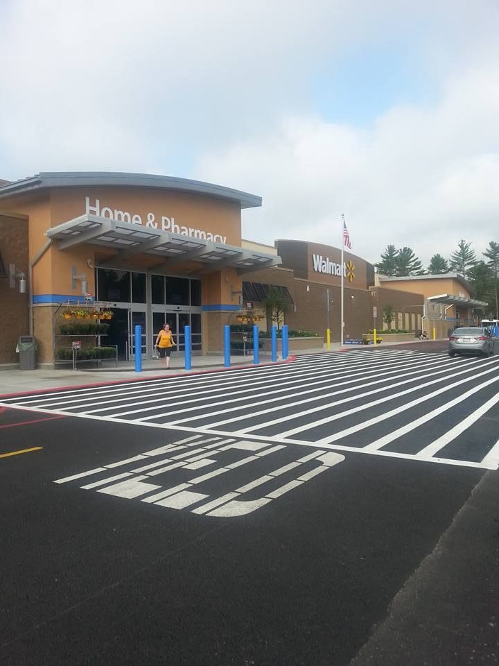
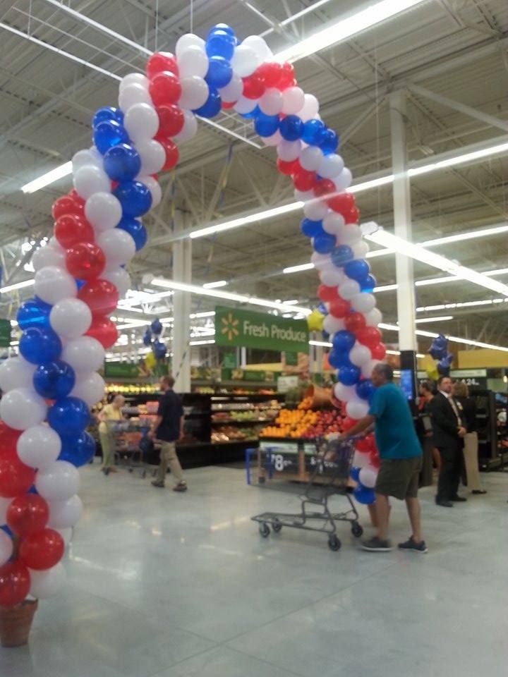
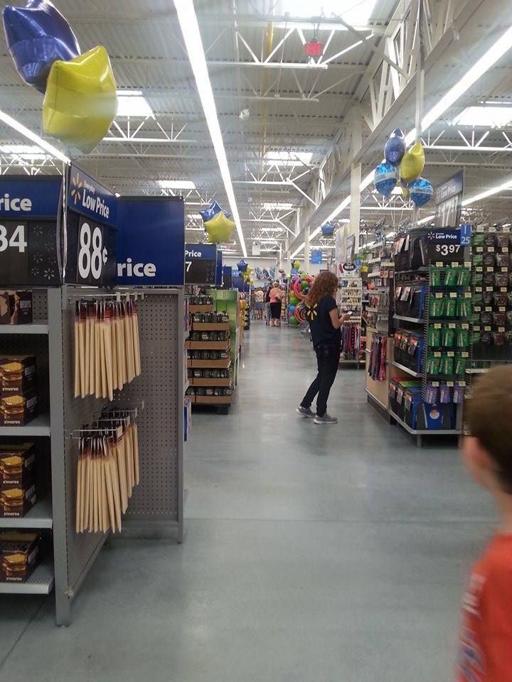
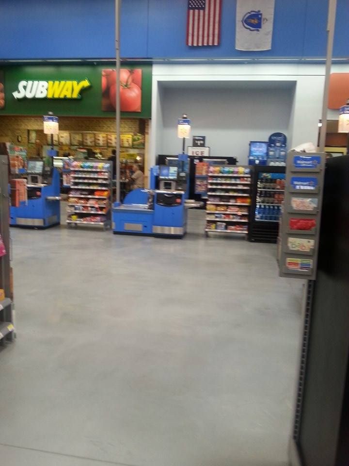
The West Wareham Wal Mart Supercenter opened today. It replaced the Wal-Mart in East Wareham.
The big difference is that this is a Super Wal-Mart, which means that they have a supermarket.
As you can see, no expenses were spared to welcome the shoppers to the new Wally.
There are some pros and cons. It's not a 24 hour Wally, which is bad news for journalists who might be nocturnal. They have the same Subway franchise as the other Wally did, with the same people running it. There isn't a bank in it.
They do have a nice grocery section, and it's a brand new building. The grocery section is bigger than the old Wareham location, but not as big as the one n Plymouth. You can drop right off 195 or 25 onto it.
There aren't any bells and whistles, it's a Wal-Mart. You'd like to think that new ones would be spectacular, but they pretty much have about 5-20 blueprints they break out depending on how big the town is, or how close to the highway the store is.
Nothing against my girl Red, however... she's puttin' in work.
Nothing says "Patriot" like a 100% Made In China tailgate zone. Winner of the 2015 "Most Ominous Use Of Scarecrows" award at Cannes.
Wally was giving out some free stuff, and they had vendors all over the place. Do note the Wareham school colors on that cupcake, homie!
If you hug it, it gives you a free drink. When I dry-humped it, it had the nerve to give me a Coke Zero. It'll be amazed when I don't call, too...
"Rotting meat on stale bread, prepared by savages"... Jim Norton, on Subway
All this and more awaits you at the West Wareham Super Walmart Supercenter!
On June 13-14th, 1814, war came to the South Coast...
Coastal towns in colonial/post-colonial America tended to be centers of piracy, which we called privateering back then. As near as I can tell, the difference is that a privateer has a letter from the Queen or the President, while the pirate is in business for himself.
It was a pretty good deal. You could get a letter of marque from the government and go hunting for British shipping. 300 British ships were seized in the Revolution, and I'll get the 1812 number later (251 registered privateers, they got 1500 British ships). Them's righteous bucks, real J-Lo style booty.
New England represented hard back in the pirate days, for several reasons. New England is home to numerous ports, harbors, coves, lonely beaches, sneaky little islands, hidden inlets and course-dictating currents. All of these aid the piracy effort. The coastlines of New England in general and Cape Cod in particular are nothing but all of the above. Wareham is even worse.
We're also a nautical people- you tend to not notice it while you're living here, but if you go inland a bit, you realize how unusual it is in America to have been on a boat that has, say, pulled up a lobster trap.
We still depend on the sea now, but we REALLY depended upon it back then. New Englanders sailed instinctively, rowed like a motherlover (when fleeing New York, George Washington made sure that Massachusetts guys were doing the rowing), and more than one of our Captains sailed rings around more than one of their Admirals. I should add that, for some reason I have no theory on, our coastal people sail better than, say, Carolina's coastal people.
Finally, we're centrally located. If New York City is a mall and London is a very nice trophy home, Cape Cod is the nasty neighborhood you have to carry your goods home through. There are a hundred places to attack from around here, and a million places to escape to afterwards. Cape Codders are not afraid of a little dirty money now and then, even if we have to cut the government in on it.
The Brits were doing it to us, too, so it's not as Somali as it sounds. Even if it is, Cape Cod fattened itself quite nicely on British shipping during the times of trouble. It was all good until John Bull came to town to get some payback.
The British became aware of a ship with a letter of marquee being present at Wareham. Wareham had dodged trouble in the Revolution, but she had a fine privateering history. The sloop Hancock came from Wareham, Capt. John Kendrick of Wareham was the boss on the Fanny and the Count d'Estaigne and Capt. David Nye was the Head Sailor In Charge aboard the Sea Flower.
The squadron centered around HMS Superb off of New London dispatched HMS Nimrod with several smaller ships to burn the pirate ships... and perhaps the town around them. Nimrod was a frequent foe of American privateers operating off Cape Cod, and had bombarded Falmouth the December before.
On June 13th, Nimrod came within sight of Fort Phoenix in Fairhaven. Residents of New Bedford and Fairhaven began to flee to the countryside as the militia began to gather. This may have been a feint meant to send militia to the wrong place. A sizable militia gathered and Fort Phoenix let off some shots (more to summon militia than to sink Nimrod), but the British moved past it. Militia headed to Mattapoisett as well, but the British kept heading up Buzzards Bay to Wareham.
The Nimrod then dispatched barges carrying 225 soldiers up the Wareham River, and they landed where the Narrows Bridge (pictured above) is now, near Tobey Hospital. Risking gunfire from both sides of the river, they came ashore and invaded Wareham.
They sent sentries to inhabit the high ground, and then fired a Cosgreve rocket (a British incendiary weapon, known for it's songworthy Red Glare) into a cotton factory that had been built by a consortium of 60 Boston businesses. The locals managed to put the fire out, but much damage was done.
The Brits took a Captain Bumpus (who may have been the Bumpas kidnapped from Westport, most likely set up by the spy who relayed the news of a privateer at Wareham) to his home, where they destroyed/confiscated military supplies.
A party of Wareham man arrived to see how we could get out of this, and the Brits said they were here to find men and ships related to privateering, and that they would not fire on inhabitants or destroy private property. They were very interested in ships belonging to Falmouth, which they had attacked 6 months before.
We lost a lot of good boats that day. The Fair Trader, 44 tons and able to hold 18 guns, was burned down to the hull. The brig Independent suffered the same fate at 300 tons. She was in the stocks, ready to launch. We also lost brand new schooners Fancy, Elizabeth, and Nancy. All told, a total of four schooners, five sloops, a ship, a brig, and a brig-under-assembly at William Fearing's shipyard were put to flame.
Wareham scrambled up what militia they could get (a dozen or so men under Issac Fearing), and marched forward to fight 225 British marines. The Brits were leaving by then, after having done $1 million (an incalcuable amount today) in damages, half of it being suffered by the cotton factory. The Brits fired more rockets into the town, which they threatened to burn upon their return.
On June 20th, two unidentified young men were sent to the Circuit Court in Boston under charges of Treason for aiding the British in their attack on Wareham.
The Nimrod then, at some disputed point, ran aground at Quick's Hole (a strait between Presque and Nashawena in the Elizabeth Islands, both islands are currently owned by the Forbes family) and had to ditch their cannon to get afloat. Nimrod survived until 1827, when she was heavily damaged off- ironically- Plymouth, England.
Wareham was down but not out, and the nation they live in eventually became so powerful as to eclipse England. Issac Fearing has a Wareham street named for him, and Brits are considerably more polite when they come here now.
Ironically, Wareham's own Geena Davis is said to have personally killed the pirate-film genre with her film Cutthroat Island. Johnny Depp eventually revived the genre, but I don't think that Geena has worked since.
This film was notoriously bad. Matthew Modine was the male lead, and was reportedly the 10th man offered the role. Geena was married to the director, always a good thing. One character was sacked after trying to expose himself to Davis. The production company that made the film ceased to exist afterwards. "I could watch everyone in this movie be skinned," Gene Siskel once didn't say.
Despite the bombing it underwent, Cutthroat Island eventually made well over a million dollars in the UK once it went to video. One million dollars was about how much damage the British dd in 1813.
Say what you will about Geena Davis, but she took up the sword and got Wareham some reparations. That's my kind of girl. I ought to invite her to the Buzzards Bay Compound...
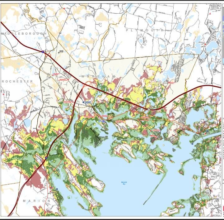
Wareham has a long and lengthy history with ol' Mister Hurricane. Just looking at that map above without knowing what it means, you can see that trouble would be afoot for ?ham if the barometer drops too much.
Wareham has taken beatings from Hurricane Bob, the Long Island Express, and a dozen other storms, and that's just in White Guy history. If you work in the native population, the numbers become countless after an eon or ten.
The 'Ham ( I really want to write a cop show for TV, base it in Onset, and call it "The 'Ham") suffers from the same problem which places like Bangladesh have.... it exists at the tip of a funnel. The funnel is formed by Buzzards Bay. That's the body-of-water Buzzards Bay, not the village part of Bourne... those people share the same Bangladeshian funnel problem that ?ham has.
Hurricanes, with both the wind and storm surge, push water ahead of them. That's actually what the storm surge is. It's not a problem in the middle of the Atlantic, but that water has to come ashore somewhere, and that somewhere is often at what they call the head of the bay. That's Wareham.
In fact, the "where" sound in Wareham may actually refer to "where the water goes." Water cares very little about washing over roads, cars, houses, people.... once it gets off the beach, we have a natural disaster on our hands.
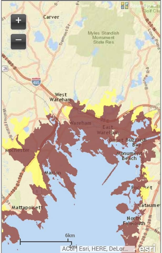
You have two maps here, folks... the upper one shows Inundation, and the lower one shows Evacuation Zones. The maps are from June of 2014, and- to my knowledge- are the plan du jour.
"Inundation" is a nice, painless term that means "covered in water," but you can change it to "Deathflood" or "Sea Plague" if it gets the troops moving quicker.
They (these maps are produced by the National Hurricane Center) assume that Wareham gets a direct hit at high tide, and follow the (groan) SLOSH model of seawater redistribution that MEMA and others use. They are assuming worst case everything insofar as wind direction, phase of moon (check that, they use Mean High Tide), forward speed of the storm and everything else goes.
Those pretty colors are actually differing levels of devastation. I had a map/legend thingy in the Photobucket somewhere, but I'll just say that light green is a Category 1 storm, dark green is a Category 2, yellow is a Category 3, and red is a Category 4.
For a basis of comparison, what Wareham got from Hurricane Gloria may have been a weak Category 1 storm (she came ashore in Connecticut), the Blizzard of '78 was about a strong Category 1/weak Category 2, Hurricane Bob was moderate Category 2 ("moderate" and "Category 2 hurricane" are kind of odd words to string together), old timers may have witnessed Hurricane Carol at Category 3, and The Great New England Hurricane of 1938 was a strong Category 3 made worse (Blue Hills got a 186 mph wind gust) by her forward speed.
The colors show which sort of storm will inundate which areas. Light green means you are hurting in even a weak hurricane. Any shift in colors after light green means that the storm will have to kick it up a notch to reach that area. Red areas are places that will only suffer- but suffer they will- in a Category 4 storm, the likes of which hasn't been seen by White Men in these parts. Hurricane Bob was our 11th deadliest storm ever in Massachusetts, in case you were wondering where your memories rank all-time.
The lower map, Evacuation Zones, is a bit easier to follow. They have three zones of evacuation. The third zone is reserved for storms we don't get, because I never saw the third color, and I looked at 30 town maps. The other colors break down as red = They Have To Leave and yellow = You Have To Leave, Too.
If you stare at the top map a bit an then stare at the bottom map, you'll get the basic idea of the Hows and Whys.
This is a frightening amount of Inundation territory. Wareham is home to 21,000 people. Almost all of them would be underwater in this scenario. To make it worse, these maps only show part of the problem. There will be high winds, downed wires, falling tree limbs, river flooding, sewer overflow, road washouts... you know, the whole nine.
I can leave the worrying to you. It's my job to provide the maps and some insight. My work is done here. Godspeed.
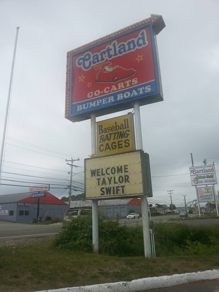
Driving down the Cranberry Highway today, while viewing the normal clutter of signs and billboards, one name caught my eye.
TAYLOR SWIFT
Cartland, an East Wareham amusement park (I'm stretching the term here, it's mini-golf and batting cages) has a sign up today that says "WELCOME TAYLOR SWIFT."
Everyone loves Swiftie, the impossibly cute songbird of kid-pop fame. She is one of the most famous people on the planet. Forbes has her net worth listed in the zillions. What the heck would she be doing in friggin' East Wareham?
I called Cartland. I expected some lame answer, something along the lines of "We're playing Taylor Swift music all day Saturday." What I got was my favorite answer, the one that lets me exercise my skills a bit.
"No comment."
Hmmmm... that leaves a lot to the imagination, no? Here's what I can come up with.
- Taylor is filming a video, and- for artistic reasons- she needs a shabby mini-golf course in a small town.
- Taylor is filming a video at, naturally, Swifts Beach in Wareham. Perhaps she intends to buy the whole of Swifts Beach, it's what I'd do if I were her.
- Taylor took a vow of poverty, and is now shacked up at the Silver Lake Motel with some Cape Verdean dude named Manny.
- Taylor has a place in Rhodey, and made a Rhode Trip into ?ham.
- Taylor, who bought a house in Hyannis Port while she was dating Konnor Kennedy (I may have spelled that wrong), is now in town to sign papers to rid herself of that house.
- Taylor is dating that Kennedy whelp again, and is basing herself in an area where all the roads lead. The Hell's Angels used Bourne for that very reason for several years, and the "all roads lead here" explanation is essentially why Gettysburg was fought where it was fought.
- Taylor, who has a show in Montreal tonight, wanted to play mini-golf in Wareham for reasons that only Taylor Swift knows.
- This paper can neither confirm nor deny the rampant rumors that Taylor Swift was seen having dinner with Duxbury philanthropist Stephen "Hoss" Bowden. Bowden owns property in nearby Buzzards Bay.
- John Henry, who has enough money to date her, has a place in Onset. No, not the steel-drivin' man John Henry, the Red Sox owner John Henry. While we're cherry-picking rich-and-or-cool celebrities, Bob Kraft has a place in Mashpee, Joe Perry lives in Duxbury, Bobby Orr lives in Sandwich, Meghan Trainor lives on Nantucket, Bill Belichick summers on Nantucket, Jay Miller lives in Cataumet, and Ben Affleck is in nearby Boston (and is freshly single). Marky Mark? Matt Damon? Rocky Marciano III? Quint? Crikey, it could be anyone!
- Wareham has been very friendly with the movie industry lately, with Adam Sandler and Steve Carell having filmed movies in a nearby water park.
- Taylor is a Dawson's Creek fan, and is trying to find locations to represent the show's fictional Massachusetts seashore town of "Capeside" for a Dawson's Creek movie. I actually don't know if she acts or not, I'm sort of culturally illiterate.
- Taylor is dating the next A-ROD, who is currently an unknown playing for the Bourne Braves or the Wareham Gatemen. Pop stars have a nose for that kind of thing.
- It's not THAT particular Taylor Swift who is coming to Cartland, as the park instead found someone with that name and is letting them mini-golf for free as a publicity stunt. Cartland is, after all, the home of the Beach Bucket Sundae.
- Swift has a show in Foxboro on July 25th, and is in town doing prep work. She wanted to mini-golf, and her staff was ordered to find mini-golf. Not being locals, they chose a Wareham course instead of something closer to Foxboro.
- South Coast... it's now, it's happening!
Either way.... if you want to see Taylor Swift in person and maybe carry her off in a sack like Borat... you could do a lot worse than to hang around Cartland and see if a limosuine pulls up. Don't say that we didn't warn you.