It's more of a nor'easter town than a hurricane town, but A does not necessarily preclude B in this case. Marshfield is cap-ee-tull-T Trouble in any coastal storm situation, just because of the lay of the land. That's not going to improve if the winds get over 100 mph.
For starters, they didn't name the town Marshfield because some guy named Marsh founded it. Marshes, moors, swamps, bogs and estuaries all define the town''s geography. You can't be the green-bleeding heart of the Irish Riviera without some bogs to trot on, no?
Marshfield's eponymous marshes and her river mouths (you expect the North River to be trouble, but the itty-bitty Green Harbor River?) ensure that a lot of water will be flowing through and collecting in Marshfield during any rain event. That's before we factor in the waves breaking over houses.
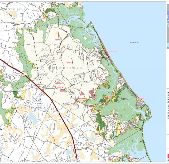
The map above is what they call a Hurricane Inundation Map. It's what floods in town, and note that these estimates are only for salt water flooding. They assume a direct hit (almost impossible in Marshfield's case) from a hurricane at mean high tide.
The map (provided by the NHC and FEMA) is a bit tough to read, as tidal flooding far inland made for a need to zoom the map out. You can still see enough to know, and local knowledge is probably as good as any map.
Of course, your local knowledge isn't top-notch until you can trace your residency back to a signature storm like Hurricane Carol, the Blizzard of '78 or the Halloween Gale. You can always talk up the longest-standing resident of the neighborhood for local flooding history, and any solid plan for a coastal resident should include such considerations.
The light green areas on the map are areas that would be underwater in a Category 1 hurricane. Darker green is Category 2, and yellow is Category 3. Keep in mind, five Category 3 hurricanes have hit New England since the white man arrived. FEMA also provides areas (the reddish shade) that would get hit in a Category 4 storm, which we have not had in modern history. That scenario almost-but-not-quite puts the Dairy Queen under seawater.
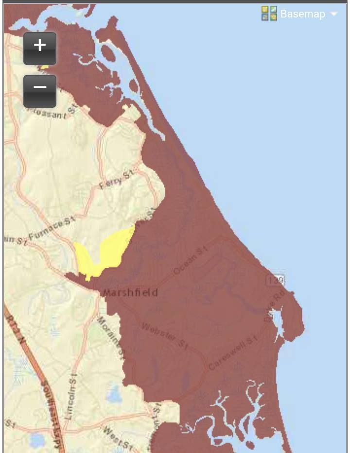
The authorities are also nice enough to give us Evacuation Maps. These are a bit more broad-stroked and are much easier to read.
Basically, red means "those people have to go," while yellow means "and you have to go, too."
Marshfield is an odd geographical thing, very close to sea level, and even the high ground drains downhill into the marshes. Areas of Marshfield that shake off a nor'easter with just some frozen spray on the houses may be in for a rude awakening if a Bob-style hurricane unloads on her. Once those marshes top off, the water has nowhere to go except into the neighborhoods.
Much of the area's coast (hello, Rexhame and Humarock) is wedged between the sea and the South River, which only aids the inundation process... which, in turn, spurs along the need to evacuate.
Most of Marshfield's coast- and any areas along rivers or marshes- would have to be evacuated in even a minimal hurricane forecast to hit at high tide. Greater storms would force people near the Fairgrounds to evacuate.
A solid run from the Duxbury border, through Green Harbor, Brant Rock, Ocean Bluff, Fieldston, and Rexhame to the tip of Humarock would be Gotta Goville. I'm guessing, but at the height of summer, that might be 10,000 people.
From what I can see of the maps, people might want to head for the (Marshfield) Hills.
It's like we say on Duxbury Beach... "The other 364 days of the year are beautiful." If you want to play with the maps or get the links to other towns, maybe see how bad the other suckers near you are gonna get it.... FEMA Inundation Maps For Massachusetts. You can also window-shop other town's disaster porn with the FEMA Evacuation Zone Maps For Massachusetts.
Marsh Vegas, as you can see, gets wrecked on the regular.
(Editor's Note: This article is from about 5 years ago, we diggin' in the crates...)
The Boston Globe and Google Maps are doing a cool service with this map of Massachusetts seawall conditions. Clicking on the individual areas lists the location and repair costs. Every seawall pictured on that map would cost $160 million to repair.
You can see the real thing here at the Globe, but I took the liberty of pasting a few shots of local areas for educational purposes only.
The map shows who has seawalls. The color code is basicallyGreen meaning high quality,Orange meaning poor and Red being critical/non-existent.
The Outer Cape has her own seawall, that being a mountain of dunes. They were what Massachusetts defended herself with before the people era. Anyhow, that's why there are no seawalls of any note on the outer Cape.
They didn't have any info on Nantucket and Martha's Vineyard. I'm sure there are some localized seawalls, at least.
Note that the lower Cape seawall system is designed to stop hurricanes, while the South Shore's is designed to stop nor'easters. That's not 100% exclusive, but it's a good rule of thumb.
Falmouth is heavily sea-walled, and another strip runs off and on from Yarmouth to Chatham.
Seawall repairs are costly. Provincetown alone needs $5 million in seawall repairs. We're coastal people, and we have coastal problems. Things will only get worse if that global warming/sea level stuff is true.
Barnstable is very much unprotected by seawall, so they at least may get to dodge some of this Cost Bullet. They may be penny-wise and pound-foolish, but time will tell.
I'm no expert on the Cape's specific coastal areas, so I'll leave it to you to draw your own conclusions. If you have your own observations, leave them in the comments section.
I did some zooming, and isolated the two wall-iest areas of Cape Cod.... Here's one of them, the Falmouth/Bourne/Sandwich/Onset area. Everything on the map below would cost about $50 million to repair.
Falmouth is obviously prone to terrible tides, and the extensive seawall construction speaks volumes. The areas of Bourne and Onset were devastated during Hurricane Bob, right about where that hurtin-for-certain seawall is.
Much of that seawall is in need of repair. Those repairs will be costly. $50 million dollars = costly. Those repairs are small change against what losing miles of beachfront property would mean in taxes and tourism.
Estimates include seawalls, jetties and anything else armoring the coastline.
The run of seawall that goes from Bourne Pond to Jeweler's Road in Falmouth adds up in several increments to equal $3 million in necessary repairs if you throw in the nearby Eel Pond seawall.
The seawall on Ocean Avenue to the Great Pond area of Falmouth needs $3 million in repairs.
Falmouth Heights needs $4 million in seawall repairs.
Lewis Point in Buzzards Bay needs $500,000 in repairs.
Onset is looking at $1.5-2 million in repairs
Here's the Yarmouth-Chatham run... price tag: $36 million or so.
Red River Beach in Harwich to Cockle Cove in Chatham needs $1.5 million in repairs.
Wychmere Harbor needs almost $2 million in seawall repairs, as does West Dennis Beach.
A series of seawall repairs from Parkers River to Beachwood Avenue in Yarmouth will surge well past $2 million.
Town Fish Pier In Chatham needs $500,000.
I'm not sure if the Wampanoags built seawalls. Native Americans tended/tend to be more reasonable than Europeans, and most likely just didn't settle dangerously close to the beaches.
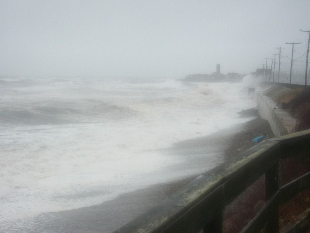
The picture below is my hometown, Duxbury Beach. I'll focus on it because A) I'm very familiar with it, and B) I have some pictures of it. It runs from the Gurnet Road area of Duxbury to Green Harbor.
The seawall shown via the stripes of different colors protects about 1-2000 people, depending on the time of the year. The Southern half is sparsely populated, making up maybe 3-500 of the total figure even in the summer. The seawall repairs will cost well over $6 million, mostly to the north (and some of which is off the map), in Marsh Vegas.
The red area on the map is a football field-sized gap between the Duxbury seawall and the Marshfield seawall. The Globe reported that there was wall there at some point that has disappeared, but no wall has been there since the 1960s. I'll ask around, but no one I know can remember there being seawall there.
The seawalls were put up in the 1950s, during a hurricane run that gave us Edna and Carol. The seawalls allowed coastal development in an area that was devastated during the 1938 Hurricane and the 1954 sisters.
The seawalls suffer from cracks, crumbling, collapse, erosion and other ailments. The seawall shown putting in work at bottom of the article is from this area.
The green area is where I'm from, and the seawall is just a big slab of concrete. It does the job we ask of it. The neighboring orange area was a portion of the wall (near the old Gurnet Inn) that had started to fall forward. The US Army Corps of Engineers is in charge of repairing the wall, and they dumped tons of boulders against it to arrest the Tower Of Pisa act.
The orange wall in more northern Green Harbor is much "taller" (more of it is exposed, where down-beach Duxbury gets a lot of sand washed up against it) than her sister to the south. Almost the whole length of it requires boulders be shoved against it to keep it from tipping forward. The houses are built right up to the seawall in many cases there.
The extreme top/north of the picture features two giant jetties, made out of piles of boulders, that protect Green Harbor.
Regarding the cost of seawalls, the old divorce joke works pretty well.
On June 13-14th, 1814, war came to the South Coast...
Coastal towns in colonial/post-colonial America tended to be centers of piracy, which we called privateering back then. As near as I can tell, the difference is that a privateer has a letter from the Queen or the President, while the pirate is in business for himself.
It was a pretty good deal. You could get a letter of marque from the government and go hunting for British shipping. 300 British ships were seized in the Revolution, and I'll get the 1812 number later (251 registered privateers, they got 1500 British ships). Them's righteous bucks, real J-Lo style booty.
New England represented hard back in the pirate days, for several reasons. New England is home to numerous ports, harbors, coves, lonely beaches, sneaky little islands, hidden inlets and course-dictating currents. All of these aid the piracy effort. The coastlines of New England in general and Cape Cod in particular are nothing but all of the above. Wareham is even worse.
We're also a nautical people- you tend to not notice it while you're living here, but if you go inland a bit, you realize how unusual it is in America to have been on a boat that has, say, pulled up a lobster trap.
We still depend on the sea now, but we REALLY depended upon it back then. New Englanders sailed instinctively, rowed like a motherlover (when fleeing New York, George Washington made sure that Massachusetts guys were doing the rowing), and more than one of our Captains sailed rings around more than one of their Admirals. I should add that, for some reason I have no theory on, our coastal people sail better than, say, Carolina's coastal people.
Finally, we're centrally located. If New York City is a mall and London is a very nice trophy home, Cape Cod is the nasty neighborhood you have to carry your goods home through. There are a hundred places to attack from around here, and a million places to escape to afterwards. Cape Codders are not afraid of a little dirty money now and then, even if we have to cut the government in on it.
The Brits were doing it to us, too, so it's not as Somali as it sounds. Even if it is, Cape Cod fattened itself quite nicely on British shipping during the times of trouble. It was all good until John Bull came to town to get some payback.
The British became aware of a ship with a letter of marquee being present at Wareham. Wareham had dodged trouble in the Revolution, but she had a fine privateering history. The sloop Hancock came from Wareham, Capt. John Kendrick of Wareham was the boss on the Fanny and the Count d'Estaigne and Capt. David Nye was the Head Sailor In Charge aboard the Sea Flower.
The squadron centered around HMS Superb off of New London dispatched HMS Nimrod with several smaller ships to burn the pirate ships... and perhaps the town around them. Nimrod was a frequent foe of American privateers operating off Cape Cod, and had bombarded Falmouth the December before.
On June 13th, Nimrod came within sight of Fort Phoenix in Fairhaven. Residents of New Bedford and Fairhaven began to flee to the countryside as the militia began to gather. This may have been a feint meant to send militia to the wrong place. A sizable militia gathered and Fort Phoenix let off some shots (more to summon militia than to sink Nimrod), but the British moved past it. Militia headed to Mattapoisett as well, but the British kept heading up Buzzards Bay to Wareham.
The Nimrod then dispatched barges carrying 225 soldiers up the Wareham River, and they landed where the Narrows Bridge (pictured above) is now, near Tobey Hospital. Risking gunfire from both sides of the river, they came ashore and invaded Wareham.
They sent sentries to inhabit the high ground, and then fired a Cosgreve rocket (a British incendiary weapon, known for it's songworthy Red Glare) into a cotton factory that had been built by a consortium of 60 Boston businesses. The locals managed to put the fire out, but much damage was done.
The Brits took a Captain Bumpus (who may have been the Bumpas kidnapped from Westport, most likely set up by the spy who relayed the news of a privateer at Wareham) to his home, where they destroyed/confiscated military supplies.
A party of Wareham man arrived to see how we could get out of this, and the Brits said they were here to find men and ships related to privateering, and that they would not fire on inhabitants or destroy private property. They were very interested in ships belonging to Falmouth, which they had attacked 6 months before.
We lost a lot of good boats that day. The Fair Trader, 44 tons and able to hold 18 guns, was burned down to the hull. The brig Independent suffered the same fate at 300 tons. She was in the stocks, ready to launch. We also lost brand new schooners Fancy, Elizabeth, and Nancy. All told, a total of four schooners, five sloops, a ship, a brig, and a brig-under-assembly at William Fearing's shipyard were put to flame.
Wareham scrambled up what militia they could get (a dozen or so men under Issac Fearing), and marched forward to fight 225 British marines. The Brits were leaving by then, after having done $1 million (an incalcuable amount today) in damages, half of it being suffered by the cotton factory. The Brits fired more rockets into the town, which they threatened to burn upon their return.
On June 20th, two unidentified young men were sent to the Circuit Court in Boston under charges of Treason for aiding the British in their attack on Wareham.
The Nimrod then, at some disputed point, ran aground at Quick's Hole (a strait between Presque and Nashawena in the Elizabeth Islands, both islands are currently owned by the Forbes family) and had to ditch their cannon to get afloat. Nimrod survived until 1827, when she was heavily damaged off- ironically- Plymouth, England.
Wareham was down but not out, and the nation they live in eventually became so powerful as to eclipse England. Issac Fearing has a Wareham street named for him, and Brits are considerably more polite when they come here now.
Ironically, Wareham's own Geena Davis is said to have personally killed the pirate-film genre with her film Cutthroat Island. Johnny Depp eventually revived the genre, but I don't think that Geena has worked since.
This film was notoriously bad. Matthew Modine was the male lead, and was reportedly the 10th man offered the role. Geena was married to the director, always a good thing. One character was sacked after trying to expose himself to Davis. The production company that made the film ceased to exist afterwards. "I could watch everyone in this movie be skinned," Gene Siskel once didn't say.
Despite the bombing it underwent, Cutthroat Island eventually made well over a million dollars in the UK once it went to video. One million dollars was about how much damage the British dd in 1813.
Say what you will about Geena Davis, but she took up the sword and got Wareham some reparations. That's my kind of girl. I ought to invite her to the Buzzards Bay Compound...
We've had sort of a slow summer for hurricanes. It's not like New England gets them very often, and we certainly are not a hotspot... but we at least get Threatened with one now and then. This summer? Nada.
There are good, valid, known reasons for this as-it-stands-now lack of tropical action. For one, we have seen tons of Sahara Desert dust being blown offshore. They've had a dry summer over there, and the Sahara dust interferes with water heating and surface-to-air evaporation... both of which are crucial to hurricane formation
We've also had a gorgeous summer. We get these summers because a big area of high pressure sets up near us. High pressure circulates clockwise. Low pressure circulates counter-clockwise. When they meet, the low pressure system gets sheared. When that happens, it's pretty much all she wrote for Tropical Storm Whoever.
So, to summarize, you've had a dry summer in Africa, and any tropical waves which come off the Dark Continent that aren't smothered by dust are then stopped by shear. Hence, the lack of hurricane reporting going on in these parts.
Conditions do not look favorable for development in the eastern Atlantic in the upcoming week, but things could yet pick up. However, we are not here today to talk about the future... we're here to talk about the past.
New England, despite not being Florida or Louisiana, does have an impressive hurricane history. We've been hit by some doozies. Cape Cod, which is sort of the chin of New England, usually bears the brunt of our hurricanes, although the body shot that is a Connecticut landfall also has an impressive history.
Since we're a Cape Cod news site, we'll use Cape impact as the deal-breaker when assembling this list of storms. We'll use impact on population as well, so many pre-Columbian monster storms will miss the list despite their power still being apparent 1000 years after the fact.
This history is also mis-calibrated into post-1620 bias due to the writes-down-their-history style of the Paleface. I'm sure that the Eastern Woodlands people had seen plenty of Biggies by the time that the Mayflower arrived. Either way, everything before 1635 gets to share one paragraph.
Conversely, many storms which are merely overgrown nor'easters will appear on this list solely because Cape Cod had more people living there when ranked Tropical Storm Irene hit in 2011 than when the similar but unranked 1683 tropical storm arrived and disturbed 1200 Pilgrims.
So, let's review some history, and set a benchmark for historic storms. If I have to re-write this list soon, you'll most likely have lost your roof.
We'll go by date, rather than ranking. If I skip your favorite storm, I guess it just wasn't a True Player.
Pre-Pilgrim
Recent innovations allow researchers to guess when big storms hit before recorded history.
I've seen them doing it at the Great Salt Marsh in Duxbury. They drill for soil samples, get a ten foot tube full of soil, then analyze layers of mud to see when some sand unexpectedly appears over marsh mud. This sand could only be put there by a storm big enough to wash beach sand over the dunes and into the marsh. Once they find sand, they do some Science/Math stuff (it is unbecoming to the sportswriter, all this Book Learning that you speak of...), and can determine when big hurricanes struck the area.
Therefore, we know that major storms hit the region in roughly 1100 AD, 1300 AD, and 1450 AD. Given the fact that recorded history shows dozens of hurricanes each century, we can assume that these storms really stood out, and were probably Katrina-style events.
I'm not sure if the soil method is valid for pre-Ice Age storms, but it is handy for any time post-Jesus... and, to be fair, if your hurricane research really needs to pre-date the Big Man, this column is probably several PhD's beneath you. I'm generally the Sports Editor here.
The Great Colonial Hurricane
1635 was a good year to be a Pilgrim, but August 25th of 1635 was a very bad day to be one. On this day, with absolutely no warning at all, what scientists say was a Category 3 hurricane dropped out of the skies onto the early Pilgrims and their Wampanoag friends.
Scientists and historians can actually piece together a pretty good idea of what this storm was like by primary source documents and computer storm surge models. These things speak of a 15 foot storm surge, a mile-wide swath of trees blown down, dozens of drowned Wampanoags, 125 mph winds and a reading of 27.7 inches on John Alden's barometer.
It was "the most intense hurricane in New England history" and would have done "a bazillion" dollars damage in 2013 dollars on 2013 Massachusetts. The first quote is from Brian Jarvenin, a National Hurricane Center expert and a noted authority in the field, and the latter one is from Stephen Bowden, about whom such things are not said.
A few funny things to ponder with this storm...
- The Pilgrims left Europe- where storms like this don't happen- in 1620. It is fairly safe to say that they saw a few nor'easters before 1635, but nothing like the GCH. I grew up in northern France, with a similar climate to the Dutch/English one they were used to... this storm must have seemed like the wrath of God.
One of my neighbors on Duxbury Beach had a nanny from the Gold Coast of Australia, where they also don't get things like hurricanes and blizzards. She was home alone when the April Fool's blizzard struck Massachusetts, and she was in a panic when I spoke to her on the phone.
It was a very English sort of panic, though... "When do the send the Army for us? And who makes all of this snow go away?"
- Duxbury was founded in 1637, by Myles Standish. Where he settled would be very much uphill from the Plymouth colony. Duxbury also has a very effective barrier beach. I never really put together the 1637 founding date with the 1635 hurricane. Myles probably lost his house in the GCH, and rebuilt on higher ground.
It's a shame that I found this out, because I liked the previous idea I held on Duxbury's founding... that Duxbury, which- depending on how you view Weymouth and Bourne- was America's first suburb, was founded by a guy for whom 1637 Plymouth had gotten just a little bit too crowded.... to the point where he decided to hack his own town out of the forest.
- If the Pilgrims had a National Hurricane Center and named each hurricane, this would have been named something like "Mercy" or "Prudence" or "Goody." "Headeth for yonder hills, 'ere cometh Hurricane Faith."
1778 Hurricane Season
Two storms of note struck Cape Cod during this Summer Of War.
The first storm hit in August as a weakening hurricane, and is notable only for cancelling a Revolutionary War naval battle between France and England off Rhode Island. Had the British won that battle, it would have only been a short march and a bit of shooting before they conquered Cape Cod.
Since, before the Canal, there was only one way to Boston from the southern colonies, British possession of Cape Cod would have essentially taken Boston out of the war effort. With the British holding both New York and Canada as well, it would have taken New England out of the war... and we'd probably be Old England still.
Another storm- possibly a nor'easter, possibly not- struck on November 1st. This direct-hit Cape Cod, and killed 70 people. 23 of those dead were British sailors from the HMS Somerset III, which ran aground off Cape Cod. This is generally known as the 1778 New England Hurricane.
October 17th, 1782
This mild one is listed only because it was a rare Snow Hurricane, although it probably rained on Cape Cod. We'd have been too close to the warm creamy center for any snow.
"Snow hurricane" makes me think "nor'easter," as a hurricane is more of a heat engine. Hurricanes draw their energy from warm ocean waters, while nor'easters draw theirs from areas of contrasting temperatures.
New England isn't that big, and if it's cold enough to snow in one part while warm enough for a hurricane-strength ocean storm not too far away, that sounds like contrasting temperatures.
Either way... Snow Hurricanes make the list, even if they were nor'easters.
The Storm of October 1804
This monster was/is also known as The New England Hurricane of 1804.
This was the second Snow Hurricane on the list, but it was definitely not a nor'easter. It left a path of destruction from Virginia (descrbed in one ship's log as "a dreadful squall") up to here. Experts estimate it as a Category 3, which is Bob-sized. Top winds were 115 mph. It dropped 3 feet of snow on Massachusetts, and was the first Snow Hurricane to gain national attention.
Cape Cod most definitely got rain from this. Salem, much further than the Cape from the storm's warm center, is recorded as getting 7 inches of rain.
If you knew that a storm blew the steeple off the Old North Church in Boston, now you know which one did it.... the New England Hurricane of 1804.
The Great September Gale of 1815
This storm was the worst to hit New England since that Pilgrim Hurricane 180 years before.
This is considered to be one of the 5 worst hurricanes to hit New England. Winds reached 135 mph, and Providence had a 17 foot storm surge.
The October Gale of 1841
This one, which actually passed off-Cape enough that it snowed in Connecticut, exacted a high cost on the coast.
81 fishermen were lost, as the storm wrecked the Georges Bank fishing fleet. It is also notable for destroying salt works on Cape Cod... an event which led to a profound economic slump for the region. Cape Cod was highly dependent on salt, and, when the British attacked Wareham during the War of 1812, the first thing they set on fire was Wareham's salt works.
Note that the word "hurricane" had not entered into common American English at the time (it's either a Carib word Juaracan, who is their storm god... or it's the Mayan creator god, Huracan), hence the use of the word "Gale" so often.
October, 1849
A late season storm hits Massachusetts, killing 143 people. It is the second deadliest hurricane to ever hit New England.
The Saxby Gale
This storm hit in October 1869, and was the last notable storm for some time. It even got a folk song written about it.
It was a category 2 storm, and- amazingly- wasn't even the biggest storm of the year. The eerie name actually comes from a naval instructor who weather-geeked an accurate storm forecast of some sort, years ahead of radar.
A category 3 storm struck SE Massachusetts in September 1869. This, and the cooler-named Saxby Gale, would have killed more people if SE Massachusetts at the time wasn't a series of small, far-apart farms.
After those hit, we enter into a down period. We still get storms, and some even come ashore as hurricanes (several in 1870s, 80s, and 90s) but nothing really makes big news for 50 years.
Even then, we only get a pair of storms that hammer Buzzards Bay in 1904 and 1916. Then, things get hectic.
August 1924
This was a category 2 or 3 storm, and the worst thing to hit Massachusetts since the Saxby Gale. It cut a line from New Bedford to Plymouth, through sparsely-populated areas.
The old-timers will tell you that damage from this storm to the Cape and Islands was worse than the damage inflicted in 1938. It was followed by another hurricane which killed an impressive 84 Vermonters in 1927.
Storms really do need names, because if this were Hurricane Vito or something, you'd have heard of it.
The Long Island Express
This is the biggest of them all. The 1635 hurricane was more intense, but it struck probably 400 people. This storm struck during September of 1938.
It started near the Cape Verde Islands, gained strength, and slammed into Long Island with 125 mph winds. SE Massachusetts, on the deadly northeast side of the storm, suffered terrific damage. If you ever hear about Blue Hills getting a hurricane-record 186 mph wind gust (and probably worse, as a different, stronger gust broke their anemometer), that was from this storm.
This storm owns the deaths record, at 600-800. The storm hit Cape Cod with 18-25 foot tides. Falmouth and Bourne were under 8 feet of water. New Bedford lost about 70% of their fishing fleet. The fire station in Buzzards Bay was under 5 feet of water, and that's inland a fair bit. One old-timer I know said that he saw a house wash down the Canal and finally get caught up on the Bourne Bridge. When they got out to it, it was full of water. Inside, they found a mother and her two daughters... dead. They also found the body of a guy who swam out to try to rescue them. All of them perished while trying to claw through the roof of the rapidly-flooding house with their bare hands.
Between the Saxby Gale and this storm, the USA had gained many immigrants from Europe. These people, like the Pilgrims who I mentioned earlier, had no idea how storms get. Only the oldest of old-timers remembered the Saxby Gale, and the 1924 storm wasn't all over the Internet or anything, seeing as Al Gore hadn't invented it yet.
Throw in some piddle-poor forecasting (a rookie at the National Weather Forecast center actually called the storm and the New England landfall, but was overruled by his superiors, who issued gale warnings and mentioned nothing at all of a killer hurricane flying up at New England), and people died by the bushel-friggin'-basket.
Damages were around $5 billion in 2013 money. 35% of New England's trees died. 25000 cars, 50000 homes, and 25000 telephone/electric poles were destroyed by the storm. Power was out for 2 weeks after the storm, and it was out for months in isolated places.
Things stayed active after this storm, which was also known as the Great New England Hurricane.
The Great Atlantic Hurricane
1944 was a bad year to be at sea. If some U-Boat didn't kill you, the Great Atlantic Hurricane would.
This storm was a monster, in both size and intensity. As such, it was given that name in the title by the NHC (then the Miami Hurricane Warning Office). Thusly, it was the first storm to get a name.
Peaking at 145 mph, it came ashore in Long Island and Rhode Island as a category 2 storm. It is famous in these parts for sinking the lightship LV Vineyard Sound, killing all 12 men on board.
Hurricane Carol
This is the 1954 Carol, not the 1953 Carol. If a named storm wasn't too bad, they kept the old name in circulation, so you'd get 2 or 3 Carols in a row if they all stayed out at sea. This one didn't.
Carol made landfall in Saybrook, CT as a category 3 storm. This makes Carol one of the Big 5... storms which were Category 3 or greater upon their New England landfall. The others were 1635, 1815, 1938, and and either, depending on which stats you believe, 1869 or Hurricane Bob.
Carol was the first storm where Cape Cod was evacuated, with 20,000 people bugging out. 1500 Wareham residents were left homeless, and a 20 foot storm tide inundated New Bedford. 65 people died, and about 1000 were injured. 1/3 of all New England lost power. 2 weeks later, Hurricane Edna arrived, doing even more damage. Edna passed right over Cape Cod as a Category 2, and killed 28 people.
After the 1938 storm and the Great Atlantic Hurricane, you started seeing seawalls go up along the Massachusetts shoreline. The seawall in front of my house in Duxbury has "Tony, 7/54" carved into it. They got the wall up just in time, although I don't know how much good it did.
This was also the storm which made them try dumping silver iodide into hurricanes to cool and kill them, something called Project Stormfury.
Carol was the first Atlantic hurricane name to be retired.
Hurricane Donna
This 1960 storm put a 140 mph wind gust onto Blue Hills, a 135 mph gust on Block Island, and a partially shaded 110 mph gust at New Bedford airport. Donna, a Cape Verdean storm, reached a peak of 160 mph while moving across the Atlantic towards us.
This was sort of the Storm before the Calm, as about 25-30 years passed before another major hurricane hammered Cape Cod. Gloria skimmed us in the 1980s, Belle drew a lot of attention in 1976, and Carrie put 90 mph winds on Plymouth in 1972, but Cape Cod was essentially off the hook until 1990.
Hurricane Bob
This gale is the benchmark that modern Cape Codders use when referencing storms. Bob whupped up on Cape Cod like we owed him money and were talking about his mother concurrently. Bob came in August, 1991.
The head of Buzzards Bay (Onset, Buzzards Bay, Cataumet, etc...) bore the brunt of this storm. Most of these areas were under 5-10 feet of water. The Massachusetts Maritime Academyy in Buzzards Bay recorded a 120 mph wind gust. Private anemometers in Falmouth recorded unofficial 150 mph gusts, and a fishing boat off Cuttyhunk reported a 162 mph gust.
Cape Cod evacuated, and an 11 mile backup gridlocked the Sagamoe Bridge. It was even worse in Maine, where an evacuating President Bush closed Route 95 so he could have direct access to the Air Force base he was bugging out of Kennebunkport to. Thousands of evacuees were delayed.
The storm hit during the height of Tourist Season, during yet another Bush-led recession. Cape Cod essentially shut down until the summer of 1992, and they were still resolving issues from it when I moved here in 2005.
500,000 people were left without power, including all of Cape Cod. Many places on Cape Cod were just getting it back by October, just in time to watch Perfect Storm highlights.
The Halloween Gale
I lived in Duxbury in 1991, and nothing happened to us at all during Bob... the water didn't even reach the seawall.
We paid for it in October, though.
A fading hurricane merged with a low pressure system to form a new hurricane. The fading one was Grace, the new one was eventually named Henri.
Henri actually wasn't named at first, and has only gained a title after the fact. The NHC felt that naming Henri would create a panic. Henri later inspired a novel and a George Clooney/Marky Mark film about some doomed fishermen.
Where Bob hammered south-facing beaches, Henri (aka the Halloween Gale, the No Name Storm, or/and the Perfect Storm, although locals use "Halloween Gale" or "No Name Storm" among each other, and only use "Perfect Storm" when talking to tourists) gave it to the eastern ones. My house in Duxbury was destroyed by this storm, which hung around for 6-8 tides.
This, and the more nor'easterish Blizzard of '78, were the ones where Boston TV weathermen acquired their reputation for uselessness. I can recall watching Dick Albert say "Hurricane Grace, way offshore, not an issue for us, may get windy at the coast for a while," about 16 hours before I was trapped in my house on some Andrea Gail sh*t.
After this series of beatings, we again entered another dormant stage where the best we could do were nor'easters and remnant storms from other states. We're still sort of in that dormant state, although the fringe storms are hitting us more frequently now.
Hurricane Earl
New England was fearing the worst in 2010 as Hurricane Earl made his way towards us. All indications pointed to another Bob. I think I wrote 20 articles chronicling Earl's approach. When I went to bed, Earl was heading straight towards us. By the time I woke up, he had veered out to sea. You could golf that day.
Earl did kick up tropical storm winds, and much of Cape Cod lost power to a not-that-bad storm. Due to inefficient asset allocation by NSTAR, power was out for more than a week in some spots.
Hurricane Irene
Much like Earl, 2011's Irene was a wimp that staggered no one but NSTAR. Power was out for almost 2 weeks for some people.
Hurricane Sandy
2012's heavy hitter whaled on Noo Yawk, but it wasn't that bad up here. More damage was done by a Wareham microburst a week later than was done during Sandy, and a series of blizzards and nor'easters also did greater damage than Sandy. Some Cape Codders lost power, but it was nothing like the power loss during the 2013 blizzard.