Showing posts with label humarock. Show all posts

Monday, September 14, 2015

Scituate Hurricane Special


The tropics are stirring up a bit, so why not drop the Hurricane Special for Scituate?

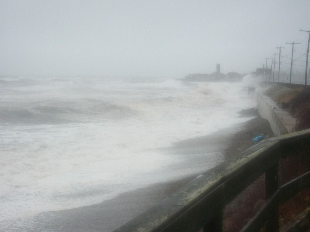
Scituate, like her neighbors in Duxbury and Marshfield, is more of a nor'easter town than a hurricane town. That's actually a worse fate in Massachusetts, as we don't get hurricanes all that much, and the ones we do get break on the South Coast or Rhode Island first.

That matters very little when the waves are breaking on your house, but it matters a lot with these maps we'll be looking at today.

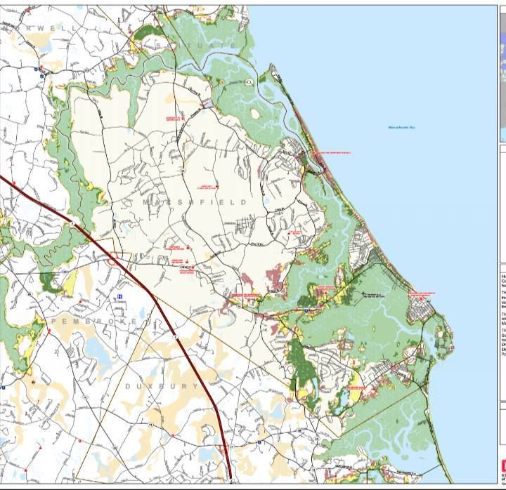
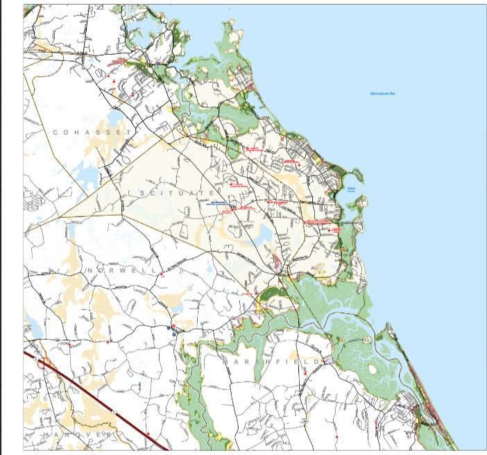
The map above is a Hurricane Inundation Map. It is brought to you today by an amalgamation of FEMA, MEMA, NOAA and NHC. It will be analyzed by ME, for U.

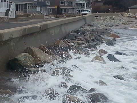
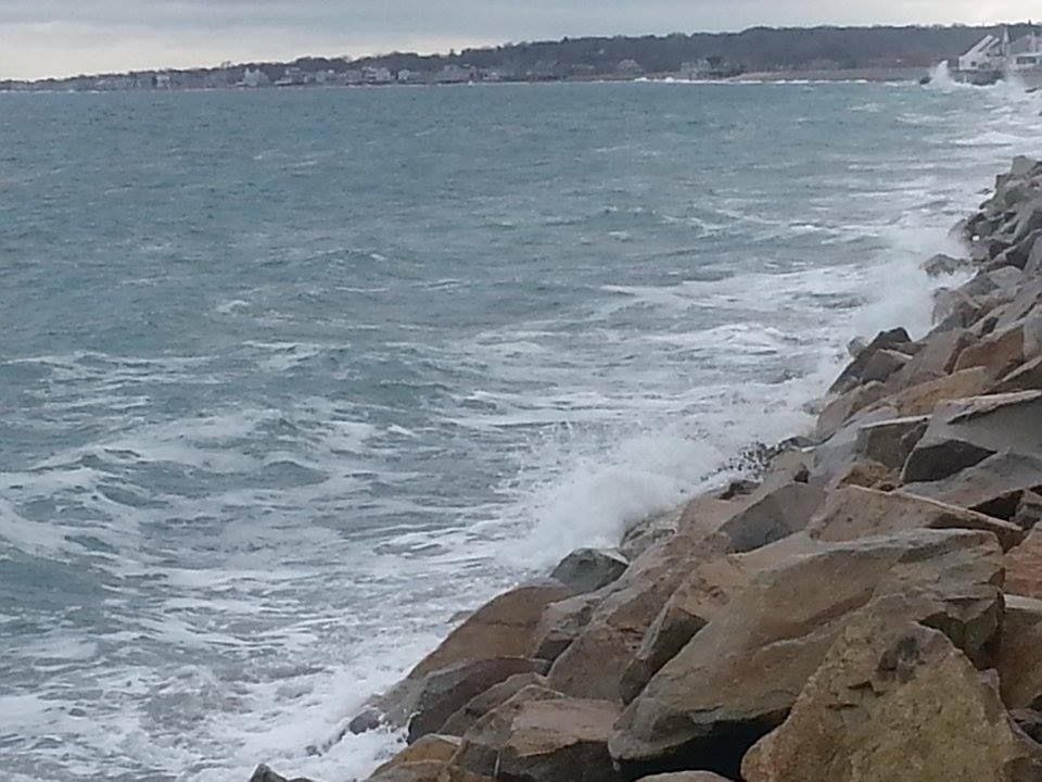
Inundation relates to storm surge, which is the water pushed ashore by a large storm like a hurricane. You can call it the Deathflood or Liquid Doom if that gets your people moving faster. Flooding is the big killer with hurricanes, and it would be an issue in Scituate.

You can use this map to determine what's what in your neighborhood when the flooding starts. It depicts a direct hit hurricane arriving at mean high tide. It does not depict freshwater flooding. They are developed by using the zany-weatherman-titled SLOSH model of storm surge inundation. They also show which intensity (on the Saffir-Simpson hurricane intensity scale) of storm would be needed to soak a particular region.

A direct-hit hurricane would be near impossible for Scituate, as it would have to loop around the Cape and drop back in on you. It's not impossible, according to Bistromath, it's just highly improbable. What is more likely is a Category X storm hitting the South Coast, then moving into Cape Cod Bay to hit Sit Chew It with X-Y. If you see Category 1 for Scituate, you know that Fairhaven probably got Category 2.

Here's how the colors work on the Inundation Map above:

Light Green = Category 1 hurricane. The Blizzard of '78 and the Halloween Gale are good examples of Category 1 storm damage, although neither was directly a hurricane.

Dark Green = Category 2 hurricane. Hurricane Bob was a weak Category 2, and yes we do realize that "weak" and "Category 2 hurricane" are odd words to chain together.

Yellow = Category 3 hurricane. We've only had five storms of this strength hit New England since the Other Man arrived in 1620, the most recent being Carol in 1954.

Pink = Category 4 hurricane. We've had one in recorded history, in 1635.

Flesh = 100 Year FEMA Flood Zone. This is the "hundred year storm" you hear about, although you have to go pre-Colombian to find them. New England was hit by storms greater than Category 4 in roughly 1100 AD, 1300 AD and 1400 AD. They can tell by checking layers of sand on salt marsh muck.

Sorry about "flesh," my knowledge of colors was greatly dictated by the people at Crayola in the 1970s.

You can check these maps in far greater detail by going here and zooming a bit. It's disaster porn, styled to your very home!

Remember, you don't have to get flooded with seawater to die in a hurricane. You can get hit by lightning, sucked into a river, mashed in a road accident, have a tree fall on you, step on power lines, stumble into a sharknado or be killed by looters.

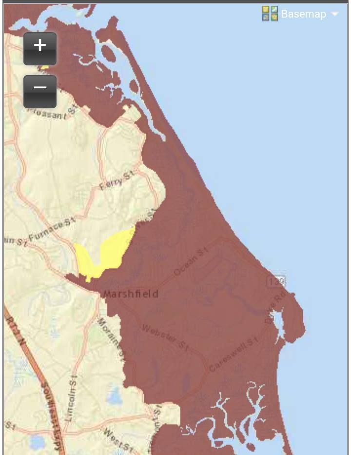
This leads to our second map, the Evacuation Map,

This is the map the authorities use when determining which neighborhoods will be evacuated. You don't HAVE to leave when the police tell you, but you also want to remember that the cop you were reading the Constitution to before the storm might very well be the one who has to make a decision as to whether or not to dive in to the maelstrom after you and your family.

I'm not chastising you. I watched the Halloween Gale from a waterfront home, with the police on a nearby hill blasting a searchlight on us the whole time.

Of course, that was a stupid move, so we'll work the other side now, and tell you about Beating Feet, Hightailing It, and Running Like A Scaled Dog.

This map is easier to follow. It has two colors:

Pink = They have to evacuate.

Yellow = You do, too.

Here's the map:


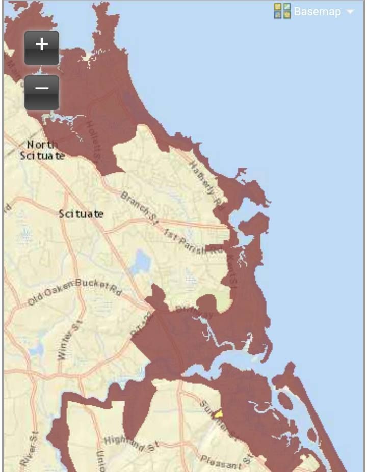
As you can see, Scituate is pretty much Get To Steppin' City if a storm is coming. She's low-lying, and is one of the first towns on the South Shore who get no barrier beach protection from Cape Cod. Much like how they vote in Chicago, Scituate will flood early and often.

Cranberry County Magazine is very much pro-Ask Old People Stuff. If you have some codger on your street who was here for Hurricane Carol, get a few drinks in him and pump him for storm information. Never let the Old School be an unutilized resource, player.

Grandpa may not work for FEMA, but FEMA most likely didn't have someone living on Oceanside Drive during Hurricane Donna. Find out what happened.

No one is going to tell you that Scituate is more dangerous than, say, Lynn.... but if the barometer drops, Scituate is about as bad as it gets. You want to have a rough idea of what danger your house faces, and you want to know if people who study weather for a living would evacuate if they owned your house.

Bone up on some local hurricane knowledge, oh people of Scituate!

Hurricane Inundation Maps

Evacuation Maps

Worst Hurricanes To Hit New England

List of all hurricanes to hit New England


FEMA

MEMA

NOAA

NHC

Cranberry County Magazine wants you alive for several reasons:

- I love showing non-Massachusetts people the written word "Scituate," and seeing if they can pronounce it properly. If Scituate gets wiped off the map, the default towns are Billerica, Gloucester, and Worcester.

- Professional Pride. "If they followed my advice, they're alive."

- Economics. Cranberry County Magazine can not afford to lose one person who opened this page, even if they did so by accident.

- Regular, nice people reasons.


Monday, August 17, 2015

Marshfield Hurricane Primer: Inundation And Evacuation


Where do you start with Marsh Vegas?

It's more of a nor'easter town than a hurricane town, but A does not necessarily preclude B in this case. Marshfield is cap-ee-tull-T Trouble in any coastal storm situation, just because of the lay of the land. That's not going to improve if the winds get over 100 mph.

For starters, they didn't name the town Marshfield because some guy named Marsh founded it. Marshes, moors, swamps, bogs and estuaries all define the town''s geography. You can't be the green-bleeding heart of the Irish Riviera without some bogs to trot on, no?

Marshfield's eponymous marshes and her river mouths (you expect the North River to be trouble, but the itty-bitty Green Harbor River?) ensure that a lot of water will be flowing through and collecting in Marshfield during any rain event. That's before we factor in the waves breaking over houses.

The map above is what they call a Hurricane Inundation Map. It's what floods in town, and note that these estimates are only for salt water flooding. They assume a direct hit (almost impossible in Marshfield's case) from a hurricane at mean high tide.

The map (provided by the NHC and FEMA) is a bit tough to read, as tidal flooding far inland made for a need to zoom the map out. You can still see enough to know, and local knowledge is probably as good as any map.

Of course, your local knowledge isn't top-notch until you can trace your residency back to a signature storm like Hurricane Carol, the Blizzard of '78 or the Halloween Gale. You can always talk up the longest-standing resident of the neighborhood for local flooding history, and any solid plan for a coastal resident should include such considerations.

The light green areas on the map are areas that would be underwater in a Category 1 hurricane. Darker green is Category 2, and yellow is Category 3. Keep in mind, five Category 3 hurricanes have hit New England since the white man arrived. FEMA also provides areas (the reddish shade) that would get hit in a Category 4 storm, which we have not had in modern history. That scenario almost-but-not-quite puts the Dairy Queen under seawater.

The authorities are also nice enough to give us Evacuation Maps. These are a bit more broad-stroked and are much easier to read.

Basically, red means "those people have to go," while yellow means "and you have to go, too."

Marshfield is an odd geographical thing, very close to sea level, and even the high ground drains downhill into the marshes. Areas of Marshfield that shake off a nor'easter with just some frozen spray on the houses may be in for a rude awakening if a Bob-style hurricane unloads on her. Once those marshes top off, the water has nowhere to go except into the neighborhoods.

Much of the area's coast (hello, Rexhame and Humarock) is wedged between the sea and the South River, which only aids the inundation process... which, in turn, spurs along the need to evacuate.

Most of Marshfield's coast- and any areas along rivers or marshes- would have to be evacuated in even a minimal hurricane forecast to hit at high tide. Greater storms would force people near the Fairgrounds to evacuate.

A solid run from the Duxbury border, through Green Harbor, Brant Rock, Ocean Bluff, Fieldston, and Rexhame to the tip of Humarock would be Gotta Goville. I'm guessing, but at the height of summer, that might be 10,000 people.

From what I can see of the maps, people might want to head for the (Marshfield) Hills.

It's like we say on Duxbury Beach... "The other 364 days of the year are beautiful."

If you want to play with the maps or get the links to other towns, maybe see how bad the other suckers near you are gonna get it.... FEMA Inundation Maps For Massachusetts.

You can also window-shop other town's disaster porn with the FEMA Evacuation Zone Maps For Massachusetts.

Marsh Vegas, as you can see, gets wrecked on the regular.


Friday, July 3, 2015

The Dying Of The Light

Duxbury Beach, MA
July 4th is a special day in America. On that date in 1776, our Founding Fathers signed a Declaration of Independence from their English colonial masters. This declaration led to a lengthy Revolution which chased those Limey Poofters back to their silly little island, and it led to the birth of the United States of America.
One thing those Founding Fathers did right was that whole America thing. They did it so well, we're still celebrating. This is Independence Day #239 (ed. note: This is a 2015 article), and we should get a few more in before the Chinese call in their markers.
Until that day comes, we shall celebrate July 4th. The basic plan for celebrating our national birthday was laid down in 1776, by John Adams.

I am apt to believe that it will be celebrated by succeeding generations as the great anniversary festival. It ought to be commemorated as the day of deliverance, by solemn acts of devotion to God Almighty. It ought to be solemnized with pomp and parade, with shows, games, sports, guns, bells, bonfires, and illuminations, from one end of this continent to the other, from this time forward forever more."
The last sentence of that statement is still the basic blueprint we follow today. If you have a bonfire, watch some TV, play some horseshoes, catch a baseball game, hit the gun range, attend Mass, and then go to a fireworks show.... John Adams called that shot 238 years ago, most likely right off the top of his head, too.
Today, we are going to focus on that Bonfire aspect. If you went on Family Feud and Steve Harvey asked you to name ways we celebrate July 4th, "Fireworks" would be #1, "Parades" would be #2... and after that, although it's a close race with "Cookouts," #3 would be "Bonfires."
Bonfires precede America, and actually go back to Caveman times. The English we chased away do a Guy Fawkes fire, and that tradition came to America with the settlers. George Washington himself denounced the practice, calling it a "ridiculous and childish custom." They got away from George's admonitions by just shifting the fires to July 4th.
Now, you may wonder how this tradition was allowed. London, Chicago, San Francisco, Lisbon and many other cities had been destroyed by fire. You are forgetting how hardcore Americans are. In 1903, there were 400 deaths and 4000 injuries nationwide relating to July 4th celebrations, most from children shooting firearms off. It was bad enough that doctors at the time regularly offered a diagnosis of "patriotic tetanus" for early July injuries and deaths. Your second leading cause of Patriotic Tetanus were injuries inflicted by Remember-the-Maine era recreational gunpowder fireworks.
Compared to missing limbs and children with guns, the idea of pushing the local rowdies onto an isolated beach with no combustible vegetation for a bonfire seemed like a pretty good idea. Fireworks were prohibited in most states, and fireworks shows became the realm of the municipality... or the realm of the guy willing to drive to New Hampshire and maybe smuggle back a little somethin-somethin'.
Some towns even took over the running of the bonfires, or banned them altogether. Boston took over the bonfires in 1915, and other towns followed suit. This gave the towns authority over July FOURTH fires, a distinction we'll discuss in a moment.

Gradually, the practice of bonfires faded away, especially in the west and mid-west parts of the country, which were tinderboxy after the Dust Bowl droughts. However, one section of the country, and you can probably guess who it is, held on tightly to the tradition. New Englanders are good like that. John Adams didn't invent those celebrations we quoted him on before. He just described the typical New England celebration.
Salem, known for her witches and hunts, is also known as the town who got the most into it. Cathedral-sized bonfires were regularly assembled on Gallows Hill, as the leftover wooden trash of both the shipbuilding era and the industrial era was regularly stacked and ignited. You can see a ten story bonfire on Gallows Hill right here.
However, Salem's fires were on an inland hill, so- as large as they are- they don't really count. We're talking about beach fires, and July 3rd.
New England's coastal residents resisted the town's claims on bonfires. They didn't beat cops or secede from the towns, although that wasn't very far away in some situations. They just took over a different night. It makes pretty good sense. If the town is having an official fire on the 4th, why not have one on the 3rdSh*t, you have the 4th off, and you need that down time after the 3rd. Gradually, the date of New England citizen fires shifted almost entirely to July 3rd.

I grew up on Duxbury Beach, which has a tradition of bonfires stretching back to her very inhabitation by white folk. You can get stories from the Old School about bonfires 100 feet high in celebration of VE and VJ Day. I can kick it from the 70s (this is Steve, by the way... Jessica, who is from Fairhaven, is visiting family in Florida this week), and our fires were giant and annual. They even did some good.
Beach communities suffer from nor'easters. Nor'easters aren't as bad as hurricanes, but hurricanes don't hit 2 or 3 times a winter. Nor'easters tear down decks, carry away stairs, smash up wooden lobster pots, expel driftwood, and generally clutter up the beach. Beach communities also "suffer" from gentrification, where yuppies buy up old people's summer cottages and build larger, year-round homes.
Much like the people of Salem, Duxbury Beach folk would feast upon the bounty of a bygone era. All of that wood was gathered up, de-nailed, and stacked in a sort of tipi-like structure. We built tipis instinctively, with not a Wampanoag among us. We didn't even have a Hindu-style Indian. By doing so, we cleared the neighborhood of clutter.
I was in charge of bonfire construction by the time I was 10, although by the time I was 10, I was nearly 6 feet tall and was frequently mistaken for a youthful-looking and somewhat slow adult. By the time I was able to drive, I would take a truck around the neighborhood, gathering wood. I would frequently have all of the neighborhood's children following me and helping as best they could. The tallest piece of wood became the center beam of the tipi, and everything else was stacked. I then soaked it in gas (even at 10 years old, I was in charge of this... remember, this was the 1970s) and ignited it by firing a Roman Candle into it from 20 feet away.
I later learned that I was not trusted with this responsibility because of the strength of my character, but rather because I was too young to be tried as an adult.
The town barely interfered. A cop- usually the late, great "Dirty" Harry Levine, who was a teacher in town during the winter- would wander over as the huge pile of wood began to appear on the beach. He made a point of loudly appreciating that we had a crew removing nails from the wood. He also would state that bonfires were illegal, the charge would be Disorderly Conduct, and that he would arrest us in an instant if he saw us lighting it. Harry also had 6 miles of beach to patrol, and you could easily track his location if you gave a kid some binoculars. Once he was X miles away at low tide, we had X minutes to assemble and ignite the conflagration.

Throw in a wealthy neighborhood (the typical ritual was that every house kicked in a $100, and someone went to New Hampshire... although my Dad was a Dorchester kid, and got his fireworks the Old School way, in Chinatown), and placid Duxbury Beach for one night would resemble Fallujah. The wood supply was enough that a mile stretch of Duxbury Beach and Green Harbor might have a dozen 25 foot fires, and copious fireworks explosions completed the illusion.
Duxbury Beach on the 3rd of July is probably my favorite place on Earth. I'll be there tonight, good Lord willing. The Lord is going to weigh heavily in tonight's celebration, as a dry neighborhood of wooden houses and crisp vegetation will host a series of drunk-powered fires (the passing of the Baby Boom emptied the neighborhood of children, and we tend to have smaller fires in larger quantity) as a stiff wind blows the sparks at the houses. Only the grace of God will keep the sparks off of the roofs, although the sea breeze goes away if you wait until dark to light the fire.
The funny part of the drunks-building-bonfires dynamic is that there has never been a fire related to the July 4th celebrations. Duxbury (the town) had their own fires for a while, and nearly torched the elementary school once in the late 1980s. Yes, a bunch of children and drunkards have never neared causing damage with their fires, while the town's DPW and fire department nearly burned down a the school and the library.
Other towns are not as fun as Duxbury.  Marshfield nixes fires, although it's a big town with a lot of beach and the locals still blaze one up now and then. Hull, Cohasset, and Kingston also disallow them. Quincy is in the papers this morning, as the fire chief is weighing the possible outcomes of drunken Hough's Neck fires in high winds near a densely packed urban area. 

Plymouth still has fires, as Manomet bonfires go back to the 1800s, and White Horse Beach can claim a 1777 starting date. Plymouth tried a ban in the 1980s, and police were pelted with rocks and fireworks by locals who didn't get a say in the decision to ban. Civil disobedience acts like building a pallet structure and not igniting it as an homage to bygone days began to spring up.Scituate made the papers when they put the Whammy on bonfires, and Humarock almost seceded from the town over it after police roughed up a 70 year old man in a confrontation.
I never made it to the Cape for the 3rd as a kid, and thus am publishing South Shore stories in a Cape Cod paper with not a single idea of how Cape Cod gets down on the 3rd. I suppose I can call some police departments, and maybe I will, but I don't like to draw attention to myself.
OK, I called Bourne PD, got a befuddled dispatcher, and she said no fires, no permit for fires, and she wasn't sure if any neighborhoods frequently violate the law. I'd guess that Scusset Beach might try something. Monument Beach, PocassetCataumet and Mashnee are also fine spots for a little civil disobedience.
I called Sandwich, and it went straight to voice mail. Same with Falmouth. Brewster had an operator who transferred me to a Captain (while on hold, BPD plays rock music over the phone to me), and I went straight to his voice mail. I wasn't going to call 911 over it, so you'll just have to take your chances, people.
Duxbury, in theory, allows a bonfire with a $25 permit. I don't live there now, and I'm not sure who builds the fires on Duxbury Beach these days. Maybe I'll get to see the cops beat down some 2015 version of me. I'll get a few laughs out of it, but I'll also feel a bit winsome, as I'll be watching a centuries-old tradition die in front of me.
"Rage, rage against the dying of the light."