Ladies and gentleman, friends, Romans, countrymen, and children of all ages.... we proudly present to you the Fairhaven Hurricane Primer!
We're here today to tell you what parts of town will flood, how bad of a storm would be required to flood them out, and where the authorities will be evacuating people. This article will make you expert in all that stuff.
To be 100% cool, you want to either A) draw upon your knowledge, gained from you being in Fairhaven for a signature storm like Hurricane Bob, Hurricane Donna or even- if you're 0ld/old- the Great New England Hurricane of 1938, or B) talk to an old-timer who lives near you and has all that Bob/Carol knowledge down in his memory.
Local knowledge is immeasurably important. I study weather, I grew up on a Massachusetts beach, I live on a beach off Buzzards Bay now, I date a Fairhaven girl and visit her home beach once a season or so... and I still don't know Fairhaven in my bones. I have just this morning found out that I can't say the word "Fairhaven" properly. I say "Fair-haven," which audibly makes two words of it. My girlfriend, who grew up on West Island, says "Fa'haven," which is somehow less than one word.
I have a lot of scientific knowledge, and I have some informative maps to share... but in the end, you don't want to finalize your plans before you talk to a wise old local.
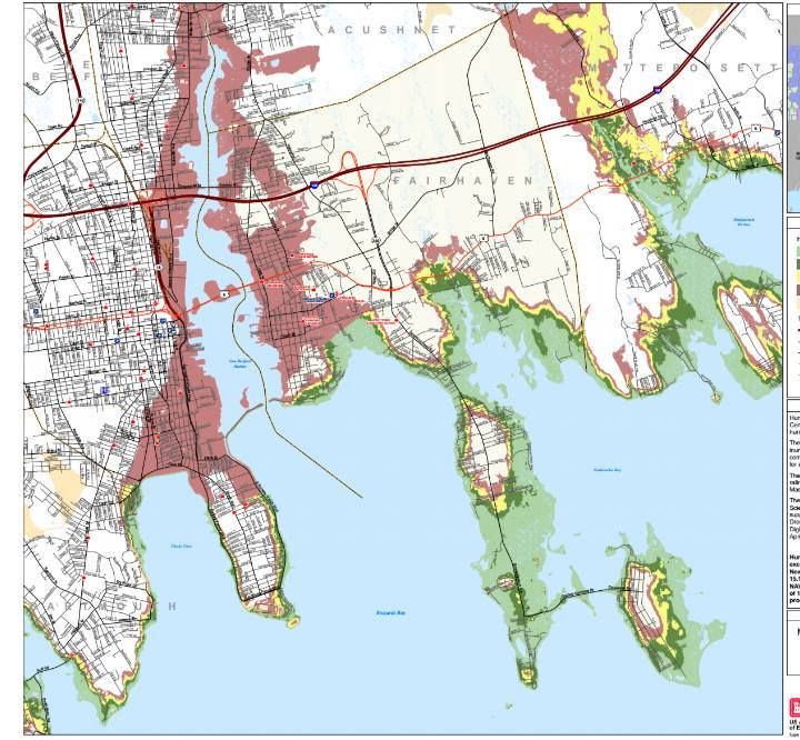
This map is what they (FEMA, MEMA, NOAA and NHC) call a Hurricane Inundation Map. It projects where the storm surge will go, and what intensity of storm would be needed to reach certain areas. They are based on the aptly-titled SLOSH model of inundation forecasting.
Storm surge, as you know, is the water pushed ashore as a big storm hits. It is the big killer in hurricanes, and even in history. The worst disaster related to lives lost in US history wasn't terrorists with planes or an earthquake, it was the storm surge associated with the 1900 Galveston hurricane.
OK, I think Antietam has it beat, but I digress...
Storm surge can also be called a Deathflood or Liquid Misery if that gets your people moving quicker. Either way, it's what those colors on the map above are showing. The differences in color depict where a more powerful storm (power = Saffir-Simpson hurricane intensity scale) would be required to inundate an area.
The maps depict a direct hit from a hurricane at mean high tide. They do not and I repeat NOT account for freshwater flooding, river swelling, sewers overflowing, and 7 inches of rain.
Your colors:
Light green = Category 1 storm. Hurricane Gloria would be a good example of a Cat 1. If you worked your way over to Fairhaven from the South Shore, the Halloween Gale would be a good example of a strong Category 1.
Darker green = Category 2. Hurricane Bob was a moderate Category 2 hurricane ("moderate" and "Category 2 hurricane" are tough words to string together, but that's how they roll at the NWS) upon landfall in Rhode Island.
Yellow = Category 3. Only 5 storms of this intensity have struck New England since the Other Man arrived in the 1600s. The most recent was Hurricane Carol in 1954.
Red = Category 4. We've had one storm of that intensity, the Great Colonial Hurricane of 1635.
Flesh = 100 year FEMA estimates. I presume this is the "100 year storm" that you hear about, and we haven't had one in modern (read: "white guy") history. "Flesh" is my non-artist word for that color, and is drawn from my Crayola days, before Crayola realized that black kids liked to color, too. It may be "apricot" or "off-whitey" these days, I'm not 100% sure.
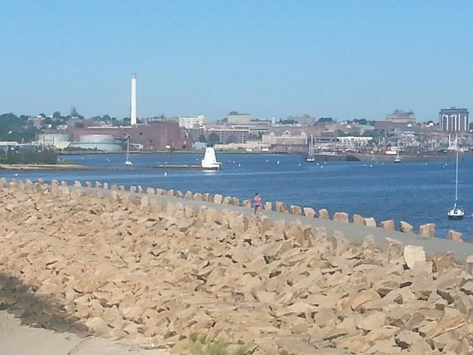
Inundation-wise, Fairhaven is indeed A Tale Of Two Cities (and a few island/peninsula things). You have the area by the Acushnet River. This would normally be a death zone, but they built a hurricane barrier (seen, from what I hope you notice is the Fairhaven side, in the picture at the beginning of the article) at the river's mouth. That protects everything behind it from anything other than a biblical, build-an-ark style flood. We may be wrong, but SLOSH says that only a Cat. 4 storm can get past it.
A storm in the Cat. 4 range wouldn't flood a large % of Fairhaven, but it would flood the area where most everyone in Fairhaven lives. That means we're evacuating about 15,000 souls. We'll get to that in a minute.
The other part of Fairhaven, which is a nice way of saying "the part without the 20 foot stone wall built in front of it," doesn't have it so good. They'll be hurtin' for certain in smaller storms. You can check your own neighborhood (or laugh at the suckers in other neighborhoods) by viewing the links I'll plop down somewhere in this article.
A pretty bad place to be in a storm would be West Island and/or anything off Sconticut Neck Road. The swampy parts go under right away, and an intense storm would start taking houses. A storm of Bob size floods almost 75-90% of these land masses.
If you live on West Island, you want to do this:
- Go find a topographical map, or zoom in really close on the FEMA map.
- Figure out who lives on the highest ground.
- Befriend that person, and butter them up like a biscuit. You want him saying "Come on in" when you show up at his house in a tempest.
- Have an evacuation plan that not only includes "get to the town-designated shelter," but also "get to High Ground Guy's house." If the only road out gets cut off, he may be your best bet.
A few other things stand out when you look at this map.
For starters, a storm of Bob's strength would cross over Route 6 right about where the Stop 'n' Shop is. A storm of Katrina strength would put most of Route 195 by the Acushnet River underwater. Weaker storms would flood Route 6 and Route 195 in Mattapoisett, in case if you decided to think outside of the box and flee East.
West Island is actually East of everything. I'd ask Jessica about this, but she's at work. Keep in mind, I thought that Fairhaven was where Popeye lived until I opened the Wikipedia. Either way, be off of West Island if a storm comes... even a small one.
If you live in the White section of town (hurricane maps are egalitarian, and I have discovered that "white" sections of town are often poorer, while "colored" sections of the map are usually inhabited by wealthier, less swarthy waterfront home-having people), you might think you're off the hook. Remember that these maps only show storm surge, not freshwater or river flooding... and also remember that trees tend to blow over during storms.
In an Andrew-style storm, every single road leading out of Fairhaven would be compromised to some extent. Even the side streets will be under. That means you can't get out, and it means that help can't get in.
You want to be Ghost before then, which leads to our next map:
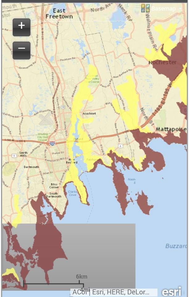
This is an Evacuation Map. It is what the authorities will use to decide who has to stay and who has to go. You don't HAVE to go, but you also don't want to rely on the cop you were just reading the Constitution to risking his neck to pull you out of the maelstrom.
The map is easier to read than the Inundation map. On this map, Red means "they have to leave," and yellow means "you have to leave, too."
This is the cell phone version of the map, you can zoom in for much better detail using the map on MEMA's page.
Route 240 looks like a good evacuation route, even though you'd eventually get pinned in a bad enough storm.
If you live in Fairhaven or if you plan to vacation there, you should have at least the bones of an evacuation plan in place. Fairhaven, unlike other towns we cover, stands in line for a possible direct hit from a hurricane that approaches New England.
We want you alive. We want you alive for selfish reasons, as- if you are reading this and may return- you are our source of revenue. We want you alive for professional reasons, i.e. "If they listened to us, they'd be alive." We also want you alive for homeboy reasons, as one of the founders of this website is a Fairhaven girl, and we consider Fairhaven to be our spiritual South Coast road office. We also want you alive for regular, kind person reasons.

Hurricane Inundation Maps
Evacuation Maps