It is said that, much like how the Eskimo has 200 words for snow, residents of Bourne have hundreds of different classifications for traffic. They distinguish between weekend and weekday traffic, summer and winter traffic, rain/snow/sun traffic and holiday traffic.
Today is one of those subsets... Rainy Memorial Day.
Memorial Day is when summer starts on Cape Cod. Summer people opening their cottages, winter cottage rentals departing, hotels getting summer volume, places with SEE YOU NEXT SUMMER signs un-shuttering, old people smart enough to come off-season arriving... all of the little omens that the locals know of are in effect.
Traffic heading on-Cape was heavy on Friday, Saturday and Sunday. Many of those people have to be on the mainland by Tuesday, and most of them will be making the Drang nach Westen at some point today.
Again, traffic is always going to be bad on Memorial Day Monday. I know it sucks right now, and I haven't opened Google Traffic since I got home from lunch. However, as the list of services offered by the Mustang Ranch in North Las Vegas tells you, there are different kinds of sucking. Allow me to explain.
A nice, sunny Memorial Day means that everyone bails out in the evening, after a day at the beach, a nice dinner and some time spent packing. This has a tendency to put them on the road at the same time. This is where you get those 15 mile traffic jams that Cape Cod is famous for.
A rainy Memorial Day breaks the people up a bit, leading to a heavy-but-lesser flow of the day-long variety. I was writing this article at 8 AM, and there was substantial traffic heading off-Cape even then. Those were the people who saw a rainy Memorial Day coming and opted to bail ahead of the traffic, the Cape Cod version of a guy sneaking out of a Pats game when we're up 42-10 after 50 minutes. Beat the traffic, before it beats you.
Other people, especially those who rented the place they were staying at all weekend, are determined to make a day of it. Cape Cod has shops, museums, galleries, restaurants and all sorts of stuff with a roof over it to pass the time. This tendency to stick it out is not restricted to those who have or don't have children.
Cape Cod will get day-trippers, even with this rotten weather. Some and perhaps many grandfathers who were alive when Hurricane Donna came ashore don't consider this to be real rain, and will insist on hosting a barbecue in it. This effect is limited. We've been keeping an eye on traffic heading both on and off-Cape for most of the day, and there has been no problem at all getting on to Cape Cod.
Even with the people bailing out early, there should be some heavy traffic tonight. The smart people leave early Tuesday morning, but you'll see plenty of the Other Type as you crawl up Route 6 tonight.
We've already had some traffic difficulty, as heavy rains flooded the Cranberry Highway up by the old 99. The road, which was having traffic diverted through the Stop & Shop plaza, is now open.
Note that there comes a time, usually in the Church hours of the morning, where you are under a lesser risk of encountering an impaired driver. Not too long after that, the risk goes up, and it gets to roll-them-dice levels on days where disappointed tourists have been drinking all day.
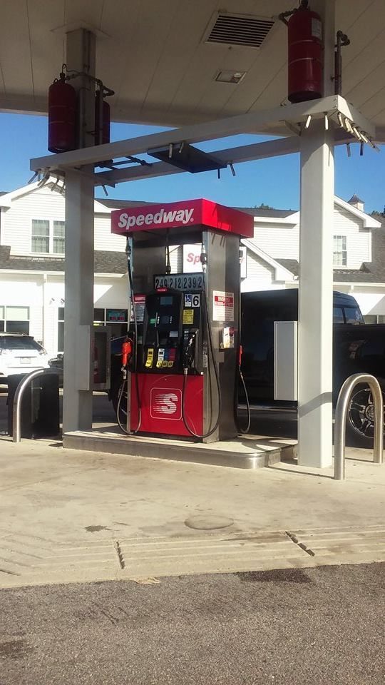
If you must go, don't forget to fuel up! You don't want to run out of gas in a ten mile bumper-y-bumper traffic jam while a tropical storm is pouring water up from Carolina at you. Here are the best (reported) prices for each Cape Cod town.
Eastham: $2.39 a gallon, Tedeschi's, Vandale Circle
Orleans, $2.34/gallon, Cumberland Farms, Route 6A
Chatham, $2.31, Cumberland Farms, Main Street and Roundabout Gas, Main Street
Brewster, $2.36, Cumberland Farms, Main Street
Harwich, $2.32, Harwich Gas And Propane
Dennis, $2.23, Mobil, East-West Dennis Road
Yarmouth, $2.29, Speedway, Main Street and Cape Cod Farms, Main Street
Barnstable, $2.29, Sunoco, Falmouth Road and Gulf, Falmouth Road
Hyannis, $2.26, Airport Gas, Mary Dunn Road
Mashpee, $2.26, Stop & Shop, Falmouth Road
Sandwich, $2.34, Shell, Route 6A
Bourne (Capeside), $2.35, Mobil, Clay Pond Road
Bourne (Mainland), $2.26, Bay Village Full Serve, Main Street
Wareham, $2.23, Speedway, Main Street and Joe's Gas, Main Street
Plymouth, $1.89, Mobil, South Street
3 PM UPDATE: Traffic on Route 6 heading off-Cape is stretched back to Exit 6, while traffic on 28 is jammed back to the Otis Rotary.
Eastern Massachusetts is not without her faults. However, one thing we are not is Ghetto.
Granted, we have Fall River. You can get the Fear nice and easy in Fall River. It's a tough town. Most famous resident? An axe-murderess. Most beloved? Probably the same girl.
Taunton, Brockton and New Beddy are no walk in the park, either... or they're a walk in the park where you get beaten up by a gang of thugs for no reason. After that, there is what skiers call a precipitous drop-off.
Some of the tougher parts of our region aren't THAT tough. I'm not taking about individual citizens. I'm sure there's at least one bad-ass Kennedy (found him!) drawing breath somewhere, and you can get beaten up at the Bia Bistro in Cohasset just as badly as you can get handled at a Fall River Popeye's if you cross the wrong opponent.
Still, if you put on NWA and drive around Brockton, it sort of makes sense as long as your eyes don't go to the rear view mirror at the wrong angle. Try going down King Caesar Road in Duxbury with Bring The Ruckus playing. Your own silliness might strangle you.
There's nothing wrong with this. "Escaping an urban nightmare" is a top reason for moving out to the countryside. "Good visual environment for my Nasty Nas CD" isn't.
Still, if someone establishes a scale for Ghetto, and if the numbers on that scale can be applied to any town anywhere, you can rank towns with it. Lo and behold, that's just what someone did.
They used a simple formula.
Ghetto Bird
Household income levels
High school graduation rates
Number of convenience stores
Number of drug stores
Number of discount stores
Crime
Twitter mentions of #ghetto
It's a flawed formula, but it should be fun to play with.
Here's their Top 15:
Lawrence
Springfield
Chelsea
New_Bedford
Brockton
Holyoke
Lynn
Lowell
Fall River
Worcester
Everett
Revere
Boston
Fitchburg
Wareham
Wareham
Wareham is sort of the WTF on this list, IMHO. I feel badly knowing that she'll be 4th once I start a whittlin' everything North and West of Bristol and Plymouth County out of the master list.
There are definitely some flawed criteria. Twitter references are worrisome. I was a teacher for a while, and I heard kids describe every town on earth as "ghetto." Kids own Twitter, I suppose, and may lack the seasoning to know True Ghetto and why Whitman-Hanson isn't it.
They say that they use "5000 residents" as a cutoff point. Yet, I don't see Duxbury or Bourne or Marshfield or a dozen other towns with populations over 5K. If its a typo and the number is suposed to be 50,000 residents, why is Wareham there?
I was very much looking forward to the bottom of this list, as I wanted to see how the silver-spoon towns fared against each other. It'd be fun to imagine a couple of stockbrokers arguing about whether Cohasset is more thugged out than Sandwich. Alas, the list plays out before we get to the Blue Bloods.
The convenience store angle seems to be ranked right up there with Poverty and Crime, which would to throw a wrench into things. I think that if a Cumby's opens up near the Tedeschi's in your cow town, it shouldn't suddenly make you more Gangsta than someone from Lowell.
Straight Outta Hingham!
However, only my love of Wareham and the lower ranking of Boston makes me really have any issue with the Top 15.
I may get a bit of static from my readers, and I just ask them to remember that I am merely passing along the information on this list. I'm not smart enough to factor that many variables into an equation, even with My Damned Aunt Sally helping. I am smart enough to take a Top 100 list and chop it down to just show the towns in our region, and that's just what we're about to do.
Well, maybe they have some points after all. Some people might flip Fall River and New Bedford, Most people might see the flaws in not having Boston as the anchorman. Larger towns suffer a bit in the ratings, as the sheer number of people make for lower rates.
Wareham seems to be ranked too highly, but maybe they just try really hard. I worked Boston in mostly to knock the 'Ham down a spot.
Our coverage area showed well, taking 4 of the top 14 spots.
Now, remember when I said "precipitous drop-off" earlier. Here we are!
I went to college in Bridgewater, and it's more bucolic than ghetto. A great bit of the town is structured around the fact that there is a college in town. The college is not the only entity in town that may be weakening the stock. As someone on a Bridgewater Facebook page said, "The nuthouse down the road lowers our ratings, as does the mental hospital."
Just kidding, I went to BSC. Class of 2000, blogga!
West Yarmouth? How? Ah, 5% margin of error and all.
Plymouth and Barnstable have their rotten parts, but rarely would one fear to stroll through them. They do the service of grouping their poor into certain areas. Bourne is good at that, too. They stash them right by the highway.
Foxboro is plummeting down the list now that Aaron Hernandez Inc. is within the system. They should sign Greg Hardy.
I wonder if Nantucket is America's most ghetto island? I suppose that Long Island has them beat.
I have no idea what Kingston is doing there, unless the guy who made the list counted Halifax and Plympton's dropouts from Silver Lake as all being from Kingston.
Not to be outdone by the arrival of Sonic onto the South Coast, Cape Cod is importing a national heavy-hitter for a trial run in our local fast food universe.
Chic-Fil-A gained approval from the Cape Cod Commission to open up a drive-thru/eat-in restaurant in Hyannis. The franchise will be will be Chickening Out at the corner of Enterprise Road and Iyannough Road (Route 132). The area was previously overflow parking for the Cape Cod Mall.
Chic-Fil-A (pronounced: "chick filet") is a Georgia-based 1400 restaurant chain which specializes in Chicken. Unlike most fast food joints, I didn't see a cheeseburger on their menu. They use Waffle Fries instead of regular fries. They put pickles on chicken sandwiches, a distinctly Southern thing which I approve of. They also have a chicken-dominated breakfast menu.
I have never seen one of their commercials, so I can't say if their mascot is a clown or a king or a little red-haired girl or even a Kentucky Colonel. If my girlfriend is correct, their commercials are the ones where a cow bothers people while holding a sign that says "EATZ MORE CHICKEN."
Many people only know Chic-Fil-A via their hard-line stance on opposing all things Gay. “To glorify God by being a faithful steward of all that is entrusted to us and to have a positive influence on all who come into contact with Chick-fil-A,” is the chain’s mission statement. Mumbles Menino famously banned them from Boston in 2012 or so. They only use heterosexual chickens for their sandwiches.
Local reactions have been mixed, at least from the section of the community that we sampled. "Praise be to Jesus," said Osterville interior designer Jeff Nonesuch. "I've been searching high and low for a less gay-friendly chicken sandwich."
However, as Hyannis Port retiree (and, she added, former Southerner) Anne Teechikfila said, "I'd sooner hunt and eat seagulls, and that's before you factor in Chic-Fil-A's odious bigotry."
Chic-Fil-A branches are closed on Sundays, which should hit them in the purse in an area of Massachusetts with about a 75 day peak season.
Due to mitigation costs (mostly traffic), the place may lay an egg early if they take off too many peak business days. The Cape Cod Times says that they will have to sell over 81,000 of their $3.49 basic chicken sandwiches just to pay off their traffic mitigation costs.
I do not believe that they will be open by July 14th, Cow Appreciation Day. That's a shame, because you can eat a free meal at any Chic-Fil-A on Cow Appreciation Day, provided that you arrive in the restaurant dressed up as a cow.
We'll let you know when they post their Opening Day date.
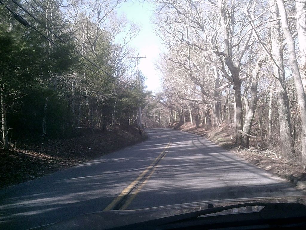
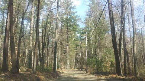
While Jessica and I are finishing up work on the South Coast Compound of our media empire, we thought that we would take to the countryside and see what we could do for you all...
This article could have had several titles. I've erased several of them myself, and Jessica vetoed one. Among those titles that we considered and discarded for one reason or another were:
"Where To Hide A Body In Eastern Massachusetts" "Where To Have A Sasquatch Run In Front Of Your Car" "Where To Teach Your Clumsy Daughter How To Drive" "Where To Smoke A Joint And Drive 27 MPH With No One Behind You" "Where To Illegally Dump Your Washing Machine" "Where Old People Who Just Now Bought The '57 Chevy That They Always Wanted Go To Drive With Elvis Playing And Not Have Modern Kids Laugh At Them" "Where UFOs Look To Scare Isolated Individuals Whom No One Will Believe" "Where To Stumble Onto A Satanic Ritual" "Where To Bet Your Car's Pink Slip On A Drag Race" "Where To Introduce The 'Put Out Or Get Out' Dating Quandary" "Where To Be Mistaken For A Deer And Shot By A Hunter" "Where To Go If You Feel Like Driving But May Have A Warrant Out For Your Arrest"
Among the contributors to this website... Stacey, who is a soccer mom, came up with "stashing a body," "Satanic ritual" and the date rape joke. Her daughter, who is in her teens, came up with the Elvis joke. Non-hunting Stephen came up with the hunting joke. Abdullah, who has no kids, came up with the Clumsy Teen Driver joke. Stephen had Stacey's "Where To Stash A Body" joke as a working title for this article before Jessica intervened.
A nice, isolated stretch of road is a wonderful thing, and it gets more and more rare every passing day. In other parts of the world and even in other parts of Massachusetts, a lonely run of street isn't a rare thing. Eastern Massachusetts isn't other parts of the world, however.
As my friend Beth once noted after leaving New Jersey, "You forget how accustomed you can be to white trash, overpopulation and air pollution."
As people diffuse throughout America, these empty spaces will become harder and harder to find. Our elderly residents can no doubt recall when somewhere with a busy mall used to be a back road to nowhere.
We all have our own reasons for seeking an isolated road to drive on. We listed some up above, you may have other reasons, and no one is here to judge you. We're just here to guide you to some cool places to drive.
We'll use some of those aborted titles as logic for including certain streets in the list, and we will also try to point out where certain practices might prove impractical. We try to be inclusive to anyone who might stumble onto our humble web page, even chronic litterers and serial killers.
So, without any further ado, we give to you but a small sample of some places you can go in our area to have the road all to yourself.
courtesy of Sara Flynn
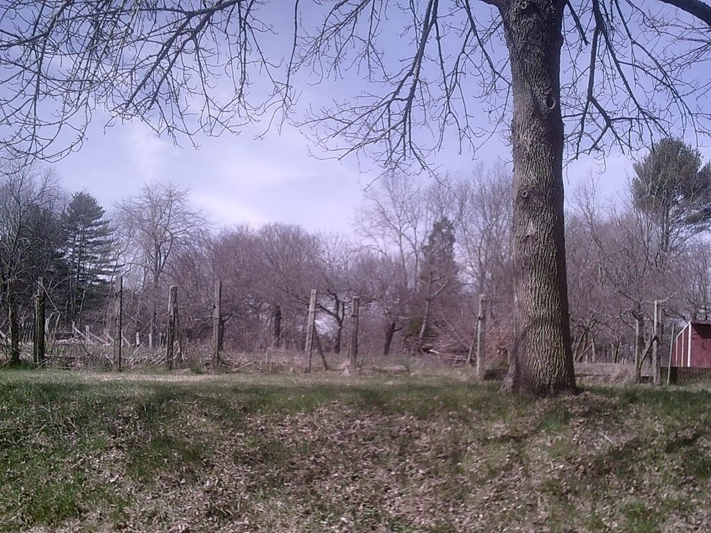
Gurnet Road/King Arthur Road, Duxbury
I use the dual designation here because, even after growing up there for 30 years, I'm not 100% sure where Gurnet Road ends and King Arthur Road begins. Google Maps says KAR juts out just a few hundred yards from Saquish. Other people, maybe more for convenience than for authenticity, use the Powder Point Bridge as the dividing line between the two roads.
Gurnet Road implies the residential section of Duxbury Beach, while King Arthur Road would be very handy for describing the road south of the bridge. However, I'm fairly sure that it is Gurnet Road right up until you get to the actual Gurnet, at which point it gets named after the silly English king.
The differences are minimal, however. What you have here is about 5 miles of sand road, as bumpy as a golf ball, and probably the best coastal scenery in non-Cape Massachusetts. 4WD only, at least once you get to the bridge.
You can very easily pull over on this road somewhere and, if you see no approaching headlights, be pretty sure that the closest person to you would have to swim across Duxbury Bay to say "hello."
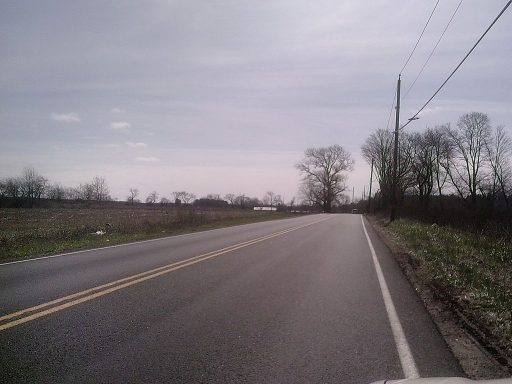
Bournedale Road, Bourne
There is no truth to the story that "Bournedale" is an Algonquian word for "Shortcut." That may have been made up by a Bournedale-area website content generator guy.
Other than a few dozen houses, Bournedale Road is uninhabited. It's little more than some gorgeous scenery, and a way for Buzzards Bay and Wareham residents to get home from Route 3 without messing around on the Scenic Highway.
This road can be fairly busy at certain times of day, but you can have it to yourself if you pick your spots.
This is a terrible road to train a teen driver on. It winds a lot, has numerous high-angle descending S curves and is lined with sofa-sized boulders right at the road's edge. It isn't a very challenging road, but it is very unforgiving.
Added bonus: The Buzzards Bay end of it has a farm stand and a horse farm.
West Wind Shores, Plymouth
Not a lot of people know about this area, as there is really no reason for anyone to use it. "If you ain't from here, you don't come here" applies to this tiny Plymouth village.
Essentially all of Plymouth 1) west of Cedarville, 2 ) south of The Ponds Of Plymouth, 3) east of Wareham and 4) north of the village of Buzzards Bay, it's a unique spot on a political map. You can fire a gun from certain spots in the area and have it be heard in 4 towns, 3 regions and 2 counties.
West Wind Shores is fed by what is either Bourne or Plymouth Road, depending on what town you're in. There are some side roads which veer off into extreme southern Plymouth's lake region.
Where the mentioned-earlier Bournedale Road is a shortcut which Wareham and Buzzards Bay people use to skip the main road traffic when coming and going from Route 3, West Wind Shores is what they use when traffic is bad enough to snarl up Bournedale Road.
If you're reading this to find a place to illegally dump a sofa, this is a bad spot. The road, perhaps owing to her shortcut status, is busier than it should be.
However, once you got the sofa off the road and into the woods a few dozen yards, even God might have trouble finding you.
Just be careful that the locals don't see you... you can get a smack for that.
Glen Charlie Road/Agawam Road, Wareham
It is somewhat interesting to note that of the first four or five roads we mentioned, only Duxbury's contribution is not in a fairly linear run of roads, separated by mere meters of forest.
West Wind Shores, Bournedale Road, the College Pond Roads and Agawam Road are really only kept apart by there being no real need for a shortcut from an isolated Plymouth lakes village to an isolated Wareham one. They wouldn't be isolated if they cut out a road to them, right?
Some people, myself included, even pay to be isolated.
The Myles Standish State Forest and her adjoining regions provide a great portion of the areas we'll explore in this article. It's the Swamp Yankee hinterlands.
Glen Charlie Road, while sticking out into the middle of nowhere, isn't that isolated. If you really need to pour some lime on a former human, you want to veer off onto Agawam Road.
I have no idea who Glen Charlie is/was. I know the road is named after Glen Charlie Pond, which used to just be called Glen Pond. If you know, hit us up in the comments.
Lower/Upper College Pond Road, Carver/Plymouth
That's actually Barrett Pond, not one of the College Ponds. It's off one of the College Pond Roads, so it's good enough.
These roads punch into the Myles Standish State Forest, and you can pretty much go from Carver to the Pinehills on them.
This one is the #1 seed if we break this down to brackets. It is one of or perhaps the only road that goes through the seasonally uninhabited MSSF region. The MSSF makes neighboring towns like Plympton or Freetown look like the lights of Paris.
There are probably some serial killers in the region who have buried two or three generations of victims in this area.
This is as much road as you can have to yourself in Eastern Massachusetts, to my knowledge. It would be awesome for a very brief and hotly-contested NASCAR race. I might have to make some calls.
Old Indian Trail, Marion
This road isn't that long, but it does have the look that we were seeking. I was creeped out driving down it, and it was 2 in the afternoon. There was definitely a chance of Yeti Attack on this street.
There is no Young Indian Trail in Marion, or anywhere that I'm aware of. That might be in regular India.
This was our bumpiest road, and you wouldn't want to try it with an open beer or mixed drink. It's not the road to try in a Dodge Stratus. There were a few potholes on this road in which, if it rained, you could float a battleship around. If your girl isn't having any nonsense and you both know it, this road will at least bounce her around a bit. You gotta take what you can get sometimes, player.
Fortunately, we only needed to go 20 yards from the last house on the street to get the shot above. We went deeper, but that shot did the trick.
Quanapoag Road, Freetown/ Braley Hill Road, Lakeville
There's actually a road or two between Q Road and Braley Hill Road, but the differences will only matter to locals.
This is actually a very nice drive through some beautiful Lakes country. If you're here looking for nice country drives as opposed to somewhere to get rid of a refrigerator, you can do a lot worse. I intend to return with a camera next October, during foliage season.
After researching this project- which for some time had the title Where To Bury A Body In Eastern Massachusetts- one thought kept hitting me. Whitey Bulger used to dump bodies on the banks of the Neponset River. He was about 100 yards from one of America's main highways. He must have been able sit on his own balls.
I suppose some audacity is a must in his line of work, and nobody knew the dark spots of the town better than Whitey Bulger... but we'd be driving 10 minutes in isolation on some roads without being 100% sure that we could get a (theoretical) body out of the trunk and into the ground without being seen, even in a Nowhere Land like Lakeville.
That's why I got into Journalism, folks. I just murder time. Mine, yours, Jessica's... whatever pays.
Lingan Street, Halifax
The lakes region of the interior South Shore has been used as a dumping ground by numerous killers. The killers that I'm aware of used the Chaffin Reservoir in Pembroke and Bartlett's Pit in Pembroke instead of the wastelands at the end of Lingan Street in Halifax. They also got caught.
This road punches through the swamplands on the south side of West Monponsett Lake. It ends at a former campground, if you are willing to circumvent some gates. It looks exactly like where they should have based the Friday The 13th movie.
I used to teach in the city, and I'd take my little Hood Rats out into this area for field trips. Several of my students, far more used to an urban environment, were nervous about being in such a remote area... even in broad daylight.
"This is the s**t where Michael Myers kills all those white girls," one kid from Roxbury told me. "Black people have more sense than to go to places like this." I really couldn't argue with him.
I used to date a girl from Lingan Street. "Date" may be the wrong term, as I do believe that she could barely stand me. She looked like she could scrap some, too. I'm probably lucky that I'm not pushing up daisies at the end of Lingan Street.
Thompson Street, Middleboro/Halifax
You know that you're in the boondocks when you can host drag races on one of the main roads (Route 105, nonetheless) in this area without getting caught or endangering innocents.
I don't want to say that I have gone out early on Sunday morning and seen crude START/FINISH lines painted a quarter mile apart on a straightaway here... but would you look at that, I just said it!
This road is also full of farms. It's a great place to buy flowers, as well as a great place to go if you have never seen a cow in person.
Much like that Camp Murder from the Lingan Street section of this article, this is another spot that I used to field trip my city students to when I lived in Monponsett. Even a genuinely dangerous thug student becomes a cute 7 year old when he sees farm animals for the first time.
This is a beautiful road for the most part. I just shot the scariest part of it.
Will's Work Road, Mashpee
I fished WWR off of Facebook suggestions, and we here at CCM thank the readers for their help.
We'll use WW Road (which I didn't feel like driving to) and this awful screen cap to illustrate a few things this list is looking for.
It's easier if you highlight "Will's Work Road" and Google up the map, but we can see enough here for the basics.
Isolated area? A beach? A marsh? No houses? Minimum expectation of police interference, perhaps a border area of two towns? Plenty of road? Chance of wildlife? In our coverage area?
Will's Work Road, off of Waquoit Bay meets all of those criteria. She'll hold a nice rank on this list if we decide to get competitive.
Oyster Way/Seapuit River Road/Indian Trail, Osterville
This is another reader submission, much obliged!
Oyster Way has a lot of the same features that Will's Work Road enjoys, such as a tidal bay, some nice road to work with and a lot of forest cover.
Working among the wealthy neighborhoods entails a certain set of risks. For starters, you have to get by a gate. Also, the kind of guy who is disposing of a washing machine illegally might stand out in Osterville. Calls to the police will be investigated promptly. There is the chance of video surveillance.
Added bonus: After burying that body, why not unwind with 18 holes at the neighboring Oyster Harbors Golf Club? Not a member? Hey, you've already buried one body today, why shirk at adding a bothersome golf course employee onto your tab with God? God may even take your side on it, there is little guidance in the Bible concerning golf etiquette.
Big ups for being the second Indian Trail to make the list.
Service Road, Sandwich
You could actually classify this as anything between Sandwich and Shootflying Hill in Centerville.
This one requires a Bulger level of testicular fortitude, as you are 50 feet from Route 6 when doing whatever it is that you're up to. However, with the cover of darkness, some foliage... may as well be the deepest, darkest part of the forest, right?
It can also be highly-used, and that usage can spike unexpectedly if there is an accident on Route 6 and people start seeking alternate routes.
This is a nice, safe road that is fine for teaching the teen to drive on. However, the people you do encounter there may be in a great hurry.
Navigation Road, West Barnstable
The Cape is dotted with fire roads, roads that were abandoned after hurricane flooding, Indian trails and service roads. The minor width of the Cape prevents you from getting too isolated, but it can be done... especially in the off-season.
On this road I visualize a guy with every possible sort of infraction on his driving record who just needs "Deer Strike" to win a sort of Irish Lottery with the insurers.
Don't let the name of the road intimidate you... it's a straight line. "Forward" is all the navigation you'll need.
This was another FB suggestion, many thanks! The comments around the FB suggestion include "I drove down there, and my gas tank fell off the car."
Collins Road, Truro
This was the stomping grounds for the Beast Of Truro, who tore up a bunch of livestock in 1981-82.
The Pamet Puma was neither caught nor identified. There were numerous sightings, including one by a Truro policeman.
Some people said it was a pack of dogs, some thought it was a cougar, some thought it was a monster like The Beast Of Bray Road.
He eventually just went away... or did he?
If a monster, mythical or not, roamed your road... your road is going to be on this list, my friend.
Bonus:
Not Massachusetts, but here's what Stanley Kubrick did with the Isolated Road theme....
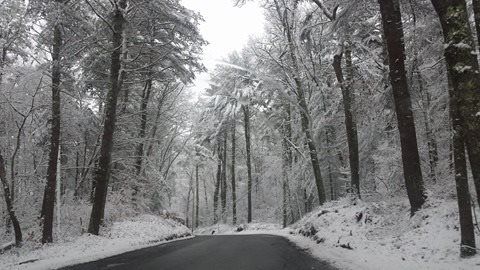
We hoped you enjoyed.... here's some more Duxbury, Plymouth and Halifax , below...
via Kerri Yanovitch Smith
Did we leave any roads out that deserve to be on this list? Let us know!
Sea Glass is made when regular glass gets into the ocean. While finding a whole bottle may be preferable, one generally works with shards of broken glass. They wash into the sea, bang around for a few decades, and gradually 1) get the edges rounded off, and 2) acquire a frosted appearance.
Voila! Sea Glass!
The hunter/gatherer of Sea Glass is someone who finds use for a Cape Cod beach in February. Other than aesthetics, beaches aren't really good for much between October and May. You can surf, but that requires the acquisition of a skill, a wetsuit and a car big enough to carry a surfboard. Even then, you have to wait for days where the waves are large, and- even more then- a shark might eat you. Funk that.
You can still saddle up a surfboard, but you can also walk along the shore for free and keep your eyes looking down. You'll eventually gather up a nice pile of colored, frosted glass, which can be used for various artistic projects.
Don't be intimidated by Artistry. I'm pretty much a complete moron with Art (when I was starting out as a teacher, the inescapable chalkboard artwork which I had to perform was of such a low level that one of my students- her name was something like Hillary Aronson, in case you know her- came up to me after a class and said "Mr. B, next time, just tell me what you want drawn on the board and I'll get up and do it for you. Art isn't your strong point."), but even I can buy a jar and put Sea Glass in it. Leave the jar on a windowsill where it can catch some sunlight... boom, Art.
The hunt can be as nice as the meal with Sea Glass, as- even if you strike out- you still get in a nice beach walk. Other than a greatly-increased risk of toe-stubbing, there's really no downside to Sea Glass Collecting.
This is stuff that you probably knew before reading this article, so what I need to do is some lengthy thinkin' on how sea glass is made, and where someone would be best sent to gather some.
As we noted before, the short answer to the How Is Sea Glass Made question is "glass falls in the ocean, et cetera." However, there are a few things that you should know beyond that.
One, there is some snobbery in the game. "Beach Glass" sounds just like sea glass, but it is not the same, and people will clown on you if you think that it is. Beach Glass is either made in rivers or- for the love of Mary- factories. This stuff is the Fat Girl/Poor Man of the artsy glass movement, and a resident of (or a resident with access to) coastal Massachusetts need not worry about it.
Two, sea glass takes 20-30 years to round into shape. You can't smash a bottle today, walk down the beach a few hundred yards tomorrow, and find a frosted version of the bottle you broke. Nope. You have to wait, for decades in some cases. Certain kinds of sea glass (I'm not sure what kinds, I'm assuming thick glass or something) take up to 50 years before they're display-worthy.
In the 1980s or so, they passed numerous Bottle Bill laws, and those empties are worth a nickel each now... nothing to sneeze at when you drink to the degree that I drink, player. People started returning bottles rather than chucking them, and poor folks would eventually gather up any leftover cold-soldiers to make a nickel per. Right around the same time, those tree-huggin' liberals forced many industries to move away from glass bottles towards the non-sea-glass-makin' plastic bottling. While the beer companies held out, even the drinkers picked up some love-thy-planet stuff from the more conscientious people, and are presently less likely to smash bottles when drinking outdoors.
All of the stuff in the previous two paragraphs means that there is less glass being dumped in the ocean, which means that the sea glass talent pool has thinned out substantially. Population growth cancels it out somewhat, but not nearly enough. The person saying "There was more and better seaglass when I was a kid," is correct, not fooled by nostalgia.
Three, the motion of the ocean is important not only for making the glass, but for moving it about. If glass stayed where you broke it, my local pharmacy would have no Noxema, and I'd have a lamp full of cool blue sea glass culled from my just-offshore stash spot. If you're serious about collecting sea glass- and your author is, at least this morning- you have to research where the currents run, where the rivers empty, where the population centers are, seabed sediment redistribution... and numerous other factors, trust me.
Fourth, know that one piece of glass is not of the same value as others. Typical colors include white, brown and green, the colors of the beer and soda bottles. Lesser-known colors include yellow and blue. Experts can look at a piece of glass and tell you what kind of bottle it came from, and from which era.
Basically, clear = beer, faint green = Coca-Cola, darker green = Sprite, and blue means that not only did someone drink Milk Of Magnesia at a beach, but that they enjoyed it so much that they smashed the bottle in celebration when they finished, like Gronk.
Fifth, you need a combination of timing and luck. Sea glass doesn't weigh much, but it weighs a lot more than sand does. Sand washes around more, and eventually will cover up sea glass. There are some tricks you can do to up your odds, but "needle in a haystack" is actually too conservative a measure for what a glass hunter is doing.
If you can go hunting after a storm, do so. Everything gets turned over, and new stuff is cast forth from the sea.
Finally, much like a mating leopard, you have to pick your spots. Location is everything. You need to identify and exploit certain natural features which are distinct to the local geography. That's where we're headed now.
I was just kidding about Gronk smashing Vap-O-Rub bottles at the beach. Most of our sea glass comes from inland flooding. Rivers rise up, find bottles, wash them downstream, smash them up a bit, and send them out of their mouth into open ocean. The lucky pieces make it back to the beach. The coastal people smash bottles too, but their numbers don't match up with everyone inland.
So, your search should start with a river mouth that empties into Cape Cod Bay or the open Atlantic. The North River, the Taunton River, the the Charles River, the Mystic River, the Green Harbor River, and even the Hudson River will spit out glass that you can eventually collect. Glass can wash a long way from where it started.
Once you have that part done, you have to look at currents. Currents wash the glass to wherever it is going to end up... well, currents and waves, of course. You need to imagine the glass washing into the sea and being directed somewhere by the local currents... currents which, thanks to this handy map, you are now familiar with.
So, you have a glass source, the general direction from the source where the glass went, and now you need to guess where it ended up. This is where I have to invent a geographical term. A "basin beach" is something that sticks out into the sea a bit and collects whatever floatsam and jetsam the sea has to offer. Think of the basin beach as being a big first baseman's mitt, working the current.
Once you're on that beach, look for the area where everything washes up. If a beach has a sandy part and a rocky part, go to the rocky part. Work the fringes of the pile, or go All In and start digging in the rockpile itself.
I actually suck at the collecting, myself. I'm a tall man, and I have terrible eyesight. That's a bad combo to call in on a job where you are looking for tiny bits of glass on a beach, and that's before you factor in the ADHD and the often copious drug usage. What I am good for is helping you skip some of those steps I listed by pointing out local beaches which fit the criteria for a sea glass hot-spot.
Horse Neck Beach, Westport
The Gulf Stream current pushes right up into the body of water known as Buzzards Bay. America's east coast most certainly coughs up a lot of sea glass. Most of it goes out to sea, some of it ends up on Lon-Guy-Land, Rhodey takes her share, but that still leaves a lot of Niceness washing into Bee Bay.
Horse Neck Beach (do not buy into rumors that it was named that because a harlot was lynched there) is well-positioned to get a cut of that action. I suppose that a lot of New York glass washes over here, which should help your numbers out some with ol' Lady Luck.
HNB is also close enough and yet far enough to/from the Taunton River to guarantee a nice flow of glass.
More glass probably goes to the Elizabeth Islands, but mining that involves you getting a boat and stuff. Remember, you're putting broken glass in a jar... let's not ring up any silly expenses.
Speaking of which, the two best spots to capitalize on the Gulf Stream current- Nantucket and Martha's Vineyard- are also eliminated for needs-a-boat reasons.
Old Silver Beach, Falmouth MA
On the other side of Buzzards Bay, we have the town of Falmouth. In the town of Falmouth, we have Old Silver Beach.
I like more rocks on a beach when I hunt, but OSB is very well positioned to get washashore sea glass. If you can get up by Crow Point, do so. It's rockier there.
You may end up in someone's front yard, so be careful. I grew up on a beach and live on one now, so I tend to be a bit unaware of beach restrictions in other towns.
If you find some silver there, even better. Just don't be, like, taking it out of people's beach houses or anything, friends.
Craigville Beach, Centerville MA
Cape Cod, which is a barrier beach for Massachusetts, is also protected by a pair of barrier islands known as Martha's Vineyard and Nantucket, as well as the Elizabeth Islands. These islands, and the multitude of jetties and groynes along the coast (Dennis Port has so many groynes and jetties along the shoreline, it looks like a zipper when viewed from space) interfere with the glass gathering process.
The islands, at a sharp corner of the Gulf Stream, also have odd currents. They sink ships, which is why they dug the Cape Cod Canal. It also messes with the sea glass distribution.
Even if they don't stop the flow of sea glass entirely, the process becomes somewhat unpredictable. We'll give you a southern Cape location to check, but don't say that we didn't warn you.
Craigville sits in a gap between Martha and ACK, and is a nice base from which to operate. She is also basin-shaped, which should act like a catcher's mitt and trap seaglass.
Remember, since you aren't too far from the Kennedy Compound, you might get some high-pedigree glass. I know a guy who lives near Chappaquidick who claims to have red sea glass from Ted Kennedy's brake lights.
Friggin' sweet stopper!
Coast Guard Beach, Eastham, MA
Cape Cod is several different beasts as far as sea glass collecting goes. Buzzards Bay is well-positioned, while the south-facing Cape isn't. Once you turn the corner at Chatham, however, it's a whole new ball game.
I like east-facing Atlantic beaches. A very determined piece of European or African sea glass may have fought her way to America against the Gulf Stream. Who knows? It may have once been Queen Isabella's compact, or Napoleon's Courvoisier bottle, or John Bonham's headlights, or Idi Amin's coke mirror. You never know, stuff like that gets tossed around all the time.
Park and walk north (left) once you hit the beach, to get yourself past the sandbars.
Race Point, Provincetown, MA
RP is one of those gold mine spots. She's also the first beach on our list that isn't getting Gulf Stream in her mix. Most of her sea glass is coming from the north.
People who study currents are already saying "By George! The West Maine Coastal Current aims right at Race Point!" You can't sneak anything up on those people. RP gets stuff from Maine and New Hampshire all the time, including sea glass.Throw in whatever Boston glass washes out that far, and you have a hot spot.
Stellwagen Bank also channels stuff towards Race Point. Note that the Bank, and Cape Cod to a greater extent, slow down waves. This slows down sea glass migration.
Skaket Beach, Orleans, MA
I knew that my kung-fu was superb when my research on which beaches to hit led to a list which matched up with the Sea Glass Ninja Lady from Cape Cast. She admitted that she had no idea why one beach or another yielded better results, but our conclusions match up well.
Inner Cape Cod Bay is a tremendous place to go. It acts as a catch basin for the runoff from the Western Maine Coastal Current. This current is the engine that drives Cape Cod Bay's sea glass movement. Water is pushed along the shore from Maine, past Boston, and into Cape Cod Bay. The fish-hook shape of Cape Cod helps catch the glass as it moves down the line.
Sandy Neck Beach, Barnstable MA
Sandy Neck Beach is a rather long beach, so if you strike out here, you might want to look for easier-spotted things as your next hobby. I'd recommend Lighthouses, it's tough to miss those.
Sandy Neck Beach is a 4700 acre barrier beach, and she is what everything that washes down from Boston eventually bumps into.
You can double up on Sandy Neck Beach. It's where the sand that washes down from Sandwich ends up. Added bonus... when they dredge the Canal, they dump the fill on a beach just west of SNB, and it washes East during storms. Go to Sandy Neck after a full-moon storm, you'll get a lot of Sandwich's sea glass as well.
Scusset Beach, Sandwich MA
The South Shore ends with a THUD as you hit the Scusset Beach jetty. They made the jetty to protect the Canal, but they may as well have made it to catch sea glass.
If Sandwich is being robbed of sea glass, that means someone else is getting extra! Ironically as Hell, I think that this was Mr. Glass' motivation in Unbreakable.
If you want to throw some sand over the jetty towards Sandwich, they'd appreciate it.
Manomet Point, Plymouth MA
P-Diddy is somewhat sheltered by Duxbury Beach, and Manomet Point is the part of Plymouth that sticks out the most into the sea. If you follow the current down the South Shore, MP is what you'll eventually run into.
You're not too far downstream from an oceanfront nuclear reactor here, which in theory would make it possible to look for glowing, irradiated sea glass at night.
If you want to be up the river from the plutonium, try the perfect-for-the-job Long Beach part of town.
Duxbury Beach, Duxbury MA
Duxbury Beach is pretty much the exact shape of the Western Maine Coastal Current, and the current repays the favor by giving Duxbury 5 miles of sea glass hunting territory. Nothing on the South Shore sticks further out into the current than Duxbury Beach does.
You get another 5 miles on the bayside, but the big scores are on the oceanside.
Once you commit, you may as well walk down to the uninhabited part. Less people have worked the territory, upping your chances of scoring big.
If you feel really ambitious, dig into one of the huge rockpiles around the crossovers The good stuff is under the rockpile.
Since I am a former Mayor of Duxbury Beach, you have to give me 10% of your haul, or half of any blue glass.
Egypt Beach, Scituate MA
You'll feel like King Tut after you pillage Egypt Beach, wocka wocka wocka...
Scituate has several beach styles, including rocky, sandy, and marshy. Egypt Beach is what Goldilocks would settle on after dissing the other beaches in town for one sea glass-huntin' reason or another.
You can dig in the rockpiles, or you can walk along the perimeter and pick off the strays. It's Scituariffic!
Nantasket Beach, Hull MA
We saved the best for last!
Nantasket represents two things here. She is the end of the South Shore gold mine, and she is where the WMCC loses her power. That's the bad news. Everything else is good news.
Nanny may hold the title for the region, as she is perfectly positioned to get Boston's glass. She also gets the inland glass, when the Charles and Mystic Rivers spit their bounty out into the sea.
Point Allerton is probably a better spot, but Nantasket is more accessible. The area around the high school is productive, as well.
Much love to Julie Nightingale for the sea glass pics. Sara Flynn gave us the Duxbury Beach shot with the stairs. Jessica Allen was nice enough to shoot Hull for us.
We've been a bit busy lately, hence the low publishing rate. We have a good excuse, though... we're working with a charity!
The Salvation Army has been around since 1865, when it was founded in London. The "Army" part comes from the dedication of the people working there. "I'm no volunteer, I'm a regular!" This sort of led to the naming of the charity, which is broken down somewhat militarily. I answer to a captain and a lieutenant.
I don't have a rank. This is probably for the best, as I'm sort of in the grey area between Lapsed Catholic and Agnostic. I like what they do, however, and they've never asked me about my religious beliefs.
I operate out of the Hyannis corps, and Hyannis services all of Cape Cod. They do a lot of tireless Good. They feed homeless, work with the community, host Mass (they're a church), and make sure that kids get presents on Christmas.
They fund these efforts by a variety of ways, the most familiar of which is the Red Kettle. We all know the guy (or girl, Jessica works with the charity, too) ringing the bell out in the cold, standing next to the red kettle. There is no sales pitch, other than the sign and the bell.
Jessica, Stacey, Cranberry Jones and myself will be working the kettles through Christmas Eve. Be careful with Cranberry Jones, who regards his role as that of Santa's 240 pound collection agent.
We'll be at the Hyannis Stop & Shop on Route 132, at least by noon or so. We'd be there earlier, except that Cranberry Jones has trouble working the CCRTA. Remember, he got his name by a college dare at Yale, where he ate nothing but cranberry sauce for 8 weeks in an attempt to turn his skin burgundy. He is one of the tree's dimmer bulbs.
His heart is in the right place, however... and we hope yours is as well. Hit us up with some Paper Love, and we'll make sure that you at least get Merry Christmas said to you.
Cape Cod is very traffic-driven, as most tourist places tend to be. I lived in Duxbury and Monponsett, and neither one counted traffic as a major town issue. Bourne, where I live now, is dominated by our traffic. Our traffic dictates how residents live their lives on several days of the week, especially in summer.
Our traffic is unique compared to other towns, in that we get people from other states in large volume. Pull out onto Rte. 28, and you'll be surrounded by Massholes, smattering of New Yorkers, some Connecticuts, a few northern Yankees, and a mixed nuts ensemble of people from various other states and countries.
These people are dumped onto a variety of Suicide Alleys, make-your-own-law rotaries, narrow bridges, visibility-cluttering business districts and windy cow paths.
Of course they are going to crash into each other now and then.
The Cape Cod Commission was nice enough to post some stats on accidents that occur on Cape Cod roads. They gathered stats by Number Of Accidents, Property Damage, Crash Rate and Property Damage rate. Long story short, they tell you where you are most likely to have an accident on Cape Cod.
The info is old (2010, updated in 2012), so take anything we say here more as a guideline than as current, absolute truth. The numbers themselves are small enough that a good multiple car crash or two could suddenly jack a middling contender up the rankings into a Trump-like leadership slot.
Rather than slogging through 100 entries with me trying to riff on particular roads, we'll just cherry-pick good stuff for you.
- Remember, the Cape and Islands lay claim to one of America's most notorious car crashes... the Chappaquidick bridge departure that essentially put a ceiling of "Senator" on post-JFK Camelot.
- I don't know which car crash would be the most notorious in American history.
James Dean's death was huge. Jayne Mansfield's scalping is why those little bars on the lower rear end of big trucks are called "Mansfield bars." Lady Diana ate some car parts as a last meal, but that was in Old England (editor's note: France), not New England.
I'm sure that some drunk smashed into a church group bus somewhere sometime, that would get up in the rankings. Tim "Crash" Murray got his nickname wrecking a car. I know what "affluenza" is because of a car crash.
Sam Kinison died in a car wreck, as did Paul Walker. Dale Earnhardt Sr. (even I, a non-NASCAR fan, refer to this man conversationally as "Dale Senior") and Kenny Irwin Jr also died in the saddle.
Any Southern snowfall threatens to add to the list.
- I also found this map with little dots representing car crashes. Just looking at that, you get the sense that the worst spot is the run of Route 28 from Falmouth through Yarmouth. Hyannis, which actually owns cluster-dots, rules the roost.
- Suicide Alley is not impressive at all on this map.
- I consider shattered brake light glass to be a viable addition to a sea-glass collection, as long as the glass somehow made it to the ocean and then the beach somehow.
- These maps need to be viewed in the Gestalt to get the true vibe. There are differences between a love tap and a crash that, say, drowns your secretary. There are also highly-used roads that have lots of accidents, but you then see side streets representing hard if they feature a tricky intersection.
- No one, to my knowledge, has managed to drive off of the Sagamore or Bourne Bridges. Some old-schooler may be able to contest this claim, however.
- Our leader for Number Of Crashes is Route 6, the Mid-Cape Highway. Various sections of this road hold #1,4,5,6 and 7 spots in the Total Crashes rankings.
- Exit 6 on Route 6 (sorry, I don't know which direction) had 128 crashes in this period of measurement. The next highest, Exit 9, only had 99. You're dropping into the 50s and 40s before you leave the top fifteen.
- Bourne, which is the feeder tube for Cape Cod, represents hard. This is even more of a truth when you start getting into Rates rather than Totals. Bourne has the #3, 8, 9 and 13 spots in Number Of Crashes rankings. Her spot with the most crashes is the Otis Rotary.
- I could be wrong, but the rotary Most Crash rankings go the Otis Rotary, the Bourne Bridge Rotary, the Belmont Circle Rotary (Bourne owns the top 3 most dangerous rotaries on Cabo Coddo), the Airport Rotary and the Eastham Rotary.
- Sandwich Road is a dangerous place, even after I realize that there's one in Falmouth, too.
- Yarmouth moves up in the rankings once you factor in property damage costs. Hyannis and Bourne wreck ore cars, but the outer Cape wrecks nicer cars.
- Property damage costs also may be where Suicide Alley asserts herself. They only had 36 deaths there in 10 years or so, but they were head-on, total-the-car sort of deaths. I don't have a Fatality list for all of Cape Cod, which is where Sue might also assert herself.
- Crash Rate is where the rankings get shook up. It is my opinion- and remember, I just started studying this stuff aa few hours ago- that Crash Rate is the best indicator of a dangerous road. Busier roads have more accidents, but they might not be as dangerous. Many more people watched this video than this video, and the size of the pool for Video One may mean that more people were offended by Miley's work than were offended by the Paris video... even though the Paris video is far more offensive. The same goes with roads and inherent danger.
- The Otis Rotary seizes the top spot for Crash Rate, knocking Exit/Route 6 down to 3rd place. Little-used (17 accidents) Route 39 is second. Route 124 is 5th.
- The exit in Sandwich at Chase Road, #9 in property damage totals, is just #47 in crash rate.
- The worst crash I ever saw ws that fuel truck that flipped over into the Bourne Rotary last winter. It had the huge-truck-crashing props, as well as the spilled-fuel aspect. I only moved down here in 2005, though.
- Feel free to tell us about the worst accident you have ever seen on Cape Cod in the comments below.
...WIND ADVISORY IN EFFECT FROM 1 AM TO 4 PM EST WEDNESDAY...
THE NATIONAL WEATHER SERVICE IN TAUNTON HAS ISSUED A WIND
ADVISORY...WHICH IS IN EFFECT FROM 1 AM TO 4 PM EST WEDNESDAY.
* LOCATIONS...INCLUDE CAPE ANN...THE PLYMOUTH COUNTY SHORELINE...
CAPE COD...AND NANTUCKET.
* WINDS...NORTHEAST 20 TO 30 MPH WITH GUSTS UP TO 50 MPH.
* TIMING...1 AM TO 4 PM WEDNESDAY.
* IMPACTS...STRONG WIND GUSTS WILL DOWN SMALL TREE LIMBS AND
BRANCHES...POSSIBLY CAUSING ISOLATED POWER OUTAGES. DRIVING MAY
BECOME DIFFICULT...ESPECIALLY IN HIGH PROFILE VEHICLES.
PRECAUTIONARY/PREPAREDNESS ACTIONS...
A WIND ADVISORY IS ISSUED WHEN SUSTAINED WINDS ARE FORECAST TO BE
31 TO 39 MPH OR GUSTS WILL RANGE BETWEEN 46 AND 57 MPH. WINDS
THIS STRONG ARE CAPABLE OF DOWNING SMALL TREE LIMBS AND
BRANCHES...POSSIBLY CAUSING ISOLATED POWER OUTAGES. DRIVING CAN
ALSO BE DIFFICULT...ESPECIALLY FOR HIGH PROFILE VEHICLES.
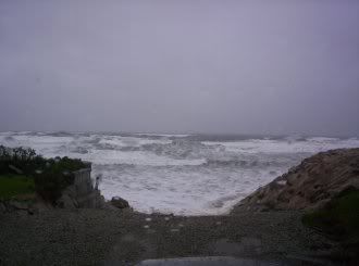
Ten foot tides on Wednesday morning, new moon heights.
Sara Flynn on the camera, Sara Flynn's dog on the stick.
This last storm was fun to take pictures of, but it was a D+ grade storm historically, maybe a generous C if you value Staying Power. The dog enjoyed it heartily.
No one, except the guy I photographed jumping the Sandwich boardwalk on a parasail, is going to look back on this storm in 20 years with anyone who will remember what he was talking about. It doesn't merit historical consideration, other than the tragedy down in the Bahamas with the MMA kid.
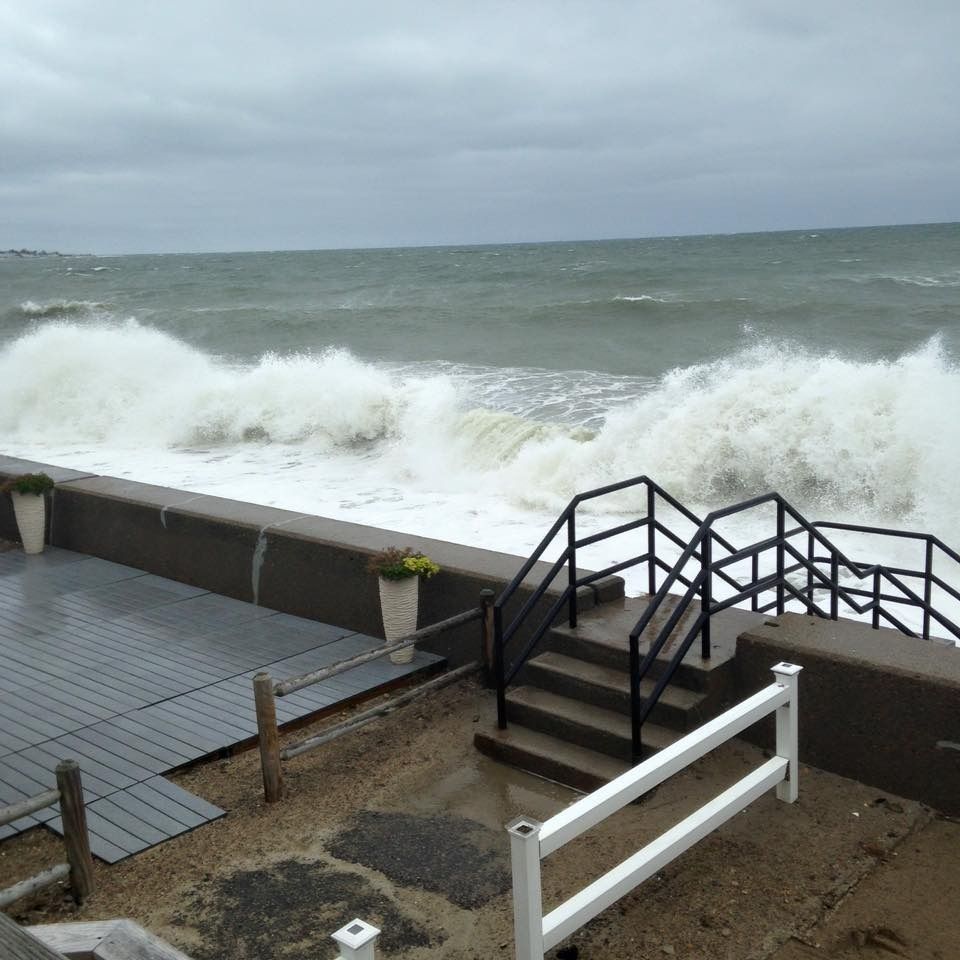
However, even minor storms can mess up the neighborhood pretty nasty, and things will be a bit ugly until Toil and Tide smooths everything over.
We'll try to give you an idea of how the coastal people deal with storms.
This is an old picture, from a 2006 Duxbury nor'easter, To my knowledge, there were no houses torn apart in this last storm.
If the storm is bad enough to take houses, it goes without saying that the cleanup will be lengthier and more complicated.
Some storms can even alter the look of the neighborhood forever. To keep it Duxbury, I can recall the Blizzard of '78 being the end of the road for cottages in front of the dunes. The 1991 Halloween Gale knocked over the last of the 1950s-style cottages, and future gales will put the rest of the neighborhood up on stilts.
Again, this storm wasn't a home-killer. We're just establishing one end of the spectrum for the discussion.
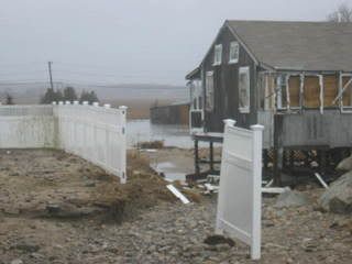
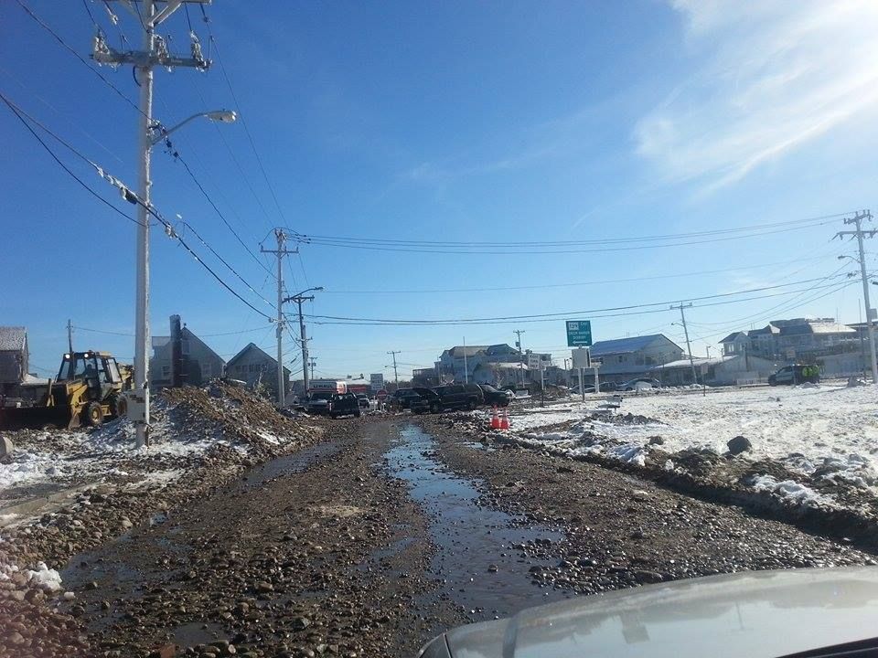
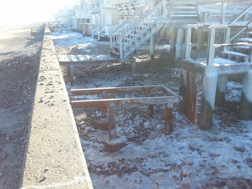
The next level of storm is where the houses are up, but the road is ruined. This is the Ocean Bluff/Brant Rock area, after one of last winter's blizzards. That's not a dirt road, that's heavily-used and trust-me-it's-paved Route 139.
The ocean, when it moves from shoreline to street, isn't just water. It is moving large piles of sand and stone with it, as well as anything that might be in the yard of whoever owns the land the ocean is washing through.
When I was trapped in my house for the Halloween Gale, you couldn't stand in front of a window, even on the second floor, when waves were breaking on the house. Each wave would slam a Shirley Jackson story worth of stones off of the house. That's why you board the windows up, player.
Those stones also wash past the house, and that usually puts them in the street.
Sand also shifts, remember...
This was the most damage I saw working the Sandwich-Barnstable-Yarmouth-Dennis run during the storm last weekend. Some DPW guy can sweep that ish back up onto the dune or whatever happens to it in this town.
Duxbury usually has the other sort of problem, with the ocean slicing through from ocean to bay. That makes parts of Duxbury Beach- as well as Saquish, where people live- into islands. Most of the town's effort after the 1991 storm involved making the beach whole again.
Otherwise, people get cut off, supplies get low, panic ensues, and the people from the Gurnet rise up and slaughter the people of Saquish for food and goodies.
Even tony Sandwich takes her lumps now and then.
Sammich is located on the wrong side of the Cape Cod Canal jetty, and it gets very little replenishment sand from more northern towns.
Prior to the construction of the jetty, this was the sole benefit that Sandwich gained from nor'easters. Once the jetty was up, Sammich was having sand washed down the beach from them without getting any sand washed down to them.
This eventually leads to large chunks of Sandwich being claimed by the sea. The sea then starts touching things that she isn't supposed to be touching, like highways.
It's probably not going to come to that on Route 6A, at least from what I saw this weekend. There were some houses taking shots, and I'd bet that they lost a lot of sand.
If the street an the beach got messed up, you can bet that the wall that was supposed to be protecting the street has been compromised.
Seawall repairs are ugly business, for several reasons. One, if you need them, you most likely just had a damage-doin' storm. Two, seawall repairs are costly, with coastal towns sitting on potential seawall repair bills running into the millions. Three, there will almost always be a fight between homeowners, the town, the state and the US of g*d-damned A over who will be footing the bills for the seawall repair.
I am related to at least one guy who had to run down to Town Hall and wave deeds and contracts in their face before getting off the hook for thousands of dollars worth of seawall repairs that the town was supposed to pay for.
You have to watch the towns, as they try to get off "cheap" on the repairs now and then. Duxbury, which can hardly plead poverty, had a wooden seawall until the mid-1950s.
This is more of the Brant Rock/Ocean Bluff damage from last winter. If the elements and the budget won't let you build a fancy seawall, a bunch of boulders will have to do.
You just want something tall enough to slap down even huge waves, and you want it heavy enough to not be washed away when the Atlantic Ocean leans on it. If a little bit of water gets by it... well, hey, you live at a beach, right?
If you don't build a seawall, the ocean gets to tee off on you for 5-12 waves a minute for 3 hours of nor'easter tide, twice a day, any time the pressure drops. You want to try to avoid having that happen.
Seawalls are like divorces.... they cost so much because they're worth it. The town and state will complain, but it will get fixed in the end. The alternative- again, like the divorce- is too ugly to countenance.
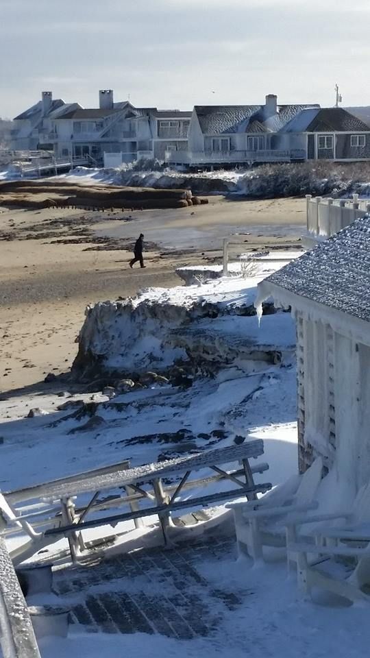
The seawall houses in Duxbury are known for their beautifully maintained lawns and just-like-God-planned-it soft sand yards. Oh, wait... this is a post-blizzard shot of Duxbury Beach.
I swear to God that one of those houses in this picture above (the foreground, with the ice) is owned by a golf course groundskeeper, and his lawn is kept at putting-green-trim levels all summer.
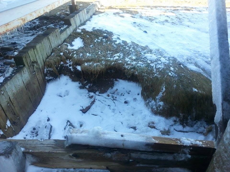
In order for that to happen, you have to shovel (or hire someone to shovel) the beach back on to the beach. My yard on Ocean Road North would pick up what I would conservatively estimate to be 1000000000 rocks every nor'easter.
Rocks are handy to have around if you, say, need to fill large holes in your lawn.
Once the yard is cleared, it must be repaired.
Even after you fill the large holes (snow doesn't count, lazybones!), you still have problems. All of your grass has been washed and soaked on salt water.
The Romans, after razing Carthage, covered the ground with salt and sea salt. They salted it down because, as Sam Kinison said, "Nothing grows in sand, nothing's gonna grow in sand!"
Grass is no exception, which is why beaches tend to be sandy. If you want the grass back after a storm ruins it, you have to skim the top layer of soil and replace it with unspoiled topsoil. Then you plant the grass, and then you see if you removed enough salty soil.
This is why some people say "Screw lawns," and just go with natural sand yards. It turns out that these also require tireless maintenance. I did that with the patio near the seawall, as we would lose the front 10-20 feet of lawn with every storm.
This wonderful beach scene, as we noted in a previous article, would be perfect sand-water-dunes-lifeguard chair Cape Cod if this were not the parking lot of Sandy Neck Beach.
It'll all wash away at some point. It's marshy over there, and the DPW can sweep up and re-deposit that sand where it belongs. A parking lot is less of a touchy maintenance job than that of a million-dollar Hyannis Port beach house. You can't just let the Kennedy Compound drain, and then hire some townie to sweep it up whenever.
This can be touchy with October storms, as no coastal resident with any brains makes yard repairs on the nor'easter damage until late April. June through October is hurricane season, but October through the Ides of April is noreaster season, and we get several storms a year.
The beach suffers during those storms. People like the natural aspect of a soft-sand beach, in theory. In reality, "natural" beaches look a lot more like the picture with the dog at the beginning of the article.
The tide will take care of the lower beach, but the upper beach can get a little bit ugly.
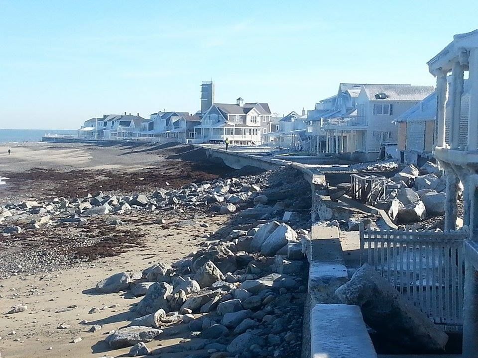
Anyone who lives on a seawall knows this scene, represented perfectly by Duxbury Beach.
Several somebodies let the storm sneak up on them, and didn't take their stairs up (in the local patois, stairs are taken "up" onto the seawall, as opposed to being taken "down" from the seawall) in time. The stairs bang around in the surf until there isn't a seawall to prevent them from being tossed up past the wave-wash.
Eventually, you sneak on the beach with a Jeep (the "Duxbury Cadillac" of legend, in case you heard the term and never knew the reference), tow the stairs back to your house and hopefully store them a little more securely.
Duxbury Beach gets lots of odd stuff washing up. Every now and then, a barge loses a cargo container over the side, whch busts open and disgorges her contents into the sea. They eventually wash up on the beach somewhere. One winter, it was oil filters. Another winter, it was Nikes. If they had EBay in 1980, I would have sold more sneakers than that Air Jordan motherf***er.
Lobstermen get caught slippin', too.
For reasons I don't know but that some salty dude (or dudette, the only lobsterman among my Facebook friends is a girl known to me as Tornado) could tell us, wire pots don't wash ashore as much as wooden pots do.
When I was a kid, we'd go out after every nor'easter and snag lobsters out of the wooden traaps that washed ashore. We'd get several dozen this way, as pots, buoys and so forth were all over the beach.
You never steal the pots, however, and even the buoys were a rough proposition. I don't know if lobstermen can shoot you for touching their gear, but I know that many think they can... and that's all that will matter if the heat comes out on you, friend.
This is the Mystic River, courtesy of Paul Walker... no, not THAT one.
While this isn't ocean damage, what you see here are leaves. Those leaves, still green, should be up in a tree, getting ready to be in my fall foliage shots.
If those are lily pads or something, just try to work with me here.
Massachusetts, and especially Eastern Massachusetts, doesn't really get around to fall-foliaging until late October. Some places on Cape Cod (I noticed this while bell-ringing at the Sagamore Christmas Tree Shoppe) don't even go over until mid-November.
That overlaps with the October-April nor'easter season, and is one of the many reasons why coastal Massachusetts isn't really top-notch foliage country. We rock pretty hard compared to, say, New Mexico, but New Hampshire people laugh at our foliage... they LAUGH at it.
Of course, they don't have ocean storms up there, so they can just shush now.