Thursday, April 6, 2017

Right Whales Moving Into Cape Cod Bay


Massachusetts has rites of Spring, just like Iowa, Arkansas and Colorado do. Some of our rites involve whales coming for a visit at a certain time of year, just like they don't in Iowa.

North Atlantic Right Whales are entering our waters as we speak. They come in after plankton, using some primordial algorithm to know when the water temperature is just right to chow down on the microscopic organisms.

Right Whales are as rare as it gets, and are especially rare for both large whales and marine mammals in particular. There are only 500 left in the world. At the moment, 71 of those have been recorded as being in Cape Cod Bay as of Wednesday.

A mother and her calf were spotted in the Cape Cod Canal Tuesday, and another mom/baby were seen in Cape Cod Bay about halfway between Provincetown and Marshfield. Experts expect many more in the upcoming weeks.

 The whales cruise the surface, filtering tons of plankton into their tummies. They often work very close to shore, and are visible to beachwalkers. Set up on a cliff (Manomet, Cedarville, Scituate, Saquish) if you can, height always helps when spotting. It involves more "getting lucky" than me getting laid, but even a bad day staring at the ocean is better than most good days.

It goes without saying that you shouldn't hassle these whales. They are very rare. Boats are required by law to keep a few hundred yards between them and any righty. A collision between a whale and a boat could take an endangered species off of the charts.

It's also good sense for the mariner. Look at how things ended for Captain Ahab, Quint, Joshua, Samuel L. Jackson... you don't want to mess with anything that can fit you in their mouth.

Tuesday, April 4, 2017

Flooded Cranberry Highway Impassable In Spots


Route 6/28 through Wareham, aka The Cranberry Highway, is impassable for all but the highest-profile of vehicles.

Drenching rains are pouring down on the 'Ham, and the area in front of the old 99 is an urban river.

This is the second time this week that the Cran has been too flooded to drive through. Any good rain does it these days.

Note that this is a major evacuation route for Buzzards Bay and Wareham, especially Onset, in the event of a hurricane. You'll want to get ghost early if your evacuation plans include East Wareham,

We'll be back if an update is necessary.


Click the "East Wareham" link at the bottom of the article for the map location of the flooded road.

Sunday, April 2, 2017

Vampire Panic In New England

New England is home to Harvard, Hawthorne and a lot of US Presidents. We have intellectual stripes that few states can match.

We also would blame tuberculosis deaths on vampires and desecrate corpses to kill them now and then.

New England had a period running from 1784 through 1949 where 80 bodies were exhumed from graves to be treated as vampires. Various folk-remedy methods of vampire extermination were utilized.

This wasn't medieval stuff... a vampire was exhumed in Rhode Island about 20 years before Ronald Reagan was born, not too long before the Wright Brothers got an airplane off the ground. This was 200 years after the Salem Witch Trials. People were living during that exhumation who, in the same life, watched a moon landing on TV.

What's up with these people? What's the dilly? As you might imagine, several factors were at work.

Understand that the Internet sucked in 1892, with "sucked" meaning "didn't exist." Literacy, while on the upswing from near-zero in feudal times, was still a rare thing, especially in rural communities. The newest medical journals were slow to get to western Rhode Island farms. Doctors were rare, many were quacks, and even President McKinley had a doctor check a bullet wound by sticking a finger in his abdomen and poking around... in 1901.

If educated city-folk were that dangerous, you can imagine how much damage a farmer could do when faced with a disease or infection that he had no idea about.


Tuberculosis was only really figured out recently, and doctors would just throw up their hands when they saw it in 1892.  Their cures were often worse than the illness- Doc Holliday was sent to a sulfur spring to treat his tuberculosis in 1887.

Rhode Island farmers had even less understanding of tuberculosis, which they referred to as "consumption." The name was fitting. A person with tuberculosis would lose weight, become pallid, refuse to eat, fear light, labor to breathe... they wasted away before your eyes. It would also tear through families, many of whom were piled 8 deep in a house and sharing one bed.

While a doctor might recognize this as tuberculosis, a farmer would have a different diagnosis set. It might include the spirit of a deceased relative leaving the grave and feeding on the life energy of their surviving family.

Belief in vampirism goes back to Mesopotamia, and was still in effect in many parts of the world by 1892. This was before Bela Lugosi and Twilight, so no one thought of a vampire resembling a Hungarian count or a pouting teenage boy. When it wasn't being described as a sort of energy force, a vampire was viewed as more corpse-like than a Brad Pitt-looking fellow.

While a diagnosis of vampirism might get you laughed out of Tufts, an illiterate farmer might think that it sounds as good as whatever the city slicker was telling them. You have a definite cause-and-effect thing working, always valuable to a man playing doctor who can't read. A diagnosis of tuberculosis requires medical knowledge and intense examination. All you need for a Vampirism diagnosis is for the TB to run through the rest of your family.

Consumption happened a lot in rural communities. It was the leading cause of death in the northeast in the 1800s. To their credit, most farmers recognized it as a natural illness without paranormal overtones. That's why farm families crank out so many kids. Children are Labor, and even Dowry. They are also vulnerable, which is why many farmers banged out 12 kids in hope that 5 would survive to run the farm.

However, historians have uncovered at least 80 instances where corpses were exhumed and desecrated because someone thought that they were vampires.

Cases run from Maine to Minnesota , but New England holds the title. We do have places like Yale and enlightened cities like Boston, but we also had many areas chock full of susperstitious farmers.

We are also heavy-handed with the punishment. We performed the first legal execution of a juvenile in America... for Bestiality, I believe.

That tendency towards draconian superstition, much of it brought over from Europe, gave New England the title belt with both Witchcraft and Vampirism.

There's a good reason why Shirley Jackson didn't set The Lottery in Manhattan, and why Stephen King set Salem's Lot in Maine. The stories work here.

A relatively isolated area in Rhode Island and Connecticut could do a pretty good Salem's Lot impression, as a great % of the recorded Vampire exhumations went down there.

You can't blame them totally- there was a prominent exhumation in Vermont in 1817, Thoreau wrote about one in 1859  and even America's Hometown of Plymouth has someone buried face down to prevent them from being able to dig their way out of a grave- but they were into it the most.

A newspaper from Connecticut in 1784 denounced exhumations. The Tillinghast family of Exeter, which saw consumption run through it after the father's 1790s dream of a blight killing half of his orchard, lost half of their children even though they exhumed 17 year old Sarah and did a ritual. Jewett City, Connecticut, Saco, Maine (15 miles from where Salem's Lot was based), Loudon, New Hampshire, Belchertown, Massachusetts, Woodstock, Vermont, Cumberland, Rhode Island, Manchester, Vermont and Griswold, Connecticut- among dozens of other New England communities- went all Buffy on someone in the course of their histories.

Exeter, if not the epicenter of the vampire craze, serves as the main neighborhood. They acted like Serbian gypsies. They also are notable for their brutal exhumation techniques, their near Reagan era survival of vampire superstition and for being the home of America's vampire queen.

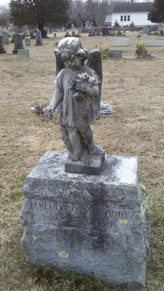
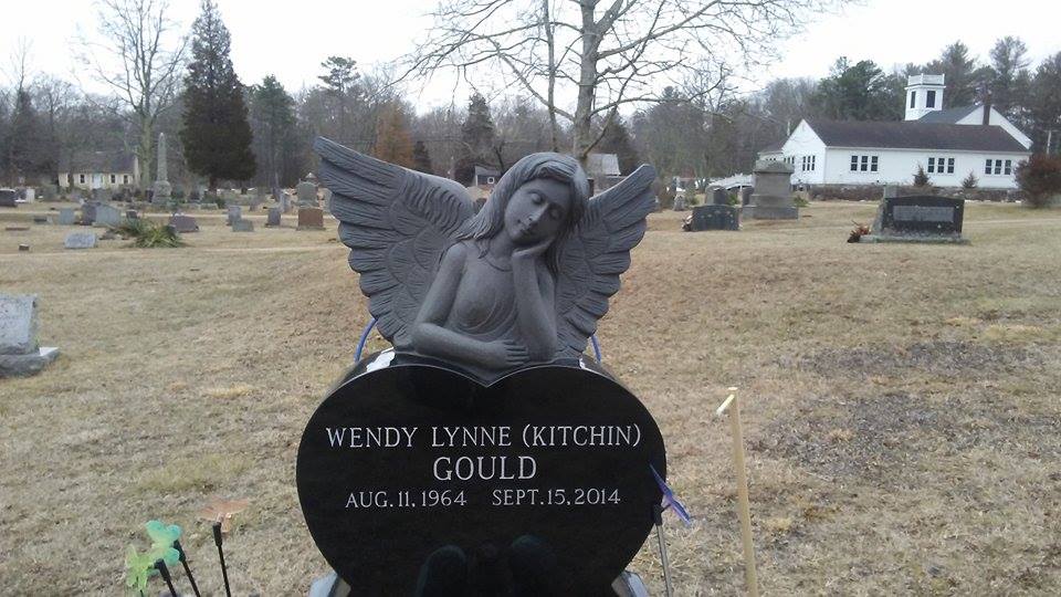
Mercy Brown, pictured below, is the most famous of the 80 recorded cases where a vampire-themed exhumation went on.


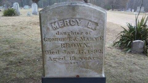
Mercy was one of an unfortunate group of children that George and Mary Brown bore. George was a farmer living a hard life working a rocky Rhodey homestead. The consumption came for his family, taking Ma Brown in 1893 and a daughter the next year. The mother and daughter were Mary and Mary Olive. There was also a sister named Mercy Lena.

Mercy fell sick and died in 1892. Then her brother Edwin fell sick. This set off a superstition algorithm involving multiple consumption deaths in the same family equaling undead predation.

That was enough for the villagers. Perhaps fearing that Mercy would move on to their own families after polishing off the Brown blood bank, several locals- after a vote- approached George with a folk remedy. It may have been the last conversation of the Dark Ages.

Although he gave his permission, George was not in attendance when a Frankenstein-style mob moved on the crypt that held the remains of Mercy Brown. Distinct among the group, which was most likely smaller than a mob, were a wildly protesting doctor and a Providence Journal reporter.

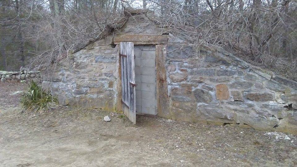
Mercy was a winter death, and she was stored in the above-ground crypt that we have a picture of somewhere in this article. She was kept this way until the ground thawed enough for a burial. You should note that her crypt was very much similar to how they stored ice back then.

They checked the coffins of all the Brown women. Two of them were Corpsing along as they should have been. Mercy was a whole other story.

Mercy didn't look that bad for a corpse. The cold had preserved her well. They cracked open her chest and cut out her heart. It still had blood in it. Bingo! We got us a vampire!

Since this was 5 years before Dracula was written (Bram Stoker had an article about the Brown exhumation among his papers, and may have based Lucy Westerna on Mercy Brown), the people- who only acted like Serbians, and didn't actually use Serbian words like vampyr- probably just called her Mercy or Lena... especially around George, who most likely had to be handled diplomatically.

Vampire slaying methodology varied from region to region. Both Plymouth and Maine, connected by maritime trade, favored burying the corpse face down. Vermont was more brutal, and their methods spread down the Connecticut River into eastern Connecticut and western Rhode Island.

Mercy's heart was placed on a nearby stone and cooked to a cinder. The ashes were then fed to her ailing brother, most likely in a tea. It worked so well, he was dead in two months, and is buried next to the sister that he consumed.

Opinions vary as to whether it was effective. The doctor pointed out that Mercy's lungs showed tuberculosis. He no doubt spoke up when the remedy failed to cure Edwin. The locals pointed out that no Browns got sick after Edwin.

Michael Bell, the authority on such matters, says that exhumations occurred in America until the mid 20th Century. The last one Bell is aware of went down in the Pennsylvania mountains in 1949. A construction crew in Griswold, CT dug up an ancient cemetery in 1990. One of the graves had been broken into. The corpse was beheaded, the heart was torn out and the legs were broken off. The damage was done 5 years after death.

Mercy wasn't the last one, but is the most famous one. Her desecration got national publicity, all negative, and western Rhode Islanders were known as superstitious and "vicious" by neighboring communities, with the Boston Globe suggesting inbreeding as a cause for the vampire panic.

We checked out her grave recently, as one of our road trips took us into that Rhodey/CT midst. Route 95 goes through there now, and Exeter is a charming bedroom suburb of Providence. You can still see the Old Days if you poke around some.


Friday, March 31, 2017

Late Season Snow Information


Late-season snow facts:

- According to WBZ, Boston has had snowfall of 12 inches or more after March 20th once, in 1997. More on that in a sec.  Boston has 6 instances where 6 or more inches of snow fell after March 20th. Worcester has had 12 such events.

- Spring starts at 12:30 AM this Sunday, March 20th.

- The average date of Boston's last snowfall is March 25th.

- The latest measurable snowfall for Boston was a half inch on May 10th, 1977. The latest we've had non-accumulating snow in Boston was June 10th, 1955.

- This source tells me that New York and Atlanta both have the same day, in different years, for latest snowfall... April 25th.

- Most of New England had frost on August 23rd in 1816, and lake ice was seen around the Bay State into August.. This was due to the eruption of Mount Tambora in Indonesia, which gave everyone red, smoky skies and drove worldwide temperatures down. New England had her corn crop fail, and all sorts of food prices skyrocketed. June snow fell in some parts of New England. It is known as The Year Without A Summer. They had one period where it went from 95 degrees to 35 degrees in a half day.

- Three late-season snowstorms stand out in our history. One was that May 10th, 1977 one from The Farmer's Almanac. The record is a bit later in the year for the Berkshires. The other late-season trace snow events of note in our history are the ones I was yapping about up above.

- Our second storm of note was the 1997 April Fool's Day Blizzard. Over 25 inches of snow fell on Boston, and coastal flooding tore apart the shoreline.

- Our third late-season storm of note was a 17-21 inch blockbuster that hit Worcester and areas north on April 28th, 1987.

I was a freshman at Worcester State College for that storm, and had just picked up a girl from West Boylston High School for a date... because that's how I rolled in 1987, playboy! We went to a movie, came out, and there were 6 inches of snow on the ground. We had an Italian dinner somewhere, and there was a foot on the ground when we came out of the restaurant.

I had only been driving for a year, and had zero savvy. We nearly hit a plow when we skidded all the way down a hill on Route 9. We also drove into a drift in some guy's yard in Berlin, Massachusetts. It ended well... the homeowner called his sons out to shove my car from the drift, and they came out single file... and each one was bigger than the last. "Don't worry about it, just steer" is how the father replied when I offered to make Katie drive so that I could get out and help shove the car. They literally lifted my car and threw it from the drift.

I got zero (0) play from that date, too. The only time I even got a hug as when we nearly crashed into the plow, and that may have been a case where she was trying to wrestle me into a position where the plow blade hit me first. I really can't blame her.

Anyhow, 17 inches of snow is about as much as we get that late in the year. If you get snow on your lawn after May 10th, you just saw a regional record.


Our own March Madness brackets for Worst Massachusetts Storm Ever

1) 1938 Great New England Hurricane

2) 1635 Great Colonial Hurricane

3) Blizzard of '78

4) Hurricane Bob, 1991

5) Worcester Tornado, 1953

6) Halloween Gale, 1991

7) Blizzard of 1888

8) 1898 Portland Gale

9) April Fool's Blizzard, 1997

10) Hurricane Carol/Edna, 1954

11)  Hurricane Donna, 1960

12) The Great September Gale Of 1815

13)  Winter of 2015

14) 1944 Great Atlantic Hurricane

15) The Triple Storms of 1839

16) Blizzard of 2005


Lower Seeds:

2008 Ice Storm

1698, reported 42 inches of snow in Cambridge

1831 Snowstorm, 3 feet on the Cape

1978 pre-Blizzard January snowstorm

2011 Springfield Tornado

Blizzard of 2013

1993 Superstorm

Saxby Gale, 1869

1969 100 Hour Storm

Winter of 1717

1996 South Shore microburst

Hurricane Belle

Hurricane Gloria

Hurricane Irene

Hurricane Sandy/Post-Sandy Wareham microburst

1960 snowstorm


Sunday, March 19, 2017

Should Route 3A Have A Nickname?


Granted, there are more important issues on the table. Syria and Iraq look messy. The Trumpcare rollout has been slightly less than smooth. North Korea is advancing their nuclear technology. There are many problems in the world more important than naming Route 3A something cool.

However, those problems require complex solutions, ones that will most likely not be figured out by a wandering stoner journalist lining up his next road trip. However, I'm just the man to bring this issue to your attention and maybe float a few names out there to sort of jump-start the process. I'm not smart enough for a brainstorm, but I do generate an impressive squall line now and then. That's good enough to name a highway.

One thing that Bourne, Wareham and Sandwich do well is name highways. Sandwich has the Old King's Highway (Route 6A), Bourne has the Scenic Highway (mainland Route 6, between the bridges) and ?ham has the Cranberry Highway. You could also throw in the Mid-Cape Highway and the Grand Old Army of The Republic Highway, but we're getting ahead of ourselves.

Running a road along the Canal and giving it a catchy name didn't get the Muslims and the Jews to stop bickering or anything, but it adds some character to the area, makes it easier for traffic reports and helps the tourists along.

Meanwhile, the 50 mile stretch of road between Bourne and Quincy- Route 3A- has no nickname at all. Wikipedia says it is known as the "Cape Way" highway, but that sort of doesn't really work either functionally (these days), as no one goes to the Cape that way anymore, and stylistically (ever). "Cape Way" blows like the mighty north wind.

Every year at around St. Patrick's Day time, we run whatever Irish-themed articles we have kicking in the archives. "Check Your Irish" is a good one, as is "The Irish Riviera."

One thing you'll learn if you read either article (or read both, I need the money) is that the area between Quincy and Bourne is stuffed with Irish-Americans. That, and the seasonal/coastal nature of the area, garnered the "Irish Riviera" nickname for the area.

Many inland towns have high Irish populations, but the big unbroken run of 33+% Irish goes from Weymouth to Plymouth.

If you stare at a map long enough, you'll also notice that Route 3A runs right through the same area. While 3A itself is inland some and doesn't host the actual Riviera, it connects to every piece of it through a sort of river/tributary system.

If you weigh the factors of 1) no effective Route 3A nickname and 2) the green wave of Irish-Americans in that Plymouth-Weymouth stretch, a solution comes to mind. Give it an Irish-themed nickname.

There are many sorts of nicknames, some official, some not. At least one pol who I asked said I'd have to go to MassDOT. That's if we want to go official. If we just want to introduce a nickname or three into the public domain and see if one of them catches on, all we have to do is write an article and post it a bit.


Let's kick a few around, shall we?

- "St. Patrick's Highway" has a nice ring to it, but it may violate the concept of keeping the church and state apart. That's probably my only official-sounding one.

- "Paddy Road" sounds like an Irish Mob movie, but it is also very catchy.

- "Mick Street" and the Happy Meal-sounding "McStreet" might offend someone, but it won't be someone Irish. The Irish, who were compared with dogs for a lot of US history, are incapable of taking offense. Don't believe me? Approach any college and say "You should be more like the Notre Dame Fighting Irish. How about the Bridgewater State University Crafty Jews?" You're not going to get a callback, player. Meanwhile, Irish-Americans who have never been near Indiana root for Notre Dame. If you think Christianity has anything to do with that, suggest that the bartender at your local sports bar stop what he is doing and hunt through the channels for the Oral Roberts University game.

- I am reluctant to put quote marks around O'Boulevard, because it already has a half of one in it.

- "The Green Mile" has ominous connotations from the movie that will be gone in a generation or two. It will also fit perfectly into those "Massachusetts Roads Make No Sense" memes, along the lines of "The Green Mile is 50 miles long." This nickname also lets us experiment with painting those yellow lines in the road green, which is just the thing to do in resort areas with a hard-drinking population base.

- "Shamrock Lane" sounds like a stripper, but it is also very catchy and relatively inoffensive to people who aren't a bit too familiar with Stripper Naming. The movie with the giant monster (Cloverfield or John Goodman, take your pick) sort of ruined any "Clover Road" possibilities.

- "The Guinness Bypass" would be ugly the first time someone de-barked a Route 3A tree.

- "The Capital Highway" would be a simple power grab. Ireland stopped being the place with the most Irish one potato famine ago. America now has the most people of Irish descent, by a large margin. In America, Massachusetts is known as the most Irish state.  In Massachusetts, the South Shore is recognized as the most Irish part of the most Irish state. Why shouldn't the South Shore thus have Capital status? Ireland can put the Capitol wherever they wish, but we can make a great claim to the Capital status. We should make a reality of that claim by naming Route 3A in such a mindset.

- "The Leprebahn" is a mishmash spelling of the little Irish pixie and the Autobahn in Germany where you can drive 200 mph if your car (and skills) will support it. We could paint the stripes between the lanes Gold, like the pot o' gold that the leprechaun guards. To save money, we can just declare that we painted them gold, leave them as the present yellow that they are, and hope that it either A) fools the tourists or B) amuses the locals. Stacey, an editor here, is arguing strenuously for a spelling of "Leprechahn."

- "The Edge" is not only a cool name for a road, but it is U2 related. U2 is an Irish rock band that the kids are listening to these days, or 1986 or whatever. That in itself doesn't merit a road, but could the actual real Edge guy be persuaded to record a quick ditty in exchange for having a highway named after him? I float this possibility only because Route 3A doesn't have her own song, like Route 128 does with that Roadrunner song by the Modern Lovers... although someone once told me that Roadrunner somehow references Cohasset (Editor's Note: Christine Frka, a former Frank Zappa groupie, lived and died at the Cohasset house of Modern Lovers founder Johnathan Richman,,, h/t to Nathaniel Palmer) . The Edge could hand us that title with ten minutes work.

- "Beating A Dead Horse Street" comes to mind when it's time to end this article.


Tuesday, March 14, 2017

Blizzard Inland, Winter Storm For SE Mass, Coastal Flooding, Power Outages


...WINTER STORM WARNING REMAINS IN EFFECT UNTIL 3 PM EDT THIS
AFTERNOON...

Western Plymouth MA-Eastern Plymouth MA-Southern Bristol MA-
Southern Plymouth MA-Western Kent RI-Eastern Kent RI-Bristol RI-
Washington RI-Newport RI-
Including the cities of Brockton, Plymouth, Fall River,
New Bedford, Mattapoisett, Coventry, West Greenwich,
East Greenwich, Warwick, West Warwick, Bristol, Narragansett,
Westerly, and Newport
719 AM EDT Tue Mar 14 2017

* LOCATIONS...Southeast coastal Massachusetts and Coastal Rhode
Island.

* HAZARD TYPES...Heavy wet snow and strong winds.

* ACCUMULATIONS...Snow accumulation of 4 to 8 inches.


* TIMING...Snow develops through 7 am and becomes heavy by mid
morning. Snowfall rates of 2 to 4 inch per hour snowfall rates
possible through early afternoon before precipitation changes
to sleet and then rain.

* IMPACTS...The heavy wet snow and strong winds may result in
tree damage and scattered power outages along with poor
visibility. Roads may become impassable at times from the
heavy wet snow combined with the strong winds.

* WINDS...Northeast 20 to 30 mph with gusts up to 65 mph.

* VISIBILITIES...One quarter mile or less at times.

PRECAUTIONARY/PREPAREDNESS ACTIONS...

A Winter Storm Warning means significant amounts of snow are
expected. This will make travel very hazardous or impossible.


...COASTAL FLOOD WARNING NOW IN EFFECT FROM 11 AM THIS MORNING TO 4 PM EDT THIS
AFTERNOON...

...COASTAL FLOOD WATCH IS CANCELLED FOR TONIGHT/S HIGH TIDE...

* LOCATION...NORTH AND EAST FACING SHORELINES OF CAPE ANN INCLUDING PLUM
ISLAND.

* TIDAL DEPARTURE...A 2 TO 3 FOOT STORM SURGE IS LIKELY DURING THE EARLY
AFTERNOON HIGH TIDE CYCLE TODAY.

* TIMING...WITHIN A FEW HOURS ON EITHER SIDE OF THE EARLY AFTERNOON HIGH TIDE
CYCLE TODAY.

* COASTAL FLOOD IMPACTS...WIDESPREAD MINOR WITH AREAS OF MODERATE COASTAL
FLOODING ARE LIKELY. MODERATE TO SEVERE EROSION IS LIKELY FROM THE WAVE
ACTION ALONG OCEAN EXPOSED SHORELINES OF PLUM ISLAND.

* SHORELINE IMPACTS...MODERATE TO SEVERE EROSION IS POSSIBLE FROM WAVE ACTION
ALONG OCEAN EXPOSED SHORELINES.

PRECAUTIONARY/PREPAREDNESS ACTIONS...

A COASTAL FLOOD WARNING IS ISSUED WHEN MODERATE OR MAJOR COASTAL FLOODING IS
EXPECTED. MODERATE COASTAL FLOODING PRODUCES WIDESPREAD FLOODING OF VULNERABLE
SHORE ROADS AND/OR BASEMENTS DUE TO THE HEIGHT OF THE STORM TIDE AND/OR WAVE
ACTION. NUMEROUS ROAD CLOSURES ARE NEEDED. LIVES MAY BE AT RISK FOR PEOPLE WHO
PUT THEMSELVES IN HARMS WAY. ISOLATED STRUCTURAL DAMAGE MAY BE POSSIBLE.

MAJOR COASTAL FLOODING IS CONSIDERED SEVERE ENOUGH TO CAUSE AT LEAST SCATTERED
STRUCTURAL DAMAGE ALONG WITH WIDESPREAD FLOODING OF VULNERABLE SHORE ROADS
AND/OR BASEMENTS. SOME VULNERABLE HOMES WILL BE SEVERELY DAMAGED OR DESTROYED.
NUMEROUS ROADS ARE IMPASSABLE...SOME WITH WASHOUTS SEVERE ENOUGH TO BE LIFE-
THREATENING IF ONE ATTEMPTED TO CROSS ON FOOT OR BY VEHICLE. SOME NEIGHBORHOODS
WILL BE ISOLATED. EVACUATION OF SOME NEIGHBORHOODS MAY BE NECESSARY.


TIME OF HIGH TOTAL TIDES ARE APPROXIMATE TO THE NEAREST HOUR.

SCITUATE

TOTAL
TIDE DAY/TIME SURGE WAVES FLOOD
/FT/ /FT/ /FT/ CATEGORY
----------- ---------- --------- ------- ----------
7.8- 8.3 14/03 AM -0.2/ 0.3 1 NONE
12.6-13.1 14/02 PM 2.8/ 3.4 7-16 MODERATE
11.4-11.9 15/02 AM 1.8/ 2.2 7-11 MINOR
9.2- 9.7 15/02 PM -0.2/ 0.2 5 NONE
9.3- 9.8 16/02 AM -0.2/ 0.3 5 NONE
8.8- 9.3 16/03 PM -0.2/ 0.2 2 NONE

VINEYARD HAVEN

TOTAL
TIDE DAY/TIME SURGE WAVES FLOOD
/FT/ /FT/ /FT/ CATEGORY
----------- ---------- --------- ------- ----------
1.4- 1.9 14/03 AM 0.0/ 0.5 1 NONE
5.4- 5.9 14/02 PM 3.7/ 4.2 3-6 MODERATE
1.9- 2.3 15/02 AM 0.1/ 0.6 3 NONE
1.4- 1.9 15/03 PM -0.2/ 0.2 2-3 NONE
1.2- 1.7 16/03 AM -0.6/-0.1 3 NONE
0.7- 1.1 16/04 PM -0.8/-0.2 2 NONE

NANTUCKET HARBOR

TOTAL
TIDE DAY/TIME SURGE WAVES FLOOD
/FT/ /FT/ /FT/ CATEGORY
----------- ---------- --------- ------- ----------
2.7- 3.2 14/03 AM -0.2/ 0.3 1 NONE
5.4- 5.9 14/03 PM 2.3/ 2.8 5-7 MINOR-MDT
5.1- 5.6 15/03 AM 2.0/ 2.5 5 MINOR
2.7- 3.2 15/03 PM -0.2/ 0.2 4 NONE
2.7- 3.2 16/04 AM -0.3/ 0.2 5 NONE
2.2- 2.7 16/04 PM -0.6/-0.1 3 NONE

SANDWICH / DENNIS

TOTAL
TIDE DAY/TIME SURGE WAVES FLOOD
/FT/ /FT/ /FT/ CATEGORY
----------- ---------- --------- ------- ----------
12.8-13.3 14/01 PM 2.8/ 3.4 4-9 MINOR-MDT
12.7-13.2 15/02 AM 2.7/ 3.2 4-5 MINOR
9.4- 9.9 15/02 PM -0.2/ 0.2 2-3 NONE
9.7-10.2 16/02 AM 0.1/ 0.6 3 NONE
9.0- 9.5 16/03 PM -0.2/ 0.2 2 NONE

PROVINCETOWN HARBOR

TOTAL
TIDE DAY/TIME SURGE WAVES FLOOD
/FT/ /FT/ /FT/ CATEGORY
----------- ---------- --------- ------- ----------
8.6- 9.1 14/03 AM 0.0/ 0.5 1 NONE
12.4-12.9 14/02 PM 2.0/ 2.5 6 MINOR
11.1-11.6 15/02 AM 0.7/ 1.1 5 NONE
9.9-10.4 15/02 PM -0.2/ 0.2 2-4 NONE
10.1-10.6 16/03 AM -0.2/ 0.3 3 NONE
9.3- 9.8 16/03 PM -0.5/ 0.0 3 NONE

CHATHAM - EAST COAST

TOTAL
TIDE DAY/TIME SURGE WAVES FLOOD
/FT/ /FT/ /FT/ CATEGORY
----------- ---------- --------- ------- ----------
5.2- 5.7 14/03 AM 0.0/ 0.5 2 NONE
8.9- 9.4 14/02 PM 3.2/ 3.7 9-20 MINOR
7.5- 8.0 15/03 AM 1.9/ 2.3 9-12 NONE
5.2- 5.7 15/03 PM -0.2/ 0.2 6-7 NONE
5.4- 5.9 16/03 AM -0.2/ 0.3 6 NONE
4.7- 5.2 16/04 PM -0.5/ 0.0 3 NONE


Sunday, March 12, 2017

B Word! Blizzard Watch For The South Shore, South Coast


UPDATE: Blizzard Watch now covers all of Plymouth and Bristol Counties!

*************************************
BLIZZARD WATCH REMAINS IN EFFECT FROM LATE MONDAY NIGHT
THROUGH LATE TUESDAY NIGHT...

* LOCATIONS...Southern Rhode Island and east coastal
Massachusetts from Boston to Plymouth.

* HAZARD TYPES...Heavy snow, strong winds, and reduced
visibility.

* ACCUMULATIONS...Snow accumulation of greater than 6 inches
possible along drifting and blowing snow.

* TIMING...Tuesday and Tuesday night.

* IMPACTS...Rapid snow accumulation as well as blowing and
drifting snow may make many roads impassable. There could also
be scattered power outages.

* WINDS...Northeast 25 to 35 mph with gusts over 50 mph.

* TEMPERATURES...In the lower 30s Tuesday.

* VISIBILITIES...One quarter mile or less at times.

PRECAUTIONARY/PREPAREDNESS ACTIONS...

A Blizzard Watch means there is a potential for considerable
falling and/or blowing snow with sustained winds or frequent
gusts over 35 mph, with visibilities below one quarter mile, for
at least 3 hours. Whiteout conditions will be possible, making
travel very dangerous. Be prepared to alter any travel plans.


Please note that Cape Cod and the interior of both Plymouth and Bristol County aren't in the Blizzard mix... yet.

The rest of Southern New England has a Winter Storm Watch.

Also note that the areas with the Blizzard Watch are the areas with (as for now) the lowest forecast snow totals.

Remember, a Blizzard isn't just heavy snow, it involves winds and visibility. As we've pointed out before, you can have a Blizzard with no snow falling at all, but that's an extreme case where you need an iced-over Lake Superior full of dry, fluffy snow and a high wind.

Coastal Flooding will be major and ridiculous. They are forecasting a 2-3 foot storm surge, on what I believe is a 9.9 and then a 10.0 tide on Duxbury Beach on Tuesday morning and Tuesday night. Only an unexpected wind shift will save the South Shore from a major Poseidonistic curb-stomping.

We'll try to embed ourselves somewhere dangerous for the high tides, but no promises. The Cranberry County Magazine Cranmobile barely made it over the Bourne Bridge in the last blizzard, and the house that I usually storm-watch from on Duxbury Beach is rented. We'll do our level best for you, however.


Snow Total Predictions From Local News Stations:

WBZ... " Plan on around a foot of snow for most (give or take a few inches) and maybe two feet.".... don't EVER bitch at me about a vague forecast again, Pam Gardener is getting 6 figures.

WHDH... " I think it’s a lock to say we see a widespread 6″ of snow…  I think it’s a VERY good possibility we see a widespread 10-16″ of snow.  I think it’s also a possibility that we get...closer to 20″ of snow.".... There's your "six to twenty inches" forecast that you see Boston weather girls drop now and then. Brie Eggers may just be in a More Vague contest with Pam Gardener.

WCVB... 12-18" for Emass, 5-10" with some rain for Cape Cod

WFXT... 1-3" with rain on the Cape , 3-6" Plymouth/Bourne/South Coast, 6-8" interior Plymouth/Bristol Counties, 8-12" central/western MA

NECN... 5-15" coast, 10-20" inland

Accuweather... 9.7" in Buzzards Bay by Wednesday AM


Info you may need or want:

Tide Charts

Eversource Outage Map

National Weather Service

Forecast Flood Maps (for hurricanes, but still a useful tool.... maps for all towns in EMass)

NWS Boston Facebook

Nor'easter Blues storm information/reporting Facebook page