Showing posts with label coastal flooding. Show all posts

Monday, November 14, 2016

Supermoon King Tide Brings Coastal Flooding Concerns


by Tristan Umeda, owner of Family Pet & Supply.

We are witnessing a unique lunar event, as the moon is getting as close to us as it has been since the 1940s. You no doubt saw her in the sky last night, and perhaps will see it tonight. They call it a Perigree Moon, and it is the opposite of an Apogee (furthest distance) Moon.

The original inhabitants of the area called it a Beaver Moon, and the weather man calls it a Supermoon. We're in a run of them, having had one in October, and awaiting the one in December. This, however, is what Fred G. Sanford would call "the Big One."

The moon exerts influence on many things. Aboriginals, as we saw, use the moons to know when to check the beaver traps for fur. Werewolves and Witches favor the full moon. Smugglers hate the full moon, with the Outer Cape term "mooncusser" stemming from this professional dislike.

Coastal Residents also are wary of Supermoons. Supermoons produce King Tides, also known locally as Flood Tides.  Flood Tides are the kind of tides where the road or the basement flood without the usual nor'easter storm catalyst.

Well, at least we won't have a storm to worry about, right? Wait... what?

A storm will move up the East Coast at us Tuesday, and this will get that Supermoon/King Tide amped up even more. This won't be a crusher of a storm, with winds more along the 15-30 MPH range than the 35-74 MPH range. Those winds will be sufficient to work up some surf, and the wves will arrive at the worst possible astrological time or astronomical time or whichever one doesn't mean your horoscope.

This isn't a storm that will tear your house down and beat you with it, but it may flood the road or give you a brand new indoor basement pool.

Brant Rock is looking at a 12 foot high tide at 11:13 AM Tuesday. zthe Sandwich end of the Cape Cod Canal gets an 11.3 foot high tide. Scituate gets an 11.8 foot high tide. Barnstable Harbor gets a 12.5 foot tide. Plymouth Harbor gets a 12.8 foot tide. Duxbury Harbor gets a 13 foot tide. Check your high tide here.

We'll be at Duxbury Beach tomorrow to see what's what. We were at Plymouth for high tide today, as you see below. We'll be back with an update tomorrow.


I stole Tristan's pic because this is what my skillz do to a Supermoon, below:


Friday, October 21, 2016

King Tide At Duxbury Beach


We headed out to Duxbury Beach to check out the King Tide. A king tide is when the moon, sun and Earth align. It increases gravitational pull on the ocean, and produces some of the higher tides of the year. We hit town as the king tide was receding... it was only 11.8 feet today, down from 12.8 Wednesday. It'll be down to 10.1 soon.
A tide two feet above normal would be trouble if it went down as a storm hit, which is why October is the start of Nor'easter season. However, Duxbury was No Problemo today. They probably had some spray come over the wall and they did have a Coastal Flood Advisory, but no damage was done today.

Wave good-bye to the King Tide.


Thursday, September 22, 2016

Dealing With The Ocean On Duxbury Beach


Living on the coast is pretty much the peak human condition. You can walk around barefoot. The beach is within hollering distance. You have a zillion trillion gallon outdoor pool. If you can convince a girl to visit you, she's a good bet to show up wearing a bikini... something that I took for granted growing up on a beach, and something that I was slow to realize didn't happen everywhere when I went to school in Worcester.

Yup, life on the beach is pretty nice. There are costs, however. That gorgeous ocean can become stormy, and stormy seas can push ashore and inflict catastrophic damage on the houses there. While giant waves can smash houses to splinters, even little waves eat away bites of the shoreline in an endless war of attrition.

You can't beat the inexorable Mother Nature, but you can hold her off for a little while. In fact, if you either A) don't care if the house falls into the sea on the great-grandchildren's watch, long after you've gone to your reward, or B) have faith that the science people will solve the problem in the future, you really have to keep the sea at bay for only 20-75 years or so. After that... SEP.

We're going to tour a few beaches before the weather gets too bad and going to the beach becomes something akin to work. As we go to these beaches, we'll have a look at methods people use to fight Poseidon. 

There is no consensus on protecting beaches. You can see different methods on different beaches, something you'll notice as you read the articles we write about different beaches. You can also see different methods on the same beach, something you'll notice today as we start our series off in Duxbury.


Duxbury Beach has a mix of inhabited, uninhabited and semi-inhabited coastline.

You can see several methods of erosion control at work here. We have a dune, some snow fencing, some rocks, some beach grass, some scrub pine... we could use some beach plum bushes, but this will do.

Shoot, the whole of Duxbury Beach itself is an erosion control machine, as it serves as a barrier beach for Duxbury Proper across the bay.

The house that you can sort of see in the picture above is the last residence on Duxbury Beach. South of that, it's all sand dunes and snow fencing until you get to High Pines.


Beaches tend to get onshore winds, and those winds blow sand across the beach. Any sort of obstruction, be it a plant or a flower or a stone, slows down the wind and allows the sand and grass to accumulate. As the sea grass spreads, the sand is nourished, and other plants begin to appear. These plants block more and more sand. Over time, a dune forms.

If the ocean doesn't interfere, the dune grows and grows. However, that's a big If.

The snow fencing probably performs some erosion control purpose, but the main one I can think of is that it keeps people from walking on the fragile beach grass.

If you need to know how well it works, here's a picture of how the dunes looked when the Trans-Atlantic cable came ashore a little bit after the Civil War ended.... which is why everyone looks like General Sickles.


Duxbury-savvy folks will recognize that this is the area where Ocean Road North and Cable Hill meet. Prior to the cable coming ashore, this area was known as Rouse's Hummock.... after some guy named Rouse.

Most of the present beach south of the Blakeman's pavillion/bath house works along this model, but the dune in this picture is more impressive than anything seen on the beach today.

The dunes are lower because Duxbury Beach suffers from vicious nor'easters. Nor'easters seem to be elementally offended by dunes, because they wash over them regularly.

If that picture of the cable guys doesn't give you an idea how close to the water the dune is, worry you not! My house on Duxbury Beach was right about where the dude in the dark suit is standing off by himself on the top of the dune.


Here's a view from where he was standing 150 years later. There's a house there now, and a seawall in front of it, but those waves have been hitting the area like that once a year or so ever since time began.

There isn't much beach behind the dunes. Duxbury Beach is barely 100 meters wide at her fat points. The picture below is taken after a storm, and it is aimed at what is by far the fattest part of the beach. It turns to marsh just after the houses and trees.

Here is a picture out the back door (Duxbury Beach residents almost universally refer to the door facing the ocean as the front door, and the street-side door as the back door), showing how much slack the marsh is giving you. Much of Duxbury Beach becomes a series of small islands if the storm gets bad enough.

Post-storm, too...


Notice the shark fin in the water to the left of the telephone pole and above the hay bales? Ah, just kidding, that's not a shark.

That flood will take some time to go away, as the water table is maxed out and it's the lowest point in the neighborhood. The marsh will drain itself as the tide goes out, but the meadow is on her own.

They did lay some pipe under the road after this 2007 storm, and all but the final inches of water will flow back into the marsh through them.

Here are said pipes:


There are corresponding pipe holes on the other side of Gurnet Road. The pipes take care of the meadow and the marsh water. The waves are a whole other problem.

I went with the picture below because it was the best one I have that illustrates both the height of the seawall and the erosion of the sand.

The sand depth at the foot of the seawall varies greatly, and can be augmented by seaweed and rocks. It can make a great difference in wave damage.


The seawall/sand ratio is important, as the sand is what the seawall is based in. If there isn't enough sand supporting the wall, the wall can topple forward into the sea.

The seawall blocks waves for a gang o' houses that pay a pile o' taxes into the town coffers. Many are summer residences which pump no revenue-consuming brats into the town's school systems. Hence, the armored seawall.

Here's another blurry shot, showing how the Duxbury/Marshfield line has to use boulders to help shore up the wall. OK, "shore up" is probably the wrong term here.

I'd have gone closer to the boulders to try to get a shot that showed them better, but I wasn't trying to get wet.


The seawall is the central defense for the residential area of Duxbury Beach.

It's about 15 feet tall, with maybe half of it buried in sand. It's about two feet thick. It can withstand powerful surf without breaking, although they do break now and then.

It runs in two big lines, one extending from Green Harbor to the Duxbury line, and one from 100 yards past the other one down to the end of Ocean Road South.

The gap in the middle isn't a town vs town thing, as I thought it was until I talked to some old-timers. Now, I know that the gap in between the walls exists because the homeowners there, secure on a small bluff, declined to pay the $500 fee for the wall.

Their houses are still standing, so they currently are having the last laugh. Others are doing for self:


If you go there just after a storm, you get the virgin snowfall-looking sand cover.

It costs a pretty penny to put up your own seawall.

Q) Reason?

A) It's worth it.

This sort of DIY seawall, while very fine-looking, makes up about 1% of Duxbury's seawall shield.


Seawalls can only do so much. A powerful storm surge can make the ocean level with the seawall, and then the waves are rolling straight into the houses.

Some houses still have cellars, but they are a dying breed. You need sump pumps to get the ocean water out of them (I had a beach cellar, and the water came in through the windows, through the floor, and through the walls in the Blizzard of '78 and the 1991 Halloween Gale), and I neither have any pictures of sump pumps nor any desire to look for a Sump Pump video. You'll just have to take my word for it.

Any modern housing constructed on the shores need to be on pilings. This lets the water rush under the house rather than through it, which provides some comfort for the house and saves the lives of the homeowners.


This is a pretty good strategy, as I was trapped in my house on Duxbury Beach for the Perfect Storm in 1991, and I saw houses get torn apart by the surf. I also saw houses get lifted up by the surf and washed back into the road.

Stilt housing came into vogue shortly after that, and none of them have been knocked over yet. They have worked their way into the front line of housing along the coast.

There is some debate, mostly among people who were living on the beach for the peak storm activity of the Halloween Gale and the Blizzard of '78, as to whether the stilt housing will hold up against a 100 Year Storm.

Much like the Blizzard of '78 finished off the dune houses on Duxbury Beach, the next hurricane-force storm might finish off traditional-foundation style housing. Again, only time will tell.


Breakaway stairs are also useful.

They are made light enough to either

A) pull them up onto the wall by hand,

or

B) drag them back to your house with a Jeep if you got lazy or sloppy and forgot to do option A.

There is an option C, but that involves building the stairs out of mortar and cast iron. You don't have to pull these stairs up if a storm comes.


Pic by Sara Flynn

Be sure to check out our Plymouth version of this article.


Saturday, September 3, 2016

Tropical Storm Watch For Cape Cod, Islands, South Coast, (parts of) South Shore


The situation is going downhill quickly, as they say.

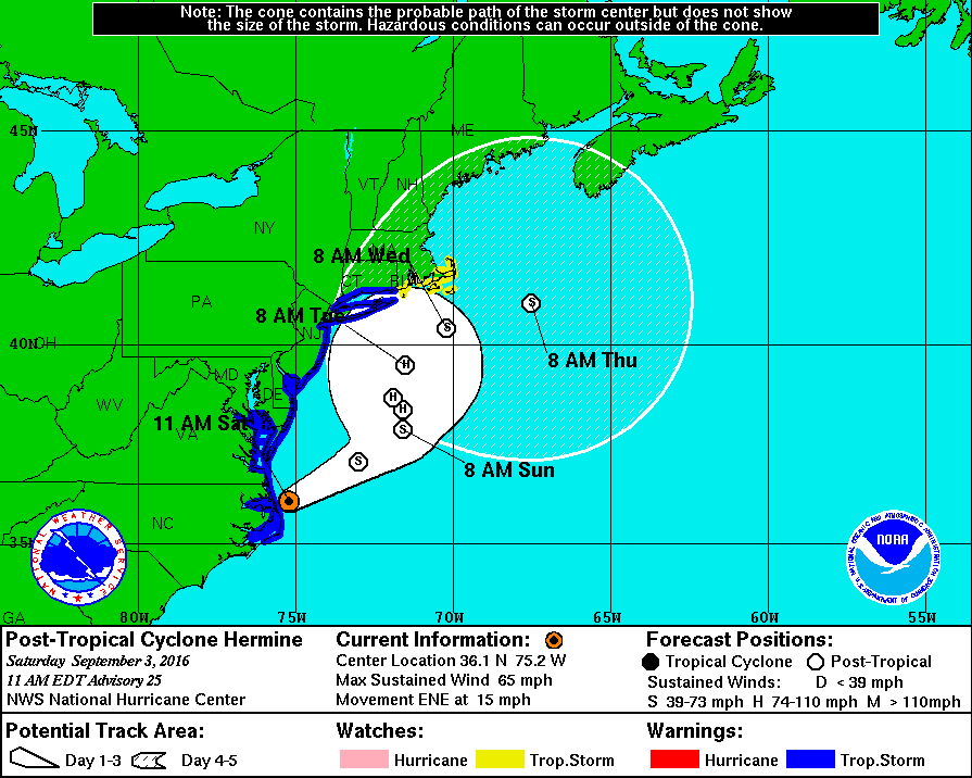
Tropical Storm Hermine emerged off of the Carolina coast as a strong tropical storm, and is forecast to regain hurricane status as it meanders around just south of us.

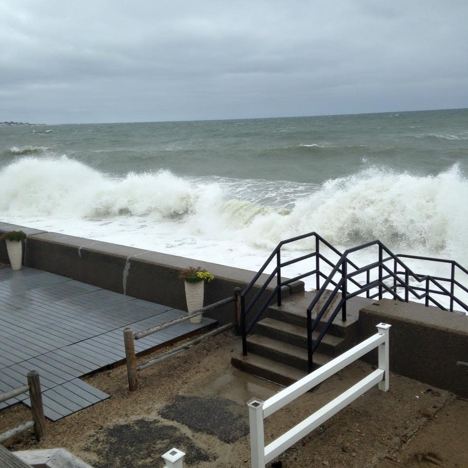
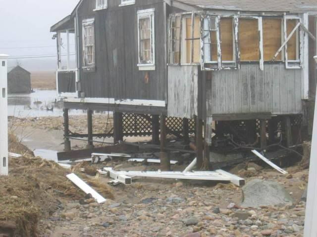
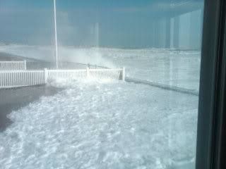
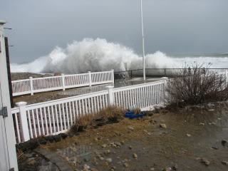
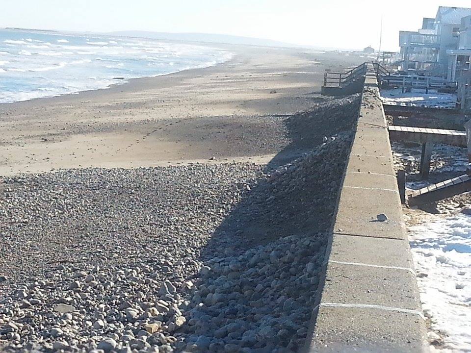
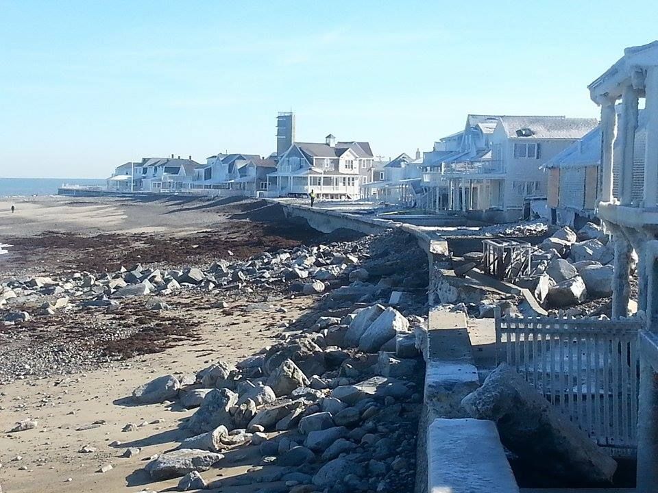
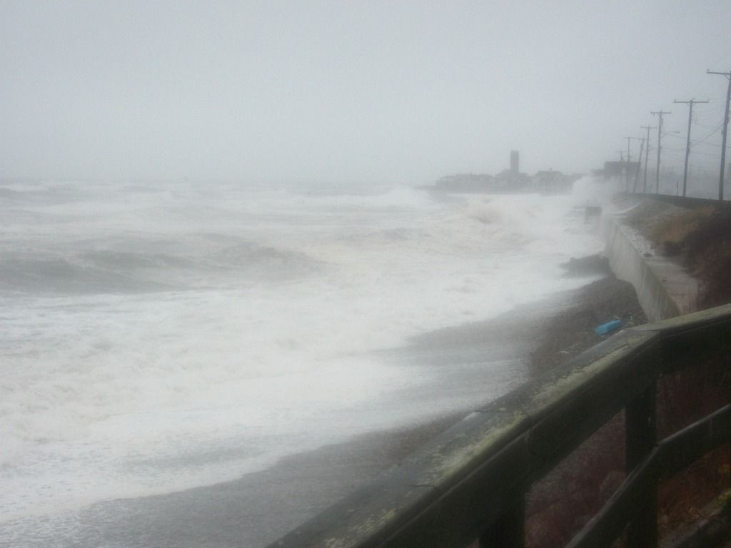
We could be in for several days of high surf and beach erosion. Like a nor'easter, this storm will aim 4-8 mean tides at Massachusetts beaches.

The National Weather Service has issued a Tropical Storm Watch (meaning that Tropical Storm conditions are possible within 48 hours) for all of the South Coast, both islands, Cape Cod and extreme Southern Plymouth County.

Plymouth, Kingston, Duxbury and points north are not currently under any watches or warnings from the NWS, but that could change with their 5 PM update.

We urge our readers to take whatever precautions are necessary, especially if you are on the coast. Seas will build for several days, and will have some fierce winds behind them.

It's looking like a Sunday night arrival, with a terrible Monday, a rotten Tuesday, and an improving but still coastal-floodish Wednesday and perhaps Thursday.

Two important things to keep in mind:

1) Hurricane Irene barely touched us, and some places had no power for 2 weeks.

and

2) A slight, and I mean slight westward jiggle of the track gives us a direct hit of a powerful tropical storm on Nantucket, and a slightly northern jiggle gives in a Barnstable/Chatham landfall.

Happy Labor Day! We'll be back with many updates.

Add caption
**TROPICAL STORM WATCH IS IN EFFECT FOR THE SOUTH COASTS OF RHODE
ISLAND AND MASSACHUSETTS INCLUDING THE ISLANDS**

NEW INFORMATION
---------------

* CHANGES TO WATCHES AND WARNINGS:
- A TROPICAL STORM WATCH HAS BEEN ISSUED FOR SOUTHERN BRISTOL
MA...SOUTHERN PLYMOUTH MA...BARNSTABLE MA...DUKES
MA...NANTUCKET MA...SOUTHEAST PROVIDENCE RI...EASTERN KENT
RI...BRISTOL RI...WASHINGTON RI...NEWPORT RI AND BLOCK ISLAND RI

* CURRENT WATCHES AND WARNINGS:
- A TROPICAL STORM WATCH IS IN EFFECT FOR SOUTHERN BRISTOL
MA...SOUTHERN PLYMOUTH MA...BARNSTABLE MA...DUKES
MA...NANTUCKET MA...SOUTHEAST PROVIDENCE RI...EASTERN KENT
RI...BRISTOL RI...WASHINGTON RI...NEWPORT RI AND BLOCK ISLAND RI

* STORM INFORMATION:
- ABOUT 450 MILES SOUTHWEST OF NANTUCKET MA
- 36.1N 75.2W
- STORM INTENSITY 65 MPH
- MOVEMENT EAST-NORTHEAST OR 60 DEGREES AT 15 MPH

SITUATION OVERVIEW
------------------

SITUATION OVERVIEW

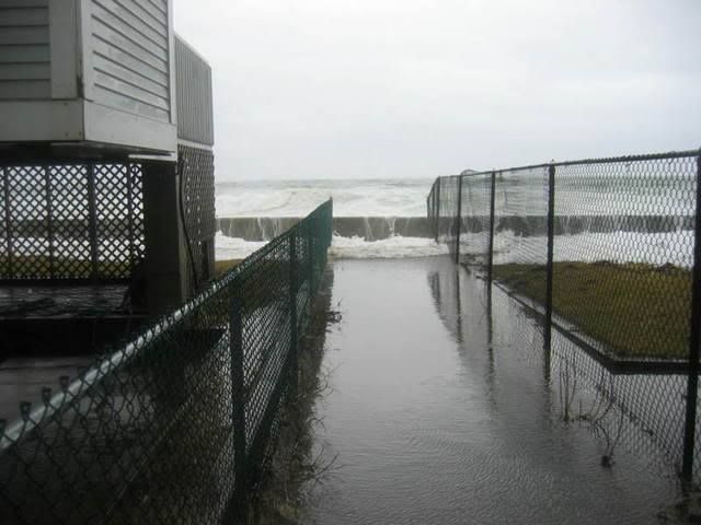
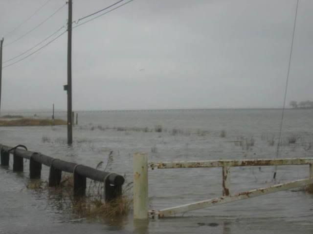
TROPICAL STORM HERMINE WILL AFFECT THE RHODE ISLAND AND MASSACHUSETTS
SOUTH COAST WITH WIND...ROUGH SURF...DANGEROUS RIP CURRENTS AND BEACH
EROSION. A TROPICAL STORM WATCH IS NOW IN EFFECT FOR THE SOUTH COASTS
OF RHODE ISLAND AND MASSACHUSETTS INCLUDING BLOCK ISLAND...MARTHA/S
VINEYARD...NANTUCKET AND CAPE COD. TROPICAL STORM FORCE CONDITIONS ARE
MOST LIKELY FROM LATE SUNDAY THROUGH MONDAY MORNING. SINCE HERMINE IS
EXPECTED TO STALL SOUTH OF NEW ENGLAND...SQUALLS WITH TROPICAL STORM
FORCE GUSTS MAY AFFECT THE RHODE ISLAND AND MASSACHUSETTS SOUTH COAST
THROUGH MID WEEK.

TROPICAL STORM FORCE WINDS MAY ARRIVE ACROSS BLOCK ISLAND...MARTHA/S
VINEYARD AND NANTUCKET BY SUNDAY AFTERNOON AND SPREAD ALONG THE THE
SOUTH COAST FROM WESTERLY RHODE ISLAND TO CHATHAM MASSACHUSETTS
SOMETIME SUNDAY EVENING. WIND GUSTS BETWEEN 40 AND 50 MPH ALONG THE
IMMEDIATE SOUTH COAST AND ISLANDS MAY DOWN SOME TREES AND LARGE
BRANCHES WITH SCATTERED POWER OUTAGE. SOME TREES MAY BE MORE
SUSCEPTIBLE TO WIND DAMAGE DUE TO STRESS FROM DROUGHT CONDITIONS.

ALONG THE SHORE...DANGEROUSLY ROUGH SURF AND LIFE THREATENING RIP
CURRENTS ARE LIKELY SUNDAY INTO THE MIDDLE PART OF NEXT WEEK...
ESPECIALLY ALONG RHODE ISLAND AND MASSACHUSETTS SOUTH COAST BEACHES. A
STORM SURGE OF 2 TO 3 FEET MAY OCCUR DURING THE SUNDAY NIGHT AND
MONDAY HIGH TIDES ALONG THE RHODE ISLAND COAST FROM WESTERLY TO POINT
JUDITH. A 1 TO 2 FOOT STORM SURGE IS LIKELY ALONG THE REST OF THE
RHODE ISLAND AND MASSACHUSETTS SHORELINES. HIGH SURF ON TOP OF THE
ELEVATED WATER LEVELS MAY CAUSE MINOR TO MODERATE BEACH EROSION ALONG
THE RHODE ISLAND COAST BETWEEN WESTERLY AND POINT JUDITH INCLUDING THE
MISQUAMICUT BEACH AND CHARLESTOWN AREAS. MINOR BEACH EROSION IS
POSSIBLE ALONG THE REST OF THE OCEAN EXPOSED RHODE ISLAND AND
MASSACHUSETTS SHORELINES.

A FEW HEAVY DOWNPOURS ARE POSSIBLE SUNDAY NIGHT INTO EARLY NEXT WEEK
ACROSS RHODE ISLAND AND SOUTHEAST MASSACHUSETTS...BUT FLOODING OF
STREAMS AND RIVERS APPEARS UNLIKELY AT THIS TIME.

POTENTIAL IMPACTS
-----------------

* WIND: PREPARE FOR DANGEROUS WIND HAVING POSSIBLE SIGNIFICANT
IMPACTS ACROSS THE SOUTH COAST. POTENTIAL IMPACTS IN THIS AREA
INCLUDE:

- SOME DAMAGE TO ROOFING AND SIDING MATERIALS, ALONG
WITH DAMAGE TO PORCHES, AWNINGS, CARPORTS, AND SHEDS. A FEW
BUILDINGS EXPERIENCING WINDOW, DOOR, AND GARAGE DOOR FAILURES.
MOBILE HOMES DAMAGED, ESPECIALLY IF UNANCHORED. UNSECURED
LIGHTWEIGHT OBJECTS BECOME DANGEROUS PROJECTILES.

- SEVERAL LARGE TREES SNAPPED OR UPROOTED, BUT WITH GREATER
NUMBERS IN PLACES WHERE TREES ARE SHALLOW ROOTED. SEVERAL FENCES
AND ROADWAY SIGNS BLOWN OVER.

- SOME ROADS IMPASSABLE FROM LARGE DEBRIS, AND MORE WITHIN URBAN
OR HEAVILY WOODED PLACES. A FEW BRIDGES, CAUSEWAYS, AND ACCESS
ROUTES IMPASSABLE.

- SCATTERED POWER AND COMMUNICATIONS OUTAGES,
BUT MORE PREVALENT IN AREAS WITH ABOVE GROUND LINES.

* FLOODING RAIN:
LITTLE TO NO IMPACTS ARE ANTICIPATED AT THIS TIME ACROSS
SOUTHERN NEW ENGLAND.

* TORNADOES:
LITTLE TO NO IMPACTS ARE ANTICIPATED AT THIS TIME
ACROSS SOUTHERN NEW ENGLAND.

PRECAUTIONARY/PREPAREDNESS ACTIONS
----------------------------------

* EVACUATIONS:

IF YOU ARE EXCEPTIONALLY VULNERABLE TO WIND OR WATER HAZARDS FROM
TROPICAL SYSTEMS, CONSIDER VOLUNTARY EVACUATION, ESPECIALLY IF
BEING OFFICIALLY RECOMMENDED. RELOCATE TO A PREDETERMINED SHELTER
OR SAFE DESTINATION.

IF EVACUATING AWAY FROM THE AREA OR RELOCATING TO A NEARBY
SHELTER, LEAVE EARLY BEFORE WEATHER CONDITIONS BECOME HAZARDOUS.

* OTHER PREPAREDNESS INFORMATION:

NOW IS THE TIME TO CHECK YOUR EMERGENCY PLAN AND TAKE NECESSARY
ACTIONS TO SECURE YOUR HOME OR BUSINESS. DELIBERATE EFFORTS SHOULD
BE UNDERWAY TO PROTECT LIFE AND PROPERTY. ENSURE THAT YOUR
EMERGENCY SUPPLIES KIT IS STOCKED AND READY.

WHEN MAKING SAFETY AND PREPAREDNESS DECISIONS, DO NOT FOCUS ON THE
EXACT FORECAST TRACK AS THERE ARE INHERENT FORECAST UNCERTAINTIES
WHICH MUST BE TAKEN INTO ACCOUNT.

IF YOU LIVE IN A PLACE THAT IS PARTICULARLY VULNERABLE TO HIGH WIND,
SUCH AS A MOBILE HOME, AN UPPER FLOOR OF A HIGH RISE BUILDING, OR ON
A BOAT, PLAN TO MOVE TO SAFE SHELTER. TAKE ENOUGH SUPPLIES FOR YOU
AND YOUR FAMILY FOR SEVERAL DAYS.

ALWAYS HEED THE ADVICE OF LOCAL OFFICIALS AND COMPLY WITH ANY ORDERS
THAT ARE ISSUED. DO NOT NEEDLESSLY JEOPARDIZE YOUR LIFE OR THE LIVES
OF OTHERS.

WHEN SECURING YOUR PROPERTY, OUTSIDE PREPARATIONS SHOULD BE CONDUCTED
AS SOON AS POSSIBLE BEFORE CONDITIONS DETERIORATE. THE ONSET OF
STRONG GUSTY WINDS AND HEAVY RAIN CAN CAUSE CERTAIN PREPAREDNESS
ACTIVITIES TO BECOME UNSAFE.

BE SURE TO LET FRIENDS AND OTHER FAMILY MEMBERS KNOW OF YOUR
INTENTIONS AND WHEREABOUTS FOR SURVIVING THE STORM. FOR EMERGENCY
PURPOSES, HAVE SOMEONE LOCATED AWAY FROM THE THREATENED AREA SERVE AS
YOUR POINT OF CONTACT. SHARE VITAL CONTACT INFORMATION WITH OTHERS.
KEEP CELL PHONES HANDY AND WELL CHARGED.

BE A GOOD SAMARITAN AND CHECK ON THOSE WHO MAY NOT BE FULLY AWARE OF
THE SITUATION OR WHO ARE UNABLE TO MAKE PERSONAL PREPARATIONS.

VISITORS TO THE AREA SHOULD BECOME FAMILIAR WITH NEARBY SURROUNDINGS.
IF YOU ARE A VISITOR, KNOW THE NAME OF THE COUNTY OR PARISH IN WHICH
YOU ARE LOCATED AND WHERE IT IS RELATIVE TO CURRENT WATCHES AND
WARNINGS. IF STAYING AT A HOTEL, ASK THE MANAGEMENT STAFF ABOUT THEIR
ONSITE DISASTER PLAN. LISTEN FOR EVACUATION ORDERS, ESPECIALLY
PERTAINING TO AREA VISITORS.

CLOSELY MONITOR NOAA WEATHER RADIO OR OTHER LOCAL NEWS OUTLETS FOR
OFFICIAL STORM INFORMATION. LISTEN FOR POSSIBLE CHANGES TO THE
FORECAST.

* ADDITIONAL SOURCES OF INFORMATION:
- FOR INFORMATION ON APPROPRIATE PREPARATIONS SEE READY.GOV
- FOR INFORMATION ON CREATING AN EMERGENCY PLAN SEE GETAGAMEPLAN.ORG
- FOR ADDITIONAL DISASTER PREPAREDNESS INFORMATION SEE REDCROSS.ORG

NEXT UPDATE
-----------

THE NEXT LOCAL STATEMENT WILL BE ISSUED BY THE NATIONAL WEATHER
SERVICE IN TAUNTON MA AROUND 230 PM, OR SOONER IF CONDITIONS WARRANT.


Saturday, June 11, 2016

Archives: Duxbury Beach Storm Photos


We've been shifting our photo storage sites around, and have been unearthing various Duxbury Beach storm photos. We'll be sharing them out now and then until we exhaust the supply.

Photographers include Sheila Spellman, Joe Deady, Deborah Deady, Sara Flynn, Pauline Flynn and Samantha Spellman. The girl who owns/used to own the Fairview may also be in the mix.

Almost all of these shot were taken from Ocean Road North on Duxbury Beach.


Almost all of them, you see... this one is on Gurnet Road, approaching Duxbury Beach Park. The Powder Point Bridge is that lack line on the horizon.


Someone who has never seen this picture just rebuilt this cottage into a $1 million house.

Tearing out the storm-damaged back wall on Ocean Road North. 


Heading down the road a bit, to the Brant Rock Esplanade.


A lot of these were published on some Cape Cod rag that we used to write for, and they had less-then-manly photo dimension specifics. When we blow them up so you can actually see them, they get a bit blurry. We apologize, and the fault is ours rather than that of the shutterbugs.

More to come...

Wednesday, May 4, 2016

Examining Wave Attenuation Devices


We're talking Wave Attenuation Devices with Fred Dorr today.

Remember, I'm a sportswriter by trade. My entire expertise on the matter we're discussing today boils down to:

1) I grew up on a beach

2) The house was on a seawall

3) I therefore have a base knowledge of waves-crashing-off-walls

4) Even with no scientific/academic training, I have more experience watching waves hit walls than many people who are authorities on the matter.

It's all downhill from there. My science is awful. I taught Science one year, and the highlight there was when I let the kids handle liquid mercury. I had to throw out and then acquire new versions of 10 school desks.

I mention all this because I'm interviewing someone who works in a field that may spark some interest among coastal residents. This is why I am, from this point on, stealing text wholesale from his website.

Also, I conducted the interview via email. It saves me from taping phone calls like a divorcing couple, and it lets Mr. Dorr speak directly to you, in a sense.

This is also why I am not challenging any of his answers. I'm just showing you some new technology, and you can decide if it will work on Duxbury/Humarock/First Cliff/Horse Neck/Scusset Beach for yourselves.

What is a WAD?

A WAD (Wave Attenuation Device) is a three sided, hollow, concrete pyramid with holes on all three sides and one on the flat top.

WADs do not come in any one size. They are designed according to the conditions at a shoreline site. If, as in the case of Scituate, "they " wanted to deploy WADs at Minot beach, Peggotty, and Humarock, then quite likely there would be three different designs and perhaps three different sizes.

The design and size depend on the conditions at the deployment site. These conditions include ocean bottom, tide heights, astronomical tide heights, storm surges, weather direction, wind speed, storm intensities/frequencies and other factors.
Scituate

The Science of a WAD:

WADs do two things.

First they knock a high wave down to virtually smooth water.

The second thing they do is to remove energy from an ocean swell. They do this much the same way that the aerator on your sink faucet does. If you didn't have that aerator on the faucet the water would come out in a big blast. The aerator only allows the water in the pipe to get to your sink via very small holes. Therefore each of the water streams contains very little energy.

On the ocean side of a WAD array, the turbulent oceanic swells have picked up some sand and carry it in suspension through the WADs.

However, because the WADs reduce the energy of the wave, the sand falls out of suspension and settles on an eroded beach. If there is sand available in the near ocean, if we have a few nor'easter and if we had an array of WADs, we could over a short period of time (1-3 years) have a new dry high tide beach.


Seafood Farming?

In the background are fish havens they resemble WADs except they do not have a flat top or a hole in it.

They are mass produced in three sizes.

They are deployed in small arrays; circles, squares, triangles, etc. They attract fish and promote organic marine growth.

From what I have read they are very effective in increasing a fisherman's catch.


Q)  What makes the WADs better than a conventional Massachusetts seawall (like the Duxbury Beach one in the picture above)?

That's a short question that has a long answer.
1.  Waves under cut the sandy edge  (TOE) of a seawall
2.  WADs knock down high/tall waves to calm water.  When I asked Scott Bartkowski if WADs could knock down a 20 foot wave his reply was we have killed 29 foot waves.
3.  If there is sand available in the near shore up to 300-500 feet then during storms that sand, with the help of WADs, will migrate to the eroded beach and replenish it.
4.  When a beach gets fully replenished, the waves will not reach the seawall.  If a wave cannot reach a seawall there can be no damage to shoreline structures.
Sandwich, MA


Q) How do the WADs not get filled up with sand and stone? Would they be more, less or equally effective when filled or partially-filled with sand and stone?

In the course of doing their work the WADs do not get filled up instead they break the wave energy down into little pieces so to speak and the sand actually moves through the WADs.  If one snap shot were taken of the entire process then you would say that the WADs were filled up with sand.  Go to WADs Work 4 Beaches on face book and look at the video I have posted you will see what I mean.
When a beach is fully replenished then the municipality should get a barge and a crane go out into the sea and move the WADs farther out  and make a larger beach.


What sort of impact-force testing did you do on the WADs, i.e. waves picking up Ottoman-sized boulders (see "Bert's, Plymouth") and throwing them off WADs?

1. When Living Shoreline Solutions does their scientific investigation, they look at what's on the ocean floor, ferocity of storms. storm surge, astronomical tide effect, beach slope and a myriad of other parameters. They design four applicable WADs for a specific beach that will do the job of attenuating "its" waves.   If there are rocks on the ocean floor then the thickness of the wall of the hollow WAD is increased.  Understand that the concrete used is marine grade and reinforced with fiberglass shreds.  As regards to the event at Bert's   I guess my only answer to that is Poo happens.

Ocean Bluff/Brant Rock
Would fish swim into the holes during high tides, get trapped there when the tide went out, and then stink like stank on a hot summer day?  Can you put fish-filters over the holes and not diminish the effectiveness of the WAD?   

There is no need for keep the fish out of the WADs.  The WADS are hollow.  Fish can swim in and out of WADs.  In the gulf coast  LSS makes a series of Fish Havens for commercial fishermen.  They have reported significant increase in their harvest due to the effectiveness of WADS.  WADs are also used to promote oyster growth.


Do you put these WADs where conventional seawalls stand in relation to the high tides, or do they go offshore some?

Duxbury Beach
Generally the WADs are put in the water perhaps fifty to 100 feet beyond the low tide line.  Exactly where depends on a number of factors that are determined by LSS's scientific investigation and the needs of the client.


Is it possible to perform patchwork repairs on WADs somehow?

I am not sure I know what you mean by patchwork repairs.  If you mean to repair a WAD that has been damaged.  I do not know the answer because there have not been any cases of WAD failure in seventeen years.  Caution must be used because the primary market for WADs is in the south and the Caribbean, where there are no rocks.  If you mean can short (25-100 feet) arrays of WADs be put in place.  The answer is yes but the  overall project must contain several arrays because of a cost/profit problem.


This might be silliest question you've ever been asked in this field, but could a town order WADs in different colors if they so desired?

No it is not the silliest but it comes close.  There have been WADs built with rocks imbedded on the top to simulate a nearby breakwater.  I suppose if someone wanted a puse colored WAD array that could be done--at a price of course.

Green Harbor
Do you take any barnacle-prevention measures?  

WADs have three purposes--Attenuate waves, replenish beaches, and provide marine habitat.  I guess that means that if barnacles are going to grow on a WAD the people will have to deal with it.


Do WADs work if the water level gets higher than them?

Extraordinary question.  A swell is essentially rotating water much like a basket ball rolling across a gym floor.  If the bottom of a swell collides with the ocean bottom the swell turns into a breaker.  When a wave breaks it begins to lose its kinetic energy.   Wave height is measured from the bottom of the trough to the top of the swell

Kingston
If an array of WADs is in 12 feet of water and a swell of 13 feet comes by, the bottom of the swell will hit the top of the WAD causing the swell to begin to break.  If the ocean bottom on the beach side of the WAD is less than 13 feet then the swell will really break and lose all its energy.

In the process of losing its energy any sand that was in suspension will be deposited on the beach.  That is like trying to stir a glass of iced tea with five teaspoons of sugar in it.   As long as the tea is being stirred the sugar will stay in suspension.  But, when the stirring is stopped the excess sugar will settle to the bottom of the glass.   That is how a beach is replenished.


What sort of aquaculture can someone perform with a WAD? 

 I know that oysters grow very well on WADs,  I have seen pictures of fish in and around WADs.  In fact two hours after a WAD array was deployed at Negril Jamaica on a barren ocean bottom there were fish "sniffing" around looking for a good place to stay for the night!  I suspect that WADs would make a good hidey place for lobsters


How large of a wave would be required to move a WAD?

The actual answer is no body knows.  In the seventeen years that WADs have been deployed all over the world not one has ever been moved from the place it was deployed.  That is because of its design.  Hollow: water goes through a WAD.  A WAD has slanted sides.  A WAD is a three sided pyramid.  So the water goes up, and through WAD, and can't push it around.
Nantasket Beach
How tall do you make the tallest of your WADs?

All WADs are site specific.  For instance in Scituate, my town.  If the town were to WAD North Scituate Beach, Peggotty and Humarock there would likely be three different designs.  So far WADs have been as short as four feet and as tall as 12 feet.  They have weighed as little as 450 lbs to as much as 21,000 lbs.  I asked Ping Wang PHD University of South Florida who has done some Attenuation testing for Living Shorelines, the following question, "Could a WAD be designed to replenish a beach and at the same time prevent any shoreline damage regardless of the height of the waves.  His very short answer was "YES".


Is one mile of conventional Massachusetts seawall more or less expensive than the same distance of WADs?
Brant Rock/Ocean Bluff


Another fabulous question.  Scituate is or will be building a seawall 700 feet long.  It is expected to cost about $4,000,000 That works out to about $5700 per linear foot.  I have to stop for a moment here.  A seawall is necessary to keep calm high water from flooding the local area.  The concerns of sea level rise can be accommodated with a seawall.  But an array of WADS attenuate the waves.  On the ocean side there might be 12 foot waves.  On the shore side of the WAD deployment the waves might be 6 inches high  The current cost of a double row deployment of WADs is approximately $1,000 per linear foot.  I think that equates to an 80% saving.


Is it possible to buy WADs for personal use like forming a semi-circle in front of your house?

s soon as you said the word "possible" the answer is yes.  BUT you would have to ship them from Florida.  You would not have a choice in shape, because they do not manufacture them in a factory and then ship them from a stock pile.  Living Shoreline Solutions designs a site specific WAD, fabricates the concrete molds in Florida then ships the forms to the site.  Once here local labor assembles the forms and a local concrete company provides the concrete.  Then someone either has to hire a barge with a crane or a very big front end loader to deploy the finished product..  In addition the state owns the water, you would have to get their permission.  From what I understand that takes at least a year.


 I have enclosed two files, which are pictures that I plan to use in the article. One picture is of a seawall in Duxbury, which is what I have in mind when I say "conventional Massachusetts seawall." The other is of the White Cliffs Country Club in the Cedarville section of Plymouth. What could WADs do to stop erosion of those sand cliffs?

I have not yet seen your pix but I know that when it comes to cliff erosion, although WADS have not been used in that particular situation.  I have to add here that no WADs have ever been deployed in the waters of Massachusetts.  I have about 20 years left on this good earth and I intend to use every one of them to get WADs into Massachusetts waters.

Back to your query.  Put WADS in the water the scientifically prescribed distance from the toe of the cliff and if there is sand in the near shore then that sand will be transported to the space between the WADs and the toe of the cliff over some reasonable short period of time.  Perhaps 1-3 years.  In that time the beach level will rise above the height of the WADs and the waves will not reach the toe of the cliff.  If the waves cannot reach the shoreline there can be no further erosion except by the rain.

Again go to WADs Work 4 Beaches in face book look at the five videos for proof that they work.


Saturday, April 9, 2016

April Storm Tide, Final Snow Of Season?


Fans of the stormy weather will enjoy this weekend's entertainment, if they are situated well enough and don't mind staying up all night.

A storm will slide south of New England tonight, and her northern fringe may give the South Coast and Cape Cod a bit of snow. An inch would be the high end figure, and the snow would be more notable for being a strong candidate for the last snow of the year.

April snow isn't that crazy. We've had a blizzard on April Fool's Day, I saw nearly two feet in Worcester on April 28th once, and the Boston record is May 10th.

However, April snow falls at a time when we are tired of winter and looking forward to spring. The last thing a New Englander who doesn't write about weather for a living wants in April is snow.

Again, this storm will mostly precipitate on the fishes, with only the Cape and the extreme South Coast getting any Siberian Marching Powder. Nantucket and the Outer Cape look like the best bet to get enough to make a snowball with.


The South Shore may get left out of the snowfall, but they'll have a shot at some coastal flooding overnight. The storm will produce heavy winds (gusts well over tropical storm force), and they will be coming N/NE at the time of high tide.

Those tides will be very high. Seriously, look:

Duxbury Beach, 1:43 AM, 12.2 feet

Scituate Harbor, 1:52 AM, 11.5 feet

Brant Rock, 1:56 AM, 11.7 feet

Hull Bay, 1:55 AM, 12.2 feet

Manomet Point, 1:40 AM, 12.2 feet

Scusset Beach, 1:44 M, 12.2 feet

Sandwich Town Beach, 1:43 AM, 12.2 feet

Cold Storage Beach (Dennis), 1:46 AM, 12.2 feet

Provincetown, 1:56 AM, 11.8 feet

The storm won't be on us long enough or hard enough (some winds will be more N than the more feared NE) to really tear up the coastline, but splashover tides are bad news in low-lying coastal neighborhoods. When I lived on Duxbury Beach, we used to run the sump pumps 24 hours in a row for a few days during the April high tides, and that was without a storm piling up water onto the shore.

 A 12.2 foot high tide means that, if you stood stock still with your toes at the edge of the water exactly at low tide, you'd be under 12.2 feet of water in the same spot at high tide. The average tide is about 8 or 9 feet, and this waning new moon tide of 12.2 is trouble.

The winds will make a 1-2 foot storm surge on top of all that moon tide stuff, and the worst of it will be along a Hull-to-Bourne-to Orleans run. Let's guess at a Scituate-to-Duxbury epicenter.

Again, never clean up coastal yards until late April at the earliest, Landlubber.

If you live on the coast and are up at that hour, feel free to send us a pic at our Facebook page, we'll maybe do an article Sunday morning if I get out at that wicked time of the night.


We'll also be getting what is presently believed to be the last freezing weather in SE Massachusetts.

This little cold snap has been the result of a polar vortex sending Canada air down to us. As that vortex breaks down, we start getting Oregon air... which doesn't sound that great until you recall the Santa stuff we've been getting every time it snows in April.

From what I see on the Accuweather month-long forecast for Buzzards Bay, there will be no more days where the temperature falls below freezing. When that skim coating of snow on your lawn melts, winter will be over by every conceivable measure.

Look a this way... Opening Day at Fenway is Monday. The Boston Marathon is a week after that. Memorial Day is six weeks after that. Summer is about 3 weeks after that.

You can handle this.