Showing posts with label nor'easter. Show all posts

Monday, September 5, 2016

The Calm Before The Storm

The Duxbury DPW blocking off the opening in the seawall is an omen signifying the arrival of Autumn.


Duxbury Beach, 9/4/16... I'm pretty sure that this is surf from Gaston, but Hermine is helping with the wind.


They'd better take Ol' Glory down soon, as it really has nowhere to go but Off-Pole when the wind increases.


This is pretty much Poseidon starting to steal your stairs. He got interrupted, but he plans to return.

Poseidon won't be getting these stairs. I was hoping to get a shot of somebody boarding up the windows, but Duxbury is fairly North of where the tropical storm is, and they can do a last-minute job if things get threatening.


Astronomically low tide,.. the surf is worked up, but not enough to reach the seawall. That's what night-stalker types on the beach call an "Ankle Breaker."

Tropical storms make for good kite weather. Sorry for the blurry pic, and that's Manomet in the background.


Friday, September 2, 2016

Holiday Storms In Massachusetts


Massachusetts is expected to feel some effects from Tropical Storm Hermine. As it stands right now, we should be getting it on Labor Day.

We'll do some forecasting in our next article, but today we want to point out a pair of unique weather milestones that you may see Monday.

1) This is the second Tropical Storm Hermine we've had to deal with. A minimal-strength Tropical Storm Hermine came ashore in New Bedford back in 2004.

and

2) We'll be getting a Holiday Storm.

Green Harbor, MA
Storms are always bad things (although we could use the rain), but they are worse when they fall on a holiday. Plans go awry, travel becomes dangerous, and what should be a festive event instead becomes arduous and perhaps even deadly.

Tropical Storm Hermine may become the storm for Labor Day. "Labor Day Low" is a good and accurate name for it, although it's not really that catchy.

That may be a good thing. As bad as Hermine may be for your golf outings and cookouts, it doesn't look to be a storm that will rank well historically. It will be very much like a nor'easter, especially in terms of duration and intensity. It may not really deserve a cooler name, unless it intensifies or makes a direct landfall.
Duxbury, MA

Hurricane Earl in 2010 just missed being a Labor Day storm, passing on Saturday, September 4th. Earl missed Cape Cod, but still did some damage. One Yarmouth motel had an 85% decrease in rentals, despite dropping their price from $135 to $85.

A blizzard in 1969 struck western Massachusetts on the day after Christmas, but it didn't hit our reading area. We have a few other near-misses, and I don't know dates of other religions well enough to tell you if there was a Passover nor'easter or a Ramadan blizzard.

The longshot chance for a worthy Holiday Storm status application would be if Hermine bopped around just south of us for 3 days. "72 Hours Of Labor" or something like that would be a sweet headline.

You can't have a lame storm holding a holiday name. Every storm I'll be listing below was a Doozy. They wrecked shop, and no one would contest their ownership of a certain day. "The Arbor Day Sunshower" isn't really going to impress future weather historians.

Several storms in Massachusetts history have sort of placed their claim on certain holidays. Hermine is close to staking one for Labor Day, but that is just one of the many holidays that we celebrate in Massachusetts.

Here are a few other notable holiday storms. Blizzards are represented harder than hurricanes because A) winter is longer and B) August, a prime month for summer storms, has no holidays.

Duxbury Beach, MA

The Halloween Gale

This was the worst holiday storm. Technically, the height of it was on Devil's Night. However, nor'easters are the gift that keeps giving, and the Perfect Storm laid into us for 8-10 tides.

She should have been Hurricane Henri, but the National Weather Service felt that naming the storm would have some adverse publicity thing that might endanger someone.

There was no landfall with this hurricane, but it inflicted ridiculous coastal damage onto eastern Massachusetts. I was trapped in a waterfront house on Duxbury Beach for this worst part of this one. If they had the internet back then, I would be YouTube Famous, as waves were breaking on top of the two story house I was in.

It was close as I've come to being killed, and I was, at various points in my life, a bouncer, a night-shift gas station attendant, a guy getting a tour of a nuclear power plant, a graveyard shift night auditor at a drug hotel, a lifelong drug user, a Boston schoolteacher and someone who has A) had a shotgun pointed in his face during an armed robbery, B) had more than one episode in his life where he fought more than one person at once, C) suffered two electrocutions.

The April Fool's Day Blizzard
Sandwich, MA

April snow in Massachusetts isn't that unusual, but 28 inches of it in a day is a bit notable. 1997 gave us that.

This storm also had the coastal flooding component. Winds reached hurricane force along the Massachusetts coast.

I also caught this one from Duxbury. This was before the neighborhood was built up, so i had the only fireplace on my street.... which means that I had a dozen neighbors laying on my floor in front of it once the power went out.

It's also the event where I had an Australian nanny from the neighborhood call me during the height of the storm and ask "When does the Army come and take all the snow away?"


The Groundhog Day Blizzard

There are several contenders for this title, but we'll use the recent one from 2015 because I have pictures of it.

This was very nearly the Super Bowl Blizzard, as it nearly struck on the day that the New England Patriots beat the Seattle Seahawks for the Lombardi Trophy. It came the day after instead, and everyone blamed Punxsatawney Phil.

This could have very easily been the Malcolm Butler Blizzard, as at least one blizzard I can think of (the infamous Lindsay storm, named after a poor-responding NYC mayor) is named for a minor celebrity. Barry White should have had his own blizzard, IMHO.

This was from that winter where it snowed every 3 days and we had a blizzard every Monday. I could probably find the snowfall totals in our archives, but they matter very little. We had meters of snow on the ground before the blizzard, and whatever powder this storm dropped was akin to getting a glass of water and pouring it into a lake.

I wasn't in Pennsylvania for this storm... but if I was,and if that little groundhog stuck his head up out of his little hidey-hole, I would have kicked it.

Ocean Bluff,  MA

The Inauguration Day Blizzard

I'm not sure if Abe Lincoln or Will McKinley had snowstorms on the day that they took office, but it is definitely a bad thing if they did. JFK's ascension into the Presidency was marked by a now-ominous snowstorm back in his native state.

"It's like raaaaaaaaaaaaainnnn on your wedding day...."

20 inches of snow fell across Massachusetts, and even JFK got some snow on the ol' Chowderhead down in DC.


The Ash Wednesday Storm

OK, we're pushing it now. I also think that I may be missing a Columbus Day hurricane, an Easter blizzard or a Thanksgiving nor'easter.

Ah, well... maybe some old-timers can help us out in the Comments section.

This was a furious nor'easter that did damage up most of the mid-Atlantic and New England coastline in 1962.

Duxbury, MA


Saturday, June 11, 2016

Archives: Duxbury Beach Storm Photos


We've been shifting our photo storage sites around, and have been unearthing various Duxbury Beach storm photos. We'll be sharing them out now and then until we exhaust the supply.

Photographers include Sheila Spellman, Joe Deady, Deborah Deady, Sara Flynn, Pauline Flynn and Samantha Spellman. The girl who owns/used to own the Fairview may also be in the mix.

Almost all of these shot were taken from Ocean Road North on Duxbury Beach.


Almost all of them, you see... this one is on Gurnet Road, approaching Duxbury Beach Park. The Powder Point Bridge is that lack line on the horizon.


Someone who has never seen this picture just rebuilt this cottage into a $1 million house.

Tearing out the storm-damaged back wall on Ocean Road North. 


Heading down the road a bit, to the Brant Rock Esplanade.


A lot of these were published on some Cape Cod rag that we used to write for, and they had less-then-manly photo dimension specifics. When we blow them up so you can actually see them, they get a bit blurry. We apologize, and the fault is ours rather than that of the shutterbugs.

More to come...

Monday, May 23, 2016

Archives: 2007 Nor'easter Hits Duxbury Beach


We're transferring our photo archive from one spot to another, and we're unearthing a few pictures that we'l be sharing out over the upcoming weeks.

One theme you will see a few times is "Duxbury Beach, Nor'easter."

We have a pile of pics on this topic, so brace yourselves over the next few weeks.

Hurricane season is actually the calm time on Duxbury Beach, so these storm photos will hopefully keep the storm-lovers happy during the off-season.


My memory is notoriously spotty, but I'm pretty sure that these pictures are from a 2007 nor'easter.

My sister Sheila is on the camera, and these pictures are from Ocean Road North on Duxbury Beach

These pictures ran on Cape Cod TODAY, who used to go off-Cape now and then if a writer maybe had a sister trapped in a beach house during a coastal storm.

It is technically Cape Cod Bay, I suppose. It also is part of why the Irish Riviera is included in this article.


If you'd like a scale of reference, take note of the fence in the lower left hand corner.

Keeping a lawn is a tough business on Duxbury Beach. Every winter, the storms take big chunks of it away, and what's left has been power-soaked in Atlantic salt water.

When I lived there, I had a lawn, a garden and a high-maintenance cobblestone patio to the right of that fence. Re-did it every year. I'm one of the very few people walking around in 2016 with a permanently deformed finger relating to a "cobblestone accident."


We're looking north in this picture, down northern Duxbury Beach towards Green Harbor.

It's almost impossible to see the town line, but it's about where the really large (100-150 yards) break in the seawall is if you're ever taking a walk down there. The break exists because the residents there decided that they were highly-enough elevated, and passed on paying the fee being charged to put up the concrete seawall in the 1950s.

Green Harbor gets a bit more of a curve to their seawall. This results in some spectacular surf-to-seawall crash spraying, as the wave hits the wall and rolls down it. You get some sweet house-high spray.

Duxbury has more of a straight-line frontage to storm winds, and they get the more foundation-shaking direct hits.


It looks worse than it is. The seawall takes most of the shots, and the spray- however impressive it may look- isn't as bad as it gets when the actual waves start coming over the wall. It's why the pay so much to repair the seawalls.

A photographer shooting pictures from this vantage point in the Blizzard of '78 or the Halloween Gale of 1991 would have been killed.

This storm did some damage, though. It tore down decks, flooded the street, smashed through fences, ruined yards and scared witless everyone who had moved into the neighborhood since the last really bad storm.

A lot of people in that neighborhood buy a cottage, renovate it, and then realize a bit too late that the area is Poseidon's punching bag. There's a lot of turnover for a neighborhood that is Heaven-on-Earth for the other 364 days of the year.


Again, this is like a C+ storm. It did damage, but it wasn't ripping houses down.

Beach people have a high bar vis a vis How Scared They Get During Ocean Storms. While this is a bit heavy for it, kids in the neighborhood do risk-taking games with slightly smaller storms.

What they call a "Death Run" involves dropping onto the beach between waves ad running as far down the beach as you can before you have to desperately claw your way back up and over the seawall.

"Death Runs" may have died out with my generation. I go to a lot of beaches during storms, and I never see anyone doing them.

... on purpose, anyhow.


The area behind the house we were shooting from is a meadow. Locals call it "Bradford's," after a family that ran a beach parking lot there. It's the Low Ground of the neighborhood.

You can see the remnants of the last of WWII-era cottages below. That house in the background is no longer standing. Someone was going to build condos there before this storm. I believe that the effort has since been abandoned.

Bradford's, like the rest of the neighborhood, sits between Cape Cod Bay and a rather large marsh. The marsh fills up during really high tides, and it spills over into the neighborhood.

The whole Gurnet Road area of Duxbury Beach becomes an island during storms, and the nearest dry land is over about where Duxbury High School is used to be. At the moment this photo was taken, Duxbury Beach was an island, about a half mile offshore.

It's basically why Duxbury Beach won this contest.
Duxbury Beach, MA


Wednesday, May 4, 2016

Examining Wave Attenuation Devices


We're talking Wave Attenuation Devices with Fred Dorr today.

Remember, I'm a sportswriter by trade. My entire expertise on the matter we're discussing today boils down to:

1) I grew up on a beach

2) The house was on a seawall

3) I therefore have a base knowledge of waves-crashing-off-walls

4) Even with no scientific/academic training, I have more experience watching waves hit walls than many people who are authorities on the matter.

It's all downhill from there. My science is awful. I taught Science one year, and the highlight there was when I let the kids handle liquid mercury. I had to throw out and then acquire new versions of 10 school desks.

I mention all this because I'm interviewing someone who works in a field that may spark some interest among coastal residents. This is why I am, from this point on, stealing text wholesale from his website.

Also, I conducted the interview via email. It saves me from taping phone calls like a divorcing couple, and it lets Mr. Dorr speak directly to you, in a sense.

This is also why I am not challenging any of his answers. I'm just showing you some new technology, and you can decide if it will work on Duxbury/Humarock/First Cliff/Horse Neck/Scusset Beach for yourselves.

What is a WAD?

A WAD (Wave Attenuation Device) is a three sided, hollow, concrete pyramid with holes on all three sides and one on the flat top.

WADs do not come in any one size. They are designed according to the conditions at a shoreline site. If, as in the case of Scituate, "they " wanted to deploy WADs at Minot beach, Peggotty, and Humarock, then quite likely there would be three different designs and perhaps three different sizes.

The design and size depend on the conditions at the deployment site. These conditions include ocean bottom, tide heights, astronomical tide heights, storm surges, weather direction, wind speed, storm intensities/frequencies and other factors.
Scituate

The Science of a WAD:

WADs do two things.

First they knock a high wave down to virtually smooth water.

The second thing they do is to remove energy from an ocean swell. They do this much the same way that the aerator on your sink faucet does. If you didn't have that aerator on the faucet the water would come out in a big blast. The aerator only allows the water in the pipe to get to your sink via very small holes. Therefore each of the water streams contains very little energy.

On the ocean side of a WAD array, the turbulent oceanic swells have picked up some sand and carry it in suspension through the WADs.

However, because the WADs reduce the energy of the wave, the sand falls out of suspension and settles on an eroded beach. If there is sand available in the near ocean, if we have a few nor'easter and if we had an array of WADs, we could over a short period of time (1-3 years) have a new dry high tide beach.


Seafood Farming?

In the background are fish havens they resemble WADs except they do not have a flat top or a hole in it.

They are mass produced in three sizes.

They are deployed in small arrays; circles, squares, triangles, etc. They attract fish and promote organic marine growth.

From what I have read they are very effective in increasing a fisherman's catch.


Q)  What makes the WADs better than a conventional Massachusetts seawall (like the Duxbury Beach one in the picture above)?

That's a short question that has a long answer.
1.  Waves under cut the sandy edge  (TOE) of a seawall
2.  WADs knock down high/tall waves to calm water.  When I asked Scott Bartkowski if WADs could knock down a 20 foot wave his reply was we have killed 29 foot waves.
3.  If there is sand available in the near shore up to 300-500 feet then during storms that sand, with the help of WADs, will migrate to the eroded beach and replenish it.
4.  When a beach gets fully replenished, the waves will not reach the seawall.  If a wave cannot reach a seawall there can be no damage to shoreline structures.
Sandwich, MA


Q) How do the WADs not get filled up with sand and stone? Would they be more, less or equally effective when filled or partially-filled with sand and stone?

In the course of doing their work the WADs do not get filled up instead they break the wave energy down into little pieces so to speak and the sand actually moves through the WADs.  If one snap shot were taken of the entire process then you would say that the WADs were filled up with sand.  Go to WADs Work 4 Beaches on face book and look at the video I have posted you will see what I mean.
When a beach is fully replenished then the municipality should get a barge and a crane go out into the sea and move the WADs farther out  and make a larger beach.


What sort of impact-force testing did you do on the WADs, i.e. waves picking up Ottoman-sized boulders (see "Bert's, Plymouth") and throwing them off WADs?

1. When Living Shoreline Solutions does their scientific investigation, they look at what's on the ocean floor, ferocity of storms. storm surge, astronomical tide effect, beach slope and a myriad of other parameters. They design four applicable WADs for a specific beach that will do the job of attenuating "its" waves.   If there are rocks on the ocean floor then the thickness of the wall of the hollow WAD is increased.  Understand that the concrete used is marine grade and reinforced with fiberglass shreds.  As regards to the event at Bert's   I guess my only answer to that is Poo happens.

Ocean Bluff/Brant Rock
Would fish swim into the holes during high tides, get trapped there when the tide went out, and then stink like stank on a hot summer day?  Can you put fish-filters over the holes and not diminish the effectiveness of the WAD?   

There is no need for keep the fish out of the WADs.  The WADS are hollow.  Fish can swim in and out of WADs.  In the gulf coast  LSS makes a series of Fish Havens for commercial fishermen.  They have reported significant increase in their harvest due to the effectiveness of WADS.  WADs are also used to promote oyster growth.


Do you put these WADs where conventional seawalls stand in relation to the high tides, or do they go offshore some?

Duxbury Beach
Generally the WADs are put in the water perhaps fifty to 100 feet beyond the low tide line.  Exactly where depends on a number of factors that are determined by LSS's scientific investigation and the needs of the client.


Is it possible to perform patchwork repairs on WADs somehow?

I am not sure I know what you mean by patchwork repairs.  If you mean to repair a WAD that has been damaged.  I do not know the answer because there have not been any cases of WAD failure in seventeen years.  Caution must be used because the primary market for WADs is in the south and the Caribbean, where there are no rocks.  If you mean can short (25-100 feet) arrays of WADs be put in place.  The answer is yes but the  overall project must contain several arrays because of a cost/profit problem.


This might be silliest question you've ever been asked in this field, but could a town order WADs in different colors if they so desired?

No it is not the silliest but it comes close.  There have been WADs built with rocks imbedded on the top to simulate a nearby breakwater.  I suppose if someone wanted a puse colored WAD array that could be done--at a price of course.

Green Harbor
Do you take any barnacle-prevention measures?  

WADs have three purposes--Attenuate waves, replenish beaches, and provide marine habitat.  I guess that means that if barnacles are going to grow on a WAD the people will have to deal with it.


Do WADs work if the water level gets higher than them?

Extraordinary question.  A swell is essentially rotating water much like a basket ball rolling across a gym floor.  If the bottom of a swell collides with the ocean bottom the swell turns into a breaker.  When a wave breaks it begins to lose its kinetic energy.   Wave height is measured from the bottom of the trough to the top of the swell

Kingston
If an array of WADs is in 12 feet of water and a swell of 13 feet comes by, the bottom of the swell will hit the top of the WAD causing the swell to begin to break.  If the ocean bottom on the beach side of the WAD is less than 13 feet then the swell will really break and lose all its energy.

In the process of losing its energy any sand that was in suspension will be deposited on the beach.  That is like trying to stir a glass of iced tea with five teaspoons of sugar in it.   As long as the tea is being stirred the sugar will stay in suspension.  But, when the stirring is stopped the excess sugar will settle to the bottom of the glass.   That is how a beach is replenished.


What sort of aquaculture can someone perform with a WAD? 

 I know that oysters grow very well on WADs,  I have seen pictures of fish in and around WADs.  In fact two hours after a WAD array was deployed at Negril Jamaica on a barren ocean bottom there were fish "sniffing" around looking for a good place to stay for the night!  I suspect that WADs would make a good hidey place for lobsters


How large of a wave would be required to move a WAD?

The actual answer is no body knows.  In the seventeen years that WADs have been deployed all over the world not one has ever been moved from the place it was deployed.  That is because of its design.  Hollow: water goes through a WAD.  A WAD has slanted sides.  A WAD is a three sided pyramid.  So the water goes up, and through WAD, and can't push it around.
Nantasket Beach
How tall do you make the tallest of your WADs?

All WADs are site specific.  For instance in Scituate, my town.  If the town were to WAD North Scituate Beach, Peggotty and Humarock there would likely be three different designs.  So far WADs have been as short as four feet and as tall as 12 feet.  They have weighed as little as 450 lbs to as much as 21,000 lbs.  I asked Ping Wang PHD University of South Florida who has done some Attenuation testing for Living Shorelines, the following question, "Could a WAD be designed to replenish a beach and at the same time prevent any shoreline damage regardless of the height of the waves.  His very short answer was "YES".


Is one mile of conventional Massachusetts seawall more or less expensive than the same distance of WADs?
Brant Rock/Ocean Bluff


Another fabulous question.  Scituate is or will be building a seawall 700 feet long.  It is expected to cost about $4,000,000 That works out to about $5700 per linear foot.  I have to stop for a moment here.  A seawall is necessary to keep calm high water from flooding the local area.  The concerns of sea level rise can be accommodated with a seawall.  But an array of WADS attenuate the waves.  On the ocean side there might be 12 foot waves.  On the shore side of the WAD deployment the waves might be 6 inches high  The current cost of a double row deployment of WADs is approximately $1,000 per linear foot.  I think that equates to an 80% saving.


Is it possible to buy WADs for personal use like forming a semi-circle in front of your house?

s soon as you said the word "possible" the answer is yes.  BUT you would have to ship them from Florida.  You would not have a choice in shape, because they do not manufacture them in a factory and then ship them from a stock pile.  Living Shoreline Solutions designs a site specific WAD, fabricates the concrete molds in Florida then ships the forms to the site.  Once here local labor assembles the forms and a local concrete company provides the concrete.  Then someone either has to hire a barge with a crane or a very big front end loader to deploy the finished product..  In addition the state owns the water, you would have to get their permission.  From what I understand that takes at least a year.


 I have enclosed two files, which are pictures that I plan to use in the article. One picture is of a seawall in Duxbury, which is what I have in mind when I say "conventional Massachusetts seawall." The other is of the White Cliffs Country Club in the Cedarville section of Plymouth. What could WADs do to stop erosion of those sand cliffs?

I have not yet seen your pix but I know that when it comes to cliff erosion, although WADS have not been used in that particular situation.  I have to add here that no WADs have ever been deployed in the waters of Massachusetts.  I have about 20 years left on this good earth and I intend to use every one of them to get WADs into Massachusetts waters.

Back to your query.  Put WADS in the water the scientifically prescribed distance from the toe of the cliff and if there is sand in the near shore then that sand will be transported to the space between the WADs and the toe of the cliff over some reasonable short period of time.  Perhaps 1-3 years.  In that time the beach level will rise above the height of the WADs and the waves will not reach the toe of the cliff.  If the waves cannot reach the shoreline there can be no further erosion except by the rain.

Again go to WADs Work 4 Beaches in face book look at the five videos for proof that they work.


Sunday, March 20, 2016

Snowstorm Update, And Late Season Snow Facts


We have two birds to kill today. We have the Sunday/Monday snowstorm, and- in the spirit of things- we have a bit of Knowledge to share regarding late-season snowstorms in Massachusetts.

The ever-changing nature of the storm means that we'll leave the discussion of the forecast until the last possible moment. It'll be more accurate this way. If that's what you came to this page for, scroll down until you see the NWS graphic.

March 19th isn't that late in our winter season. Note that I define winter as generally starting with the first snow and ending when the last one melts. March 19th is Spring, but it's early spring.

The latest I have seen snow in Massachusetts is April 28th. That was in Worcester, and we'll get to that in a moment.

I'm going to work with the village of Buzzards Bay for weather stats, because A) it's where I live, and B) it's a nice midway point for our coverage area. I'll also use Boston, as they are easier to find stats for.

Monday is not only a potential snow day. It is a special day as far as historical average temperatures go.  It is the first day where historical average high temperatures will be 50 or above, and the average low temperatures will be 32 and above. 32 degrees, as you know, is freezing. Snow needs that 32 degree benchmark for the most part. There's no law that says it can't be zero degrees tomorrow, but it is unlikely when judged by history.

April 22nd is when our historical daily high temperature gets to 60 degrees, so hang in there.


Late-season snow facts:

- According to WBZ, Boston has had snowfall of 12 inches or more after March 20th once, in 1997. More on that in a sec.  Boston has 6 instances where 6 or more inches of snow fell after March 20th. Worcester has had 12 such events.

- Spring starts at 12:30 AM this Sunday, March 20th.

- The latest measurable snowfall for Boston was a half inch on May 10th, 1977. The latest we've had non-accumulating snow in Boston was June 10th, 1955.

- This source tells me that New York and Atlanta both have the same day, in different years, for latest snowfall... April 25th.

- Most of New England had frost on August 23rd in 1816, and lake ice was seen around the Bay State into August.. This was due to the eruption of Mount Tambora in Indonesia, which gave everyone red, smoky skies and drove worldwide temperatures down. New England had her corn crop fail, and all sorts of food prices skyrocketed. June snow fell in some parts of New England. It is known as The Year Without A Summer. They had one period where it went from 95 degrees to 35 degrees in a half day.

- Three late-season snowstorms stand out in our history. One was that May 10th, 1977 one from The Farmer's Almanac. The record is a bit later in the year for the Berkshires. The other late-season trace snow events of note in our history are the ones I was yapping about up above.

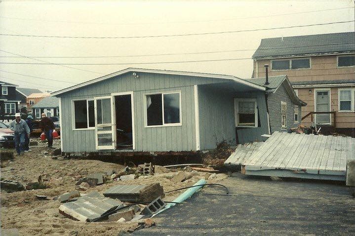
- Our second storm of note was the 1997 
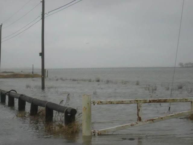
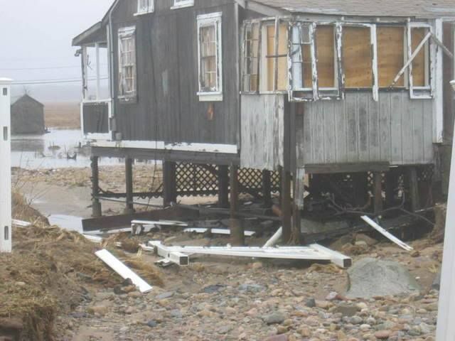
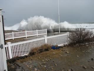
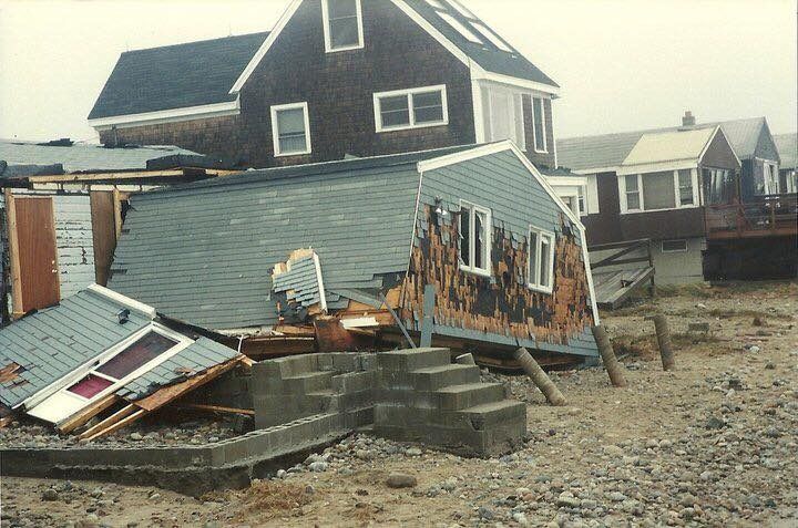
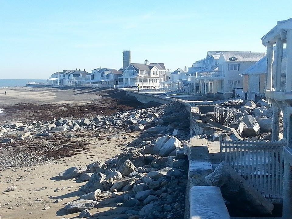
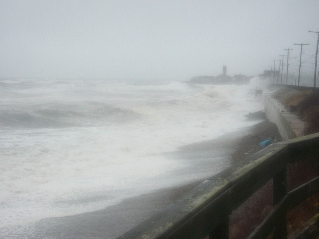
April Fool's Day Blizzard. Over 25 inches of snow fell on Boston, and coastal flooding tore apart the shoreline.

- Our third late-season storm of note was a 17-21 inch blockbuster that hit Worcester and areas north on April 28th, 1987.

I was a freshman at Worcester State College for that storm, and had just picked up a girl from West Boylston High School for a date... because that's how I rolled in 1987, playboy! We went to a movie, came out, and there were 6 inches of snow on the ground. We had an Italian dinner somewhere, and there was a foot on the ground when we came out of the restaurant.

I had only been driving for a year, and had zero savvy. We nearly hit a plow when we skidded all the way down a hill on Route 9. We also drove into a drift in some guy's yard in Berlin, Massachusetts. It ended well... the homeowner called his sons out to shove my car from the drift, and they came out single file... and each one was bigger than the last. "Don't worry about it, just steer" is how the father replied when I offered to make Katie drive so that I could get out and help shove the car. They literally lifted my car and threw it from the drift.

I got zero (0) play from that date, too. The only time I even got a hug as when we nearly crashed into the plow, and that may have been a case where she was trying to wrestle me into a position where the plow blade hit me first. I really can't blame her.

Anyhow, 17 inches of snow is about as much as we get that late in the year. If you get snow on your lawn after May 10th, you just saw a regional record.


Snowstorm Forecast Notes

As we publish when we wish, we had no need to keep updating our forecast. TV stations did not enjoy that luxury. They had to have something up every 6 hours or so, and it caused their forecasts to be all over the board.

Here are a few WBZ updates, just to show you how they flail about in the wind.

- March 13th... "Winter Is Over"

- March 16th... "Storm coming, worst of it west of 128"

- March 17th... "Danielle Niles tries to avoid giving a forecast for a March 20th storm on March 17th," although they do have the beginnings of a cool March Madness "Worst Storm Eva" bracket. I see a Blizzard of '78/1991 Halloween Gale final, although they forgot to put in the worst storm we have had in modern history, the 1938 Great New England Hurricane.

- March 17th, 6 hours later, different forecaster... "6-12 inches"

- March 18th, 12 hours later... "2 to 4 inches"

- March 19th, noon... "Storm will not form until it is past us, little or no snow"

- March 19th, 11 PM... "8 inches"

It's 2 AM on the 20th, and I can not finish this section yet... I have no idea what they will be putting in their 5 AM and noon updates. They may be calling for a heat wave or a hurricane for all I can tell.

(Update) 7 AM, today... possible "mammoth amounts" Their snow/rain line only touches the Islands and Chatham.


Our own March Madness brackets for Worst Massachusetts Storm Ever, Top 16 Seeds:

1) 1938 Great New England Hurricane

2) 1635 Great Colonial Hurricane

3) Blizzard of '78

4) Hurricane Bob, 1991

5) Worcester Tornado, 1953

6) Halloween Gale, 1991

7) Blizzard of 1888

8) 1898 Portland Gale

9) April Fool's Blizzard, 1997

10) Hurricane Carol/Edna, 1954

11)  Hurricane Donna, 1960

12) The Great September Gale Of 1815

13)  Winter of 2015

14) 1944 Great Atlantic Hurricane

15) The Triple Storms of 1839

16) Blizzard of 2005


Honorable Mention/Lower Seeds:

2008 Ice Storm

1698, reported 42 inches of snow in Cambridge

1831 Snowstorm, 3 feet on the Cape

1978 pre-Blizzard January snowstorm

2011 Springfield Tornado

Blizzard of 2013

1993 Superstorm

Saxby Gale, 1869

1969 100 Hour Storm

Winter of 1717

1996 South Shore microburst

Hurricane Belle

Hurricane Gloria

Hurricane Irene

Hurricane Sandy/Post-Sandy Wareham microburst

1960 snowstorm


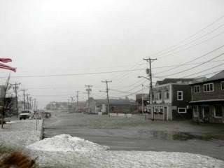
Our Forecast For Sunday/Monday's Entertainment Along The Coast:

There is a Winter Storm Warning for Plymouth County. Barnstable County only has a Winter Storm Watch..

As of this AM, it looks like the worst of it will fall along the Cape Cod Canal area through Hull or so..

Accuweather, which has also held to a consistent forecast, gives the village of Buzzards Bay 5-10 inches, and they settle on 5.3 inches if you add up their projected daily totals.  I added up Duxbury as well, and they get 5.1". A lot of it hinges on where the heavier snow bands set up.

(3:45 PM Update... 7 inches now forecast for Buzzards Bay by Accuweather)

I'm thinking that the Outer to Mid Cape gets 1-3 inches. The Upper Cape gets 3-6". The South Shore, South Coast and Rhode Island get in the 5-10" range. Middlesex and Cape Ann go to the 3-6" range, and Worcester is the drop-off point where you start clocking 1-3" again.

So, all of Plymouth, Bristol and Norfolk Counties get to share this one. Note that this current track cements a winter total where Cape Cod (or at least the Upper Cape) had more snow than Boston did. There is a very good chance that schools in this area will be cancelled tomorrow. You can blame that Al Nino motherf***er.

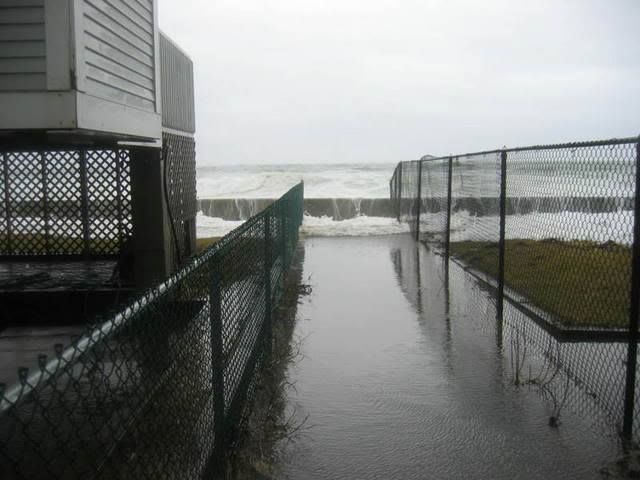
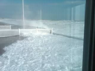
Winds should be gusty at the coast. It could be worse. The wobble in the track that gave the South Shore the higher snow also draws the worst of the winds back out into the ocean. An approaching full moon is happening, but we foresee nothing worse than some splashover. There's an 11 AM high tide on Monday that we'll watch for you... we might go to Sandwich for it.

The timing of the storm should be 6-9 PM Sunday through about Monday afternoon. Don't be shocked if you see some rain when it starts, or if the snow doesn't really drop until midnight.

The long-range forecast shows no more snow for this season, and it also seems to say that this weekend will be the last of the below-freezing weather. We'll be at 50 degrees on Wednesday.