Showing posts with label hull. Show all posts

Wednesday, January 13, 2016

Arthur & Pat's Going To Hull?

from the Arthur and Pat's Facebook page
People who were mourning the loss of a local institution will now be complaining about the long, strange road they have to go down to get to it.

My sources tell me that the owners of Arthur and Pat's (the D'Allesandro siblings) have bought the former Sea Dog restaurant in Hull. They will kick off the cooking this summer.

Arthur and Pat's was an iconic Marshfield restaurant known for their yummy breakfast menu and their unique customer service. Even with Italian owners, they were a crown jewel of the Irish Riviera. To my knowledge, breakfast there was one of the better South Shore hangover cures.

They announced the end of the road with Marsh Vegas last April.

Everyone from the area has their own favorite A&P story. I liked that the waitresses would tell you what you were having that day if they knew you well enough. I hated their banana bread, but I wolfed down several pieces over the years, rather than risk an argument with someone who cooked 2-5 of my meals every week.

Also, if they knew that you were an orphan, they'd insist that you eat everything on the plate before you were allowed to leave.

Local news legend Jerry Williams ate there every day he was able to, and Aerosmith's Steven Tyler once called it the best food in the world. It won Best Breakfast (and usually retired the trophy) in every local publication, and in several Boston ones.

There is a job fair happening at the former Sea Dog on January 14, from 12-2 and then from 5-7.  They seem to be looking for summer positions. I think that you can also apply to work at the Marina during this job fair.

The Sea Dog is on A Street in Hull.

Here's what I don't know:

- I'm not sure if it will be called "Arthur & Pat's."

- I also don't know if they will keep the Sea Dog name. The Maine-based business never really caught on with the flatlanders.

- I'm not sure if they will be open year-round.

- I'm not sure if this building will be in a flood zone.

- I don't know if they will keep the same basic A&P menu.

- Arthur & Pat's has a mighty reputation, but it sort of exhausts itself by the time you get to Hull. Most of the people on the Hull Facebook page I was monitoring had never heard of it.

So, Arthur & Pat's is not dead! They're just migrating. Strappin' on the feed bag in H-U-Double-Hockeysticks just got a lot better!


Tuesday, September 8, 2015

Come Hull or High Water: One Hull Of A Hurricane Preparation Article

"If I owned Hull and Texas, I would live in Hull and rent out Texas."
Hull sticks way out into the ocean, which is never a good thing in a coastal flooding scenario. It is very low-lying in spots, also a bad. It is also very densely populated, which complicates things further.

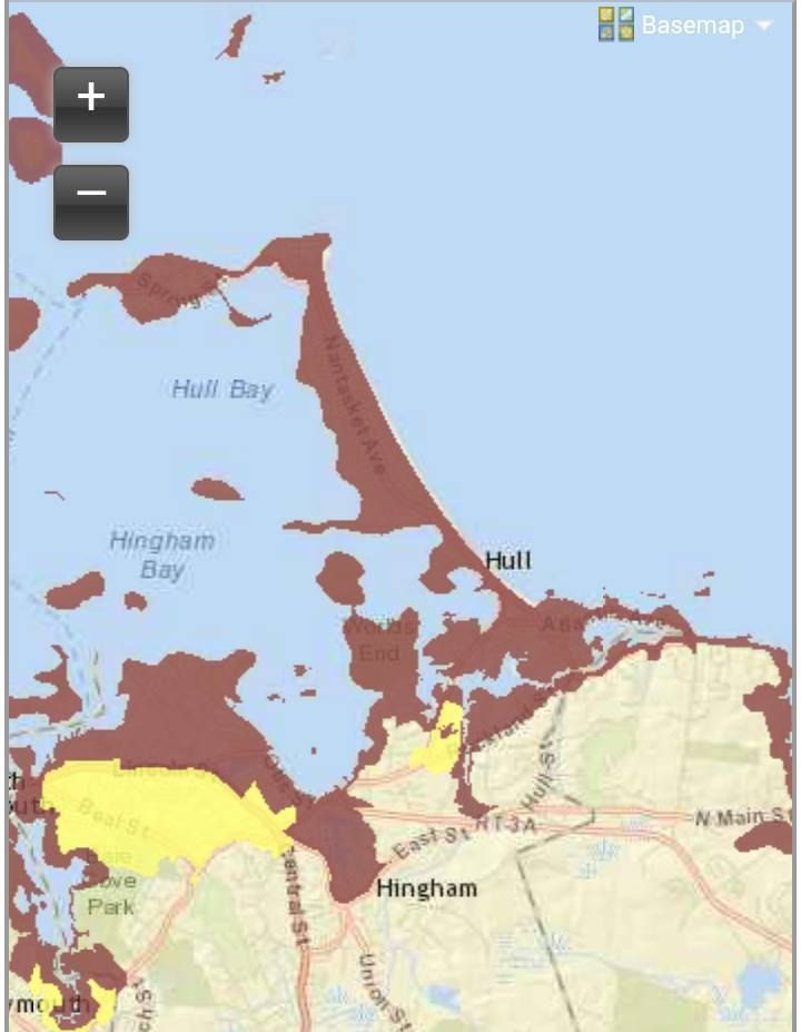
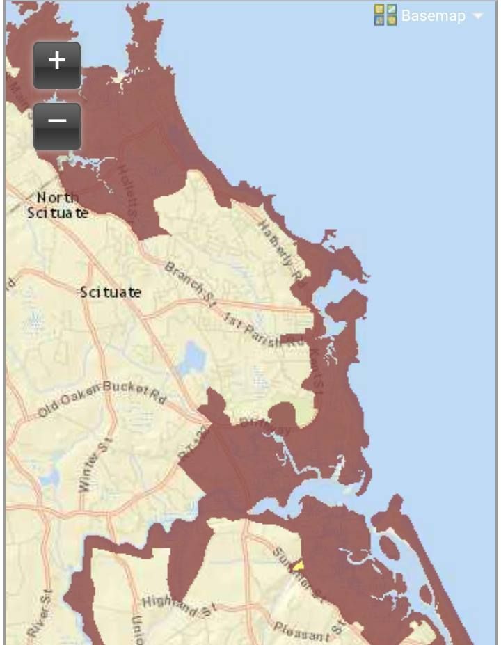
That map above is a Hurricane Inundation Map, from FEMA, MEMA, NOAA and NHC. The analysis is by ME, a lowly NWS volunteer spotter who happens to be Boss Hogg here at Cranberry County Magazine. The map is based on the zany-weatherman-titled SLOSH model of storm surge inundation.

"Storm surge" is the water pushed onshore in a storm. If you're standing at the high tide mark and a ten foot storm surge comes ashore, you'll be under ten feet of water. You can call it a Deathflow or Liquid Doom if it gets your people moving more quickly.

These maps depict the estimated storm surge for Hull in the event of a direct-hit hurricane arriving at mean high tide. They also show what sort of storm would e required to flood certain areas. They do not depict freshwater inundation that could result from heavy rain, sewer backups, and river/stream overflow.

The maps work like this:

Light Green = Category 1 storm. The Halloween Gale is a good-although-offshore example of a Category 1 hurricane, while the Blizzard of '78, though not a hurricane, is also a good model for estimating this sort of damage/risk.

Dark Green = Category 2 hurricane. Hurricane Bob was a weak Category 2 hurricane. Yes, "weak" and "Category 2 hurricane" are funny words to string together.

Yellow = Category 3 hurricane. We have only had five Category 3 hurricanes since the Other Man arrived in 1620, the last one being Hurricane Carol in 1954.

Red = Category 4 storm. We've had one in recorded history, in 1635.

Flesh = 100 Year FEMA Flood Estimates. This is the "hundred year storm" you hear people speak of, although you have to go pre-Colombian to find evidence (marsh mud samples are analyzed for otherwise unexplainable sand layering to determine prehistoric hurricane histories for areas with dunes in front of marshes) of storms of this power striking New England. According to my research, we got tuned up on to this extent in the 1100s, the 1300s, and the 1400s.

As we were saying before, you people are in a Hull of a spot.
"We're surrounded!" "We're supposed to be surrounded, we're paratroopers Hull."
Yes, you are surrounded... by water, and you don't live on mountains. When the water rises, it likes to come and visit coastal communities. That is going to make things very sketchy in H-you-double hockey sticks.

Hull could go from peninsula to island very quickly if a hurricane came to town. These maps help give you an idea of what sort of risk you face.

Hull does catch a break, in that a hurricane is almost never going to land a direct hit on Hull. It will come ashore on the South Coast, Cape Cod or Rhode Island before reaching Hull, and that will blunt the effects somewhat.

Hull will also benefit from the fact that hurricanes historically have a tendency to right-hook just before hitting Cape Cod, thus keeping Chatham and Wellfleet between the hurricane and Hull. That effect is erased when the storm plows through Cape Cod Bay, of course.

You can analyze the map for yourself, although I do feel obliged to note that Hull High will be underwater in even minor storms. The roads out will be blocked as well.

Talk to old-timers who were on Hull for Hurricane Carol or even the 1938 hurricane. Locals know stuff that FEMA doesn't, as odd as that sounds. I disagree with FEMA on my own neighborhood (Duxbury Beach), and my hurricane pedigree only runs back to Hurricane Belle. Keepers of the Old School actually watched hurricanes hit Hull, something most FEMA kids can't say.

Hull does have some high ground (World's End is safe from most storms, I was somewhat disappointed to discover), and you should both 1) know where it is and 2) befriend people who live on it.

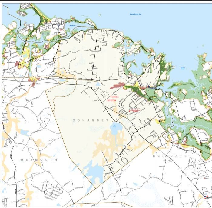
We can now move on to the Evacuation Map.

"Oh Baby, Please Don't Leave Me!"
This one is easier to read. Red means "They'd better leave," and Yellow means "You'd better leave, too."

Hull, in a hurricane, is a French word for "Flee." Pretty much everyone in town should give serious thought to a good Skedaddle. A good run is better than a bad stand. That water will be coming ashore angry.

You don't HAVE to go. However, the cop you read the Constitution to before the storm will also be the one who may have to pull you out of the floodwaters, so use your best discretion and stuff.

Hull will be a nightmare to evacuate. As anyone who drives home from a bar knows, there's really only one road out. Hull also enjoys the distinction of being the 4th smallest town by land area in the state, yet having one of the longer coastlines... while also being top 30 in population density.

Also note that you can be killed by a hurricane very far back from shore, even in areas not demarcated by either map. A river could overflow, power lines could fall, the winds could decapitate you with a pizza box, and you could very easily end up in a sharknado.

We want you alive. We want you alive for monetary reasons, as this site depends on you dropping by now and then. We want you alive for reasons of professional pride, i.e. "If they listened to me, they got out in time." We also want you alive for regular, nice-people reasons.

"I advocate hanging on as long as possible."


Check out MEMA Hurricane Inundation Maps for yourself... laugh at those less fortunate than yourself, while planning defense strategies for people trying to get into your house to seek refuge.


Wednesday, August 5, 2015

Eastwick Meets The East Wind: A Cohasset Hurricane Primer


Hurricane season is upon us, and we are nearing the peak of it.

Now, we're in Massachusetts, and we haven't been hit dead-on by a hurricane since the 1990s. That means that we don't get them often, and it means that we are long overdue.

They aren't a frequent enough event that you should walk around wringing your hands or anything. However, there are certain things that a wise person might do which can eliminate a lot of the hand-wringing.

Ironically, the first step to a peaceful mind is to view some Disaster Porn!


We have two maps for you to look at, and they are specific to your town. One is for Inundation, and the other is for Evacuation. They pertain to a direct-hit hurricane hitting your town at mean high tide.

"Inundation" means "covered in water," although you can call it a Deathflood or a Sea Plague if that gets your people motivated. It refers to which areas in town will be covered with seawater (important distinction, these maps do NOT project freshwater flooding) if you play host to a hurricane. 

The map for Inundation (the top one) is color-coded, with light green, dark green, yellow and red. Those colors equate to which areas will get wet in what kind of storm, i.e. Category 1, 2, 3 and 4. Where you see colors changing on the map, that's where the experts think it will require a greater storm to flood that area in seawater.

The maps for Evacuation (right and below) are less complicated. If you look at the Inundation map for a moment and then look at the Evacuation map, the logic will eventually make sense. The red areas of the map essentially say "Those People Have To Leave," and the yellow areas say "You Have To Leave, Too."

See how you compare to your neighboring towns with the complete list of Inundation maps and Evacuation maps!

Remember, storm surge is not the only threat from a hurricane. Things like falling branches, freshwater flooding, lightning, flying debris, slick roads, tornadoes, downed power lines, looters and a thousand other variables can mess you up plenty when the barometer drops heavy.

Cohasset doesn't get the storm-love that Scituate gets. Part of this is from the more northern tilt to her beaches. Part of it is the armor of a rocky coastline, as those offshore rocks and ledges can knock the oomph out of a storm wave. A great part of it is Scituate sticking her Scituate Neck out to block Cohasset from the full effects of the east wind. 

In the end, Cohasset slides a bit. If you see a rich person's beach house getting washed away, it's more likely to be from Duxbury than Cohasset.

We sort of butchered the part where we cleanly upload the Cohasset evacuation map, but enough of the Scituate and Hull maps will bleed into C City that you can get the general idea. With evacuation, the general rule is When In Doubt, Get Out.

Most of Cohasset's housing is in the east side of town, and rightfully so. This will put many people in the Inundation area, and, shortly before or after, in the Evacuation area. Beach Street and Atlantic Avenue will live up to their names. Joy Place almost certainly will not.

No elitist, Mother Nature will also have herself a few swings at Jerusalem Road. One of the great differences between hurricanes and tornadoes is that the rich suffer disproportionately in coastal storms due to their habit of buying up shoreline property, while tornadoes- using logic which only they understand- prefer trailer parks.

The worst omission from my evacuation maps was the area of Cohasset along the Scituate border, which has a coastal river as the dominant feature. Ocean water loves to surge up coastal rivers during hurricanes, and Cohasset will see this first hand if a major storm arrives. Anything west of Scituate Neck, and anyone along a river, should be evacuated.

You can view Cohasset's evacuation map right here.

As always, know that hurricanes are rare in these parts. They have to plow through either the South Coast or Cape Cod (and then fight through the South Shore) before they even think about Cohassle. By the time they arrive, they will be considerably weakened.

Still, you want to be careful if the weather gets nasty. There are plenty of ways to die in Cohasset during a hurricane, and most people only need one.

Remember, as we say on Duxbury Beach, the other 364 days of the year look sort of like this!