Showing posts with label nor'easter. Show all posts

Wednesday, March 16, 2016

Nor'easter Incoming For Sunday/Monday?


Winter wasn't going to let us off the hook without one more backhand slap. Did you really think it would?

We've had a mild winter, a welcome change after all that Siberia stuff we had a year ago. Cape Cod may have gotten a bit more than her average for snowfall, but a winter where Cape Cod outsnows Boston is an anomaly.

We have a shot at some more snow this Monday, as a storm will develop offshore and see how close she can get to New England. She'll arrive during what may be our last blast of cold weather this weekend.

She could very well miss us. We're several days away. It is one of those two-track scenarios where Track #1 means that the storm goes out to sea, and Track #2 means that we get a rain/wind/snow event.

There's a full moon on Wednesday, and that could provide some Aftersurf if the storm throws waves at us from afar (she's expected to hit Canada as a blizzard), especially Tuesday.

We're too far away to say for sure what will happen, and even if we guess, we have no idea of how much snow will fall, where the rain/snow line would set up and a zillion other things.

I saw no snow totals forecast. I did see wind gust charts giving us gale-force winds. The storm would clip Massachusetts, and mainly be a SE Massachusetts event.

If it hits, the weather would go downhill Sunday night. The storm would be offshore on Monday, and be done with us by Monday night.

Again, it may miss us, most likely will... we just want you to keep an eye on the weather for the next few days. We'll keep you updated.


Wednesday, February 10, 2016

Coastal Flooding In Green Harbor And Duxbury Beach

Waves breaking on houses, Ocean Road North, Duxbury...
We went off-Cape to see what sort of action that the South Shore was getting from Momma Ocean. A blizzard had just blown through town, and we were getting reports of wild surf on Duxbury Beach. We were on our way up the moment we got Logo on the bus (2 hour delay). We made it just in time for high tide.

Surf photography is often easier if you go the day after the storm. The storm is usually just offshore a bit, and it is slow-rolling waves back to the coast. Unlike waves on the day of the blizzard, you can go outside and shoot waves without getting soaked by rain or blown around by the wind.

The Great Salt Marsh, Duxbury
The plan was to go to Duxbury Beach, hook up with some friends, and watch the storm from their house. That plan came to a stop when we were unable to get down Gurnet Road.

Duxbury Beach often floods backwards, as in "via the marsh." This happens before high tide, which brings the waves and their splashover water into the mix as well.

We made it through the first puddle easily enough, but we saw an SUV struggling with the next puddle. We called "No Mas" like Roberto Duran.


We tried the Bay Street/Bay Avenue turn where Marshfield meets Duxbury Beach, that wasn't happening, either.

We were in a Dodge Stratus, and she sits about 4 inches from the ground. She is not built for plowing through street flooding, especially where it's 11 AM in Duxbury and we have to get a kid off the bus at 3:30 PM in Buzzards Bay. It's tough to keep that schedule with a dead car.

We took pictures of the flooded roads, and they came out so well that we decided to double up on flooded-marsh pictures.


We finally made it to the beach around where the Green Harbor General Store is. We didn't make it by much, as the bridge by the Green Harbor Lobster Pound was almost washed over... as you can tell.

We were running the risk of getting trapped, but I liked our chances of escaping.

This was my favorite jump-off bridge as a kid, although I think I'd break both legs if I even stepped off of it now.


I parked down where that SUV is in the upper right, and this gave me access to the Burke's Beach section of town for my camera work.

Burke's benefits from having a jetty, which keeps the water off the houses.

OK, it does so when it's above water.


Small print, kills you every time.

The risk was worth it, because I ended up being behind the waves that were breaking on the houses along Green Harbor and Duxbury's seawall. You can do that due to the wave-blocking presence of Brant Rock, and due to the curvature of the seawall.


I only got my feet wet, and that was because I let my attention wander.

This is bad, but not as bad as it looks. The spray is the water hitting the seawall. This throws up spray, which catches the wind and gives me cool shots.


Brant Rock got it as badly as Green Harbor did, if not worse. BR, remember, is the part of town that got beaten down last winter.

I would have headed over, but I didn't want to go through the Esplanade splashover puddle... which, the last time I checked, encompasses all of the BR business district.


These are good-sized waves for the Duxbury Beach/Green Harbor region.

I saw at least one scientist paper claiming that the maximum height that waves can reach on this strip goes around 5 feet, but I saw much bigger waves during the Halloween Gale and the Blizzard of 78.


My camera actually has color and everything, it just was a grey day.

These shots are mostly Green Harbor, but some Duxbury Beach can be seen on the left end of any given pic.

Not these ones below, I zoomed in on Vegas. Duxbury starts about where the giant break in the seawall is.. you know, the one you can't see in these pics.


"The impact will blow trees back and crack statues."

Thanks to our host for the day, Green Harbor!

.

Monday, November 9, 2015

Nor'easter Coming This Wednesday


...WIND ADVISORY IN EFFECT FROM 1 AM TO 4 PM EST WEDNESDAY...

THE NATIONAL WEATHER SERVICE IN TAUNTON HAS ISSUED A WIND
ADVISORY...WHICH IS IN EFFECT FROM 1 AM TO 4 PM EST WEDNESDAY.

* LOCATIONS...INCLUDE CAPE ANN...THE PLYMOUTH COUNTY SHORELINE...
CAPE COD...AND NANTUCKET.

* WINDS...NORTHEAST 20 TO 30 MPH WITH GUSTS UP TO 50 MPH.

* TIMING...1 AM TO 4 PM WEDNESDAY.

* IMPACTS...STRONG WIND GUSTS WILL DOWN SMALL TREE LIMBS AND
BRANCHES...POSSIBLY CAUSING ISOLATED POWER OUTAGES. DRIVING MAY
BECOME DIFFICULT...ESPECIALLY IN HIGH PROFILE VEHICLES.

PRECAUTIONARY/PREPAREDNESS ACTIONS...

A WIND ADVISORY IS ISSUED WHEN SUSTAINED WINDS ARE FORECAST TO BE
31 TO 39 MPH OR GUSTS WILL RANGE BETWEEN 46 AND 57 MPH. WINDS
THIS STRONG ARE CAPABLE OF DOWNING SMALL TREE LIMBS AND
BRANCHES...POSSIBLY CAUSING ISOLATED POWER OUTAGES. DRIVING CAN
ALSO BE DIFFICULT...ESPECIALLY FOR HIGH PROFILE VEHICLES.


Ten foot tides on Wednesday morning, new moon heights.

Plymouth tide chart

Duxbury Tide Chart

Marshfield (Brant Rock) tide chart

Scituate tide chart

Cape Cod Canal (Sandwich end) tide chart

Barnstable tide chart

Provincetown tide chart

Chatham tide chart

Wellfleet tide chart


Thursday, November 5, 2015

1991 Duxbury Beach Storm Damage From The Halloween Gale


Living on the shore of the sea does have some benefits, but there is what actuaries and lawyers call Inherent Risk.

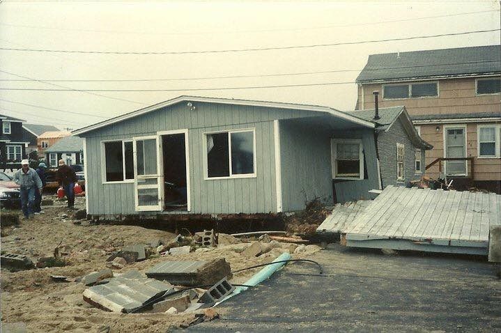
We're going to explore some of the consequences of that risk in today's article, which heavily leans on pictures given to us by the Bedford Family, formerly of Ocean Road North on Duxbury Beach.

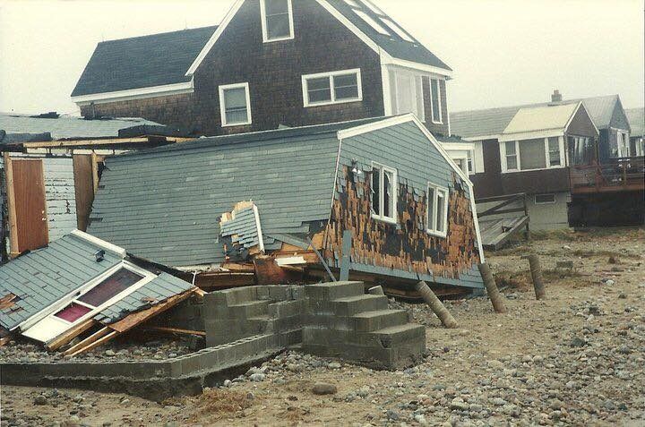
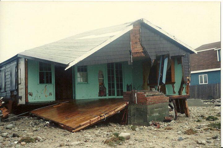
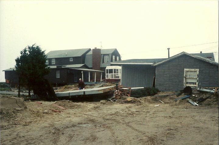
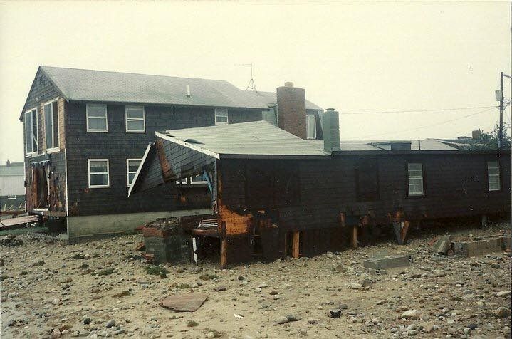
They show damage from the 1991 Halloween Gale, which people from Inland might call The Perfect Storm or the No-Name Storm.

No one who lived through it calls it "the Perfect Storm," as it is sort of cruel to use positive superlatives when talking to victims. "Hey, Jackie O.... sorry about the dead husband and everything, but you gotta admit, that was some splendid shooting."

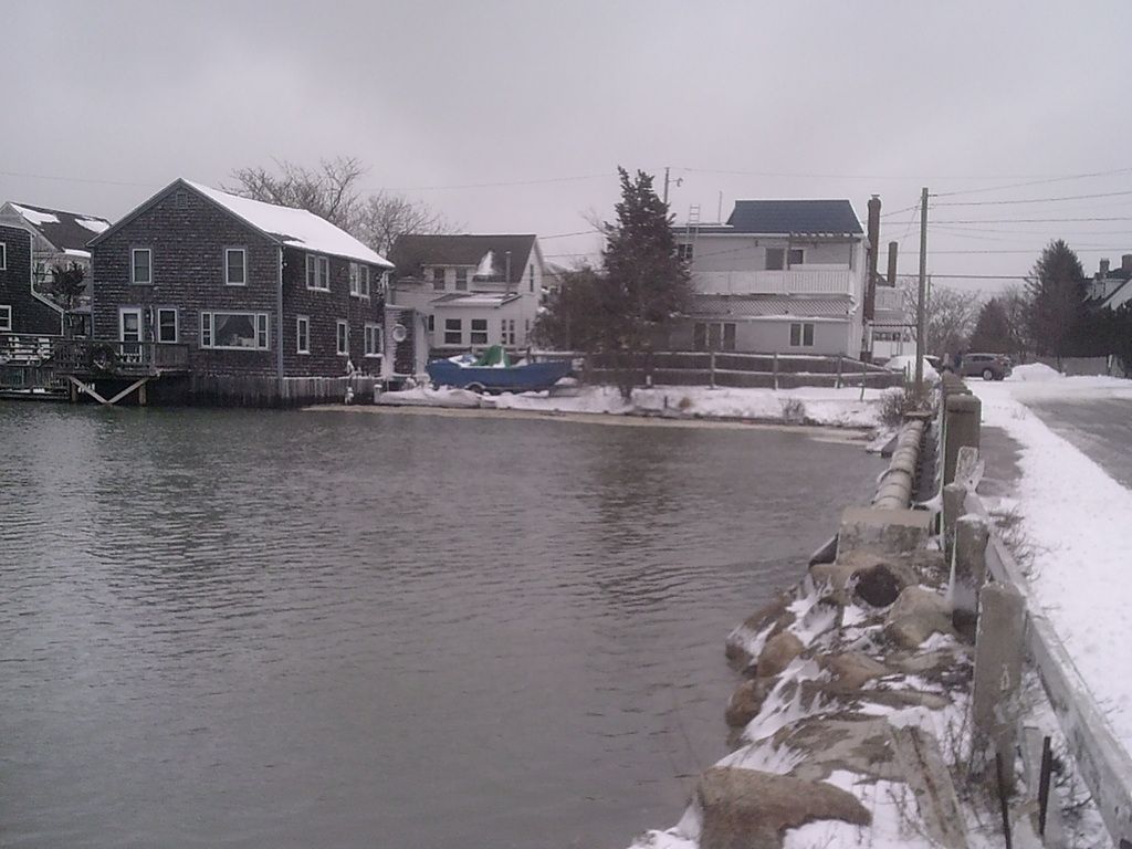
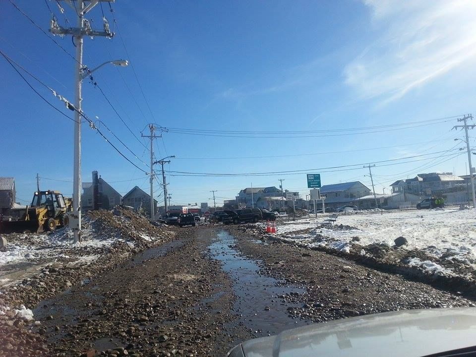
The only non-Bedford, non-1991 picture is the one above. It is from the Federicci family, and shows an incoming high tide during a nor'easter last year.

Everything else was post-Gale carnage.


The gale arrived around Halloween Eve, Devil's Night. The local forecasters blew it (the better forecasts spoke of a storm at sea), and we had practically no warning.

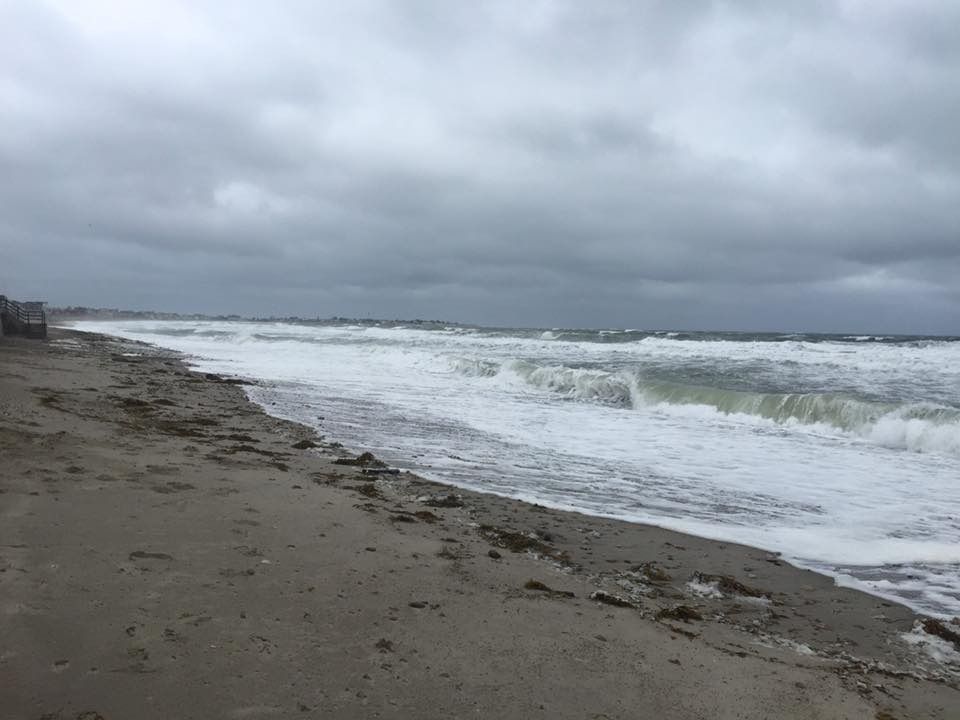
A hurricane offshore (Grace) met a nor'easter, got absorbed, re-formed into a hurricane, and spun around in a crazy course off of the Massachusetts coast. Mammoth waves with hurricane winds behind them pounded the Massachusetts coastline. Damage was in the hundreds of millions in 1991 dollars.

The storm was never named, even though it was a hurricane. This was officially to avoid confusion, but also most likely because there was a bit of shame involved among the weatherheads. To be fair, the hurricane never made landfall, and the nor'easter (which later became the hurricane) did most of the damage.


This storm gentrified Duxbury Beach faster than a BMW parade of yuppies.

Some people could take no more, and sold out. The people who bought the old propertuies built them up. Other people cashed in insurance checks and built much larger houses. Throw in the stilts under the houses, and this storm changed the whole skyline of the neighborhood.

The houses you remember from the 1960s and 70s were gradually and emphatically phased out by the Halloween Gale, and the Blizzard of '78. Cottages in front of the dunes were gone by 1978. Little cottages on the seawall were leveled in 1991.

Every house you see here was rebuilt into a much more valuable property. This drives up property values, leading other families to sell. A cycle ensues, and the Irish Riviera fades into history.


The storm was a monster, every bit the equal of 1978. You'd rank them 1 and 1A. The Gale far surpassed damage done to Duxbury by Hurricane Bob, who had visited about a month and change before. Bob was a cakewalk in Duxbury, but the Gale was taking no sh*t.

This house washed back into the street. It was not the worst destruction of a house on that street, as a cottage at the other end of Ocean Road North pretty much disintegrated.

Even the houses on Cable Hill lost decks, which is very unusual.

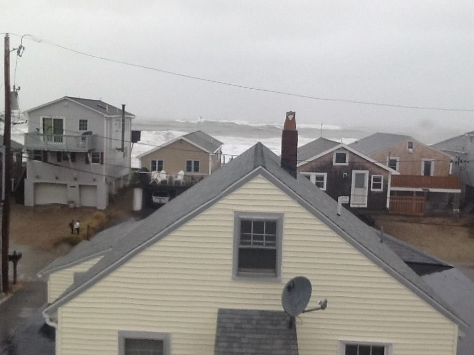
The Gale was a slow mover, and it hit the beach with 8 storm tides. This article is being published on the 24th anniversary of the day when you could finally get back into the neighborhood and stay for a high tide.

Everyone with a brain had fled on the morning of the 30th, when waves were smashing the seawall 4 hours before high tide. Smart people run to get away from stuff like that.

Unless you're me, of course... then you run to Get To the besieged house so you can watch the storm.


A friend of mine and I watched this storm from the 2nd story of 65 ORN. I had to swim to get to my house. I had to wade through my house to get to an upper floor. We had ostensibly gone there to rescue a schnauzer, and decided that we wouldn't survive an escape attempt.

The episode of Beavis & Butthead where they go to the trailer park to watch a tornado hit is a good allegory. It even rivaled the damage ("A tornado can smash a poodle's face with a brick!" "Yeah, it can rip out your heart and show it to you!") the boys were seeking to witness.

The storm was as nasty as they tell you it was. The neighborhood was under about 6-10 feet of water, depending on the wave wash.. The ocean was level with the seawall, meaning that waves could just roll right into your house and smash it. My yard was level with the seawall, so waves would actually break on my house. I watched a few hours of it from inside my house, a few hours more from Cable Hill.

The waves were 8-10 feet high, which is funny because I have read a storm damage potential assessment for Duxbury Beach which said that waves can't get beyond 6 feet.

If they had YouTube back then and if I had a video camera, I'd be as YouTube famous as Jenna Marbles or the Epic Meal Time guys. We were right in the belly of the beast.

Wednesday, October 7, 2015

Seawall Repair In Marshfield


Marshfield fights back against Poseidon this week, as they scramble to repair ruined seawalls before nor'easter season kicks in.

They dodged a bullet last week, as a powerful storm battered the coast for several tides. It never really got biblical however, and things appear to be sailing along well enough this week.

The town is fixing 1000 feet of seawall, mostly along Foster Avenue. It is replacing a wall that has been up since 1931. Recent storms have smacked it around, with the dark spectre of Attrition also having a loud say in matters.


There's no need to fear... FEMA (or the US Army Corps of Engineers, or the DPW) is here. Your tax dollars at work, as they say.

Left without maintenance, these walls would crumble into the sea. When that happens, it opens up the houses of that part of town to direct wave impacts. It also brings about great inundation. Relocation would involve re-settling 10000 souls or so.

That also means losing valuable property tax revenue, business money, jobs, tourist loot and any other of the zillion permutations that would come with telling the Coasties to eff themselves.

It's a lot like gun control.... ideally, there would be no development in vulnerable coastal areas. However, once you have it, it's easier to try to regulate it than it is to go door-to-door seizing property.

"Easier" in this case involves millions of dollars in seawall repairs, but that's cheap when compared to worst-case scenarios.

Joe Deady took the non-blurry, useful pictures.

This wall will be two feet higher than the present wall, and 84 years younger. They'll be using that, uhm, like, modern concrete or whatever they put in that wall. Vauban, I am not.

This maritime Maginot Line is Marshfield's magic against Mean Momma Mer.

Marsh Vegas, depending on how the storm winds blow, sort of alternates the title of First Town That Atlantic Storm Waves Hit Without Breaking On Cape Cod First between themselves, Scituate and Duxbury. This means that she takes heavy shots from the storm waves, and they kinda need the 2015 version of the seawall.

The town (through a loan from a state seawall fund) will split the costs of the project with the state, which will provide half of the necessary cheddar via a grant.

Total cost? $3.94 Million.

If this wall were built by the Donald, it would be taller, thicker, and deeper in the ground... and Mexico would be paying for it.
However, Vegas was happy to pay their half of the loot. Seawalls are like divorce... they cost so much because they're friggin' worth it.

The locals allowed the town some eminent domain mojo, so they can do future repair and maintenance work. From what I saw of this in Duxbury, it may cost you a foot of the lawn if they have to dig down for some maintenance.

That's a small price to pay for a wall that I'm pretty sure is thicker and tougher than the wall in Berlin that the Soviets used to keep the eastern Nazis penned up.

The whole wall is there to protect the Port-a-Potty, which is actually a cleverly-disguised Stargate.

Hawk-eyed readers will notice the 2015 date carved into the top of the stairs. I was gonna park and get a better picture, but the locals are sort of touchy about stuff like that.

Vegas had a tough week, with murder and nor'easters dominating the local news. The people of this particular neighborhood also have had a lot of heavy equipment erecting a Soviet-style cement project just outside their windows. These are the very last beach days, and they've had a few weeks ruined by both storm prevention maintenance and the storms themselves. I didn't want to throw "some moron journalist parked in my road" onto that list.

I never went to school for Journalism, and for most of that time where real reporters were learning Ethics from some professor, I was out learning how to break into cars and stuff like that.

However, I try to be a seamless and respectful addition to any neighborhood I may be visiting.


They still have a lot of work to do for a project that is supposed to be done by December.

Today's entertainment was on 13th St, and they have to get down to 9th for this phase of the project They eventually will go down to 3rd, but I don't have an ETA for that one.

Even if you aren't from Vegas, you should pay close attention to how things go down here. Massachusetts is lined with seawalls, and they cost a lot of money to repair.

Feel free to check our very-much-relative article on seawall repairs that we posted up on the world last summer.

Marshfield is laying the blueprint that a lot of towns may be following as their ancient seawalls fail. This could be happening in your Duxbury or Falmouth beach neighborhoods soon enough.

Otherwise, this could be happening...


Sunday, October 4, 2015

Surf Check, Round 3

We worked the northern shore of Cape Cod for this article... not really because it's better than Scituate or Duxbury, but just to get a better feel for the region. We're in this game for the long haul, and we may as well use lesser storms to pick up some local knowledge.

We went from Sandwich to Dennis, but the camera didn't like wet work. As bad as these pics are, know that they were the GOOD ones.


This was the waning storm tide, very much sustained by the high winds.


We also wanted the north-facing aspect, as the wind had shifted somewhat.

Some good old-fashioned Yarmouth sea foam.


Water, sand, lifeguard stands., dunes, snow fencing... everything you want from a beach... too bad this is the Sandy Neck Beach parking lot.


In high winds, it's better to shoot from behind sand and stone.

I wish this came out better, I had elevation on my side here.

The storm did her best to get the roads sanded.

One big difference that I have noticed between northern Cape Cod and South Shore beaches is that the Cape can sometimes get away with a jetty-style wall.

The storm god of Dennis.

My Duxbury people got some better shots.


You can get some nice shots from upper decks over the seawall.

Our Mommy photographers are not at all afraid to stick their cameras into the belly of the beast.

An annual post-storm tradition in Duxbury is the Stair Harvest.


Jumping the Sandwich boardwalk with a parasail thingy in a nor'easter ROOLZ.

Said boardwalk in Sandwich


Beach plum berries are ready!


If you ain't from Town Neck Beach, don't come to Town Neck Beach.