Cranberry County Magazine's photographers engage in a little camera fight before the fire gets lit.
Because there was a 9 PM high tide, they had to either light the fire at 7:30 PM or light it at 1:30 AM. This also led to smaller fires. Remember, kids... always give the bonfire enough time to burn itself down to ash before the tide hits it.... otherwise, you get a beach full of charred wood for the rest of July until the tide pushes the debris down to the uninhabited parts of Duxbury Beach.
One thing that stood out... only Duxbury had fires. This was one of the more southernmost fires, and there were no fires north of Killian's (a locally notorious Duxbury Beach party family) on the Duxbury/Marshfield line. Marsh Vegas has put their foot down on bonfires, it seems. They were a Loyalist town during the Revolution, so July 3rd parties must seem like doing tequila shots off of the casket of a loved one. Still, someone should have put a fire up.... shame on you, Green Harbor!
Poorly-timed high tides can't stop the fireworks, babe. Duxbury Beach spends a lot of money on personal-use fireworks. Several people I know there had enough gunpowder to defend Little Round Top if they had to. The whole place on July 3rd sounds like films I used to watch of Beirut during urban battles. It was bad enough that I thought I had PTSD for a little while, but I figured out it was just regular psychopathology.
A different vantage point....
Here's me butchering a shot where God had already spotted me the dusk's early light, the flag, the cute kids, several neighboring bonfires and even the rocket's red glare. I later dropped my camera on the beach somewhere, which- judgng by the quality of my shots- was probably a good thing. Shed no tears for Cranberry County Magazine, though... it was a $27 camera that I had owned for a year.
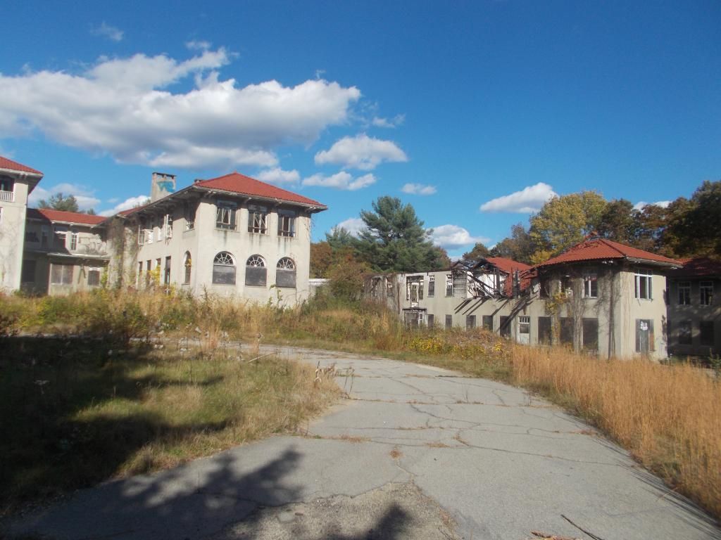
BEFORE RECONSTRUCTION.... variously known as Old Man Bradford's house or Tai Chi's house, it had been falling into disrepair for decades. You can see the channel dug by storm tides washing through the property
ALSO BEFORE.... The area behind the cottage in question, a meadow that is the lowest-lying place on Duxbury Beach. This picture and the picture above are from a 2007 nor'easter.
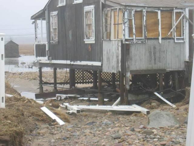
DURING.... Shot from Gurnet Road, the shanty has been torn down.
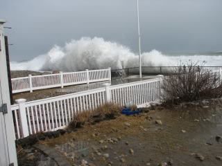
AFTER.... 71 Ocean Road North, reporting for duty. We'll see how this Irish Riviera gentrification job holds up against the nor'easters...
... like this one, with waves hitting the seawall right in front of the new house.
One of the common local myths circulating around any town in Massachusetts comes to life every time someone says "No town in Massachusetts has more liquor stores than (insert his town here)." I have heard the term ascribed to Provincetown, Worcester, Amherst, Winthrop, Scituate, Clinton, Bridgewater, Marshfield and a dozen other towns. The easier to swallow version of this myth is the same quote, but on a per-person basis.
Opinions vary wildly, and this is probably one of those articles where I'll get told to eff off in the comments section. I'm good with that. I will say that there are different lists with different criteria.
Boston generally wins Drunkest City In America. That title is shouldered by a heavily Irish population base, an unmatched pile of college kids, a nice flow of business travel, long suffering Red Sox fans, a solid nightlife industry and did I mention the Irish?
Roadsnacks, in an influential 2015 study using much of the same criteria as me (but using other factors like Package Stores, Divorce Rates and Twitter references), came up with a Top Ten of:
Plymouth
Scituate
Salem
Walpole
Adams
West Yarmouth
West Bridgewater
Andover
Hudson
Newburyport
WCVB, using a self-reporting technique of "Has More Than Five Drinks Per Session" and going by counties, had:
Hampshire County
Nantucket County
Sufflok County
Plymouth County
Barnstable County
Dukes County
Bristol County
Essex County
Franklin County
Middlesex County
Norfolk County
Worcester County
Berkshire County
Hampden County
They had Hampshire standing alone, Nantucket and Suffolk taking Place and Show, a glut with the same ranking (on that list, it runs from Barnstable to Norfolk Counties with each holding the same score) and the non-UMass western regions being a bit drier.
There are dry towns in the state where no Licka gets sold. Those towns remind me of the Civil War story of the Irish soldier slipping off the march into a dry-town inn and asking the innkeeper for "a glass of water, with a wee bit of the Creature added, unbeknownst to you or myself."
I was going to try to find out Liquor Stores Per Town, but that seemed like too much work. There exists no easily-Googled database. I'd have to Google up which towns have how many liquor stores, then divide or something by how many people live in each town. A good method, granted, but very work-intensive for a sunny Saturday morning in May. There would also be a large Margin Of Error.
What I shall instead do is use this map of 2011 liquor licenses per town from the Boston Business Journal. Old numbers, obsolete, but providing insight. I can then cross-reference my numbers with the population figures of the town in question, and... Voila! We have a new stat, one which I will name once I think of something catchy.
(Editor's Note: Or he can save 12 hours of math by just using this chart)
This map is just for places you can drink IN. Take-out drinking from packie stores isn't accounted for on this list.
I may as well make a few guesses here before I start looking at the numbers, thus becoming like more enlightened than you. Once I have had a look, I'm disqualified from guessing. You'll catch up to my enlightenment once you read the article, but by that time, I'll be looking up some other new ish, and the cycle will begin anew.
I'm thinking that "the Irish Riviera" will miss out on her rightful title, mostly because "Cape Cod" is a touristy place and will have her numbers padded by people on vacation. I have no doubt that New Beige and Fall-down River carry the "South Coast" on their backs, but if places like Acushnet and Mattapoisett represent hard, the region may be able to take down a contender.
Anyhow, here are the towns from our region and their ranking on the list. The criteria is residets-per-liquor license. If I had package store numbers, these rankings might be radically different.
Rank.... Town.... Residents... Licenses... Residents per License
1PROVINCETOWN3,3906255
Provincetown takes the title. At least one publication that I saw summed it up as well as I can... "Tourist haven in the summer... desolate, isolated winters."
"55 residents per license" means that, if every single man, woman, child and baby in Provincetown went out for a drink to a local bar, each bar would only have 55 people in it... less, once you factor out bar employees who live in Provincetown,
By contrast.... if a similar event happened in Duxbury, there would be 1444 people in each bar. If it happened in Boxford (ranked #318 and last in the state), there would be 8600 people in each bar.
The Cape represents hard, although runner-up towns like Great Barrington could complain about tourists and summer people swelling the numbers. If you assume that summer people double the population of Chatham, and that there are also a disproportionate amount of hotels filling up with families, you might have to triple or even quadruple the licenses-per-town rankings. All of a sudden, these supposedly hard-drinking Cape towns start tumbling to 150th in the state.
Provincetown is immune to that. Tripling their RPL only moves them to 3rd in the state.
Monroe- ranked second in the state, just above Wellfleet- has 1 license in a town with 96 residents. By contrast, the Mayberry hometown (may have been County, or both town and county) of Andy Griffith fame had 5600 residents... in 1968.
Let's pause right here to tip our glasses to the western part of the state. While I'm only showing EMass towns, rest assured that about 90% of the towns that I'm leaving out are in the Berkshires.
Both of the islands assert themselves mightily. Island people are sort of kin to mountain people. Both are a bit strange. It's a different sort of strangeness, but it shares a common intensity. They're both about equally lost in a city.
Rankings 50-75 have a few trends jumping out at me.
1) The South Coast is beginning to assert herself. Props to Seekonk for sliding into the top 50. Mattapoisett, Fairhaven and Wareham also step up to the bar by the time that #75 is called.
2) The South Shore and especially the Irish Riviera took awhile to show themselves. Scituate is nowhere to be seen.
3) I wonder if (and how much) Foxboro's numbers are pushed up by the Patriots being in town. I don't get out to Foxy Bro as much as I used to, and am not sure what sort of effect 8 home games (and X playoff games any year) has on the town's drinking establishments. They say that businesses on Cape Cod are made/broken by 8-12 weekends a year. I wonder how much 8-12 weekend days a year is worth in Hooch Sold?
Cape Cod is starting to fade out... not because we don't drink hard enough, but because we've exhausted most of our towns earlier in the rankings.
Bourne does drink harder than Boston, something I'm a bit shocked to see. If Boston had better beaches, they might be able fight their way up the list a bit.
Note that many of Boston's Irish fled Boston in the 1970s, driving up the numbers in the otherwise sleepy Irish Riviera.
New Beddy closes out our presence in the top 100. 30% of the top 100 are towns in our coverage area.
Fall River is pretty much right in the middle of the rankings. New Bedford and Fall River, which I thought would carry the South Coast, ranked a modest 87 and 158 respectively. Seekonk (44), Mattapoisett (60 something) and the Wareham/Fairhaven team (74 and 75) all represented harder.
At least 10% of the liquor licenses in Wareham are held by places that only serve breakfast. (Your Hometown Here) may have more or less, I just wanted to float that stat out there.
Sandwich finishes off the Cape.
Fall River trails Quincy, which is the same size but more Irish-heavy. The Squantum neighborhood of Quincy is about as Irish as it gets.
If a bar gets their license revoked in Scituate, this thought-she'd-be-ranked-higher Irish Riviera superheavyweight would fall out of the Top 200. She'd rank below hard-living Oakham (pop. 953, 2 licenses) in the state
If the Gurnet Inn was still open, sleepy Duxbury would be ahead of Brockton and Lynn.
Rochester and Dighton hold down the South Coast, and Lakeville is the more "Let's go out" of the Freetown-Lakeville conglomerate.
Duxbury and Sandwich ranked similarly, something our staff predicted. Both towns are sort of the Rich People Conscience of either Cape Cod or the South Shore (I'm told by our Fairhaven editor that Dartmouth fills a similar role on the South Coast). Granted, Sandwich is about twice as pubby as Duxbury, but the Cape is sort of off the scale due to summer tourism.
"Ahhhhh... nice beach here.... soft sand, warm water, clean air... think I'll take a swim. Oh, look! A seal! What's that shadow swimming next to him?"
Due to the cycle of the sea, seals began hanging out in large numbers off Chatham. After that, it becomes simple algebra.... sharks eat seals, seals hang out at Chatham, so therefore...
A great white shark goes 10-20 feet long and can bite a human being in half. If he's not looking that closely or if he's really hungry, we look kind of like seals in the right (wrong) light.
The last fatal shark attack in the general area was off Mattapoisett in 1936, but sharks are more prevalent now than at any point locals can remember.
To be fair to the sharks, humans are out on their turf. You can't blame one for wanting to try some People Food now and then.
Suicide Alley
A nasty stretch of Route 6 turns to 2 lanes- one East, one West. You're on a divided highway, but then cars start coming at you from the other lane. It's disconcerting. Suicide Alley runs 13 miles, from exit 9A in Dennis all the way to Orleans.
I don't think any other stretch of road has a worse reputation on Cape Cod, and no other ones have such an ominous nickname.
If someone from Cape Cod says "There was this terrible head-on accident..." someone else from Cape Cod will usually finish with "Suicide Alley?"
If other states have a Suicide Alley, they are not respected by Google. I saw no other Alley mentioned.
Pilgrim Nuclear Power Plant
It's actually a fairly nice part of the state... coastal, beachfront, in the pines. It's not melting down or anything, and any leaks presently are low-key. They have a lot of spent nuclear waste sitting around (in overloaded storage facilities), and they can't find anyone to take it off their hands.
However... the worst case scenario actually makes this the top risk in the general area. Imagine a massive accident there? With almost all winds imaginable, the radioactivity released could blanket Cape Cod.
At that point, Cape Cod becomes Cape Chernobyl. Farming would be viable in Sandwich in about 20,000 years.
Granted, Pilgrim's time is almost up, but it is still a big radioactive elephant in the room for this discussion.
The Wedge, Hyannis
The low-income area around the Cape Cod mall is notorious for violence.
"The Wedge" aka "The Triangle" aka "Captains Quarters" is a hot spot in Hyannis.
If you wish to buy drugs from someone in a sh*tty house who might be involved in a shooting later, you can do worse than the Hyannis Triangle.
You have a nice mix of poor people, homeless people, hard-drinking people, a lively drug trade and the Cape's only Gangsta scene... albeit one about 3 miles from the Kennedy Compound.
The Wedge is known locally as "Brockton-by-the-sea."
PAVE PAWS, Bourne
PAVE PAWS is a United States Air Force Space Command radar system operated by Space Wing squadrons for missile warning and space surveillance.... and I pasted that right from Wikipedia, so go to them if you disagree.
People tend to bug out when there's a high powered radar installation nearby, as they fear the government pounding high-powered radar into their heads 24/7/365.
A mountain of studies have been conducted on PAVE PAWS. General studies have dismissed the threat of an elevated cancer risk (when they found elevated cancer rates near the Pilgrim Plant when I was a kid, they blamed it on smokers), although there does seem to be an elevated rate of Ewing's Sarcoma among those who live near the P Double.
Ewing's Sarcoma is a form of bone cancer that generally attacks the hips, ribs, arms and legs. It is most commonly found in male teenagers.
I should add that nothing is proven here, and it is nice to have an early-warning missile detection system in place.
Bourne/Sagamore Bridges, Rotaries
This is actually what I personally fear more than anything else on the Cape. I fear heights, and this is as high as it gets.
Off the top of my head (from a previous article), I know it's a 40 meter drop off the Bourne Bridge. You'd make the fall in 1.6 seconds, and smash into the water (or onto the bike path, although at that height there really isn't that much difference) at about 35 mph.
Even if you don't do a goodbye-cruel-world leap off the bridge (this section of either Route 6 or Route 28 is the real Suicide Alley), you can skid on ice, get hit by a drunk, maybe catch some air... the possibilities are limitless.
The bridges were built in 1935 (ironically, both of these suicide launching platforms were Great Depression projects) or so, and they could probably use an overhaul or ten.
Make it over the Bourne Bridge... you hit a rotary. Rotaries are a dying form of Road Intersection that basically dares the driver to force their way into a traffic circle that looks like a mini-Daytona at times. The reason that the Rotary is dying as an art form is that a rotary is fretty pucking dangerous.
Mitt Romney gets unusual praise from this column for ridding Earth of that Sagamore Bridge rotary.
Pollock Rip Channel, off Chatham
The reason they built the Cape Cod Canal was that it shortened the distance one had to sail from New York to Boston. It allowed sailors to not have to sail around Cape Cod.
The reason that people use Pollock Rip Channel is that it saves a sailor from having to sail around Nantucket.
The reason God made Pollock Rip Channel is that God- for reasons known only to him- wanted the Cape Cod Canal built.
Long known as a ship graveyard, Pollock Rip is an area of shifting sand that is always hungry and only eats boats. As recently as 1950, 8 fishermen died within sight of the lightship pictured here during a gale.
Strong tidal currents flowing in and out of Nantucket Sound meet weather from the open ocean to generate conditions that range from merely disorienting to completely treacherous.
Shangri-La/Onset, Wareham
If Hyannis can truly support the dubious claim that she is "Brockton-by-the-sea," then Onset is "a baby New Bedford." I personally stretch this area out to include the run of crack motels on the Cranberry Highway.
Shootings, stabbings, drug-dealing, armed robberies gone wrong, beat-downs, stick-ups... Wareham has all of the benefits of small-town life.
Throw in a ton of Section 8 folks, a genuinely rotten economy, and BOOM goes the dynamite.
Wareham recently tried Operation Safe Streets, a massive episode of enhanced policing. While results have been mixed, at least they're trying.
Horseshoe Shoals
A ship-smasher of a spot that also was a good reason to build the Cape Cod Canal, Horseshoe Shoals is an area of shallow ocean that helps give Nantucket Sound her nasty reputation.
Horseshoe Shoals is too low to sail safely at low and medium tides (half the day, landlubbers). Horseshoe Shoals doesn't look like it's that far from land, but looks is deceiving, man. You don't want to have to swim to Chatham, even during the Great White Shark off-season.
This was also the proposed setting for the doomed Cape Wind project. A forest of turbines would have only added to the difficulty of sailing through that region.
Massachusetts Military Reservation, Bourne
You'd think that, after the thousands of men with machine guns leave, a place wouldn't be dangerous anymore. But the MMR turned out to be the gift that keeps giving.
You don't explode stuff and shoot depleted uranium rounds without screwing up the groundwater, it seems. Explosive constituents leeched through the soil and into the groundwater.
They removed 25,000 tons of soil in hopes of stopping the contamination, but you can have the first (and middle, and last) vegetables grown from that region, thank you.
The general area also holds the distinction of Most Dead Bodies, as they host a military cemetery. I'm working from a shoddy memory, but I think that there may be 40,000 people buried there.
The Irish Riviera
This is sort of a hodge-podge category. Once we truly get over the bridges and out of Barnstable County, the answers quickly become "Taunton," "New Bedford" and "Fall River." We'll try to keep it at least around Cape Cod Bay, and use a sweeping Irish Riviera categorization.
This will be more of an amalgamation of hard-drinking South Shore residents, a growing Great White Shark presence (the last local shark attack on a human wasn't off Cape Cod, it was off of Manomet, in Plymouth), a gaggle of elderly drivers and the teen-slaying, winding, poorly-lit roads.
Certain parts of the South Shore (we're looking at you, Marshfield!) were very bad places to be Loyalist during the Revolution.
Duxbury, not Boston, holds the title of Last Drive-By Shooting Featuring A Prominent Rapper.
The Bridgewater Triangle
We've visited this area for the column a few times. It is also a case where, once we've gone this far inland, we should include places like "Brockton." However, the Bridgewater Triangle is in a class by itself.
For those of you who don't know, the Bridgewater Triangle (a term coined by paramormal poppa Loren Coleman) is a sort of Rankin Cluster of odd and sometimes paranormal happenings. This eerie sandwich is mashed into a lightly-populated section interior southeastern Massachusetts. They represent hard, though.
To my knowledge, they have both of the state's "known" Bigfoot sightings. You know... stuff like that.
The Triangle, which we think should be expanded to Cape Cod anyhow, sneaks onto this list (it is originally from a 2012 Cape Cod TODAY article) over former mainstays Pufferbellies, the Port 'o' Call, and the Woods Hole/Naushon Island current.
- Before doing any demographic research, I went to various Facebook pages on the Cape and South Coast, seeing if the people there felt that they should be included in the Irish Riviera.
The Cape people feel that they are a whole other entity. They are correct, IMHO. Cape Cod is actually the New England Riviera. They draw people from all over, where the visitors on the South Shore have a bit more Paddy to them.
No one from the South Coast even replied, to my knowledge.
- As you can see, the heart of the Riviera runs from Hull to Duxbury, with a sizable inland area running to the Bridgewaters. Brockton is a lighter green, but still Irish enough to represent hard.
- You could make an argument about running the Irish Riviera from Plymouth through Bourne down to Falmouth, and maybe hooking it through parts of Sandwich, Barnstable and Mashpee.
- Other than those lonely white dots, you can pretty much roll from the tip of Cape Cod to Worcester on a sea of green.
- Sharon, a big lonely dot of white in a sea of green in the middle, only has 12% Irish. 14% of their population, and their biggest group by ancestry, is Russian.
- The North Shore has a bit of an inland Riviera going, but it's a B- to the South Shore's 4.0. Her anchorman is North Reading.
- It gets very Latino when you get north and east of Boston. East Boston is 54% Latino.
- The more Irish parts of Cape Cod are about as Irish as the less Irish parts of the South Shore.
- Fairhaven (27% Portuguese), Westport (30% Portagee, 14% French), Dartmouth (37% Portagee), Fall River (44% Portagee) and New Bedford (37% Portuguese, and they have more Sub-Saharan Africans at 8% than Irish at 7%) establish a firm roadblock in front of the Irish Riviera's reach onto the South Coast.
- Onset and East Wareham have the most Micks on the South Coast. while the Popponessett section of the Cape bleeds the greenest. A run from Pop through Hyannis sometimes gets Irish Riviera votes, mostly because of the Kennedys.
- Wellfleet on the Cape and the whole South Coast west of Mattaspoisett need to import some Irish, pronto.
- Even a first grader can look at this map and tell you where everyone fled Southie and JP for when busing started.
- A girl I worked with at AOL is from eastern Massachusetts, and has 4 sisters. Each of them has dated someone named "Murph." Not the same Murph, either.
- You kind of have to squint at it to see it on that map, but Southie is still pretty friggin' Irish. You won't have trouble finding some Irish Spring in Charlestown, either.
- Butter-soft Duxbury is more Irish than any bad-ass part of Boston where Whitey Bulger ever stalked, or at least since busing hit. I don't see any mob movies coming our way, however... although we did have a rapper get shot in town, so there's progress being made.
- Rhode Island is 19% Irish. They are America's most Portuguese state, and also have a pile of Eye-tal-ians.
Duxbury Beach, courtesy of the Duxbury Beach Residents Association
I grew up on Duxbury Beach, an isolated neighborhood on a peninsula stretching out into Cape Cod Bay.
Duxbury Beach, a cottage neighborhood in the 1970s, was very much unlike Duxbury Proper. As is the case with any isolated kids (during the height of the Baby Boom, my neighborhood had 3 other kids in an area of about a square mile), I was different than the kids in town.
Many people who I went to high school with thought that I was from Marshfield. Others thought that I was "spiritually" from Marshfield, as Vegas villages like Green Harbor and Brant Rock were effectively closer to my home than any Duxbury neighborhood.
People closer to the truth (myself included, for a while) thought instead of a run of "Beach People" stretching from about Quincy to the end of the Cape.
In reality, I was just a citizen of Duxbury's very small chunk of the Irish Riviera.
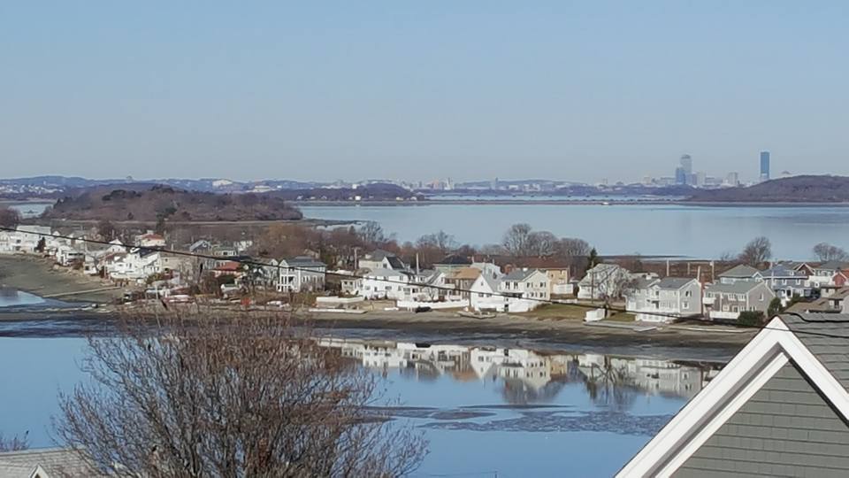
Hull, courtesy of Nathan McKelvey
We'll be talking Irish Riviera today, to get your mind all proper-like as St. Patrick's Day draws near. We shall explore what a Riviera is, why we have so many Irish, how so many of them ended up on the South Shore and whatever else comes into my head as I bang away at Ol' Momma Keyboard here.
Let's start by discussing what a Riviera is. The famous one is the French Riviera/Cote d'Azur, which is France's coastline on the Mediterranean Sea.
The Cote d'Azur is a resort area. You know how they say that the French all take August off? This is where they go. British, continental and even Russian tourists also started arriving in droves. A 1763 British author wrote of the benefits of oceanfront vacations, and by the end of the 19th century, it was the thing to do.
Originally an aristocracy thing, this newfound (coastal people were generally thought of as a sort of salty hillbilly for much of history) love of seaside resort life soon spread down to the proles.
In the United Kingdom, factories would often close for a week or two in the summer to service and repair the machines. This would loose the workers upon whatever resort areas they could afford to get to. They frequently chose the seaside... maybe get a cottage on the Isle of Wight, if it's not too dear.
This love of seaside resorts definitely bled down to the Irish. Pale and hard-drinking, they were the perfect candidates for the brief two-month-summers of Massachusetts beach life. They just didn't figure it out until they got to America.
Marshfield, thanks to Annaliese Sviokla!
The Irish love America, and the 33 million of them here today equal about 10.5% of the US population. There are more Irish in America than there are Irish in Ireland.
As you probably guessed, most of America's Irish live in California, followed by places like Texas, Florida and Ohio. However, those are just population numbers. When you get to the leaders by % of Population as Irish, your leaders are New York, Pennsylvania and Massachusetts.
Massachusetts takes the title via a robust 21.2% hit of Irish in their population. That's about double the US average. Six of the top ten Irish towns in America are in Massachusetts, and we dominate the top 20, top 30 and top 100 as well.
Milton, MA 38%
Pearl River, NY 38%
Braintree, MA 36%
Collingdale, PA 35%
Marshfield, MA 35%
Scituate, MA 35%
Gloucester City, NJ 34%
Drexel Hill, PA 34%
Pembroke, MA 34%
Weymouth, MA 33%
The numbers are sometimes in dispute, and it depends on who you ask and what your terms are.
I'm pretty sure that she's English, but she's posed well
Fieldston (Marshfield) and Squantum (Quincy) sort of trade the title back and forth for Most Irish Neighborhood. Squantum is about 65% Irish, but the difference between Squantum and Fieldston is small enough that the birth of a set of twins or a multiple casualty incident on a road outside of a pub may tip the balance one way or the other.
Most of these Irish started off in Boston. Catholicism was prohibited by the Puritans in Massachusetts, so the Irish were either not coming or pretending to be Scots for a lot of our history.
In the 1820s, various projects like canals, roads and railroads needed cheap labor. Irish immigration skyrocketed. The Great Hunger, where a blight killed off the potatoes which the Irish had come to depend on disproportionately, scattered the Irish like a sort of Mick Pinata.
Two million Irish arrived between 1820 and the US Civil War. They were attracted to cities, where Irish communities were springing up. They were also popular (at least as labor) in any town with a mill. The influx was only slowed by the Great Depression.
My favorite anti-Irish quote, used completely out of context here... "You will scarcely ever find an Irishman dabbling in counterfeit money, or breaking into houses, or swindling; but if there is any fighting to be done, he is very apt to have a hand in it."
Boston had 35,000 Irish (about 25% of her total population) by 1850. They have banged out 3-7 kids per family ever since. They also got scattered around, as the Irish tend to do.
S'up, girls?
How did the South Shore get so Irish? Were there mills all over Marshfield and Pembroke? When did the Eyes start arriving?
Yes, we did have some mills. There were even fringe industries that attracted Irish, like Irish Mossing in Scituate. Those features brought a lot of Green to SE Massachusetts. You'd also have Irish workers who had earned enough to get out of the city, looking for a more pastoral lifestyle. This was especially true of retiring Boston cops.
After WWII, and with the prosperity following it, many Irish returning from war took the opportunity to head for the sticks. The highway system (especially Route 3, which should probably have an Irish nickname like Mick Street or Paddy Road) provided access to what was already being called the Irish Riviera.
There was yet another Irish Diaspora that grew from the busing era. Any moneyed Mick got the heck out of Dodge when the city started getting ugly. Every town on the South Shore saw their population just about double.
Think I'm lying? Here are the population figures for both 1960 and 1980 for a few South Shore towns, and I could have drawn names from a hat in this region without screwing up my statistical model that much:
Plymouth, 14K to 35K
Duxbury, 4K to 11 K
Marshfield, 6K to 21K
Scituate, 11K to 17K (Scituate reached their Paddy allotment earlier, with the Irish Moss industry)
I'm not saying that the onus of busing involved poor Irish neighborhoods, but you didn't see a lot of people fleeing Wellesley. The South Shore filled with Irish-Am families from Dorchester, South Boston, Charlestown, Hyde Park and so forth. I spent at least one summer as a Dorchester kid living on Duxbury Beach, dating a Boston Latin girl from West Roxbury who summered in Green Harbor. That's straight-up Irish Riviera living, player.
With many South Shore immigrants from Boston, it was just a case where buying and building up a South Shore cottage was cheaper than sending your Irish brood (save the venom, your author is as Irish as a puddle of Guinness vomit outside of Triple O's pub) of 5 kids to private schools from K-12.
Throw in a cycle or two of reproduction, and we are where we stand today.
There is some dispute as to the borders of the Irish Riviera.
New York (Rockaway Beach), Indiana, Michigan and New Jersey all have areas known as the Irish Riviera. However, once you start counting Paddys, Massachusetts can tell all of the other states to start thinking of a new nickname.
The Irish Riviera is generally considered to be the coastal South Shore. Many use a sort of river/tributary system based on Route 3 or especially Route 3A.
Some people include the whole South Shore, as interior towns like Whitman and Pembroke also sport large Mick populations.
Some go the other way, using a Scituate/Marshfield definition. Other people stretch it on to the Cape, to the Kennedy Compound. You still have heavy Irish numbers on Cape Cod, but you should also notice that those % of Irish in a town charts I put up earlier don't have Sandwich, Orleans or Hyannis in them.
I'd personally run the Irish Riviera from Quincy to Sagamore, after which the Cape starts importing tourists and summer people of every stripe to f*ck up the numericals. Bourne is the first town in a long run of coastal Massachusetts towns that doesn't make it onto those % of Irish in population charts, although they are most likely in the 25-35% (Editor's Note: 27%) range.
Besides, the Cape Cod Canal makes for an excellent natural border.
Will the Irish Riviera ever lose her unique, Irish domination of the population base?
There is some gentrification going on. Those cottages that were owned by Irish families for so long get sold now and then. Many of these people are Yuppies, looking to flip a cottage into a coastal McMansion. The Irish make for poor Yuppies.
Many of the Branns and Egans and Carrolls (and even the also-Catholic Italian families like the Leones and Palmieris) from my old neighborhood are still holding out, although the veteran Brann that I spoke to tells me that the neighborhood just ain't the same. The Kerrigans scattered across the world, from Plymouth to Florida to Arizona to San Diego to Australia. Even that Bowden kid is shacked up with a French girl on Cape Cod.
However, it would take some Third World birth rates from other nationalities to knock, say, Scituate down from 35-45% Irish. Since the Catholics frown on birth control, they may even crank out 5 kid families for generations to come. People will still flee Boston. Irish families that grew up summering on the Riviera will move there full-time.
Other Irish families buy up neighboring Riviera houses as the kids marry off, and build little compounds. There is one corner of my old Duxbury Beach neighborhood where you could knock on 3 different doors and still get a Deehan, and tiny Ocean Road North once, in 1999, had 6 houses owned by descendants of the same branch of the Flaherty family.
In the end, we'll end up with a thinned-out-but-still-vital Irish Riviera. You won't beat the Mick out of this area for several generations, if ever.


 The low-income area around the Cape Cod mall is notorious for violence.
 PAVE PAWS is a United States Air Force Space Command radar system operated by Space Wing squadrons for missile warning and space surveillance.... and I pasted that right from Wikipedia, so go to them if you disagree.