Hurricane season is upon us, and we are nearing the peak of it.
Now, we're in Massachusetts, and we haven't been hit dead-on by a hurricane since the 1990s. That means that we don't get them often, and it means that we are long overdue.
They aren't a frequent enough event that you should walk around wringing your hands or anything. However, there are certain things that a wise person might do which can eliminate a lot of the hand-wringing.
Ironically, the first step to a peaceful mind is to view some Disaster Porn!
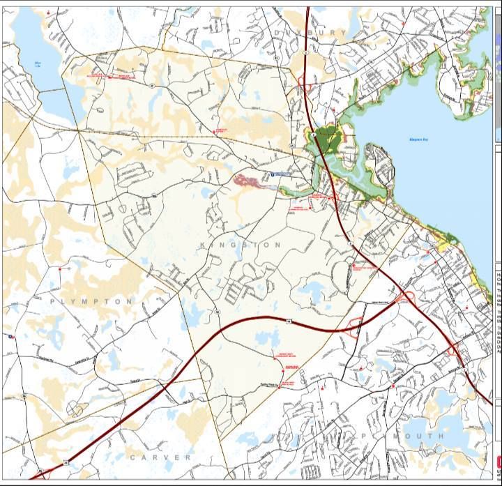
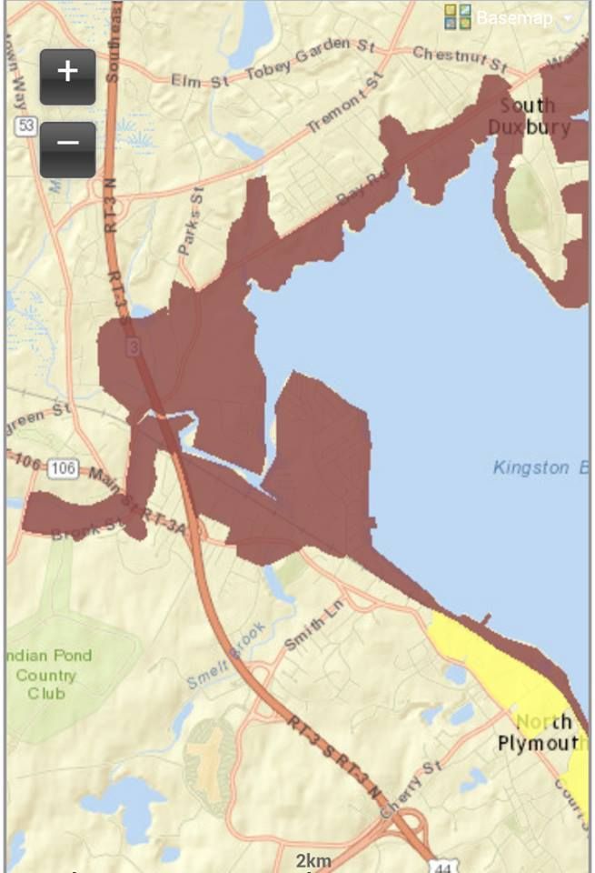
We have two maps for you to look at, and they are specific to your town. One is for Inundation, and the other is for Evacuation. They pertain to a direct-hit hurricane hitting your town at mean high tide.
"Inundation" means "covered in water," although you can call it a Deathflood or a Sea Plague if that gets your people motivated. It refers to which areas in town will be covered with seawater (important distinction, these maps do NOT project freshwater flooding) if you play host to a hurricane.
The map for Inundation (the top one) is color-coded, with light green, dark green, yellow and red. Those colors equate to which areas will get wet in what kind of storm, i.e. Category 1, 2, 3 and 4. Where you see colors changing on the map, that's where the experts think it will require a greater storm to flood that area in seawater.
The map for Evacuation (right) is less complicated. If you look at the Inundation map for a moment and then look at the Evacuation map, the logic will eventually make sense. The red areas of the map essentially say "Those People Have To Leave," and the yellow areas say "You Have To Leave, Too."
See how you compare to your neighboring towns with the complete list of Inundation maps and Evacuation maps.
Remember, storm surge is not the only threat from a hurricane. Things like falling branches, freshwater flooding, lightning, flying debris, slick roads, tornadoes, downed power lines, looters and a thousand other variables can mess you up plenty when the barometer drops heavy.
Kingston is somewhat shielded from the worst effects of a hurricane by several factors.
1) Any hurricane that hits Kingston is going to have made landfall somewhat south of Kingston, either on the South Coast or on Cape Cod. That will weaken it, and The Town Of Kings wont get any of that Hurricane Bob damage unless the storm is a true behemoth.
2) Another benefit that Kingston enjoys is the double wall of barrier beaches provided by Duxbury Beach and Long Beach in Plymouth. Throw in the even larger barrier beaches for Kingston that are the South Coast, the Upper Cape and the Outer Cape, and Kingston is (relatively) catching softballs.
3) Kingston Bay is shallow, which is sort of offset by the fact that some coastal areas of Kingston are low-lying.
4) Other than the head of the bay (which is also where a river empties, no small consideration in a storm where 6-12 inches of rain could be falling), a lot of the Kingston coast is in no great danger other than directly at the coast.
5) A lot of the area in Kingston that will flood is undeveloped.
6) Water is only predicted to make it deeper ashore (Jones River flooded with ocean water out to Route 106) in a Category 4 hurricane, which hasn't hit New England since the Paleface Man arrived.
This doesn't get K off the hook, though. Kingston has suffered storm damage in the past, and the future promises even more.
The jackpot areas seem to be Jones River Beach, the direct shores of Rocky Nook, Gray's Beach and especially Bay Farm. Bay Farm will take the most flooding, but it also has the least development.
In short, Kingston probably won't be Ground Zero for some Katrina-style event. You might be in the news story, but you'll be in the small print unless a school gets leveled. Still, you want to memorize this information and base a plan around it. We need you alive to provide site visits for us.

No comments:
Post a Comment