 |
| "It's so cold in the D..." |
Our continuing series on hurricane safety takes us today to the lovely town of Dartmouth.
Dartmouth is very large for a small town. They have 34,000 people, although that number is skewered by college students and summer people. Only a few, like God, Santa, and the fire chief, truly know how many people are in Dartmouth at any given moment. Only Plymouth and Middleboro have more land.
Dartmouth itself is divided between two general areas- North and South Dartmouth- and those two areas are divided into five villages or so. Once you get into the nuances and differences between Hixville (should really be more rural), Bliss Corner (should be nowhere but wherever UMD girls go to strip), and Padanaram (which sounds like a Euro death metal band name or perhaps even a level of Hell, but is actually a gorgeous, affluent area), ol' Steve taps out and admits that he's from Duxbury Beach.
Shoot, we're just hyper-analyzing aerial maps, and you really don't want to finalize your plans unless you wield great local knowledge (by "great," I mean "has been through several major storms in your area") or have spoken at length with a neighborhood old-timer. Locals know lots of stuff that pros don't, extra-especially neighborhood specific stuff. I'm just a NWS spotter with a web site, your neighborhood has old people who know more than I do, merely by experience.
But I am good for something, and that something is providing you with maps that contain important hurricane information that is specific to Dartmouth. You can review these maps right down to your very house, which is why I'm so cavalier when writing about towns I don't live in. Anything I don't know, you can figure out yourself by zooming in.
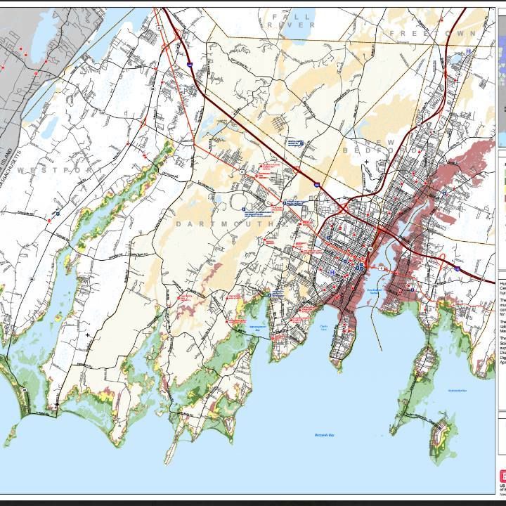
The map at the top of the page is a Hurricane Inundation map, and it basically tells you where the ocean will flood in a direct-hit hurricane striking at mean high tide. It is color-coded, with the colors showing the minimal storm intensity level (Saffir-Simpson hurricane scale, i.e. Category 1-5) that would flood a particular area.
Light green = Category 1... Hurricane Belle or Gloria were Category 1 affairs. If you washashored into Dartmouth from the South Shore, the Halloween Gale would be a good, strong Cat. 1.
Darker green = Category 2... Hurricane Bob was a strong 2, maybe a mild 3. Yes, I know that "mild" is a strange term to use before "Category 3 hurricane," but that's how we roll here in Cranberry County.
Yellow = Category 3.... you're talking historic doom here. Only 5 storms of this power have hit New England. You most likely know someone who was here for Donna (1960) and may even find a geezer who was around for The Great New England Hurricane (aka The Long Island Express, 1938). You want to talk to these people before they die, and vampire their wisdom for yourself.
Red = Category 4... You don't have to worry about this one, because if anything of this Katrina-level power is heading your way, you should be ghost... all the way to a Vermont hotel.
"Flesh" = 100 year storm, which should be a 500 year storm, seeing as we've had 500 years pass without one. I don't know what color to use for that, I went with the Crayola 1973 color name that came to mind. Call it "apricot" or even "off-whitey" if you like.
Pretty-please take note that this map is for seawater inundation, and does not include freshwater events like river flooding, sewer overflow, and heavy rainfall. You could drown 15 miles inland if the dice come up snake-eyes during a hurricane, and your surviving family would be wrong if they blamed Mother Ocean for it.
Dartmouth offers 31 flavors of Doom in a hurricane, and you could get your wig split by falling branches, lightning strikes, downed power lines, looters, sinkholes, sharknadoes, the National Guard, and divine retribution. We're just going to focus on seawater inundation and evacuation.
Speaking of evacuation...
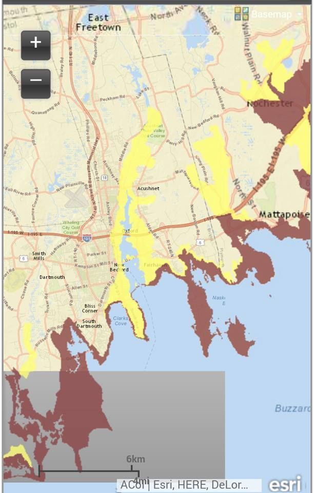 |
| Cell-phone map, player... the one in the links is better. |
This map is easier to read. It has two levels of severity. Red means "these people have to go," and Yellow means "you also have to go."
I apologize for the scale. I'll throw some links at the end of the article for people who want to zoom in on Russells Mills or Pandemonium or wherever.
As you can see, 99.9% of the town will not require evacuation. However, many heads can be found in those colored areas (in this scenario, the rich white people with waterfront homes are the colored ones), and they should think about galloping the fudge out of town. A hurricane that is sizing up Dartmouth will be flying up at her unimpeded, and the collision will be historic.
Even if you live in a white neighborhood in the inundation map, you should consider fleeing. New England does not lack for trees, and it only takes one to make you a homeless person with a yard full of live, downed wires. It can be tough to get to/into a shelter once you realize that you'll need one.
Likewise, these evacuation zones are what the police will be working with in their storm planning. You don't HAVE to leave if the evacuation order is given, but you don't want to be relying on the 5-0 guy you read the Constitution to before the storm being the one who has to pull you out of the maelstrom once Mother Nature starts playing for blood.
Notice that Route 195 will be underwater in some spots during minor hurricanes, and will be a series of islands in a larger one. They kinda cut that ish close to the coast, especially in Nastypoisett.
Anyhow, that's the storm information I have. Learn it, know it, live it. I want you alive. My revenue stream is such that I can't afford to have any of my readers perish. I also have a soft sport for Dartmouth... UMD was one of the few schools to accept your author when he came out of high school. I got nothing but love for you. "I advocate hanging on as long as possible..."
Hurricane Inundation Zone maps... from FEMA, MEMA, NWS, and NHC.... and ME. Zoom in on your neighborhood. Do some disaster porn! Speculate on the fate of people in other towns who you hate! Hours of weather-geeking fun!
Evacuaton Zone maps... make sure you don't evacuate into an area that is colored more harshly than yours, people.