|
| Time and Tide wait for no man, and the feeling is mutual. |
Beaches are not permanent things. Waves, wind and rain erode beaches, and shifting sands go where they may. It's how the world works, and how it worked for a long, long time before man arrived and started building along the coasts.
This natural order of things is all good, as long as you don't mind the fact that Monument Beach may become Monument Harbor some day. Oceans have a way of asserting themselves, and care little for these maps that men draw.
Of course, this natural order of things sometimes gets in the way of important things like Waterfront Development and Beach Access, which is where we'll be going in today's column.
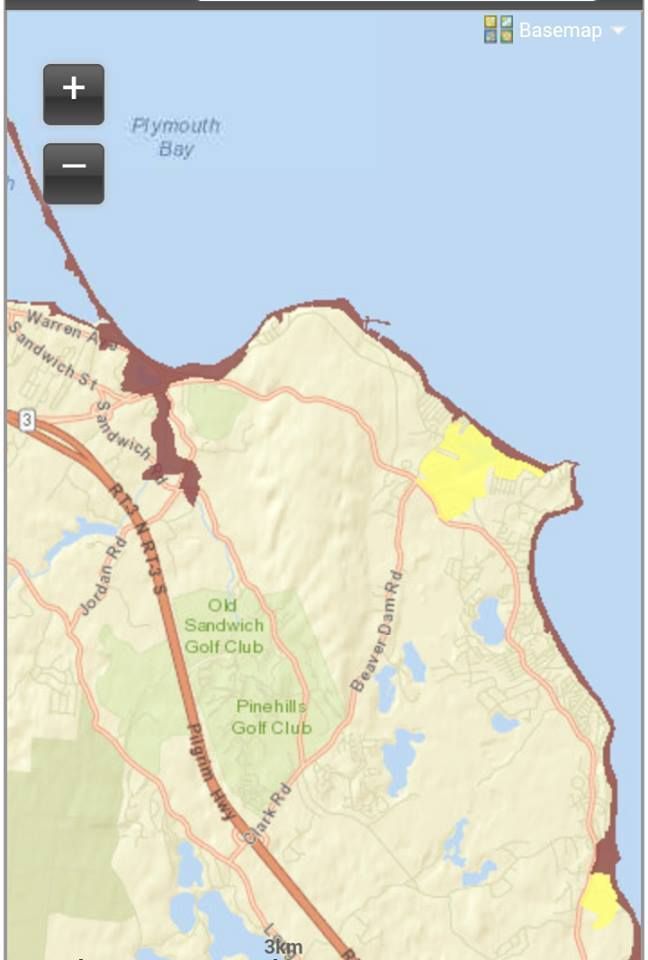
You're looking at Cedarville, which is a better-sounding name than the more fitting "Wicked Big Dune." Cedarville is where you end up if you walk North out of Sagamore Beach. Their coastline is defined by giant, fragile sand cliffs.

Sand cliffs are very vulnerable to erosion, especially if they have no vegetation. You can pretty much see how it works just looking at the picture above. Rain and gravity move the sand from top to bottom, and the ocean washes the sand down the beach.
Much of the Massachusetts coastline is built that way. Scituate also has sand cliffs, and the erosion of these cliffs nourishes beaches south of Scituate in Marshfield and Duxbury. Saquish and her sand cliffs replenish beach sand in northern Plymouth, while sand cliffs in Manomet handle southern Plymouth.
Cedarville's job is to hook up Sagamore Beach, Scusset Beach, and Town Neck Beach. Cedarville's sand cliffs meet up with Sagamore Beach's sand cliffs, as you can see in the picture below. The flow of sand tends to be, as directed by the ocean's forces, north to south. The coastline south of this picture depends on these cliffs for their sand, lest the (present) coastline gradually erode away.
Sagamore Highlands has their own seawall battle going, and we'll write about that in a few days. I felt that you needed to know about the Dune Tram (see the video at the end of the article) more immediately.

Shifting sands are all well and good, unless you own a little cottage on top of those sand dunes.
Very few people say "Hmmmm.... I think I'll build my house directly on the lip of this 150 foot free fall." However, they didn't understand how Erosion works, or they underestimated how quickly it happens in the great scheme of things. That's how you get a house with Potential Energy that very much resembles a cottage version of Lindsey Vonn about to bust out of the gate and ski downhill.
Maybe the builders knew about erosion, but counted on it not being a problem in their lifetimes. I always think of Henry Beston when pondering this. His famous "Outermost House" was eventually pulled into the sea in the Blizzard of '78, but I assume that Henry Beston was long dead when that happened. Whatever design and location flaws the Outermost House may have had, it lasted long enough for him.

To avoid a Bestoning of your beach house, you need to put in some work. This generally involves building a seawall. A thick concrete wall running miles along the coast is more of a job for the US Army Corps of Engineers than one for a scrappy homeowner, but other options are available.... and necessary, as the US and Massachusetts governments seem to have given up on Cedarville.
In fact, looking at those cliffs, the government would have to build one of those 20 story World War Z-style Jerusalem walls, which would be a pretty expensive and exclusive job considering that it would benefit about 10-30 homes. Cedarville residents are on their own.
The home in the pictures above and below went for the Lobster Pot approach. The homeowner wraps scores of stones in metal netting, and uses it to build a base at the bottom of his cliff. The netting keeps the stones from being washed away one at a time in large storms. The stones, in theory, keep the cliff from washing away.
It works better if your next-door neighbor builds one as well, but you can't win 'em all, folks.
Here's a close-up.

There's a Rock Lobster joke lurking in the picture above, but even I won't hack away at that level.
You can also use this sort of pantyhose-style sand condom thing that the guy in the picture below favors. He looks like he may need to make it a bit higher, but what do I know?
I do wonder if there are laws against using beach sand for that purpose. I don't want to hassle the homeowner, as he has enough problems. I suppose that he may even be helping the beach, or at least the cliff.
I just think it's funny that a guy who lives on a giant sand dune which overlooks a sandy beach might have to import sand.

Keeping the sand from washing downhill is just part of the problem. You also have to keep it from washing downstream, or whatever you call "downstream" with oceans.
This is where the Groin comes in. Yes, it's a silly name, one which the actual English English-speakers get around by using the more Olde English-looking groyne.
As near as I can tell (and I'm working from Word with no Internet connection, so we're doing very little research), the difference between a groyne and a jetty is that a jetty is at least partially in the water all the time, ideally to protect a channel or harbor entrance. A groyne is there to keep your sand from becoming Sagamore Beach's sand, and is mostly on land at low tide.
While they are more angry at the Scusset Beach jetty that is the north end of the Cape Cod Canal, this groyne is one of the things that the Trustees Of Sandwich Beaches people are all upset about. Every grain of sand that the groyne prevents from moving south is a little bit of Sandwich eroding into the sea, kinda/sorta. If you are ever driving on Route 6A in the future and a wave washes under your car, you're going to have to learn some Olde English if you want to place the blame properly.
This groyne is on the beach in front of (and preserving) the 18th Hole on the golf course at the White Cliffs Country Club. The hole is on top of a dune, as they haven't invented Beach Golf yet. The groyne was built in 2008, after some legal wrangling. WCCC would be a 17 hole golf course in a few years if they didn't have several groynes.

WCCC is one of my chill spots, as they have a lovely little private beach that, because of the 175 foot dunes, very few people use. They are taking steps to fix that, as many of their tenants and members are elderly.
Below, peep the photos and video of the brand spankin' new Dune Tram.
We were talking to a guy who bought one of the first units made available at White Cliffs, back in 1986. One of the reasons he bought the place was that the WCCC was promising a Tram to the beach. 28 years later (sounds like a Zombie film sequel, no?), WCCC finally came correct.
They utilized a firm called Marine Systems Incorporated (from friggin' Minnesota, of all places) to design the Tram, which was built by a Massachusetts-licensed elevator company called Above & Beyond. The tram operator had no cost figures when I asked her (and I have no intention of wasting a late summer morning attending the WCCC Tram Media Day tomorrow), but the cost I kept hearing for the Tram was six figures.
The Tram is the only one of her kind in New England, at least to my knowledge.
 |
| Like you even have to ask if we tested it out..... |
It's the size of an industrial elevator, which I suppose is a good thing, because it is an industrial elevator. It is sort of set up like a ski lift, but you stand in an elevator car. It goes about one mile an hour or so. You'd beat it to the beach if you were walking downhill, and it would beat you to the crest if you were walking uphill.
The Tram runs 175 feet, and it is just what you want to see coming for you when Option B is walking up 15 stories worth of stairs after a long, arduous day of Beach. I'm told that the poles were hammered 25 feet deep into the dune. The ride is very smooth.
Added bonus? It's elevated, so vegetation can still grow in her footprint. The Tram is only a month old, and there's already some Beach Fuzz growing under it.
There is an attendant who runs the Tram, and a position of "Tram Operator" was being advertised for on the WCCC website. I may take that job myself next summer. No, they don't play elevator music.
However, "Dune Tram To The Groin" would make a good Dancehall song title... but they'd have to go to a coastal country club in Plymouth to film the video, and that would cost them a breathtaking amount of street credibility.

Check out the...
Dune Tram video.
You know you want one of these Dune Trams, so stop acting like you don't. You aren't fooling anyone.