Showing posts with label Kingston. Show all posts

Monday, October 26, 2015

Halloween Displays Around SE Massachusetts: Part One

We had a fairly good series of thoughts the other day.

- We should do a Halloween Display article.
- Very few singular people can give a list of 250 or so houses with cool displays (I am now one of these people).
- Why not use Facebook (I spam our articles over every You Know You're From ____ When... page in the region, and have access to scores of such groups) to get a good list going?
- Gather up the suggestions (we had a few hundred) and start mapping routes for several road trips.
- Spill our results out over a series of pre-Halloween articles.

We rarely start off with that much of a game plan, so this will probably end up working out OK.


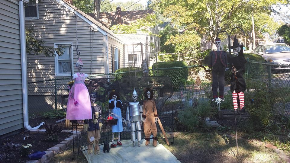
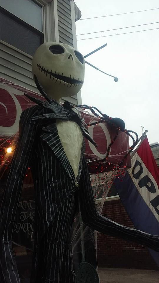
We got a bevy of suggestions for where to look. We ranged from Plymouth (the Slenderman-looking Tim Burton guy at the top of the article) to the skeletal Wizard of Oz scene we saw in Weymouth, to wherever else our travels took us.

Facebook was very handy. We got a pile of street names. Some got repeated, always a good sign. I'm still getting suggestions as I write this, but fear not- we have enough pictures for several days of articles on this subject.

We got a few bum steers (we had several in a row on our first run), but we also stumbled onto some cool stuff, so it sort of balanced out. I'm not into Wicca, but I think they're big on Mother Earth and all, and nature loves a balance. My own logic is witchy enough that we went home happy most of the time.


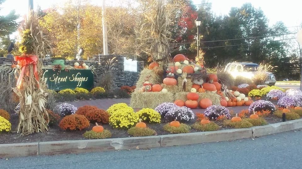
Rich people plaza.... nice setup, though. It needs a Zombie, right in that empty spot near the hay bales.

We drove down a lot of Massachusetts streets doing this series of articles. Some towns stood out more than others, but not by a wide margin (editor's note: we haven't done Deluxebury yet) Most people don't decorate at all. Among those that do, most are subtle. A pumpkin, a scarecrow, a few cornstalks... you know, the regular.

We set out to find people who went in a little deeper. I'm talkin' ten-foot-spider-swallowing-a-human-in-front-of-a-two-hundred-sixty-one-year-old-historical-register-property deep.


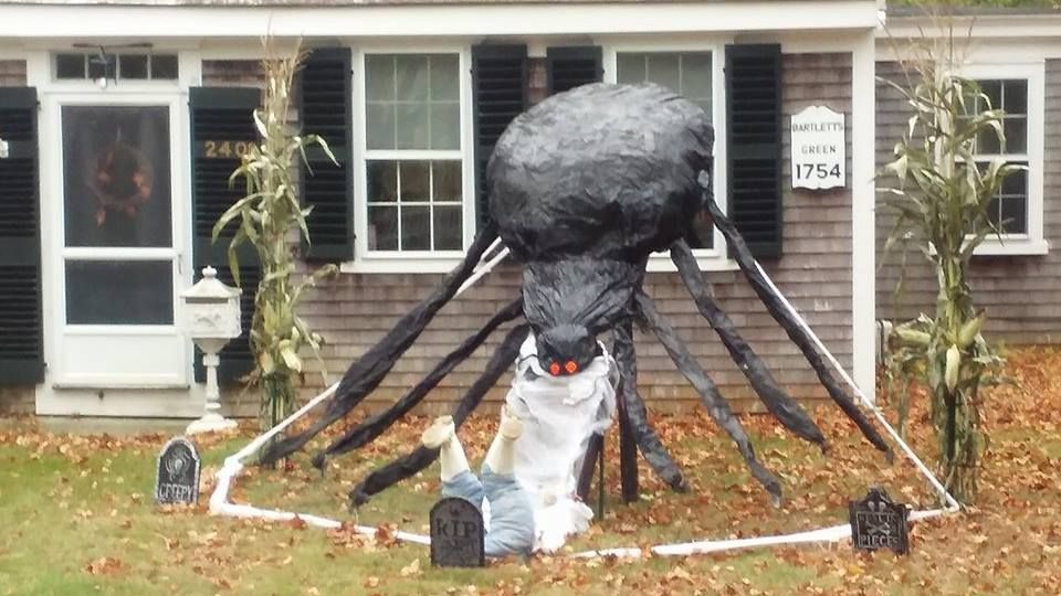
Apparently, things get a little more ultraviolent on Bartlett's Green than I was previously led to believe.

The spider also looks like hes doing the Baby Bird with some poor intern, but that was most likely not the intent of the sculptor.

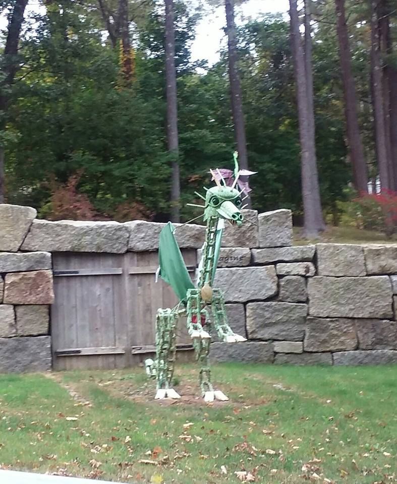
That spider, a Kingston resident, doesn't dare try that act in Duxbury. If he did, he'd get tuned up by Duxbury's legendary Green Dragon. The GD holds it down off Route 3A in Duxbury. There are those who say that he stares into your soul as you drive by him.

The Green Dragon does year-round duty, but he gets extra powers on Halloween. If you ever look up at the nearby Myles Standish monument and wonder where his sword went.... well, it got busted off quick-fast when Myles tried that St. George stuff with the Route 3A Dragon. You know... back in the day.

Kids dress in all sorts of costumes. They sometimes favor horror (my kid had to be carefully edged away from Creepypasta-themed costumes), but they sometimes go out as a Princess or a Cowboy or an Astronaut. Its not always horror, although it was for most of the history of the activity.

However, people who decorate their lawns almost always go for Horror. I checked out almost every town, including yours. I saw a lot of chainsaw massacres and MacBeth-ian witch gatherings, but I rarely saw innocent Haloween decorations. I can think of one, a Peanuts-themed setup in Halifax that I'll get to in another article.


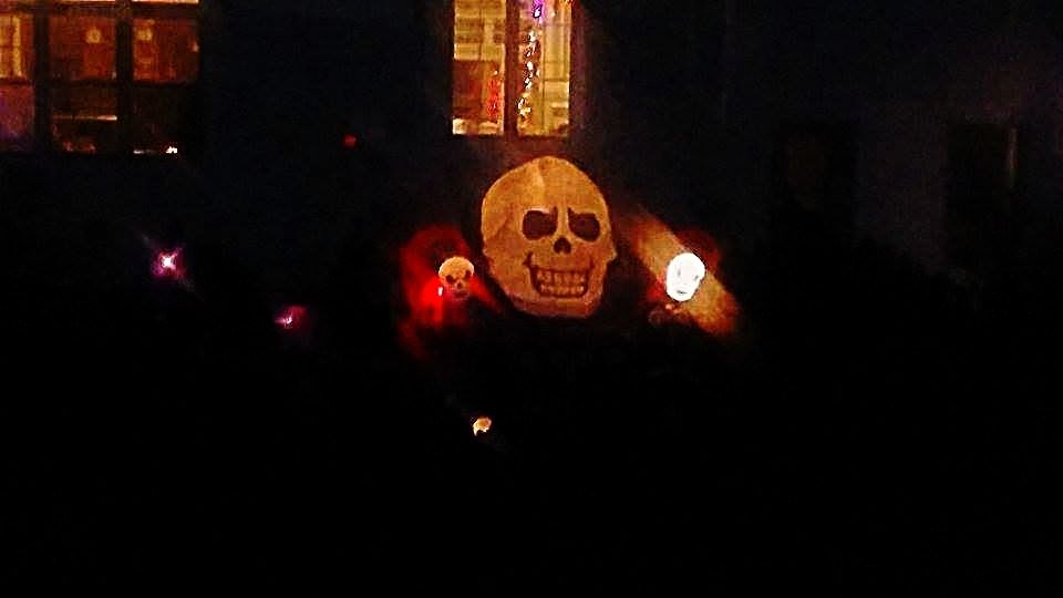
We'll throw in the obligatory warning that I am a much worse photographer than Jessica is. As you see below, we also have some trouble shooting at night.

I may take another crack at this shot above, It's off Herring Pond Road in Plymouth, and I pass it all the time. Even a hack photographer will get lucky if Stephen he shoots enough.

Our principal value to you is our legs. We covered a lot of ground doing this article, and we aren't done yet.

We'll try to drop an article a day up until Halloween hits. If your town got jobbed this time, fear not. We'll probably get to it in a few days.


Stay Spooky!

Thursday, October 22, 2015

South Shore Foliage, 10/21/15

We rolled out with monster truck force all over the South Shore's interior as we tracked down the places that have already turned over. This is East Monponsett Lake, in Halifax.


This part of Massachusetts (Plympton, Route 106) gets some cool foliage. It just tends to be worked into the proverbial Sea Of Green. No, I have no idea why one tree is orange and every other one is green, that's between you and Mother Nature. I just click the camera and write the captions, friend.


You don't get those Vermont calendar pictures in Duxbury. I have no mountains to look down from, and too many pine trees. At times, I'm reduced to shooting at branches on a single tree.

We were gonna shoot video, but..well, trees don't really do that much. We were ready to turn the video on if a Sasquatch walked out of a South Halifax forest.

Kingston got some licks in, especially in the Jones River Reservoir area off Route 80. We started in Duxbury, then went into Kingston. We essentially flipped a coin as to left or right onto Rout 80, we went right and found this about 100 yards later.


If you take your glasses off, it looks like a tree fire. I should have rolled a smoke bomb under that, or maybe even exhaled a fat hit into the picture just before I clicked.


We got a cloudy day for Rural Exploration, but there was no wind, so we got some sweet lake-reflection shots.


We have mobile photography capabilities, they even come out sometimes.


With Monponsett Lake(s), we're in there like swimwear.
We're just warming up, so we have plenty of more work to do. We may still expand our reach up into the Athol/Ashburnham corridor, they're peaking right now.

We will also be all over the South Coast, South Shore, and Cape Cod. You know were good like that.


Tuesday, August 4, 2015

Kingston Hurricane Primer: Inundation And Evacuation


Hurricane season is upon us, and we are nearing the peak of it.

Now, we're in Massachusetts, and we haven't been hit dead-on by a hurricane since the 1990s. That means that we don't get them often, and it means that we are long overdue.

They aren't a frequent enough event that you should walk around wringing your hands or anything. However, there are certain things that a wise person might do which can eliminate a lot of the hand-wringing.

Ironically, the first step to a peaceful mind is to view some Disaster Porn!

We have two maps for you to look at, and they are specific to your town. One is for Inundation, and the other is for Evacuation. They pertain to a direct-hit hurricane hitting your town at mean high tide.

"Inundation" means "covered in water," although you can call it a Deathflood or a Sea Plague if that gets your people motivated. It refers to which areas in town will be covered with seawater (important distinction, these maps do NOT project freshwater flooding) if you play host to a hurricane. 

The map for Inundation (the top one) is color-coded, with light green, dark green, yellow and red. Those colors equate to which areas will get wet in what kind of storm, i.e. Category 1, 2, 3 and 4. Where you see colors changing on the map, that's where the experts think it will require a greater storm to flood that area in seawater.

The map for Evacuation (right) is less complicated. If you look at the Inundation map for a moment and then look at the Evacuation map, the logic will eventually make sense. The red areas of the map essentially say "Those People Have To Leave," and the yellow areas say "You Have To Leave, Too."

See how you compare to your neighboring towns with the complete list of Inundation maps and Evacuation maps.

Remember, storm surge is not the only threat from a hurricane. Things like falling branches, freshwater flooding, lightning, flying debris, slick roads, tornadoes, downed power lines, looters and a thousand other variables can mess you up plenty when the barometer drops heavy.

Kingston is somewhat shielded from the worst effects of a hurricane by several factors.

1) Any hurricane that hits Kingston is going to have made landfall somewhat south of Kingston, either on the South Coast or on Cape Cod. That will weaken it, and The Town Of Kings wont get any of that Hurricane Bob damage unless the storm is a true behemoth.

2) Another benefit that Kingston enjoys is the double wall of barrier beaches provided by Duxbury Beach and Long Beach in Plymouth. Throw in the even larger barrier beaches for Kingston that are the South Coast, the Upper Cape and the Outer Cape, and Kingston is (relatively) catching softballs.

3) Kingston Bay is shallow, which is sort of offset by the fact that some coastal areas of Kingston are low-lying.

4) Other than the head of the bay (which is also where a river empties, no small consideration in a storm where 6-12 inches of rain could be falling), a lot of the Kingston coast is in no great danger other than directly at the coast.

5) A lot of the area in Kingston that will flood is undeveloped.

6) Water is only predicted to make it deeper ashore (Jones River flooded with ocean water out to Route 106) in a Category 4 hurricane, which hasn't hit New England since the Paleface Man arrived.

This doesn't get K off the hook, though. Kingston has suffered storm damage in the past, and the future promises even more.

The jackpot areas seem to be Jones River Beach, the direct shores of Rocky Nook, Gray's Beach and especially Bay Farm. Bay Farm will take the most flooding, but it also has the least development. 

In short, Kingston probably won't be Ground Zero for some Katrina-style event. You might be in the news story, but you'll be in the small print unless a school gets leveled. Still, you want to memorize this information and base a plan around it. We need you alive to provide site visits for us.