 |
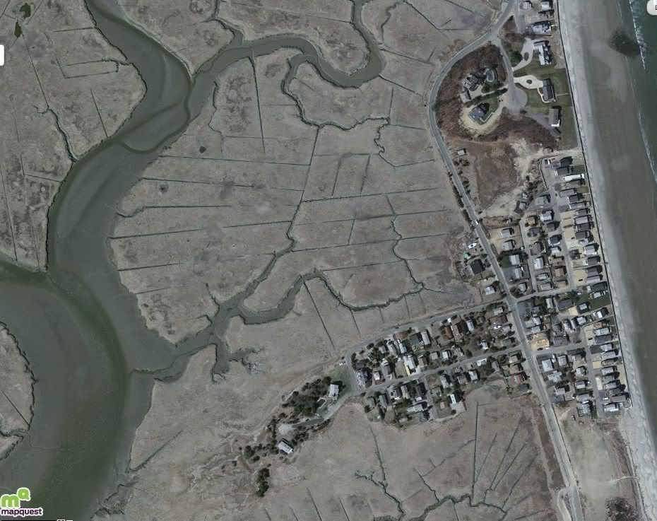
| The Great Salt Marsh, east of the Cut River, Duxbury MA |
At some point, even the anti-geekiest of us is going to get on those Internets and Google Map their neighborhood. God's view of anything is fun to have, or even that of a high-flying bird or low-flying airplane. You get to view humans as you normally view bugs, making sense of terms like Alien Ant Farm and so forth. Taking a funny view of atheism for a tangent, views like this would be given as proof if God and Allah were arguing over whether humans exist.
We all geek it up for different reasons. My sister has seen this picture, which actually has a lot more ocean in it if you zoom back some. She owns property there, and her first thoughts on seeing the picture were of how vulnerable the coastline is against the sea. It's really only a thin strip of land, and it goes totally underwater every few storms.
A military-minded friend of mine named the Colonel was shown the same pic, and commented on how Cable Hill would be the key to defending the region against an amphibious assault. A nightclub owning friend of mine marvels over the ease of which The Coolest Bar In Massachusetts could be constructed there. A realtor I know said that she "could get $750k for a single-hole outhouse" in that region, which made me feel badly because my current house in/on Buzzards Bay isn't much more than a single-hole outhouse. I only dropped $135K on it.
My own thoughts, upon zooming in enough, were that there is no name for the little river that breaks off the Cut River and runs alongside Marginal Road, and that I should look into having it named "the Steve River" if I ever wield enough influence. I have a tendency to Think Big, which my shrink tells me is proof of my delusions of grandeur and why I should take those pills she gives me. F*ck her.
Another friend of mine- who is a bit crazier than me, to the point where she sold her house and moved into the woods prior to the didn't-happen 2012 Planet X pole shift- put her focus on a different aspect of the photograph, and that is what we'll discuss today.
There are a series of grid-like cuts made in the marsh, all over it, visible from space if Space zoomed in a lot. They are obviously man-made... or maybe not so obviously.
She thought it was Alien Writing, a big caption on this part of the planet that spoke an unknowable message. It was a fun conversation, trying to guess what they'd be marking off here.... "Mostly Harmless," "Irish Riviera," "Take Off Wrapper Before Cooking," "This Space For Rent" or "My god invented this stupid universe and all I got was this lousy knoll."
The big difference between us is that she went home convinced that she was right, while I just felt a little guilty about sleeping with crazy people. Hey, the son also rises, right?
I did take an interest in those lines. You know when you get just interested enough in something to wonder about it, but not interested enough in it to ask an authority? I was that interested.
It's more fun to think up solutions without scientists and historians messing up the fun. I came up with:
- Fish Trapping Device, where they block off the channels at high tide and sweep towards the shore.
- Pilgrim or Wampanoag drainage projects.
- Duxbury Beach as Venice, maybe for cooler Wampanoags.
- Aliens with huge sticks playing Tic Tac Toe on the Earth with city-sized markings.
- Notes from God to himself for an unfinished earth-construction project, a la "Remember to put Mount Gurnet about right here."
- Great Depression busy work swamp-drainage project.
- A totally natural explanation, like burrowing horseshoe crabs or something.
- 1950s mosquito control standing-water drainage, which is actually as good an explanation as anything I have. I have people on Facebook saying they saw some of those canals being dug for skeeter control in their childhoods.
Discussing mosquito control will be tomorrow's work. They are the most likely source of the grid lines, but I actually had more fun reading about the salt hay industry.
I stumbled into Salt Marsh Hay in this article..
The marsh that stands between Duxbury Beach and Duxbury Proper is full of salt marsh hay, which I shall no longer capitalize. It is of note because salt marsh hay is much more nutritious than regular hay is. I suppose that it is because the salt marshes get all the soil runoff from rivers emptying into the estuary, which superpowers our soil there like when Barry Bonds gets into the steroids.
Basically, if you were trying to grow hay in Oklahoma or some inland state, and you brought in an army of workers and scientists to help the process along, you MIGHT grow hay as well as it pops up naturally, unaided and untended, in some Swamp Yankee salt marsh. Even then, unless you diverted the course of a few rivers and imported tons of ocean marsh mud, you wouldn't get the nutrition content of salt marsh hay.
This fact is of very little importance in 2015, as we don't take horses everywhere. It was very important in 1815, when we still did. Horses need hay, and high-powered hay makes for high-performance horses. It probably also helps cows and sheep, I have no idea. I was born in Dorchester, and Farmer Brown I am not.
Duxbury was a big shipbuilding town, and- other than the wood, of course- those shipbuilding supplies don't grow on trees. You have to ship them in, or drag them in via horse/oxen/mule. Those livestock gotta eat, and they favor hay.
Duxbury Beach was as backwater as it gets before people took up oceanfront recreation in the late 1800s. Pictures of the trans-Atlantic cable coming ashore in the 1860s show a deserted beach. Cottages didn't spring up there in any great number until the highways going South from Boston were built. Duxbury itself faded into backwater status after the shipbuilding era and before becoming a bedroom community, and Duxbury Beach was even less cosmopolitan.
Cable Hill (and perhaps the whole Duxbury Beach region, maybe or effectively) was originally known as "Rouse's Hummock," because some guy named Rouse put a farm out there. If you're the only guy who lives in an area, the locals tend to name it after you. That's how isolated it was on Duxbury Beach back in the proverbial Day.
However, the marshes provided economic activity, with reverberations that were felt throughout the whole South Shore. People got paid to harvest that hay, the hay went to horses that made money for other people, and the ships built during that era touched every corner of the
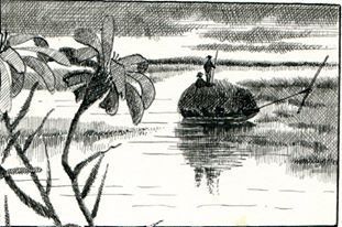 |
| A gundalow, in action... (pic courtesy of the Duxbury Rural And Historical Society) |
It looked like pretty hard work, running the hay harvest. The marsh has no trees, so you're working in direct summer sun. The light colored hay and the water around it reflect sunlight, thus increasing the heat on the workers. The horseflies are ridiculous out there, even worse than on the beaches today. You had to be out there early, as the hay had to be harvested "before the dew was dry." You were stomping through clamdigging marsh mud. You were swinging a scythe in a scene that must have looked very much like Soviet farm propaganda videos. If you sit down, the seat of your pants will be soaked in foul-smelling mud... quite literally soiled. You also had to get everything done before high tide.
They would scythe the hay down, bale it up, and then load it onto a gundalow, which is a little flat bottomed boat that is run out to larger vessels (or across the bay to the shore) for shipping. The gundalow part of the shipping was later replaced by horses and oxen. The livestock had to wear wooden shoes to keep from sinking into the marsh mud.
As for the mud flats on the beach, I have a pretty good theory. When they were digging the channels, the mud they removed would just seep back into them with the next high tide if they didn't put some sort of barrier between the salt marsh and the dumped mud. They took it over the dunes and dumped it on a then-unused and uninhabited Duxbury Beach. Out of sight, out of mind.
I'm guessing that the density of the mud held it in place, even when hurricane waves were washing over it. Other than some flattening, the mud lays where they dumped it. The little mud flats run out south of around where the bath house is today, as that is where Duxbury Bay takes over from the Great Salt Marsh.
A law passed in 1965 made it illegal to mess around even a little bit with these salt marshes. That law, designed to prevent developers from filling in marshes and making Duxbury into a Division 1 sports town, officially ended the salt marsh hay harvesting era that effectively ended in the early 1900s when cars moved horses off of the roads. The gas station became the new haystack. I'm pretty sure that the law covers the kind of activity that is necessary to harvest salt marsh hay. I'd bet that dumping mud on the beach and forming a 200 year old perma-mudpuddle there is also illegal now.
However, you can trot out on the Great Salt Marsh and still get a pretty good idea of how things used to be, getting down and dirty in the boggggggggggggggs.
Heck, you may even see some beauty in it.
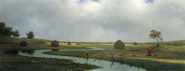
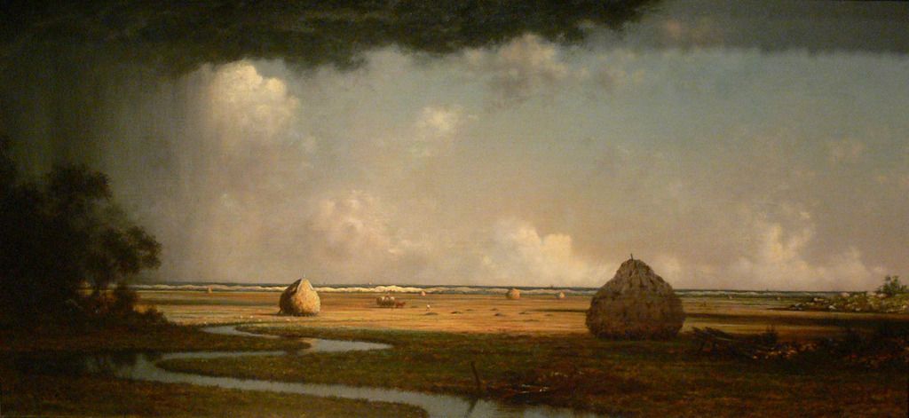
Matin Johnson Heade was a famous painter, and he specialized in Salt Marshes. While he never sketched up Duxbury, he does have one hanging in the Currier Museum of Art in Manchester NH entitled "Marshfield Meadows." Someone who isn't from Duxbury- like Heade- might not recognize that most of that marsh is Duxbury. Heade did paint a few Marshfield shots, so maybe he was more local than I'm giving him credit for.
The one showing a thunderstorm heading for the marsh sure looks a lot like the view from the marsh about where I think the Steve River should be, and that's Duxbury, not Marshfield. Pretty close to exactly, actually.
Either way, our little marshes did make it on to some museum walls, always a good thing.
This comment has been removed by the author.
ReplyDelete