Wednesday, March 16, 2016

Nor'easter Incoming For Sunday/Monday?


Winter wasn't going to let us off the hook without one more backhand slap. Did you really think it would?

We've had a mild winter, a welcome change after all that Siberia stuff we had a year ago. Cape Cod may have gotten a bit more than her average for snowfall, but a winter where Cape Cod outsnows Boston is an anomaly.

We have a shot at some more snow this Monday, as a storm will develop offshore and see how close she can get to New England. She'll arrive during what may be our last blast of cold weather this weekend.

She could very well miss us. We're several days away. It is one of those two-track scenarios where Track #1 means that the storm goes out to sea, and Track #2 means that we get a rain/wind/snow event.

There's a full moon on Wednesday, and that could provide some Aftersurf if the storm throws waves at us from afar (she's expected to hit Canada as a blizzard), especially Tuesday.

We're too far away to say for sure what will happen, and even if we guess, we have no idea of how much snow will fall, where the rain/snow line would set up and a zillion other things.

I saw no snow totals forecast. I did see wind gust charts giving us gale-force winds. The storm would clip Massachusetts, and mainly be a SE Massachusetts event.

If it hits, the weather would go downhill Sunday night. The storm would be offshore on Monday, and be done with us by Monday night.

Again, it may miss us, most likely will... we just want you to keep an eye on the weather for the next few days. We'll keep you updated.


Monday, March 14, 2016

Ocean State Job Lot Opens In Wareham


East Wareham was down, but they were never out. 

Things looked bad for the east side of the 'Ham when Wal-Mart left the Cranberry Plaza. Coming on the heels of Staples hauling up stakes a few years ago, it looked like a deathblow for a whole section of town. Wally was the engine that drove the local economy.

More than one local who I chatted with mentioned how leisurely it was to drive on the Cranberry Highway since Wally moved along. It used to be awful, and you were taking your life in your hands any time you tried to cross it... especially on foot.

It's tough to replace Wally. You don't do it with just one store it seems, as two stores have rushed in to fill the void created by the Drang nach Westen of Walter Mart. Cardi's (of Wareham) is coming soon, and the Ocean State Job Lot just opened.

Coming soon... Cardi's!
So, with Wally just down the road a bit, and two new stores setting up shop in Wally former nest, what's not to like?

I do worry some about the Buzzards Bay version of the Ocean State Job Lot, as I can't imagine that the demand for OSJL's particular inventory can support two stores within a mile or two of each other... but I also do this for a living, so what the Hell do I know?

 Locals recall that Buzzards Bay once had a Burger King, but that it moved down into Wareham. Dunkin' filled the void, and would be the leading candidate to shift into the OSJL's Buzzards Bay location if they decided to just host one store in the area. I can see Dunkin' wanting very badly to be posted up on the Belmont Circle rotary.

But that's putting the cart in front of the horse. For now, we picked up some new jobs, we filled an ugly gap in a crucial local marketplace, and we'll see how things shake out from there.


This sort of kills my plans to write about the abandoned Wal-Mart being used to house and supply UN troops (Chinese and North Korean), who are being based here for when the one-world government comes to confiscate our guns.

I was going to get my friend Tristan to pose outside the abandoned Wal-Mart in a homemade UN jacket as a sneaky-looking North Korean occupier. He's of Japanese descent, but he'd pass in a pinch.

Now, I'll never get on Infowars.com. Maybe I can get a Jew or a Freemason poisoning a well.


I want the ship clock up there for a blank spot on my office wall....

... as well as this thing to pick cookie sheets up with that looks like Cookie Monster somehow got a baby up in Kermit T. Frog.

Sunday, March 13, 2016

The Irish Riviera

Duxbury Beach, courtesy of the Duxbury Beach Residents Association

I grew up on Duxbury Beach, an isolated neighborhood on a peninsula stretching out into Cape Cod Bay.

Duxbury Beach, a cottage neighborhood in the 1970s, was very much unlike Duxbury Proper. As is the case with any isolated kids (during the height of the Baby Boom, my neighborhood had 3 other kids in an area of about a square mile), I was different than the kids in town.

Many people who I went to high school with thought that I was from Marshfield. Others thought that I was "spiritually" from Marshfield, as Vegas villages like Green Harbor and Brant Rock were effectively closer to my home than any Duxbury neighborhood.

People closer to the truth (myself included, for a while) thought instead of a run of "Beach People" stretching from about Quincy to the end of the Cape.

In reality, I was just a citizen of Duxbury's very small chunk of the Irish Riviera.
Hull, courtesy of Nathan McKelvey


We'll be talking Irish Riviera today, to get your mind all proper-like as St. Patrick's Day draws near. We shall explore what a Riviera is, why we have so many Irish, how so many of them ended up on the South Shore and whatever else comes into my head as I bang away at Ol' Momma Keyboard here.

Let's start by discussing what a Riviera is. The famous one is the French Riviera/Cote d'Azur, which is France's coastline on the Mediterranean Sea.

The Cote d'Azur is a resort area. You know how they say that the French all take August off? This is where they go. British, continental and even Russian tourists also started arriving in droves. A 1763 British author wrote of the benefits of oceanfront vacations, and by the end of the 19th century, it was the thing to do.

Originally an aristocracy thing, this newfound (coastal people were generally thought of as a sort of salty hillbilly for much of history) love of seaside resort life soon spread down to the proles.

In the United Kingdom, factories would often close for a week or two in the summer to service and repair the machines. This would loose the workers upon whatever resort areas they could afford to get to. They frequently chose the seaside... maybe get a cottage on the Isle of Wight, if it's not too dear.

This love of seaside resorts definitely bled down to the Irish. Pale and hard-drinking, they were the perfect candidates for the brief two-month-summers of Massachusetts beach life. They just didn't figure it out until they got to America.

Marshfield, thanks to Annaliese Sviokla!
The Irish love America, and the 33 million of them here today equal about 10.5% of the US population. There are more Irish in America than there are Irish in Ireland.

As you probably guessed, most of America's Irish live in California, followed by places like Texas, Florida and Ohio. However, those are just population numbers. When you get to the leaders by % of Population as Irish, your leaders are New York, Pennsylvania and Massachusetts.

Massachusetts takes the title via a robust 21.2% hit of Irish in their population. That's about double the US average. Six of the top ten Irish towns in America are in Massachusetts, and we dominate the top 20, top 30 and top 100 as well.

Milton, MA 38%
Pearl River, NY 38%
Braintree, MA 36%
Collingdale, PA 35%
Marshfield, MA 35%
Scituate, MA 35%
Gloucester City, NJ 34%
Drexel Hill, PA 34%
Pembroke, MA 34%
Weymouth, MA 33%

The numbers are sometimes in dispute, and it depends on who you ask and what your terms are.

47.5 Scituate
46.5 Braintree
45.8 Hull
45.6 Marshfield
44.9 Avon
44.9 Pembroke
44.6 Milton
44.5 Abington
44.3 Whitman
44.2 Hanover
43.4 Weymouth
43.0 Walpole
42.2 Holbrook
41.4 Duxbury
41.2 Norwell
40.8 Hanson
17.4 Boston
23.7 Massachusetts

I'm pretty sure that she's English, but she's posed well
Fieldston (Marshfield) and Squantum (Quincy) sort of trade the title back and forth for Most Irish Neighborhood. Squantum is about 65% Irish, but the difference between Squantum and Fieldston is small enough that the birth of a set of twins or a multiple casualty incident on a road outside of a pub may tip the balance one way or the other.

Most of these Irish started off in Boston. Catholicism was prohibited by the Puritans in Massachusetts, so the Irish were either not coming or pretending to be Scots for a lot of our history.

In the 1820s, various projects like canals, roads and railroads needed cheap labor. Irish immigration skyrocketed. The Great Hunger, where a blight killed off the potatoes which the Irish had come to depend on disproportionately, scattered the Irish like a sort of Mick Pinata.

Two million Irish arrived between 1820 and the US Civil War. They were attracted to cities, where Irish communities were springing up. They were also popular (at least as labor) in any town with a mill. The influx was only slowed by the Great Depression.

More Irish numbers:

Period
Number of immigrants from Ireland

1820-1830 54,338 1911-1920 146,181
1831-1840 207,381 1921-1930 211,234
1841-1850 780,719 1931-1940 10,973
1851-1860 914,119 1941-1950 19,789
1861-1870 435,778 1951-1960 48,362
1871-1880 436,871 1961-1970 32,996
1881-1890 655,482 1971-1980 11,940
1891-1900 388,416 1981-1990 31,969
1901-1910 399,065 1991-2004 62,447

My favorite anti-Irish quote, used completely out of context here... "You will scarcely ever find an Irishman dabbling in counterfeit money, or breaking into houses, or swindling; but if there is any fighting to be done, he is very apt to have a hand in it."

Boston had 35,000 Irish (about 25% of her total population) by 1850. They have banged out 3-7 kids per family ever since. They also got scattered around, as the Irish tend to do.


S'up, girls?
How did the South Shore get so Irish? Were there mills all over Marshfield and Pembroke? When did the Eyes start arriving?

Yes, we did have some mills. There were even fringe industries that attracted Irish, like Irish Mossing in Scituate. Those features brought a lot of Green to SE Massachusetts. You'd also have Irish workers who had earned enough to get out of the city, looking for a more pastoral lifestyle. This was especially true of retiring Boston cops.

After WWII, and with the prosperity following it, many Irish returning from war took the opportunity to head for the sticks. The highway system (especially Route 3, which should probably have an Irish nickname like Mick Street or Paddy Road) provided access to what was already being called the Irish Riviera.

There was yet another Irish Diaspora that grew from the busing era. Any moneyed Mick got the heck out of Dodge when the city started getting ugly. Every town on the South Shore saw their population just about double.

Think I'm lying? Here are the population figures for both 1960 and 1980 for a few South Shore towns, and I could have drawn names from a hat in this region without screwing up my statistical model that much:

Plymouth, 14K to 35K

Duxbury, 4K to 11 K

Marshfield, 6K to 21K

Scituate, 11K to 17K (Scituate reached their Paddy allotment earlier, with the Irish Moss industry)

I'm not saying that the onus of busing involved poor Irish neighborhoods, but you didn't see a lot of people fleeing Wellesley. The South Shore filled with Irish-Am families from Dorchester, South Boston, Charlestown, Hyde Park and so forth. I spent at least one summer as a Dorchester kid living on Duxbury Beach, dating a Boston Latin girl from West Roxbury who summered in Green Harbor. That's straight-up Irish Riviera living, player.

With many South Shore immigrants from Boston, it was just a case where buying and building up a South Shore cottage was cheaper than sending your Irish brood (save the venom, your author is as Irish as a puddle of Guinness vomit outside of Triple O's pub) of 5 kids to private schools from K-12.

Throw in a cycle or two of reproduction, and we are where we stand today.


There is some dispute as to the borders of the Irish Riviera.

New York (Rockaway Beach), Indiana, Michigan and New Jersey all have areas known as the Irish Riviera. However, once you start counting Paddys, Massachusetts can tell all of the other states to start thinking of a new nickname.

The Irish Riviera is generally considered to be the coastal South Shore. Many use a sort of river/tributary system based on Route 3 or especially Route 3A.

Some people include the whole South Shore, as interior towns like Whitman and Pembroke also sport large Mick populations.

Some go the other way, using a Scituate/Marshfield definition. Other people stretch it on to the Cape, to the Kennedy Compound. You still have heavy Irish numbers on Cape Cod, but you should also notice that those % of Irish in a town charts I put up earlier don't have Sandwich, Orleans or Hyannis in them.

I'd personally run the Irish Riviera from Quincy to Sagamore, after which the Cape starts importing tourists and summer people of every stripe to f*ck up the numericals. Bourne is the first town in a long run of coastal Massachusetts towns that doesn't make it onto those % of Irish in population charts, although they are most likely in the 25-35% (Editor's Note: 27%) range.

Besides, the Cape Cod Canal makes for an excellent natural border.


Will the Irish Riviera ever lose her unique, Irish domination of the population base?

There is some gentrification going on. Those cottages that were owned by Irish families for so long get sold now and then. Many of these people are Yuppies, looking to flip a cottage into a coastal McMansion. The Irish make for poor Yuppies.

Many of the Branns and Egans and Carrolls (and even the also-Catholic Italian families like the Leones and Palmieris) from my old neighborhood are still holding out, although the veteran Brann that I spoke to tells me that the neighborhood just ain't the same. The Kerrigans scattered across the world, from Plymouth to Florida to Arizona to San Diego to Australia. Even that Bowden kid is shacked up with a French girl on Cape Cod.

However, it would take some Third World birth rates from other nationalities to knock, say, Scituate down from 35-45% Irish. Since the Catholics frown on birth control, they may even crank out 5 kid families for generations to come. People will still flee Boston. Irish families that grew up summering on the Riviera will move there full-time.

Other Irish families buy up neighboring Riviera houses as the kids marry off, and build little compounds. There is one corner of my old Duxbury Beach neighborhood where you could knock on 3 different doors and still get a Deehan, and tiny Ocean Road North once, in 1999, had 6 houses owned by descendants of the same branch of the Flaherty family.

In the end, we'll end up with a thinned-out-but-still-vital Irish Riviera. You won't beat the Mick out of this area for several generations, if ever.


Thursday, March 10, 2016

Where Exactly Do Our Sharks Hang Out?


The coast of Massachusetts has been home to a burgeoning Great White Shark population for a number of years. If you're just finding this out now, I apologize for being the bearer of bad news.

Anyone who even wades into the ocean should want to know how many finned nightmares are swimming around offshore. People who love sharks or who just have a general interest in how nature moves along may also ponder the question now and then.

Are you alive right now because thousands of sharks off of every beach ignored you? Is seeing a shark akin to winning the Powerball while being struck by lightning as you read the Qur'an? Is the answer in the middle somewhere?

While it's impossible to tell how many sharks we have overall with our present technology, you can use certain tricks to get an idea of at least Relative Activity between beaches.

Dr. Gregory Skomal is in this column as much as I am, but he does very important work. He's that guy who you see on the Discovery channel, jabbing harpoons into sharks. He's not hunting, though, just putting tags on them. He has various sorts of tags for Great White Sharks. Some can be tracked from space as the shark moves around. Others pop off the shark, float to the surface, and are gathered by fishermen/returned to scientists for data collection.

The harder Dr. Skomal works, the larger the data pool gets. The payoff favors the scientists at first, but it soon grows large enough that we regular people can almost score it like baseball standings or the presidential primaries.

I can do it right now. Chatham wins the Outer Cape in a rout. Wellfleet and Truro have a nailbiter going on the Bayside Cape, with the winner being dependent on how you score the game. Plymouth has a slight lead over Duxbury for the South Shore championship, while Martha's Vineyard owns a run from Buzzards Bay through Vineyard Sound.

They have a fun way of scoring these totals. One of those tags they use on sharks can be read by various receivers that are floating around various spots off of the Massachusetts coast. Over time, they can get a good idea of which sharks go where. They don't get all of the sharks, but they do gain valuable insight.

They (and we) use two numbers. One of them = "How many tagged sharks does a particular beach see every year? The other one is "How many total readings of tagged sharks does each beach get?" You end up with "We had X amount of visits by Y amount of sharks."

I'm going to try to make my own graphic for this, as it could be problematic if I steal the one from the Cape Cod Times. However, I can give you the numbers I have right now:

Boston: 22 appearances by 1 Great White Shark

Cape Ann: 26 appearances by 3 sharks

Massachusetts Bay: 7/1

Scituate: 37/3

Duxbury: 74/2

Plymouth: 104/4

Buzzards Bay (body of water): 3/1

Vineyard Sound: 18:2 (You'd think that Amity would own this contest, but No)

Provincetown: 902/8

Truro: 4748/20

Wellfleet: 6564/5

Orleans: 4367/23

Chatham: 14,124/28

Here are the locations of 11 of the 13 buoys, locations based on me rough-guessing by town:


A Few Things To Know (Or To Try To Find Out):

- I do not know if the sharks on the South Shore or in Boston are ones that were tagged off of Cape Cod. I'll try to get Dr. Skomal on the phone before I publish (never overestimate the pull with important people that this column has), but for now I'd say they were all tagged off of Cape Cod. I'm not aware of Dr. Skomal operating on the South Shore.

- I don't know if 2 of the 4 sharks off of Plymouth are 2 of the 2 sharks off of Duxbury. It is fun to ascribe people scenarios to fish, a la "the two sharks who make it up to Duxbury have a second home" or "two of the four Plymouth sharks are Jewish, and, well, Duxbury Beach is sort of like a sandy little country club" and so forth.

- If the Boston/Scituate/Duxbury/Mass Bay sharks are all the same ones, it implies both a low number (one shark is bad news, don't get me wrong, but if only 4 sharks round the tip of Provincetown and  get to the South Shore, I'm fairly safe when compared to 2 dozen or more making 14,000 appearances off of Chatham) and more of a wide range per shark.

- I have rather extensive archives via my time with different publications on Cape Cod, and have no intention of digging up the maps (I already have to make a phone call, c'mon!), but I'm thinking that, once you imagine these 4 sharks working western Cape Cod Bay, it looks a lot like the route taken by the tagged seals who are released off of Scusset Beach now and then.

- Places where I'd like to see Receiver Buoys that don't have them now... Sandwich, Marshfield, Hull, Hyannis, Dennis, Falmouth and Nantucket.

- I don't know how many RBs are in Buzzards Bay, or where in Buzzards Bay they may be. A good spread running from Wareham to New Bedford to Westport would be proper-like. Our last fatal shark attack was off of  Mattapoisett, in the 1930s.

- I don't know how much receiver buoys and transmitter tags cost, but it might behoove towns with large beach-tourist populations to spend the paper, follow Dr. Skomal's lead, hire some fishermen and try to tag any shark that comes across a sort of mid-Cape-Cod-Bay version of the Rubicon.

- If there are people who watch fishermen catch wicked tunas on TV, it's safe to say that I could sell my Taggin' Porkers show. I'd just need a few colorful fishermen (which, at last count, was all of them) and a bit of grease money to get the process moving.

- I'm not sure how long a shark has to hang around a buoy for it to count as an Appearance. Chatham has 14,000 appearances, but maybe half could be the same 3 or 4 sharks hanging around the edge of the range of the same buoy.

- At least one South Shore town should build a 70 story Quint statue right on the water facing the sea, to scare away any sharks who have seen Jaws (Jaws is viewed as a tragedy in both the human and shark worlds). "The Colossus Of Quint." I'd put it right where the trailer park is in Brant Rock.

- It'd be cool if one really bad-ass shark worked the whole coastline, sort of like how boxers or wrestlers used to barnstorm back in the proverbial Day.

- I still think that, once the sharks eat someone, lifeguarding will shift from beach chairs to boats with fish-finders, sirens, and cell phones. I'd also bet on drones getting in the mix somehow. The Hasselhoff/Pam Anderson/Beach Patrol style of lifeguard may be as much of a relic as a redcoat British soldier with a musket.

- Someone should invent a 50 foot, 50 knot-swimmin' killer whale Orca robot and have it patrol the South Shore. While killing sharks is frowned upon and most likely is illegal, if my robot did up one GWS in front of his buddies, they might all go to the Outer Banks or somewhere.

- If Donald Trump were a Duxbury selectman instead of the GOP front-runner, there would be a 5% chance that we'd at least study the possibility of running an underwater wall from the tip of Provincetown to, say, the tip of Hull. I doubt that the Mexicans would pay for it, but the short-fingered vulgarian would think of something.


Saturday, March 5, 2016

Admission Of Fault In Sandwich Beach Erosion Dispute


The good people of Sandwich got some welcome news recently, as a recently released US Army Corps of Engineers report determined that the Corps was at fault in a Sandwich coastal erosion matter.

The issue at hand is beach sand erosion at Town Neck Beach. The cause is said to be the jetty at the east end of the Canal, on Scusset Beach.

Erosion along Cape Cod Bay is generally a give and take thing. Every wave carries off a bit of your beach, but those waves also steal sand from further up the current from you and dump it on your beach. Nobody wins, but nobody loses that badly... well, for the most part, generally.

Responding to one problem (shipwrecks happening as shipping rounded the treacherous waters off of Cape Cod), the Man created another one. The US Army Corps of Engineers now manage the Canal that was cut through Bourne and Sandwich to circumvent that nastier voyage. That management responsibility includes accessories like lighthouses and jetties.

These accessories, like the jetty off of Scusset Beach, have several functions. Some, like slowing down waves before they mess up Canal shipping, were intentional. Others, like the traffic jams on the bridges spanning the Canal, were matters more of the OOOPS! variety.

"OOOPS!" isn't so bad when you stub your toe or pour too much tequila into a drink, but it becomes Very Bad Indeed when it starts washing your yard away.

The jetty off Scusset stops the flow of sand down from the South Shore beaches as Mother Nature intended it. This fills in Scusset Beach with a nice, fresh layer of sand every X amount of years. By doing so, it deprives anything east of the jetty of the sand that they normally would gain via the motion of the ocean.

For 'bout a third of a mile immediately east of the Canal, it's a fair bargain. You lose out on new sand, but you get the protection of a big, federally-funded-and-maintained rockpile against the storm surf. Every beach gets hammered if the wind hits it, but the jetty blocks the worst of the surf from the dreaded north wind that always beats up Sandwich as a storm pulls away.

Storms aside, the real killer is the Western Maine Coastal Current, which flows southeast along the South Shore before hooking east around where the Canal is. The jetty protects that first area against the current, but the beach beyond it has no such protection.

Look at it from a satellite, zoom in close (Go ahead... look), and you'll see right where that protection runs out.


Beaches like Brewster and Dennis also lack the protection of a jetty of that magnitude, but they at least get the sand that is flowing away from Sandwich and Barnstable. Sandwich, and Town Neck Beach in particular, get hit by the current, they hit by the storm waves.... but they miss out on the replenishing beach sand washing down from Scituate and Manomet. It's lose/lose.

Even things that seem logical and symbiotic, like filling in Town Neck Beach with sand dredged out of the Canal, instead become illogical and parasitic when our friend D. Next Storm comes to town and that new sand washes down to Barnstable and Beyond. "Gone, gone, like the snows of yesteryear."

Sandwich has been losing 2.5 feet of beach a year since the flow of sand was cut off, and that jumped up to over 6 feet a year during the recent rash of coastal storms.

Generally, that's between Sandwich and God. God can't be sued. However, if someone plays God with the coastline, you can take your best James Sokolove at them
.
The admission of fault in the USACOE report (an honorable result, as giving the defendant the right of determining fault often ends up like when the wolf, the coyote and the chicken vote on what to have for dinner) opens up some doors as far as How To Fix This Problem goes.

Section 111 of 1968's River And Harbor Act authorizes up to ten million smackeroos in compensation for damage resulting directly from federal navigation projects.

According to the USACOE's own report, they are directly at fault. That saves Sandwich a lot of money, never a bad thing these days.

If the repairs cost less than ten million dollars, they are Uncle Sam's treat. Anything after that, the town and the feds split it 50/50.

That could also cost Sandwich millions, but they get millions in property taxes from houses along a tourist-drawing beach that pays for itself all over the friggin' town. Even if it's a fortune, it's money well-spent.

The decision should perk up ears in any town along the coast that may, say, have a USACOE seawall or something like that. One must be vigilant. Duxbury Beach residents barely dodged a similar bullet on seawall repairs, with the town about to lay all the costs on the residents before the people spoke up.

Sandwich hasn't won the war yet, but they did just take the Dub in a major battle.


Thursday, March 3, 2016

Bourne Bridge Closed

A quick note to let  you know that the Bourne Bridge is closed this morning, after a car crash.

(Update) Off Cape lane is open.

Tuesday, March 1, 2016

Cape Cod Folks: Book Review


One of the odd things bout the Bible is that it pretty much jumps from Jesus as a toddler to Jesus on His world tour. There's no Teen Jesus part, which would have actually been pretty cool to read about. Maybe not that much happened to Teen Jesus, hence the focus on the birth story and the ending.

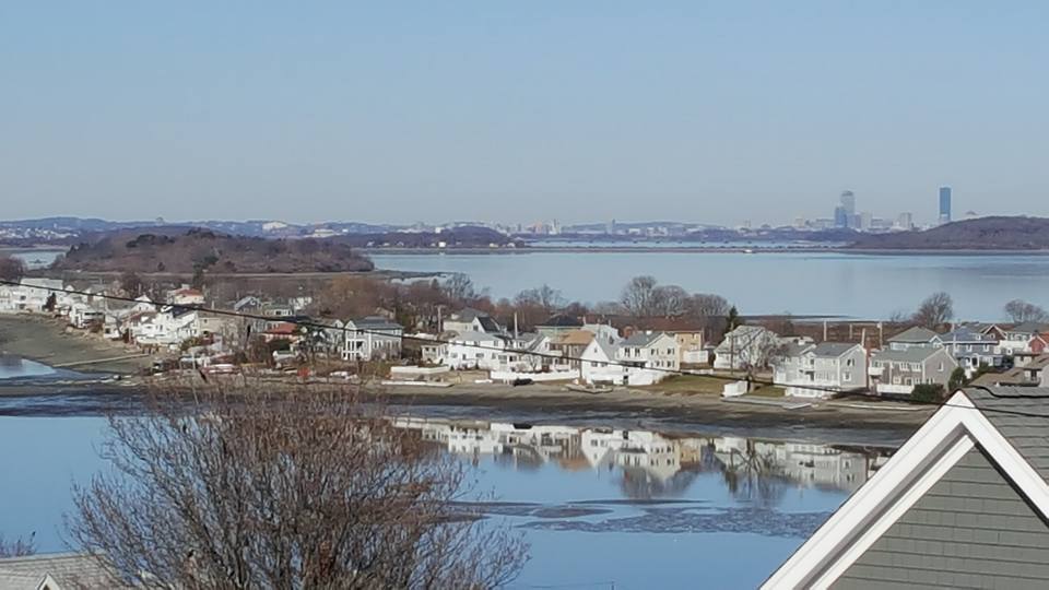
Plymouth is sort of the same way. We all have a basic visual of how 1621 Plimoth looked, and we can drive into Plymouth right damned now if we wanted to know the modern version personally. However, Plimoth was a backwater fairly soon in her history, especially in what is now Southern Plymouth.

Luckily, we have a book set in postbellum Plymouth. Beyond that, you're on your own.

Before we start, a bit of geography.

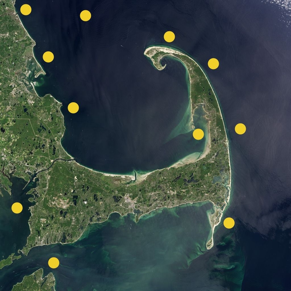
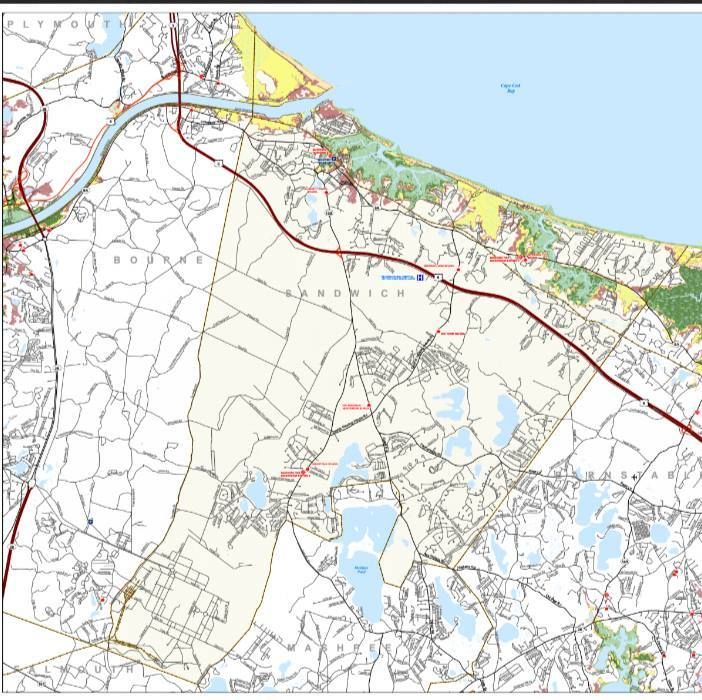
"Cape Cod" today means "all of the land east of the Cape Cod Canal." If you want to get technical, Sandwich and Bourne own a bit of the mainland, with places like Sagamore Beach and Bournedale serving as a buffer zone... sort of like a salty Estonia.

Before they dug the Canal, defining the borders of the Cape was a more dodgy proposition. Your best answer was "east of the Scusset and Manomet Rivers." Some people might point to a line running from the Wareham River to Great Herring Pond in Pymouth. Others would define Cape Cod's border as the Manomet River (bungle "Manomet" as you say it, and you now know why Monument Beach in Bourne is named what it is) as it runs to Great Herring Pond in the Plymouth/Bournedale area, and from Great Herring Pond over coastal streams to just about Ellisville.

These distinctions prove two things. One, "Cape Cod" used to include the southeastern hinterlands of Plymouth. Two, ol' Sarah Pratt McLean Greene wasn't wrong when she wrote "Cape Cod Folks" about Plymouth residents.

I don't read as many books as I used to. The NFL takes up a lot of my time, as does marketing, pornography, reggae, local politics, stuff with the family.... I'm more likely to be up in a website than in a book these days. Some people might look down on that, but hey... I'm reading.

I did feel the need to blast through Cape Cod Folks, as it is set in Cedarville. Our Plymouth road office is in the White Cliffs, in Cedarville. Not much goes on there, and I was curious as to how someone would crank a book out about a post-bellum version of it.


SPOILERS!

The year was 1881, and a woman (Sarah Platt McLean Greene) of both privilege and higher education leaves New York on, as she says, "a mission." I get sort of lost when people speak Olde American, but I think she wanted to minister to some wretches. A classmate of hers was working as a schoolmarm out in the sticks, could no longer keep the job, and offered it to Sarah. It turns out to be an isolated (meaning "the train doesn't go near there") coastal village in Plymouth.

The author uses fake names. She herself is either "Miss Hungerford" or "Teacher." Cedarville is both Kedarville and (colloquially) Wallencamp. Plymouth is Wallen or West Wallen. Falmouth is Farmouth. Sandwich, Bourne, New Bedford, Braintree, Fall River and Taunton all appear as themselves.

The story is a fish out of water tale, sort of an earlier, less funny version of The Egg And I. The author takes a job in a one-room schoolhouse (a building which still stands today, right on the corner of Long Pond Road and Herring Pond Road) for $8 a week, settles into a boarding house and falls in love with the town.

Her ride in a carriage from Plymouth's train depot to Cedarville may be the foundation of the old Cape Cod "sass" story. A socialite took a carriage to Cape Cod. The driver started talking, the socialite shushed him gracelessly, and the rest of the ride went down in silence. When settling the bill, the socialite saw a $1 charge that she couldn't identify, and she asked the driver what it was for. " Sass," said the driver. "I don't take it much, ma'am, and when I do, I charge."

The residents of Cedarville are as hick as it gets. As Dennis Miller once joked, "there were people there who were their own fathers." Most of the people in town have been no further away from Cedarville than Sandwich. The author's first conversation is with a man who explains where her house is by pointing out that "there's miles,and there's Cape Cod  miles, child." It goes downhill from there.

The only visitor comes to cull the town's virgins from the schoolhouse, you don't even get near seeing a black guy, and the Beverly Hillbillies would snicker at the folksy manners of the Cedarville residents. Several of the people mentioned in the story were able to win a Libel suit against the author.

She moves into a boarding house run by a retired sea captain and his wife. There is a son at sea with the scorned-wife name of Philander Keeler. The grandparents can be called nothing but Grandma and Grandpa by anyone who interacts with them, and they live in a one-story house of many rooms known as "The Ark." Most of the business in the comes-to-charm-you village conducts itself through the Ark at some point.

She meets the kids, all of whom- ages 3 through 20- are taught in the same class. If you squint sideways at the class descriptions in To Kill A Mockingbird, you'd have about the right idea of what her lot looks like. There's one kid who goes to class barefoot ("In January. On Cape Cod."), another who has to be dragged in by his father, a third who eventually gets scarlet fever and pretty much dies at her desk, and a rough-but-charming 19 year old named Becky.

Becky gets involved later, although not in a HLA manner. Not that kind of book, player. Becky and the teacher get hung up on the same guy, a lady-killing yacht owner. The author has other shadowy student issues, as she later promises her hand in marriage to a student who is taking to sea.

Cedarville food takes some getting used to. They eat whatever food (beans, pumpkins) is up for harvest for weeks at a time. At one point, every kid in her class raised their hand when asked "Who had split herring for breakfast today?" Popcorn is the big party food, coated with milk and sugar. If you get sick, Grandma boils up some onions and molasses. I don't recall seeing them get any sort of meat other than fish.

It goes without saying that the arrival of the fetching young schoolmarm tunes up every bachelor in town. They visit her constantly, both alone and en masse, hoping to go five-hole on the blue-blood babe. They all want her as a wife, and she eventually narrows it down to the fisherman with money and one of her students. The winner gets killed, of course.

It's a charming little book, and makes a great guide for anyone who wondered how things were around here 135 years ago. Pretty much all of the book is conducted in an isolated area running from about Manomet through Sagamore.

I'll save you some Qs by telling you that there are no car chases, sex scenes, dinosaurs, snipers, rappers-turned-actors, karate fights, CGI, elves, aliens and so forth... so it's already down one star.

I was able to read this book for Nathan, thanks to the good people at Project Gutenberg.


Added Bonus: Quotes!

"The Wallencampers were quick to note the estrangement between us, and affirmed that "Beck was mad, and wouldn't speak to teacher, along o' teacher's goin' with Beck's beau.'"

"Investigating the place where she had been sitting, I found a wild confusion of claws and shells, as carefully denuded of meat as though they had been turned inside out for that purpose.
What was my surprise and mortification to find a like collection at nearly every seat in the school-room, and all the while my flock had seemed unusually silent and attentive; such proficiency had those children acquired in the art of dissecting lobsters.
I saw how many they devoured day by day, and how much water they drank, and I fancied that they themselves grew to partake more and more of the form and character of marine animals. I believed that they could have existed equally well crawling at the bottom of the deep or swimming on its surface."


"And yet, notwithstanding this, they had grown used to a wild ruggedness of nature and condition, a terrible, sublime uncertainty about life and things in general when the wind blew, missing which, in this earthly state, they would have pined most sadly. And I do not believe that they would have exchanged their rugged, storm-swept, wind-beleaguered little section of Cape Cod for a realm in sunny Italy itself; no."


"I knew what it meant—mild winter on the Cape! There's the devil in the old Cape weather, teacher, and he never skipped four seasons yit! If it ain't one time, it must be another. Yis, yis! mild winter on the Cape, and no March to speak on, and a hurricane in summer! "


"A little more than a year after I left Wallencamp, I heard of Grandma and Grandpa Keeler's death. "Very quiet and peaceful," they said concerning Grandma, but I had known what sort of a death-bed hers would be. Scarcely a week after she had passed away, Grandpa Keeler followed her. I had it from good authority that he kept about the house till the last. There was a "rainy spell," and he stood often gazing out of the window "with a lost look on his face," and once he said with a wistful, broken utterance and a pathetic longing in his eyes that did away forever with any opprobrium there might have been in connection with the term, that "it was gittin' to be very lonely about the house without ma pesterin' on him."


"Since then, I have not heard from Wallencamp. It is doubtful whether I ever get another letter from that source. Though singularly gifted in the epistolary art, it is but a dull and faint means of expression to the souls of the Wallencampers—and they will not forget. From the storms that shake their earthly habitations, they pass to their sweet, wild rest beside the sea; and by and by, when I meet them, I shall hear them sing."